Kleberg County Rolled Sketch 10-4
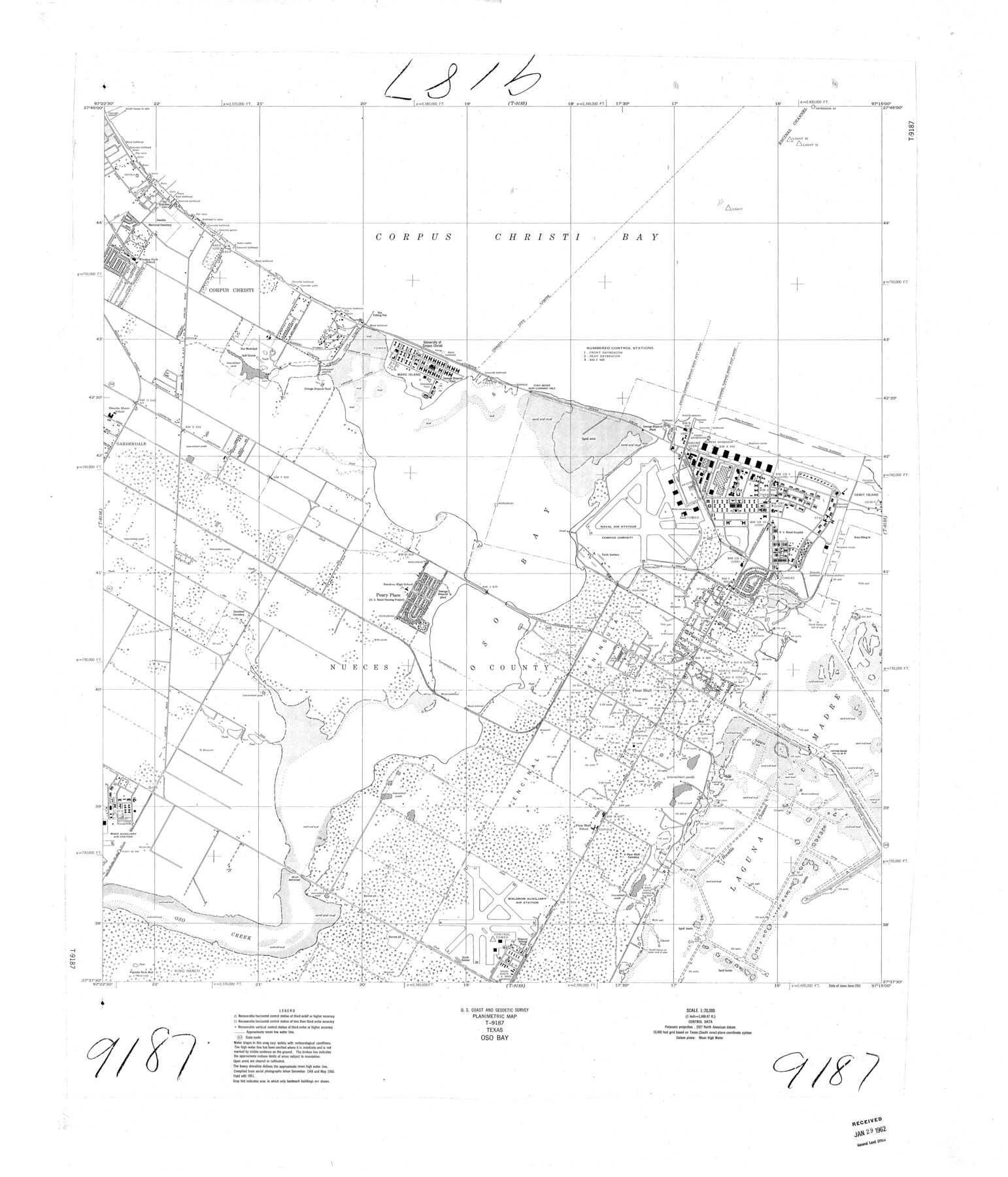
Planimetric Map T-9187, Texas, Oso Bay
-
Map/Doc
9378
-
Collection
General Map Collection
-
Object Dates
1951 (Creation Date)
1962/1/29 (File Date)
-
People and Organizations
U.S. Coast and Geodetic Survey (Publisher)
-
Counties
Nueces
-
Subjects
Surveying Rolled Sketch
-
Height x Width
36.8 x 31.5 inches
93.5 x 80.0 cm
-
Scale
1" = 1666.67 feet
Part of: General Map Collection
Sketch of 103rd Meridian, W. L. Showing Conflict of Capitol Leagues

Print $40.00
- Digital $50.00
Sketch of 103rd Meridian, W. L. Showing Conflict of Capitol Leagues
Size 25.8 x 122.0 inches
Map/Doc 65504
Jefferson County Rolled Sketch 67

Print $20.00
- Digital $50.00
Jefferson County Rolled Sketch 67
2007
Size 21.1 x 23.6 inches
Map/Doc 93426
Map of Colorado County

Print $20.00
- Digital $50.00
Map of Colorado County
1871
Size 18.4 x 19.1 inches
Map/Doc 4594
Flight Mission No. BRE-5P, Frame 190, Nueces County

Print $20.00
- Digital $50.00
Flight Mission No. BRE-5P, Frame 190, Nueces County
1956
Size 18.8 x 22.5 inches
Map/Doc 86836
Index for Texas Railroad ROW & track maps available on microfilm at THD & Archives and Records

Print $2.00
- Digital $50.00
Index for Texas Railroad ROW & track maps available on microfilm at THD & Archives and Records
1977
Size 11.2 x 8.8 inches
Map/Doc 60756
Aransas County NRC Article 33.136 Location Key Sheet

Print $20.00
- Digital $50.00
Aransas County NRC Article 33.136 Location Key Sheet
1979
Size 27.0 x 23.0 inches
Map/Doc 77006
Map of Titus County

Print $20.00
- Digital $50.00
Map of Titus County
1879
Size 23.3 x 14.7 inches
Map/Doc 4082
Flight Mission No. CRC-3R, Frame 96, Chambers County

Print $20.00
- Digital $50.00
Flight Mission No. CRC-3R, Frame 96, Chambers County
1956
Size 18.7 x 22.4 inches
Map/Doc 84834
Haskell County Sketch File 5

Print $4.00
- Digital $50.00
Haskell County Sketch File 5
1856
Size 10.1 x 8.1 inches
Map/Doc 26124
Dallam County Sketch File A

Print $20.00
- Digital $50.00
Dallam County Sketch File A
1903
Size 32.3 x 20.9 inches
Map/Doc 11281
Sulphur River, Harts Bluff Sheet

Print $3.00
- Digital $50.00
Sulphur River, Harts Bluff Sheet
1919
Size 13.1 x 18.0 inches
Map/Doc 78329
Township 15 South Range 15 West and Fractional Township 16 South Range 15 West, South Western District, Louisiana

Print $20.00
- Digital $50.00
Township 15 South Range 15 West and Fractional Township 16 South Range 15 West, South Western District, Louisiana
1875
Size 19.6 x 24.7 inches
Map/Doc 65861
You may also like
United States - Gulf Coast - Padre I. and Laguna Madre Lat. 27° 12' to Lat. 26° 33' Texas

Print $20.00
- Digital $50.00
United States - Gulf Coast - Padre I. and Laguna Madre Lat. 27° 12' to Lat. 26° 33' Texas
1913
Size 26.8 x 18.4 inches
Map/Doc 72817
Wilson County Working Sketch 14

Print $20.00
- Digital $50.00
Wilson County Working Sketch 14
1987
Size 31.9 x 36.2 inches
Map/Doc 72594
Flight Mission No. CLL-1N, Frame 40, Willacy County

Print $20.00
- Digital $50.00
Flight Mission No. CLL-1N, Frame 40, Willacy County
1954
Size 18.5 x 22.2 inches
Map/Doc 87021
Wichita County

Print $20.00
- Digital $50.00
Wichita County
1971
Size 35.8 x 37.7 inches
Map/Doc 77457
Gregg County Working Sketch 9

Print $20.00
- Digital $50.00
Gregg County Working Sketch 9
1939
Size 20.3 x 34.8 inches
Map/Doc 63275
Dawson County Sketch File 21

Print $20.00
- Digital $50.00
Dawson County Sketch File 21
1953
Size 12.2 x 24.5 inches
Map/Doc 11297
[George Tenille Grant, Brazoria County, Texas]
![10751, [George Tenille Grant, Brazoria County, Texas], Maddox Collection](https://historictexasmaps.com/wmedia_w700/maps/10751-1.tif.jpg)
Print $3.00
- Digital $50.00
[George Tenille Grant, Brazoria County, Texas]
Size 11.2 x 9.2 inches
Map/Doc 10751
Flight Mission No. BRA-16M, Frame 118, Jefferson County

Print $20.00
- Digital $50.00
Flight Mission No. BRA-16M, Frame 118, Jefferson County
1953
Size 18.6 x 22.1 inches
Map/Doc 85728
Jefferson County Sketch File 10

Print $32.00
- Digital $50.00
Jefferson County Sketch File 10
Size 8.0 x 6.8 inches
Map/Doc 28125
Flight Mission No. DQN-2K, Frame 75, Calhoun County

Print $20.00
- Digital $50.00
Flight Mission No. DQN-2K, Frame 75, Calhoun County
1953
Size 18.7 x 22.3 inches
Map/Doc 84267
Clay County Working Sketch 14

Print $20.00
- Digital $50.00
Clay County Working Sketch 14
1984
Size 46.9 x 34.5 inches
Map/Doc 68037
Colorado County Working Sketch 1

Print $20.00
- Digital $50.00
Colorado County Working Sketch 1
1897
Size 16.2 x 21.3 inches
Map/Doc 68101