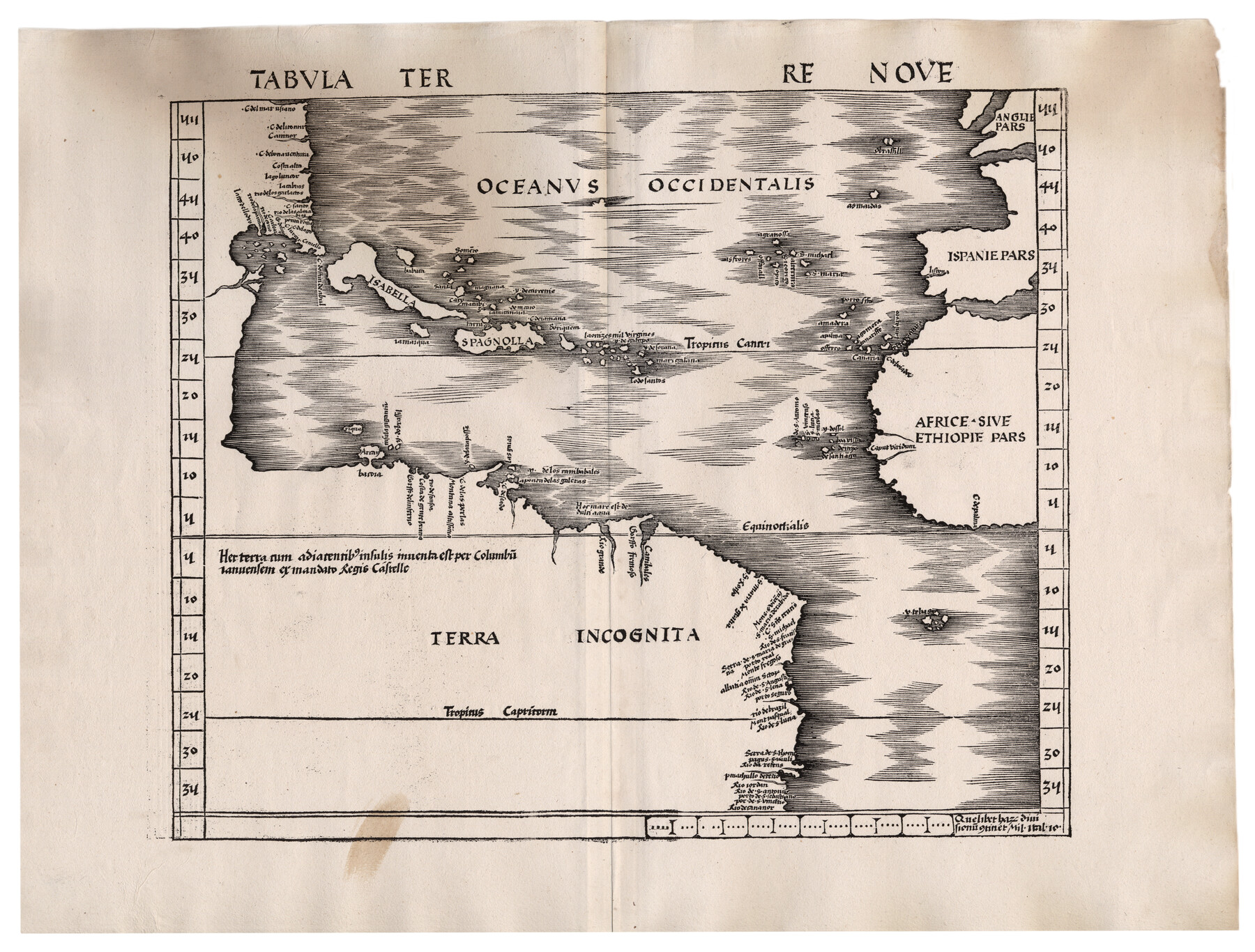
Tabula Terre Nove
[The Admiral's Map]
-
Map/Doc
93800
-
Collection
Holcomb Map Collection
-
Object Dates
1513 (Creation Date)
-
People and Organizations
[Johann Schott] (Printer)
[Martin Waldseemüller] (Author)
-
Subjects
Africa Atlas Europe North America South America
-
Height x Width
18.7 x 24.6 inches
47.5 x 62.5 cm
-
Comments
Courtesy of Frank and Carol Holcomb.
-
URLs
https://medium.com/save-texas-history/mapping-texas-from-frontier-to-the-lone-star-state-3558b0c11e9f#.2f6iz56ps
Part of: Holcomb Map Collection
Map of Texas and the Countries Adjacent compiled in the Bureau of the Corps of Topographical Engineers from the Best Authorities

Print $2.00
- Digital $50.00
Map of Texas and the Countries Adjacent compiled in the Bureau of the Corps of Topographical Engineers from the Best Authorities
1844
Size 8.1 x 5.0 inches
Map/Doc 93868
Map of the United States with the contiguous British & Spanish Possessions compiled from the latest & best authorities

Print $40.00
- Digital $50.00
Map of the United States with the contiguous British & Spanish Possessions compiled from the latest & best authorities
1818
Size 36.9 x 59.5 inches
Map/Doc 93843

La Riviere de Missisipi, et ses environs, dans l'Amerique Septentrionale

Print $20.00
- Digital $50.00
La Riviere de Missisipi, et ses environs, dans l'Amerique Septentrionale
1715
Size 22.0 x 27.8 inches
Map/Doc 96518
Map of Europe designed to accompany Smith's Geography for Schools

Print $20.00
- Digital $50.00
Map of Europe designed to accompany Smith's Geography for Schools
1850
Size 9.8 x 12.1 inches
Map/Doc 93892
A Map of Louisiana and Mexico

Print $20.00
- Digital $50.00
A Map of Louisiana and Mexico
1820
Size 43.8 x 32.9 inches
Map/Doc 94945
A Map of the United States of Mexico as organized and defined by the several Acts of the Congress of that Republic

Print $20.00
- Digital $50.00
A Map of the United States of Mexico as organized and defined by the several Acts of the Congress of that Republic
1847
Size 24.3 x 30.6 inches
Map/Doc 93876
Map of the United States

Print $20.00
- Digital $50.00
Map of the United States
1851
Size 25.1 x 25.3 inches
Map/Doc 93899
Qvarte Partie Dv Monde

Print $20.00
- Digital $50.00
Qvarte Partie Dv Monde
1575
Size 15.3 x 18.9 inches
Map/Doc 93806
Pressler's Map of the State of Texas

Print $40.00
- Digital $50.00
Pressler's Map of the State of Texas
1862
Size 48.0 x 52.7 inches
Map/Doc 95714

America siue India Nova ad magnae Gerardi Mercatoris aui Vniversalis imitationem in compendium redacta

Print $20.00
- Digital $50.00
America siue India Nova ad magnae Gerardi Mercatoris aui Vniversalis imitationem in compendium redacta
1585
Size 16.9 x 20.2 inches
Map/Doc 93808
You may also like
Webb County Rolled Sketch 66

Print $20.00
- Digital $50.00
Webb County Rolled Sketch 66
1957
Size 31.9 x 21.8 inches
Map/Doc 8215
Polk County Sketch File 7

Print $6.00
- Digital $50.00
Polk County Sketch File 7
1860
Size 12.1 x 7.9 inches
Map/Doc 34131
Culberson County Rolled Sketch 27

Print $20.00
- Digital $50.00
Culberson County Rolled Sketch 27
1922
Size 26.8 x 34.9 inches
Map/Doc 5656
Flight Mission No. BQR-9K, Frame 48, Brazoria County

Print $20.00
- Digital $50.00
Flight Mission No. BQR-9K, Frame 48, Brazoria County
1952
Size 18.7 x 22.2 inches
Map/Doc 84052
Harrison County Boundary File 2

Print $40.00
- Digital $50.00
Harrison County Boundary File 2
Size 22.6 x 7.7 inches
Map/Doc 54416
Map No. 1 - Rio Bravo del Norte section of boundary between the United States & Mexico agreed upon by the Joint Commission under the Treaty of Guadalupe Hidalgo

Print $20.00
- Digital $50.00
Map No. 1 - Rio Bravo del Norte section of boundary between the United States & Mexico agreed upon by the Joint Commission under the Treaty of Guadalupe Hidalgo
1852
Size 18.3 x 27.0 inches
Map/Doc 72863
El Paso County Working Sketch 7

Print $20.00
- Digital $50.00
El Paso County Working Sketch 7
1928
Size 25.7 x 16.9 inches
Map/Doc 69029
General Highway Map, Camp County, Morris County, Titus County, Texas

Print $20.00
General Highway Map, Camp County, Morris County, Titus County, Texas
1961
Size 24.7 x 18.1 inches
Map/Doc 79400
Bailey County Sketch File 11

Print $80.00
- Digital $50.00
Bailey County Sketch File 11
Size 21.6 x 20.5 inches
Map/Doc 10886
Webb County Rolled Sketch 28

Print $20.00
- Digital $50.00
Webb County Rolled Sketch 28
1932
Size 27.5 x 20.6 inches
Map/Doc 8186
Archer County Sketch File 13

Print $4.00
- Digital $50.00
Archer County Sketch File 13
Size 11.8 x 8.7 inches
Map/Doc 13648
Colonization and Trade in the New World

Colonization and Trade in the New World
1977
Size 23.1 x 30.3 inches
Map/Doc 96835