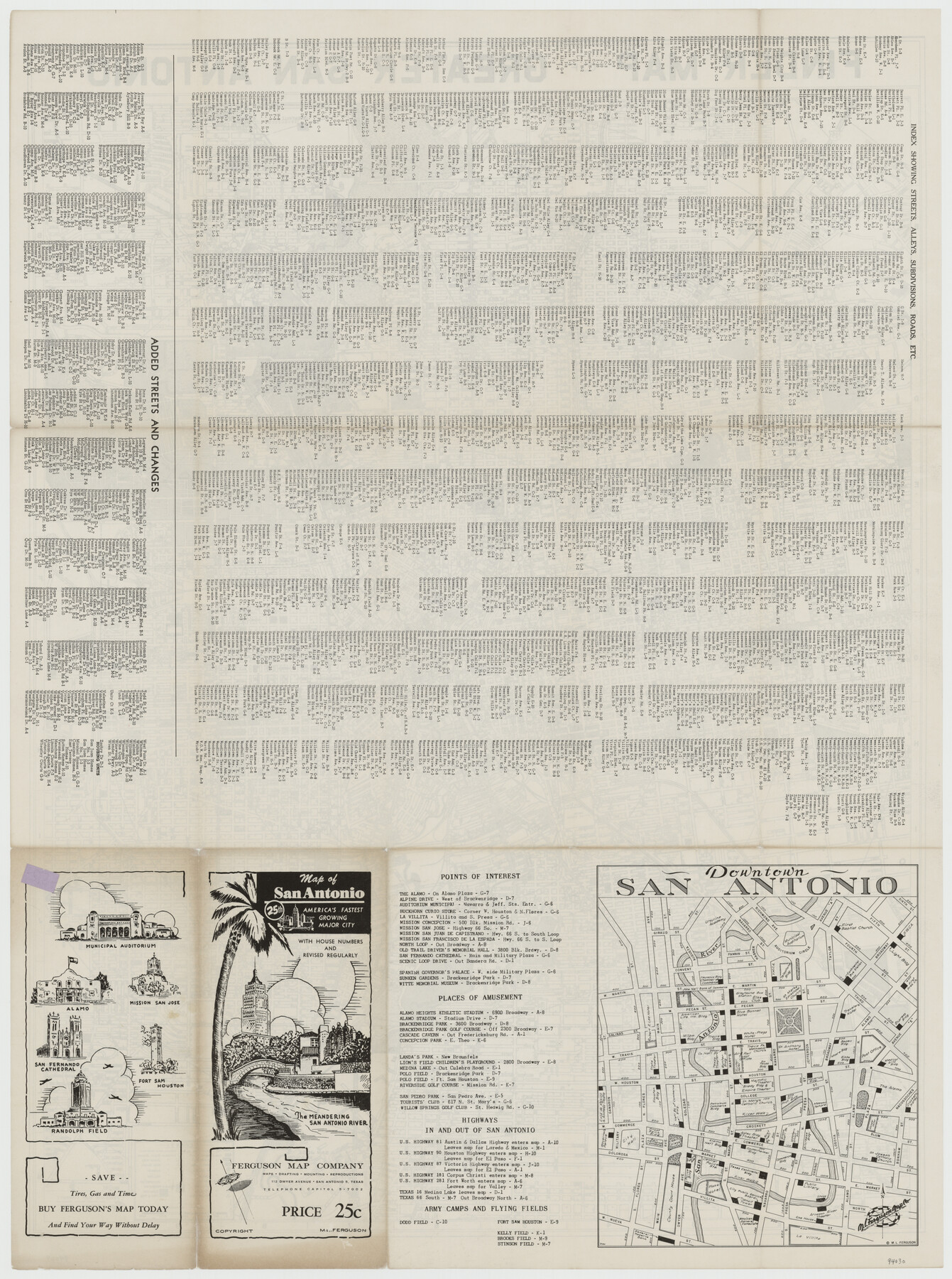
Finder Map of San Antonio
[verso]
-
Map/Doc
94030
-
Collection
General Map Collection
-
Object Dates
1950 (Creation Date)
-
People and Organizations
Ferguson Map Company (Publisher)
M.L. Ferguson (Publisher)
-
Subjects
City
-
Height x Width
28.7 x 21.4 inches
72.9 x 54.4 cm
-
Medium
paper, etching/engraving/lithograph
-
Comments
See reverse (94029) for detailed map of San Antonio.
Related maps
Finder Map of Greater San Antonio

Print $20.00
- Digital $50.00
Finder Map of Greater San Antonio
1950
Size 28.7 x 21.4 inches
Map/Doc 94029
Part of: General Map Collection
Crane County Rolled Sketch 23

Print $20.00
- Digital $50.00
Crane County Rolled Sketch 23
2002
Size 23.9 x 34.3 inches
Map/Doc 76426
[Surveys in Henderson County, Nacogdoches/Houston District]
![69735, [Surveys in Henderson County, Nacogdoches/Houston District], General Map Collection](https://historictexasmaps.com/wmedia_w700/maps/69735.tif.jpg)
Print $2.00
- Digital $50.00
[Surveys in Henderson County, Nacogdoches/Houston District]
Size 11.0 x 7.9 inches
Map/Doc 69735
Winkler County Rolled Sketch 10

Print $40.00
- Digital $50.00
Winkler County Rolled Sketch 10
1958
Size 29.4 x 55.9 inches
Map/Doc 10151
Trinity River, Levee Improvement Districts, Widths of Floodways

Print $20.00
- Digital $50.00
Trinity River, Levee Improvement Districts, Widths of Floodways
1920
Size 31.8 x 23.2 inches
Map/Doc 65254
Jack County Sketch File 26

Print $4.00
- Digital $50.00
Jack County Sketch File 26
1891
Size 8.7 x 9.3 inches
Map/Doc 27563
Young County Rolled Sketch 15

Print $20.00
- Digital $50.00
Young County Rolled Sketch 15
Size 18.0 x 22.7 inches
Map/Doc 8303
Upton County Working Sketch 59

Print $20.00
- Digital $50.00
Upton County Working Sketch 59
Size 21.5 x 34.3 inches
Map/Doc 69556
Duval County Sketch File 46

Print $4.00
- Digital $50.00
Duval County Sketch File 46
Size 8.8 x 9.4 inches
Map/Doc 21400
[Corpus Christi Bay, Padre Island, Mustang Island, Laguna de la Madre, King and Kenedy's Pasture]
![73045, [Corpus Christi Bay, Padre Island, Mustang Island, Laguna de la Madre, King and Kenedy's Pasture], General Map Collection](https://historictexasmaps.com/wmedia_w700/maps/73045.tif.jpg)
Print $20.00
- Digital $50.00
[Corpus Christi Bay, Padre Island, Mustang Island, Laguna de la Madre, King and Kenedy's Pasture]
Size 26.6 x 18.1 inches
Map/Doc 73045
Real County Working Sketch 17

Print $20.00
- Digital $50.00
Real County Working Sketch 17
Size 18.8 x 24.3 inches
Map/Doc 71909
Pecos County Sketch File 101

Print $40.00
- Digital $50.00
Pecos County Sketch File 101
1960
Size 15.6 x 11.7 inches
Map/Doc 34012
Burnet County Sketch File 14a

Print $6.00
- Digital $50.00
Burnet County Sketch File 14a
Size 17.0 x 11.0 inches
Map/Doc 16700
You may also like
Kimble County

Print $40.00
- Digital $50.00
Kimble County
1930
Size 44.8 x 50.3 inches
Map/Doc 95557
Terrell County Working Sketch 22

Print $5.00
- Digital $50.00
Terrell County Working Sketch 22
Size 28.8 x 26.5 inches
Map/Doc 62172
Hemphill County Boundary File 1

Print $18.00
- Digital $50.00
Hemphill County Boundary File 1
Size 9.0 x 3.9 inches
Map/Doc 54612
Denton County Working Sketch 35

Print $20.00
- Digital $50.00
Denton County Working Sketch 35
2008
Size 24.7 x 19.3 inches
Map/Doc 88821
Comanche County Sketch File 18

Print $4.00
- Digital $50.00
Comanche County Sketch File 18
Size 8.4 x 7.8 inches
Map/Doc 19091
Mills County Sketch File 26

Print $4.00
- Digital $50.00
Mills County Sketch File 26
1998
Size 14.3 x 8.8 inches
Map/Doc 31678
Fort Bend County Sketch File 29

Print $20.00
- Digital $50.00
Fort Bend County Sketch File 29
1912
Size 18.3 x 26.1 inches
Map/Doc 11512

Map of The Surveyed Part of Peters Colony Texas

Print $40.00
- Digital $50.00
Map of The Surveyed Part of Peters Colony Texas
1852
Size 53.0 x 28.1 inches
Map/Doc 1964
Kenedy County Rolled Sketch 15

Print $15.00
- Digital $50.00
Kenedy County Rolled Sketch 15
1942
Size 10.2 x 15.2 inches
Map/Doc 46426
Bosque County Working Sketch 29

Print $20.00
- Digital $50.00
Bosque County Working Sketch 29
2009
Size 35.9 x 40.6 inches
Map/Doc 88997
Map of Hidalgo County

Print $20.00
- Digital $50.00
Map of Hidalgo County
1896
Size 44.7 x 26.7 inches
Map/Doc 4978