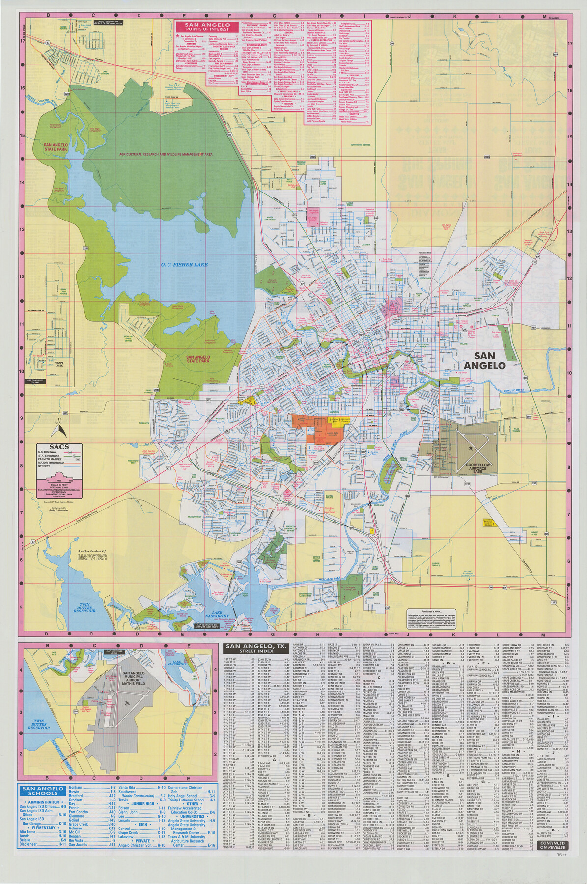
San Angelo/Big Spring, Texas Street Map "A Traveler's Best Friend"
[Recto - San Angelo]
-
Map/Doc
94399
-
Collection
General Map Collection
-
Object Dates
1999 (Copyright Date)
-
People and Organizations
San Antonio Cartographic Services, Inc. (Publisher)
-
Subjects
City
-
Height x Width
37.5 x 24.9 inches
95.3 x 63.3 cm
-
Medium
paper, etching/engraving/lithograph
-
Comments
For map of Big Spring on verso, see 94400. For research only.
Related maps
San Angelo/Big Spring, Texas Street Map "A Traveler's Best Friend"

San Angelo/Big Spring, Texas Street Map "A Traveler's Best Friend"
Size 37.6 x 25.0 inches
Map/Doc 94400
Part of: General Map Collection
Kent County Working Sketch 16

Print $20.00
- Digital $50.00
Kent County Working Sketch 16
1972
Size 32.4 x 31.5 inches
Map/Doc 70023
Harris County Working Sketch 66

Print $40.00
- Digital $50.00
Harris County Working Sketch 66
1955
Size 33.7 x 49.7 inches
Map/Doc 65958
Harris County Working Sketch 63

Print $20.00
- Digital $50.00
Harris County Working Sketch 63
1954
Size 34.0 x 36.8 inches
Map/Doc 65955
Gaines County Rolled Sketch 9

Print $20.00
- Digital $50.00
Gaines County Rolled Sketch 9
Size 20.9 x 29.8 inches
Map/Doc 5929
Floyd County Working Sketch 11

Print $20.00
- Digital $50.00
Floyd County Working Sketch 11
1998
Size 23.0 x 34.1 inches
Map/Doc 69190
A Map of Lewis and Clark's Track, across the Western Portion of North America from the Mississippi to the Pacific Ocean; by order of the Executive of the United States in 1804, 5 & 6

Print $20.00
- Digital $50.00
A Map of Lewis and Clark's Track, across the Western Portion of North America from the Mississippi to the Pacific Ocean; by order of the Executive of the United States in 1804, 5 & 6
1962
Size 11.5 x 25.1 inches
Map/Doc 97174
Brazos River, Clemens State Farm Sheet

Print $20.00
- Digital $50.00
Brazos River, Clemens State Farm Sheet
1915
Size 37.5 x 34.6 inches
Map/Doc 69673
Galveston Bay from a Spanish M. S.

Print $20.00
- Digital $50.00
Galveston Bay from a Spanish M. S.
1846
Size 25.1 x 18.2 inches
Map/Doc 72759
San Jacinto County Rolled Sketch 8

Print $20.00
- Digital $50.00
San Jacinto County Rolled Sketch 8
1940
Size 33.6 x 35.1 inches
Map/Doc 7559
Flight Mission No. BRE-2P, Frame 38, Nueces County

Print $20.00
- Digital $50.00
Flight Mission No. BRE-2P, Frame 38, Nueces County
1956
Size 18.7 x 22.7 inches
Map/Doc 86740
Concho County Working Sketch 19

Print $20.00
- Digital $50.00
Concho County Working Sketch 19
1957
Size 27.3 x 24.9 inches
Map/Doc 68201
Nacogdoches County Working Sketch 3

Print $20.00
- Digital $50.00
Nacogdoches County Working Sketch 3
1935
Size 30.0 x 39.4 inches
Map/Doc 71219
You may also like
Nueces County Rolled Sketch 120

Print $100.00
Nueces County Rolled Sketch 120
1989
Size 11.2 x 10.7 inches
Map/Doc 9636
Guadalupe County Sketch File 25

Print $22.00
- Digital $50.00
Guadalupe County Sketch File 25
Size 12.7 x 15.7 inches
Map/Doc 24717
Ochiltree County Sketch File 1

Print $20.00
- Digital $50.00
Ochiltree County Sketch File 1
1888
Size 30.4 x 26.8 inches
Map/Doc 42201
Bandera County Sketch File 6

Print $4.00
- Digital $50.00
Bandera County Sketch File 6
1877
Size 8.0 x 12.7 inches
Map/Doc 14005
Atascosa County Working Sketch 12

Print $20.00
- Digital $50.00
Atascosa County Working Sketch 12
1926
Size 23.0 x 29.2 inches
Map/Doc 67208
Runnels County Working Sketch 32

Print $20.00
- Digital $50.00
Runnels County Working Sketch 32
1959
Size 27.7 x 24.0 inches
Map/Doc 63630
Dawson County Sketch File 18

Print $10.00
- Digital $50.00
Dawson County Sketch File 18
1940
Size 14.2 x 9.0 inches
Map/Doc 20567
Clay County Boundary File 12

Print $8.00
- Digital $50.00
Clay County Boundary File 12
Size 14.3 x 8.8 inches
Map/Doc 51406
Cochran County Sketch [showing lines run by C. A. Tubbs]
![90443, Cochran County Sketch [showing lines run by C. A. Tubbs], Twichell Survey Records](https://historictexasmaps.com/wmedia_w700/maps/90443-1.tif.jpg)
Print $20.00
- Digital $50.00
Cochran County Sketch [showing lines run by C. A. Tubbs]
Size 9.6 x 23.5 inches
Map/Doc 90443
Topographical Map of the Rio Grande, Sheet No. 1

Print $20.00
- Digital $50.00
Topographical Map of the Rio Grande, Sheet No. 1
1912
Map/Doc 89525
Navigation Maps of Gulf Intracoastal Waterway, Port Arthur to Brownsville, Texas

Print $4.00
- Digital $50.00
Navigation Maps of Gulf Intracoastal Waterway, Port Arthur to Brownsville, Texas
1951
Size 16.6 x 21.5 inches
Map/Doc 65436
Flight Mission No. DQN-3K, Frame 10, Calhoun County

Print $20.00
- Digital $50.00
Flight Mission No. DQN-3K, Frame 10, Calhoun County
1953
Size 18.5 x 22.2 inches
Map/Doc 84342