Refugio County NRC Article 33.136 Sketch 4
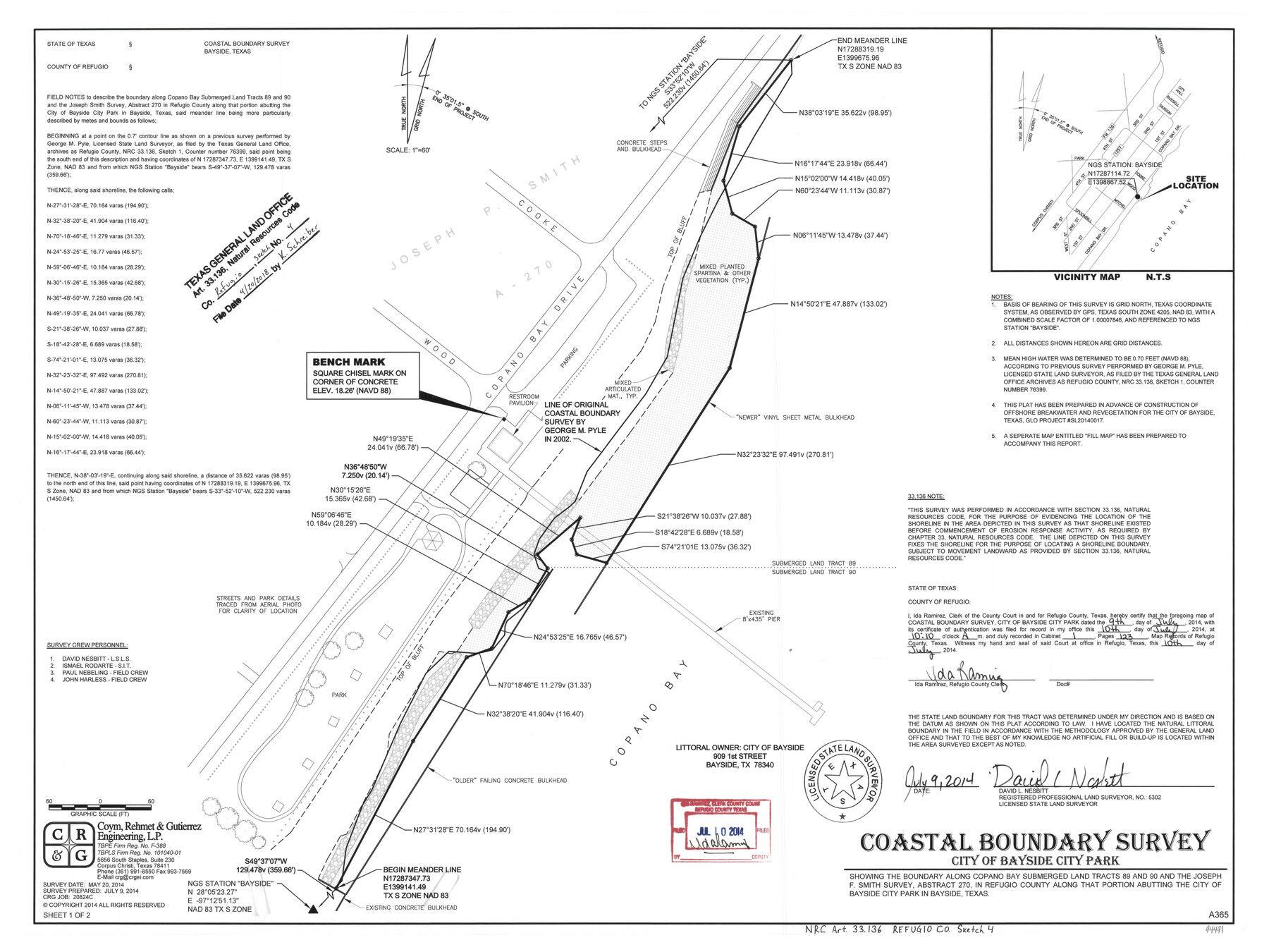
Coastal Boundary Survey, City of Bayside City Park, showing the boundary along Copano Bay submerged land tracts 89 and 90 and the Joseph F. Smith survey, abstract 270, in Refugio County along that portion abutting the city of Bayside City Park
-
Map/Doc
94491
-
Collection
General Map Collection
-
Object Dates
2014/7/9 (Creation Date)
2018/4/20 (File Date)
-
People and Organizations
David L. Nesbitt (Surveyor/Engineer)
-
Counties
Refugio
-
Subjects
Surveying CBS
-
Height x Width
18.0 x 24.0 inches
45.7 x 61.0 cm
-
Medium
multi-page, multi-format
-
Comments
Project: Bayside Shoreline Protection Project No.: SL20140017
Part of: General Map Collection
Rusk County Sketch File 28

Print $24.00
Rusk County Sketch File 28
1937
Size 11.4 x 8.7 inches
Map/Doc 35542
Mustang Island, Nueces County, Texas

Print $20.00
- Digital $50.00
Mustang Island, Nueces County, Texas
1978
Size 40.7 x 36.2 inches
Map/Doc 2500
Liberty County Sketch File 47

Print $4.00
- Digital $50.00
Liberty County Sketch File 47
Size 10.3 x 8.2 inches
Map/Doc 30008
Kleberg County Rolled Sketch 10-26

Print $20.00
- Digital $50.00
Kleberg County Rolled Sketch 10-26
1951
Size 36.6 x 35.5 inches
Map/Doc 9362
Flight Mission No. DIX-3P, Frame 169, Aransas County

Print $20.00
- Digital $50.00
Flight Mission No. DIX-3P, Frame 169, Aransas County
1956
Size 17.8 x 18.3 inches
Map/Doc 83775
Leon County Rolled Sketch 27

Print $40.00
- Digital $50.00
Leon County Rolled Sketch 27
1990
Size 54.3 x 45.0 inches
Map/Doc 9436
[United States]
![97197, [United States], General Map Collection](https://historictexasmaps.com/wmedia_w700/maps/97197.tif.jpg)
Print $20.00
- Digital $50.00
[United States]
1848
Size 17.7 x 37.4 inches
Map/Doc 97197
Andrews County Rolled Sketch 25

Print $20.00
- Digital $50.00
Andrews County Rolled Sketch 25
1947
Size 21.9 x 32.7 inches
Map/Doc 77171
[Surveys in Austin's Colony along the Brazos River]
![164, [Surveys in Austin's Colony along the Brazos River], General Map Collection](https://historictexasmaps.com/wmedia_w700/maps/164.tif.jpg)
Print $20.00
- Digital $50.00
[Surveys in Austin's Colony along the Brazos River]
1833
Size 25.0 x 23.9 inches
Map/Doc 164
Gaines County Sketch File 24

Print $6.00
- Digital $50.00
Gaines County Sketch File 24
1995
Size 8.7 x 3.8 inches
Map/Doc 76362
Caldwell County Working Sketch 12

Print $20.00
- Digital $50.00
Caldwell County Working Sketch 12
1979
Size 47.7 x 44.2 inches
Map/Doc 67842
Coast Chart No. 212 - From Latitude 26° 33' to the Rio Grande Texas

Print $20.00
- Digital $50.00
Coast Chart No. 212 - From Latitude 26° 33' to the Rio Grande Texas
1886
Size 27.7 x 18.3 inches
Map/Doc 72828
You may also like
Hays County Working Sketch 5

Print $20.00
- Digital $50.00
Hays County Working Sketch 5
1929
Size 28.2 x 29.6 inches
Map/Doc 66079
[Surveys along the Trinity River, Bois d'Arc Creek and White Rock Lake]
![256, [Surveys along the Trinity River, Bois d'Arc Creek and White Rock Lake], General Map Collection](https://historictexasmaps.com/wmedia_w700/maps/256.tif.jpg)
Print $2.00
- Digital $50.00
[Surveys along the Trinity River, Bois d'Arc Creek and White Rock Lake]
Size 10.8 x 6.7 inches
Map/Doc 256
Dallas County Boundary File 4

Print $38.00
- Digital $50.00
Dallas County Boundary File 4
Size 8.9 x 3.9 inches
Map/Doc 52123
Fannin County Sketch File 24

Print $4.00
- Digital $50.00
Fannin County Sketch File 24
Size 13.2 x 8.6 inches
Map/Doc 22491
Madison County Working Sketch 4

Print $20.00
- Digital $50.00
Madison County Working Sketch 4
1973
Size 12.7 x 12.9 inches
Map/Doc 70766
Kent County Sketch File A

Print $4.00
- Digital $50.00
Kent County Sketch File A
Size 8.2 x 9.0 inches
Map/Doc 28821
Brewster County Working Sketch Graphic Index, East Part, Sheet 1 (Sketches 1 to 111)

Print $20.00
- Digital $50.00
Brewster County Working Sketch Graphic Index, East Part, Sheet 1 (Sketches 1 to 111)
1952
Size 47.4 x 29.6 inches
Map/Doc 76476
Jefferson Co.

Print $20.00
- Digital $50.00
Jefferson Co.
1918
Size 47.1 x 41.0 inches
Map/Doc 66884
Orange County Sketch File 11a

Print $4.00
- Digital $50.00
Orange County Sketch File 11a
1884
Size 6.1 x 6.1 inches
Map/Doc 33322
Flight Mission No. CRC-1R, Frame 35, Chambers County

Print $20.00
- Digital $50.00
Flight Mission No. CRC-1R, Frame 35, Chambers County
1956
Size 18.9 x 22.5 inches
Map/Doc 84703
[Central Portion of McMullen County]
![91301, [Central Portion of McMullen County], Twichell Survey Records](https://historictexasmaps.com/wmedia_w700/maps/91301-1.tif.jpg)
Print $20.00
- Digital $50.00
[Central Portion of McMullen County]
1884
Size 28.8 x 25.7 inches
Map/Doc 91301
Nacogdoches County Working Sketch 8

Print $20.00
- Digital $50.00
Nacogdoches County Working Sketch 8
1964
Size 28.0 x 22.7 inches
Map/Doc 71224