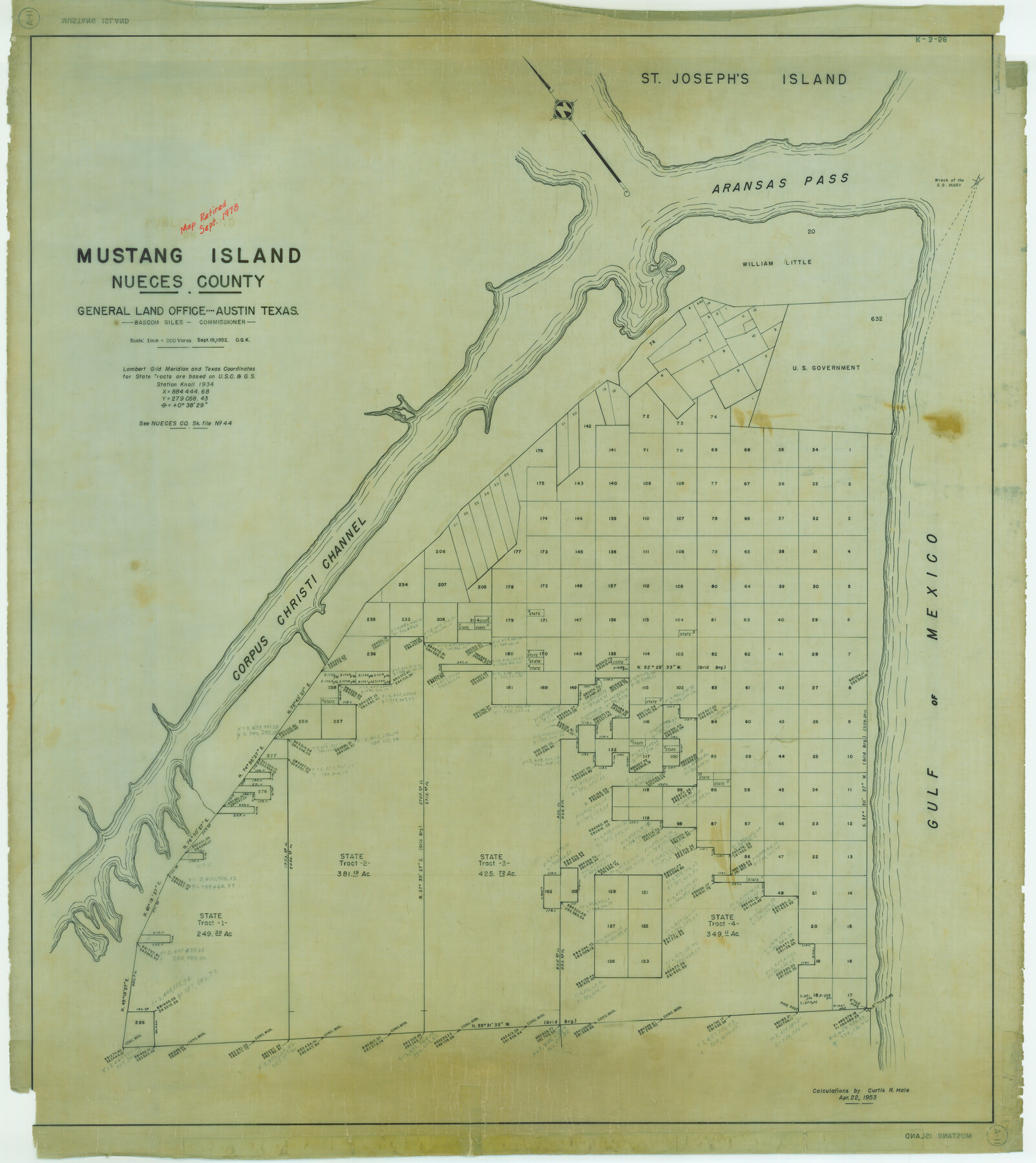
Mustang Island, Nueces County, Texas
K-3-58
-
Map/Doc
2500
-
Collection
General Map Collection
-
Object Dates
1978 (Creation Date)
-
People and Organizations
General Land Office (Publisher)
General Land Office (Author)
-
Counties
Nueces
-
Subjects
Energy Offshore Submerged Area
-
Height x Width
40.7 x 36.2 inches
103.4 x 91.9 cm
-
Comments
Map retired in Sept. 1978.
Part of: General Map Collection
Erath County Sketch File 8

Print $4.00
- Digital $50.00
Erath County Sketch File 8
Size 8.6 x 13.0 inches
Map/Doc 22269
Copy of Surveyor's Field Book, Morris Browning - In Blocks 7, 5 & 4, I&GNRRCo., Hutchinson and Carson Counties, Texas

Print $2.00
- Digital $50.00
Copy of Surveyor's Field Book, Morris Browning - In Blocks 7, 5 & 4, I&GNRRCo., Hutchinson and Carson Counties, Texas
1888
Size 6.9 x 8.8 inches
Map/Doc 62280
Bell County Working Sketch 11

Print $20.00
- Digital $50.00
Bell County Working Sketch 11
1956
Size 31.8 x 24.4 inches
Map/Doc 67351
Pecos County Sketch File 52

Print $10.00
- Digital $50.00
Pecos County Sketch File 52
Size 8.6 x 3.8 inches
Map/Doc 33781
Comanche County

Print $20.00
- Digital $50.00
Comanche County
1944
Size 42.2 x 46.9 inches
Map/Doc 1807
Runnels County Rolled Sketch 18

Print $20.00
- Digital $50.00
Runnels County Rolled Sketch 18
Size 23.1 x 25.3 inches
Map/Doc 7513
Stonewall County

Print $20.00
- Digital $50.00
Stonewall County
1933
Size 40.3 x 34.5 inches
Map/Doc 77428
McLennan County Sketch File 41

Print $44.00
- Digital $50.00
McLennan County Sketch File 41
1963
Size 11.1 x 8.6 inches
Map/Doc 31319
Flight Mission No. CRK-7P, Frame 27, Refugio County

Print $20.00
- Digital $50.00
Flight Mission No. CRK-7P, Frame 27, Refugio County
1956
Size 18.3 x 22.1 inches
Map/Doc 86947
Field Notes of surveys in Hutchinson and Wheeler Counties

Field Notes of surveys in Hutchinson and Wheeler Counties
Map/Doc 81670
Flight Mission No. CRK-3P, Frame 69, Refugio County

Print $20.00
- Digital $50.00
Flight Mission No. CRK-3P, Frame 69, Refugio County
1956
Size 18.5 x 22.2 inches
Map/Doc 86911
Brewster County Rolled Sketch 59D

Print $20.00
- Digital $50.00
Brewster County Rolled Sketch 59D
Size 33.3 x 47.3 inches
Map/Doc 5231
You may also like

Coast Chart No. 211 - Padre I. and Laguna Madre, Lat. 27° 12' to Lat. 26° 33', Texas

Print $20.00
- Digital $50.00
Coast Chart No. 211 - Padre I. and Laguna Madre, Lat. 27° 12' to Lat. 26° 33', Texas
1890
Size 40.1 x 33.7 inches
Map/Doc 73500
Chambers County Sketch File 8

Print $4.00
- Digital $50.00
Chambers County Sketch File 8
Size 8.0 x 10.7 inches
Map/Doc 17544
Subdivision of the East Half of Lot No. 1 in Division "Z" of the Out-Lots adjoining the City of Austin

Print $20.00
- Digital $50.00
Subdivision of the East Half of Lot No. 1 in Division "Z" of the Out-Lots adjoining the City of Austin
Size 32.1 x 42.6 inches
Map/Doc 648
Flight Mission No. DQO-8K, Frame 73, Galveston County

Print $20.00
- Digital $50.00
Flight Mission No. DQO-8K, Frame 73, Galveston County
1952
Size 18.6 x 22.4 inches
Map/Doc 85177
The Republic County of Gonzales. December 29, 1845

Print $20.00
The Republic County of Gonzales. December 29, 1845
2020
Size 14.7 x 21.7 inches
Map/Doc 96160
A Map of Harrison County

Print $20.00
- Digital $50.00
A Map of Harrison County
1846
Size 40.5 x 30.7 inches
Map/Doc 1460
Flight Mission No. CRE-1R, Frame 65, Jackson County

Print $20.00
- Digital $50.00
Flight Mission No. CRE-1R, Frame 65, Jackson County
1956
Size 18.6 x 22.3 inches
Map/Doc 85328
Fannin County Sketch File 7

Print $40.00
- Digital $50.00
Fannin County Sketch File 7
1857
Size 16.8 x 13.5 inches
Map/Doc 22451
Atascosa County Sketch File 8

Print $6.00
- Digital $50.00
Atascosa County Sketch File 8
1857
Size 8.7 x 7.7 inches
Map/Doc 13758
Webb County Working Sketch 64

Print $20.00
- Digital $50.00
Webb County Working Sketch 64
1962
Size 12.8 x 26.1 inches
Map/Doc 72430
Texas Coast Country along the line of the Sunset Route

Texas Coast Country along the line of the Sunset Route
1907
Map/Doc 96713