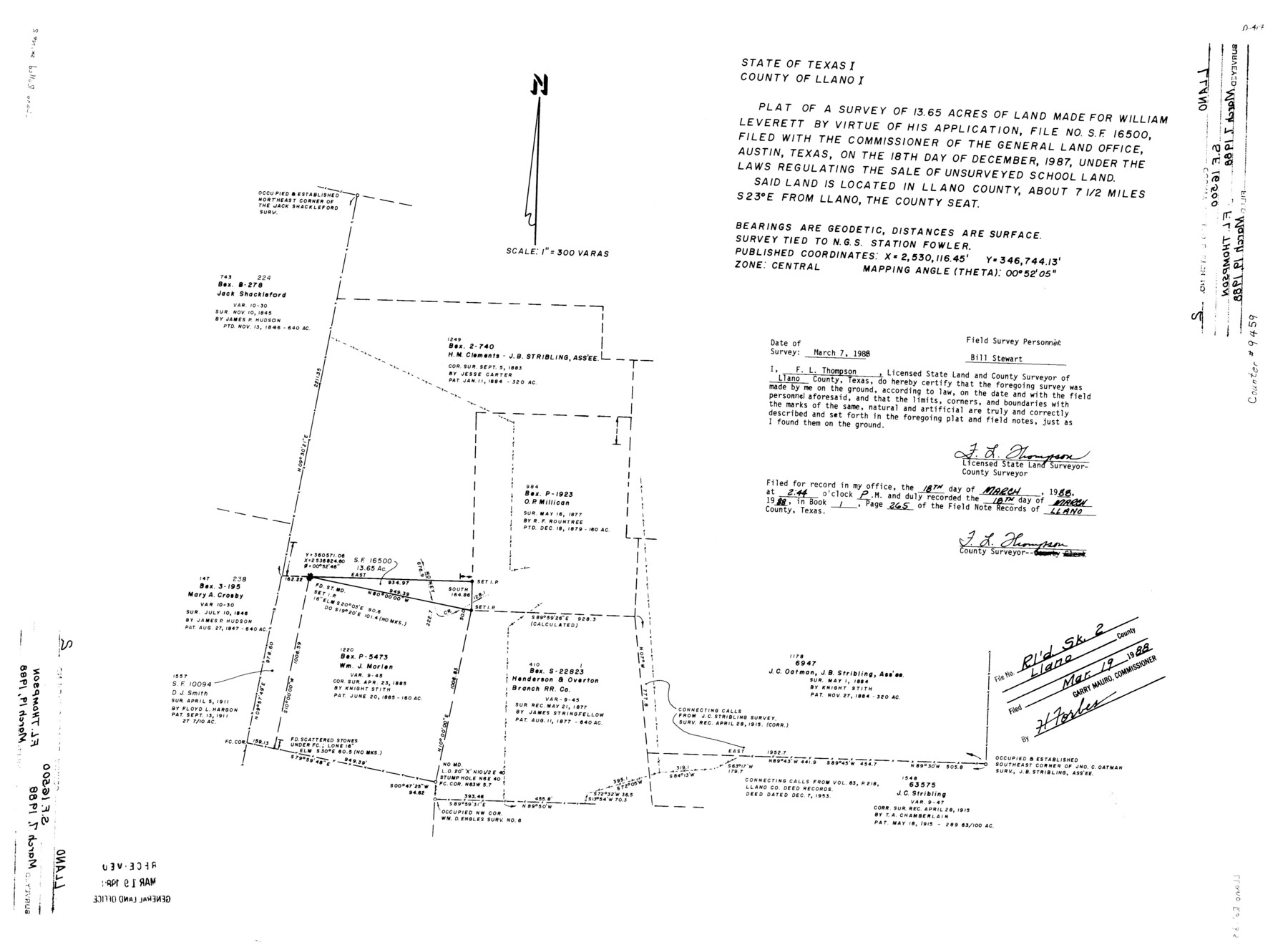
Llano County Rolled Sketch 2
Plat of a survey of 13.65 acres of land made for William Leverett by virtue of his application, file no. SF-16500
-
Map/Doc
9459
-
Collection
General Map Collection
-
Object Dates
3/7/1988 (Survey Date)
3/19/1988 (File Date)
-
People and Organizations
F.L. Thompson (Surveyor/Engineer)
-
Counties
Llano
-
Subjects
Surveying Rolled Sketch
-
Height x Width
18.2 x 27.3 inches
46.2 x 69.3 cm
-
Medium
mylar, print
-
Scale
1" = 300 varas
Part of: General Map Collection
Flight Mission No. DIX-10P, Frame 143, Aransas County

Print $20.00
- Digital $50.00
Flight Mission No. DIX-10P, Frame 143, Aransas County
1956
Size 18.8 x 22.5 inches
Map/Doc 83945
Reeves County Rolled Sketch 15

Print $20.00
- Digital $50.00
Reeves County Rolled Sketch 15
1960
Size 21.6 x 25.2 inches
Map/Doc 7484
Anderson County Working Sketch Graphic Index

Print $40.00
- Digital $50.00
Anderson County Working Sketch Graphic Index
1942
Size 52.0 x 48.3 inches
Map/Doc 76452
Gulf Oil Corp. Fishgide - Port Isabel

Gulf Oil Corp. Fishgide - Port Isabel
1960
Size 12.1 x 22.4 inches
Map/Doc 75981
Flight Mission No. DIX-10P, Frame 76, Aransas County

Print $20.00
- Digital $50.00
Flight Mission No. DIX-10P, Frame 76, Aransas County
1956
Size 18.8 x 22.4 inches
Map/Doc 83937
Motley County Sketch File 5 (N)

Print $8.00
- Digital $50.00
Motley County Sketch File 5 (N)
Size 12.6 x 8.3 inches
Map/Doc 32000
Flight Mission No. CZW-1R, Frame 165, Hardeman County

Print $20.00
- Digital $50.00
Flight Mission No. CZW-1R, Frame 165, Hardeman County
1956
Size 18.7 x 22.4 inches
Map/Doc 85236
Johnson County

Print $20.00
- Digital $50.00
Johnson County
1874
Size 19.9 x 18.0 inches
Map/Doc 3736
Flight Mission No. DQN-2K, Frame 39, Calhoun County

Print $20.00
- Digital $50.00
Flight Mission No. DQN-2K, Frame 39, Calhoun County
1953
Size 18.2 x 22.2 inches
Map/Doc 84244
Zapata County Rolled Sketch 26

Print $20.00
- Digital $50.00
Zapata County Rolled Sketch 26
1982
Size 43.0 x 30.7 inches
Map/Doc 8319
Bexar County Sketch File 45

Print $40.00
- Digital $50.00
Bexar County Sketch File 45
1886
Size 17.2 x 14.2 inches
Map/Doc 14526
Refugio County Sketch File 8a

Print $2.00
- Digital $50.00
Refugio County Sketch File 8a
Size 8.1 x 10.2 inches
Map/Doc 35253
You may also like
Ward County Rolled Sketch 24F

Print $40.00
- Digital $50.00
Ward County Rolled Sketch 24F
Size 30.5 x 65.2 inches
Map/Doc 78232
Smith County Rolled Sketch 6A2

Print $40.00
- Digital $50.00
Smith County Rolled Sketch 6A2
1934
Size 48.7 x 36.7 inches
Map/Doc 10702
Van Zandt County Rolled Sketch 5

Print $20.00
- Digital $50.00
Van Zandt County Rolled Sketch 5
1946
Size 27.1 x 28.1 inches
Map/Doc 8146
Montague County Working Sketch 29

Print $20.00
- Digital $50.00
Montague County Working Sketch 29
1972
Size 27.8 x 22.1 inches
Map/Doc 71095
[Surveys near Calaveras Creek]
![364, [Surveys near Calaveras Creek], General Map Collection](https://historictexasmaps.com/wmedia_w700/maps/364.tif.jpg)
Print $2.00
- Digital $50.00
[Surveys near Calaveras Creek]
1846
Size 10.9 x 8.0 inches
Map/Doc 364
Northern Part of Laguna Madre

Print $20.00
- Digital $50.00
Northern Part of Laguna Madre
1946
Size 43.8 x 34.5 inches
Map/Doc 73523
Map of Val Verde County

Print $40.00
- Digital $50.00
Map of Val Verde County
1898
Size 81.6 x 30.7 inches
Map/Doc 82013
Working Sketch in Dallam County [shows H. & T. C. Ry. Co. Block 47 1/2]
![90649, Working Sketch in Dallam County [shows H. & T. C. Ry. Co. Block 47 1/2], Twichell Survey Records](https://historictexasmaps.com/wmedia_w700/maps/90649-1.tif.jpg)
Print $20.00
- Digital $50.00
Working Sketch in Dallam County [shows H. & T. C. Ry. Co. Block 47 1/2]
1906
Size 18.5 x 18.2 inches
Map/Doc 90649
Comanche County Boundary File 1

Print $20.00
- Digital $50.00
Comanche County Boundary File 1
Size 14.4 x 8.8 inches
Map/Doc 51778
Callahan County, Texas

Print $20.00
- Digital $50.00
Callahan County, Texas
1880
Size 24.1 x 18.5 inches
Map/Doc 89276
Yoakum County

Print $20.00
- Digital $50.00
Yoakum County
1938
Size 24.9 x 24.6 inches
Map/Doc 92446
Flight Mission No. CLL-1N, Frame 39, Willacy County

Print $20.00
- Digital $50.00
Flight Mission No. CLL-1N, Frame 39, Willacy County
1954
Size 18.4 x 22.0 inches
Map/Doc 87020