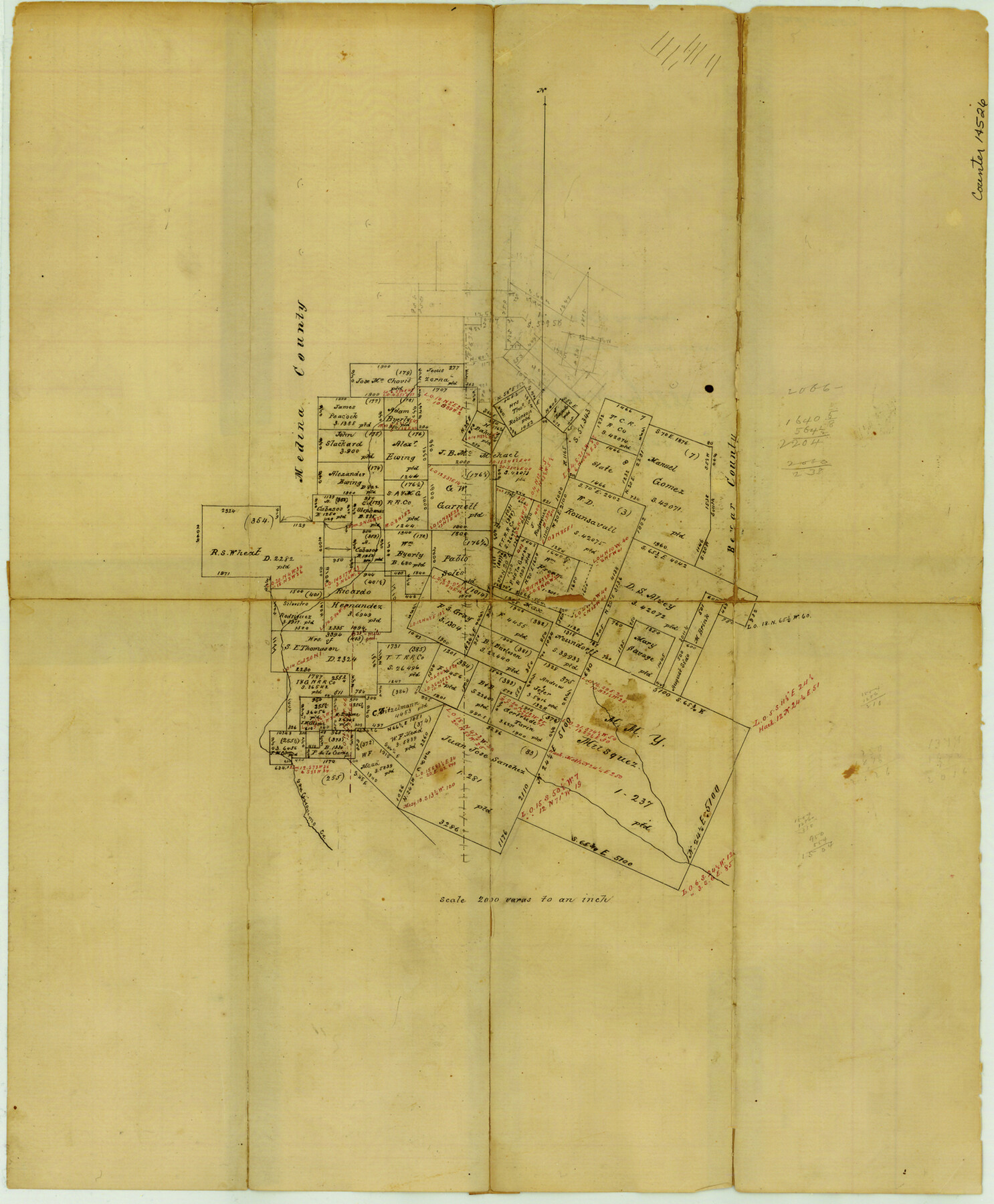
Bexar County Sketch File 45
[Office sketch of large area of surveys near San Geronimo and Culebra Creeks]
-
Map/Doc
14526
-
Collection
General Map Collection
-
Object Dates
1886 (Creation Date)
-
Counties
Bexar
-
Subjects
Surveying Sketch File
-
Height x Width
17.2 x 14.2 inches
43.7 x 36.1 cm
-
Medium
paper, manuscript
-
Scale
1" = 2000 varas
-
Features
San Geronimo Creek
[Culebra Creek]
Part of: General Map Collection
Wichita County Working Sketch 7

Print $20.00
- Digital $50.00
Wichita County Working Sketch 7
1919
Size 20.8 x 13.6 inches
Map/Doc 72516
Zavala County Working Sketch Graphic Index

Print $20.00
- Digital $50.00
Zavala County Working Sketch Graphic Index
1977
Size 42.2 x 48.2 inches
Map/Doc 76751
Flight Mission No. BRE-1P, Frame 7, Nueces County

Print $20.00
- Digital $50.00
Flight Mission No. BRE-1P, Frame 7, Nueces County
1956
Size 18.3 x 22.1 inches
Map/Doc 86615
Pecos County Rolled Sketch 128

Print $40.00
- Digital $50.00
Pecos County Rolled Sketch 128
1949
Size 43.6 x 54.0 inches
Map/Doc 9725
Kerr County Working Sketch 15

Print $20.00
- Digital $50.00
Kerr County Working Sketch 15
1953
Size 36.2 x 38.6 inches
Map/Doc 70046
Williamson County Boundary File 4

Print $40.00
- Digital $50.00
Williamson County Boundary File 4
Size 8.3 x 13.3 inches
Map/Doc 60013
Current Miscellaneous File 61

Print $4.00
- Digital $50.00
Current Miscellaneous File 61
1956
Size 9.3 x 13.6 inches
Map/Doc 74066
Current Miscellaneous File 54

Print $24.00
- Digital $50.00
Current Miscellaneous File 54
1955
Size 11.2 x 8.7 inches
Map/Doc 74042
Kimble County Rolled Sketch 31

Print $20.00
- Digital $50.00
Kimble County Rolled Sketch 31
Size 21.1 x 27.4 inches
Map/Doc 6521
Coleman County Sketch File 37

Print $4.00
- Digital $50.00
Coleman County Sketch File 37
1891
Size 11.1 x 8.4 inches
Map/Doc 18742
Zavala County

Print $20.00
- Digital $50.00
Zavala County
1977
Size 36.6 x 41.6 inches
Map/Doc 77468
Lavaca County Working Sketch 10

Print $20.00
- Digital $50.00
Lavaca County Working Sketch 10
1952
Size 19.1 x 23.8 inches
Map/Doc 70363
You may also like
Bailey County Sketch File 2

Print $40.00
- Digital $50.00
Bailey County Sketch File 2
1892
Size 28.0 x 23.6 inches
Map/Doc 10881
Galveston County Sketch File 40

Print $18.00
- Digital $50.00
Galveston County Sketch File 40
1937
Size 14.3 x 8.8 inches
Map/Doc 23442
Clay County Boundary File 7

Print $14.00
- Digital $50.00
Clay County Boundary File 7
Size 14.3 x 8.8 inches
Map/Doc 51377
Kaufman County

Print $20.00
- Digital $50.00
Kaufman County
1896
Size 44.0 x 28.0 inches
Map/Doc 3751
Flight Mission No. DCL-4C, Frame 145, Kenedy County

Print $20.00
- Digital $50.00
Flight Mission No. DCL-4C, Frame 145, Kenedy County
1943
Size 18.6 x 22.4 inches
Map/Doc 85823
Map of the Southern part of Texas

Print $20.00
- Digital $50.00
Map of the Southern part of Texas
1831
Size 17.5 x 21.3 inches
Map/Doc 94442
Marion County Working Sketch 13

Print $20.00
- Digital $50.00
Marion County Working Sketch 13
1953
Size 33.2 x 36.3 inches
Map/Doc 70789
Sunny San Antonio - The Winter Playground of America

Sunny San Antonio - The Winter Playground of America
1920
Size 9.4 x 7.9 inches
Map/Doc 97040
Galveston Bay from a Spanish M. S.

Print $20.00
- Digital $50.00
Galveston Bay from a Spanish M. S.
1846
Size 25.1 x 18.2 inches
Map/Doc 72759
General Highway Map, Coryell County, Texas

Print $20.00
General Highway Map, Coryell County, Texas
1940
Size 18.4 x 25.4 inches
Map/Doc 79059
Colorado County Working Sketch 17

Print $20.00
- Digital $50.00
Colorado County Working Sketch 17
1952
Size 36.4 x 30.2 inches
Map/Doc 68117
Ward County Sketch File 8

Print $20.00
- Digital $50.00
Ward County Sketch File 8
Size 13.3 x 22.8 inches
Map/Doc 12599