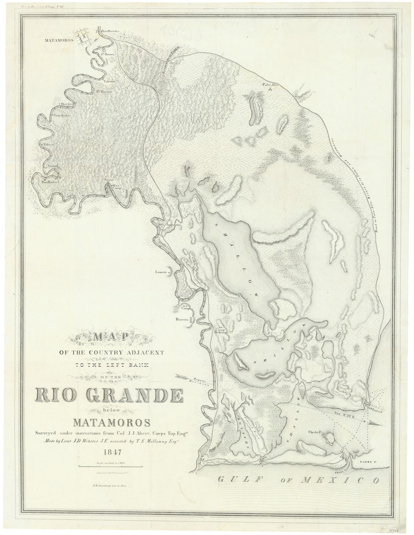
Map of the country adjacent to the left bank of the Rio Grande below Matamoros surveyed under instructions of Col. J.J. Abert, Corps. Top. Engrs.
-
Map/Doc
95177
-
Collection
General Map Collection
-
Object Dates
1847 (Publication Date)
-
People and Organizations
J.J. Abert (Surveyor/Engineer)
J.D. Webster (Surveyor/Engineer)
T.E. Mullowny (Surveyor/Engineer)
Ackerman Lith. (Printer)
-
Subjects
Military
-
Height x Width
27.0 x 20.9 inches
68.6 x 53.1 cm
-
Medium
paper, etching/engraving/lithograph
-
Scale
1 inch to 1 mile
-
Features
Saino
Palo Alto
Road to Palo Alto, Resaca de la Palma and Matamoros
Point Isabel
Clarks I[slan]d
Padre I[slan]d
Brazo Santiago
Boca Chica
Camp Belknap
Burrita
Lomito
San Augustin
Matamoros
San Rafael
Arenal
Falsete
Tres Quilas
S[an]ta Rosalia
Falcone
Resaca de la Palma
Fort Brown
Fort Paredes
Burgos
Part of: General Map Collection
Sketch exhibiting inland channel from Saluria to Corpus Christi traced from a copy of a map belonging to U. S. Engr. Dept.

Print $20.00
- Digital $50.00
Sketch exhibiting inland channel from Saluria to Corpus Christi traced from a copy of a map belonging to U. S. Engr. Dept.
1853
Size 18.3 x 28.3 inches
Map/Doc 73007
Coast Chart No. 210 - Aransas Pass and Corpus Christi Bay with the coast to latitude 27° 12', Texas

Print $20.00
- Digital $50.00
Coast Chart No. 210 - Aransas Pass and Corpus Christi Bay with the coast to latitude 27° 12', Texas
1900
Size 18.3 x 23.6 inches
Map/Doc 73448
Dickens County Sketch File 38

Print $4.00
- Digital $50.00
Dickens County Sketch File 38
1904
Size 10.8 x 7.3 inches
Map/Doc 21048
Edwards County Working Sketch 60

Print $20.00
- Digital $50.00
Edwards County Working Sketch 60
1954
Size 20.5 x 43.7 inches
Map/Doc 68936
Flight Mission No. CRC-4R, Frame 177, Chambers County

Print $20.00
- Digital $50.00
Flight Mission No. CRC-4R, Frame 177, Chambers County
1956
Size 18.7 x 22.3 inches
Map/Doc 84928
Starr County Boundary File 99

Print $56.00
- Digital $50.00
Starr County Boundary File 99
Size 9.2 x 6.2 inches
Map/Doc 58846
Comanche County Working Sketch 20

Print $20.00
- Digital $50.00
Comanche County Working Sketch 20
1973
Size 20.5 x 15.6 inches
Map/Doc 68154
Flight Mission No. DAG-21K, Frame 33, Matagorda County

Print $20.00
- Digital $50.00
Flight Mission No. DAG-21K, Frame 33, Matagorda County
1952
Size 18.5 x 22.3 inches
Map/Doc 86400
Bosque County Sketch File 2

Print $4.00
- Digital $50.00
Bosque County Sketch File 2
1847
Size 7.8 x 12.4 inches
Map/Doc 14740
Ochiltree County Working Sketch 6

Print $20.00
- Digital $50.00
Ochiltree County Working Sketch 6
1962
Size 31.1 x 22.9 inches
Map/Doc 71319
Uvalde County Sketch File 15

Print $6.00
- Digital $50.00
Uvalde County Sketch File 15
1849
Size 8.8 x 11.5 inches
Map/Doc 38985
Lynn County Sketch File A1

Print $12.00
- Digital $50.00
Lynn County Sketch File A1
1903
Size 12.7 x 8.2 inches
Map/Doc 30464
You may also like
Hutchinson County Rolled Sketch 42

Print $40.00
- Digital $50.00
Hutchinson County Rolled Sketch 42
1993
Size 38.0 x 49.6 inches
Map/Doc 6308
Hale County Rolled Sketch 9

Print $20.00
- Digital $50.00
Hale County Rolled Sketch 9
Size 25.1 x 17.6 inches
Map/Doc 6047
Borden County Boundary File 1

Print $60.00
- Digital $50.00
Borden County Boundary File 1
Size 13.7 x 8.7 inches
Map/Doc 50605
Milam County Rolled Sketch 3A

Print $40.00
- Digital $50.00
Milam County Rolled Sketch 3A
1967
Size 49.5 x 43.3 inches
Map/Doc 9522
General Highway Map. Detail of Cities and Towns in Fort Bend County, Texas

Print $20.00
General Highway Map. Detail of Cities and Towns in Fort Bend County, Texas
1961
Size 18.1 x 24.5 inches
Map/Doc 79470
Parker County Sketch File 3

Print $4.00
- Digital $50.00
Parker County Sketch File 3
1856
Size 12.2 x 7.9 inches
Map/Doc 33521
Flight Mission No. CUG-2P, Frame 80, Kleberg County

Print $20.00
- Digital $50.00
Flight Mission No. CUG-2P, Frame 80, Kleberg County
1956
Size 18.5 x 22.1 inches
Map/Doc 86212
Crosby County Sketch File 24

Print $4.00
- Digital $50.00
Crosby County Sketch File 24
Size 7.3 x 8.8 inches
Map/Doc 20091
Hardeman County

Print $20.00
- Digital $50.00
Hardeman County
1876
Size 24.1 x 31.5 inches
Map/Doc 3625
Map of Atascosa County, Texas

Print $20.00
- Digital $50.00
Map of Atascosa County, Texas
1879
Size 23.7 x 29.0 inches
Map/Doc 688
Map of Palo Pinto County Texas

Print $20.00
- Digital $50.00
Map of Palo Pinto County Texas
1879
Size 22.0 x 17.3 inches
Map/Doc 3933
Flight Mission No. DQN-1K, Frame 123, Calhoun County

Print $20.00
- Digital $50.00
Flight Mission No. DQN-1K, Frame 123, Calhoun County
1953
Size 18.4 x 22.2 inches
Map/Doc 84189