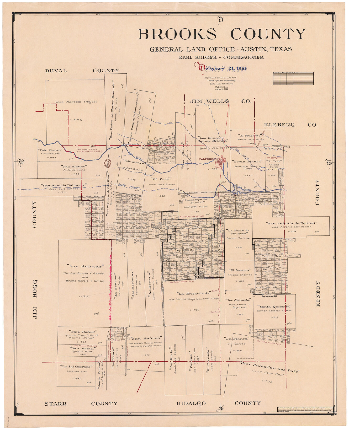
Brooks County
General Land Office Official County Map
- 
                          Map/Doc95440
- 
                            CollectionGeneral Map Collection
- 
                            Object Dates2019/8/31 (Revision Date)1955/10/31 (Creation Date)
- 
                            People and OrganizationsCheyenne Betancourt (Draftsman)Eltea Armstrong (Draftsman)R.C. Wisdom (Compiler)Earl Rudder (GLO Commissioner)
- 
                            CountiesBrooks
- 
                            SubjectsCounty OCM
- 
                            Height x Width42.6 x 34.6 inches108.2 x 87.9 cm
- 
                            Mediumdigital image
- 
                            Scale1" = 3000 varas
Part of: General Map Collection
            Hudspeth County Working Sketch 14


                                            Print $20.00                    
                                             -                         Digital $50.00                                    
                Hudspeth County Working Sketch 14
1953
Size 24.2 x 41.2 inches
                                Map/Doc 66296
            
            Cooke County Boundary File 1b


                                            Print $28.00                    
                                             -                         Digital $50.00                                    
                Cooke County Boundary File 1b
Size 12.6 x 7.4 inches
                                Map/Doc 51835
            
            Lines of Equal Magnetic Declination and of Equal Annual Change in the United States for 1930


                                            Print $20.00                    
                                             -                         Digital $50.00                                    
                Lines of Equal Magnetic Declination and of Equal Annual Change in the United States for 1930
1930
Size 23.5 x 29.7 inches
                                Map/Doc 69652
            
            Webb County Sketch File 54


                                            Print $46.00                    
                                             -                         Digital $50.00                                    
                Webb County Sketch File 54
1939
Size 11.3 x 8.8 inches
                                Map/Doc 39841
            
            Rusk County Sketch File 43


                                            Print $20.00                    
                                    
                Rusk County Sketch File 43
1951
Size 23.5 x 26.6 inches
                                Map/Doc 12278
            
            Hill County Sketch File 6


                                            Print $4.00                    
                                             -                         Digital $50.00                                    
                Hill County Sketch File 6
1848
Size 13.9 x 8.7 inches
                                Map/Doc 26470
            
            Gillespie County Sketch File 2


                                            Print $40.00                    
                                             -                         Digital $50.00                                    
                Gillespie County Sketch File 2
1847
Size 12.8 x 15.5 inches
                                Map/Doc 24127
            
            Brazoria County Sketch File 57


                                            Print $10.00                    
                                             -                         Digital $50.00                                    
                Brazoria County Sketch File 57
1940
Size 8.7 x 6.3 inches
                                Map/Doc 15377
            
            [Location, Fort Worth & Denver Railroad, through Wilbarger County]
            
                                    ![64344, [Location, Fort Worth & Denver Railroad, through Wilbarger County], General Map Collection](https://historictexasmaps.com/wmedia_w700/maps/64344.tif.jpg) 


    ![64344, [Location, Fort Worth & Denver Railroad, through Wilbarger County], General Map Collection](https://historictexasmaps.com/wmedia_w700/maps/64344.tif.jpg) 
                                
            
                                            Print $40.00                    
                                             -                         Digital $50.00                                    
                [Location, Fort Worth & Denver Railroad, through Wilbarger County]
Size 20.8 x 123.5 inches
                                Map/Doc 64344
            
            Uvalde County Working Sketch 14


                                            Print $20.00                    
                                             -                         Digital $50.00                                    
                Uvalde County Working Sketch 14
1943
Size 13.5 x 16.0 inches
                                Map/Doc 72084
            
            Limestone County Working Sketch 12


                                            Print $20.00                    
                                             -                         Digital $50.00                                    
                Limestone County Working Sketch 12
1922
Size 18.5 x 12.8 inches
                                Map/Doc 70562
            
            Galveston County NRC Article 33.136 Sketch 63


                                            Print $42.00                    
                                             -                         Digital $50.00                                    
                Galveston County NRC Article 33.136 Sketch 63
2010
Size 36.0 x 24.0 inches
                                Map/Doc 95003
            You may also like
            Railroad map of the state of Texas / compiled and engraved expressly for the American railroad manual.


                                            Print $20.00                    
                                    
                Railroad map of the state of Texas / compiled and engraved expressly for the American railroad manual.
1873
Size 13.4 x 9.5 inches
                                Map/Doc 93599
            
            Right of Way & Track Map San Antonio & Aransas Pass Railway Co.


                                            Print $40.00                    
                                             -                         Digital $50.00                                    
                Right of Way & Track Map San Antonio & Aransas Pass Railway Co.
1919
Size 25.2 x 56.7 inches
                                Map/Doc 64040
            
            Throckmorton County Working Sketch 9


                                            Print $20.00                    
                                             -                         Digital $50.00                                    
                Throckmorton County Working Sketch 9
1963
Size 25.2 x 35.8 inches
                                Map/Doc 62118
            
            McCulloch County Boundary File 3


                                            Print $16.00                    
                                             -                         Digital $50.00                                    
                McCulloch County Boundary File 3
Size 11.1 x 8.6 inches
                                Map/Doc 56911
            
            Williamson County Sketch File 13a


                                            Print $4.00                    
                                             -                         Digital $50.00                                    
                Williamson County Sketch File 13a
1871
Size 8.1 x 13.6 inches
                                Map/Doc 40330
            
            Harris County Rolled Sketch 79


                                            Print $20.00                    
                                             -                         Digital $50.00                                    
                Harris County Rolled Sketch 79
1955
Size 30.4 x 25.0 inches
                                Map/Doc 6115
            
            Live Oak County Sketch File 17


                                            Print $20.00                    
                                             -                         Digital $50.00                                    
                Live Oak County Sketch File 17
Size 24.2 x 25.4 inches
                                Map/Doc 12007
            
            [B. S. & F. Blocks 1 and 6, A. B. & M. Block 2 and surrounding surveys and blocks]
            
                                    ![91785, [B. S. & F. Blocks 1 and 6, A. B. & M. Block 2 and surrounding surveys and blocks], Twichell Survey Records](https://historictexasmaps.com/wmedia_w700/maps/91785-1.tif.jpg) 


    ![91785, [B. S. & F. Blocks 1 and 6, A. B. & M. Block 2 and surrounding surveys and blocks], Twichell Survey Records](https://historictexasmaps.com/wmedia_w700/maps/91785-1.tif.jpg) 
                                
            
                                            Print $20.00                    
                                             -                         Digital $50.00                                    
                [B. S. & F. Blocks 1 and 6, A. B. & M. Block 2 and surrounding surveys and blocks]
Size 22.6 x 33.8 inches
                                Map/Doc 91785
            
            Leon County Rolled Sketch 26


                                            Print $40.00                    
                                             -                         Digital $50.00                                    
                Leon County Rolled Sketch 26
Size 24.0 x 54.5 inches
                                Map/Doc 9435
            
            Rusk County Rolled Sketch 14


                                            Print $20.00                    
                                             -                         Digital $50.00                                    
                Rusk County Rolled Sketch 14
1997
Size 27.8 x 37.8 inches
                                Map/Doc 7549
             
                         
                                