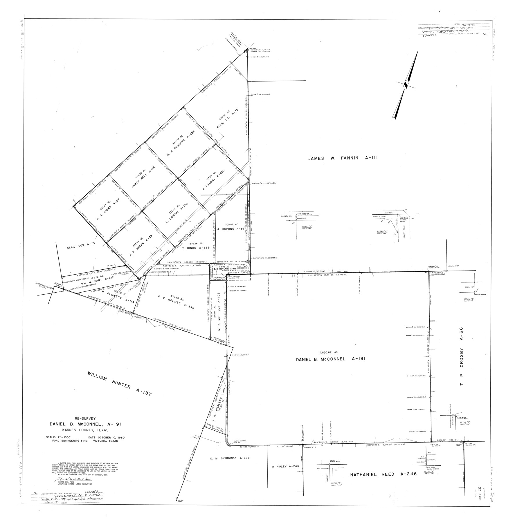
Karnes County Rolled Sketch 5
Re-survey, Daniel B. McConnel, A-191, Karnes County, Texas
-
Map/Doc
9668
-
Collection
General Map Collection
-
Object Dates
1980/10/10 (Creation Date)
1980/12/16 (File Date)
-
People and Organizations
DuWard Gail Ford (Surveyor/Engineer)
-
Counties
Karnes
-
Subjects
Surveying Rolled Sketch
-
Height x Width
40.8 x 40.2 inches
103.6 x 102.1 cm
-
Medium
mylar, print
-
Scale
1" = 1000 feet
Part of: General Map Collection
Flight Mission No. BRE-2P, Frame 82, Nueces County

Print $20.00
- Digital $50.00
Flight Mission No. BRE-2P, Frame 82, Nueces County
1956
Size 18.5 x 22.6 inches
Map/Doc 86777
Flight Mission No. BRA-16M, Frame 96, Jefferson County

Print $20.00
- Digital $50.00
Flight Mission No. BRA-16M, Frame 96, Jefferson County
1953
Size 18.6 x 22.4 inches
Map/Doc 85708
Flight Mission No. DAH-9M, Frame 198, Orange County

Print $20.00
- Digital $50.00
Flight Mission No. DAH-9M, Frame 198, Orange County
1953
Size 18.6 x 22.5 inches
Map/Doc 86866

Flight Mission No. DQO-12K, Frame 43, Galveston County

Print $20.00
- Digital $50.00
Flight Mission No. DQO-12K, Frame 43, Galveston County
1952
Size 18.6 x 22.4 inches
Map/Doc 85233
Travis County Rolled Sketch 49

Print $20.00
- Digital $50.00
Travis County Rolled Sketch 49
Size 43.0 x 39.9 inches
Map/Doc 10017
Yoakum County Sketch File 5

Print $10.00
- Digital $50.00
Yoakum County Sketch File 5
1899
Size 14.3 x 9.0 inches
Map/Doc 40733
Hale County Sketch File 22

Print $8.00
- Digital $50.00
Hale County Sketch File 22
1903
Size 11.1 x 8.6 inches
Map/Doc 24755
Flight Mission No. BRA-16M, Frame 141, Jefferson County

Print $20.00
- Digital $50.00
Flight Mission No. BRA-16M, Frame 141, Jefferson County
1953
Size 18.6 x 22.2 inches
Map/Doc 85747
[Sketch for Mineral Application 24072, San Jacinto River]
![65589, [Sketch for Mineral Application 24072, San Jacinto River], General Map Collection](https://historictexasmaps.com/wmedia_w700/maps/65589.tif.jpg)
Print $20.00
- Digital $50.00
[Sketch for Mineral Application 24072, San Jacinto River]
1929
Size 29.6 x 14.7 inches
Map/Doc 65589
Bee County Working Sketch 31a

Print $20.00
- Digital $50.00
Bee County Working Sketch 31a
1988
Size 39.5 x 43.2 inches
Map/Doc 76052
Foard County Sketch File 37

Print $4.00
- Digital $50.00
Foard County Sketch File 37
1891
Size 11.2 x 9.1 inches
Map/Doc 22869
You may also like
Map of Henderson County

Print $40.00
- Digital $50.00
Map of Henderson County
1897
Size 27.7 x 56.8 inches
Map/Doc 16849
Jefferson County Working Sketch 13

Print $20.00
- Digital $50.00
Jefferson County Working Sketch 13
1948
Size 13.5 x 20.1 inches
Map/Doc 66556
Atascosa County Rolled Sketch 15

Print $20.00
- Digital $50.00
Atascosa County Rolled Sketch 15
1945
Size 45.2 x 42.7 inches
Map/Doc 8433
Caldwell County Rolled Sketch 1

Print $20.00
- Digital $50.00
Caldwell County Rolled Sketch 1
1953
Size 20.2 x 30.4 inches
Map/Doc 10673
[I. M. Bolton, L. S. Thacker, and R. C. Poteet Subdivisions]
![92579, [I. M. Bolton, L. S. Thacker, and R. C. Poteet Subdivisions], Twichell Survey Records](https://historictexasmaps.com/wmedia_w700/maps/92579-1.tif.jpg)
Print $20.00
- Digital $50.00
[I. M. Bolton, L. S. Thacker, and R. C. Poteet Subdivisions]
1924
Size 18.3 x 24.8 inches
Map/Doc 92579
Terrell County Sketch File 19

Print $6.00
- Digital $50.00
Terrell County Sketch File 19
1910
Size 10.2 x 12.1 inches
Map/Doc 37944

Map of a Route from Austin-City to Paso del Norte & c.

Print $20.00
- Digital $50.00
Map of a Route from Austin-City to Paso del Norte & c.
1849
Size 11.7 x 30.5 inches
Map/Doc 2121
Throckmorton County Sketch File 8

Print $66.00
- Digital $50.00
Throckmorton County Sketch File 8
Size 24.0 x 32.4 inches
Map/Doc 12433
San Patricio County Rolled Sketch 46A

Print $2.00
- Digital $50.00
San Patricio County Rolled Sketch 46A
1983
Size 8.3 x 10.3 inches
Map/Doc 8372
Crockett County Working Sketch 55

Print $40.00
- Digital $50.00
Crockett County Working Sketch 55
1951
Size 51.0 x 37.5 inches
Map/Doc 68388
[Ferguson State Farm]
![62991, [Ferguson State Farm], General Map Collection](https://historictexasmaps.com/wmedia_w700/maps/62991.tif.jpg)
Print $20.00
- Digital $50.00
[Ferguson State Farm]
Size 17.2 x 16.1 inches
Map/Doc 62991