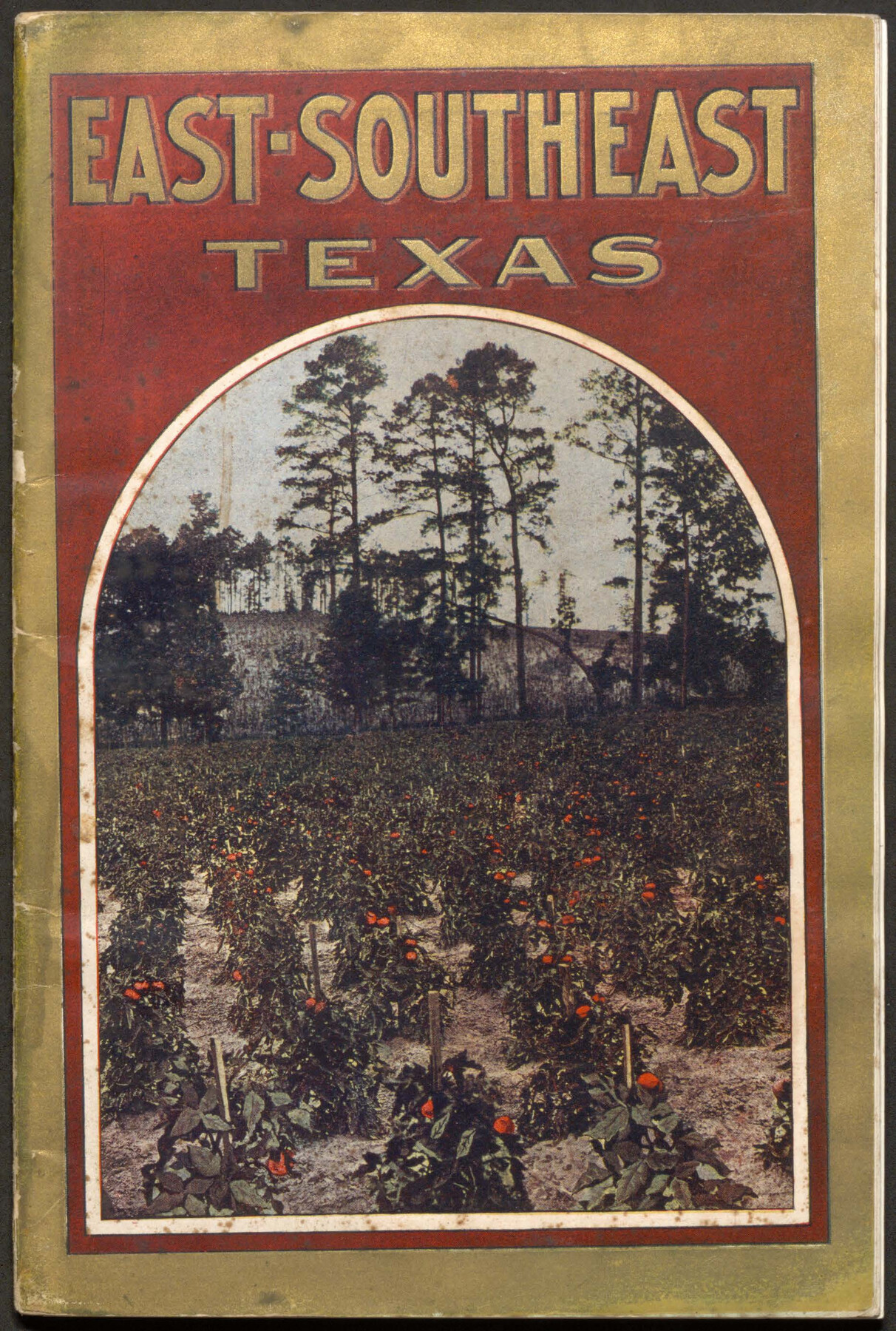
East-Southeast Texas
- 
                          Map/Doc96717
- 
                            CollectionCobb Digital Map Collection
- 
                            Object Dates[1912] (Creation Date)
- 
                            People and OrganizationsPassenger Department, Sunset-Central Lines (Publisher)
- 
                            SubjectsRailroads Bound Volume
- 
                            Mediumpdf
- 
                            CommentsCourtesy of John & Diana Cobb.
Part of: Cobb Digital Map Collection
            The Texas and Oklahoma Official Railway & Hotel Guide Map


                                            Print $20.00                    
                                             -                         Digital $50.00                                    
                The Texas and Oklahoma Official Railway & Hotel Guide Map
1906
Size 23.4 x 23.7 inches
                                Map/Doc 95892
            
            The M. K. and T., Missouri, Kansas & Texas Railway


                                            Print $20.00                    
                                             -                         Digital $50.00                                    
                The M. K. and T., Missouri, Kansas & Texas Railway
1890
Size 25.0 x 27.9 inches
                                Map/Doc 95807
            
            Shallow Water Country of Northwest Texas


            Shallow Water Country of Northwest Texas
1916
Map/Doc 96758
            
            Map of the Southern Pacific and connecting lines


                                            Print $20.00                    
                                             -                         Digital $50.00                                    
                Map of the Southern Pacific and connecting lines
1897
Size 8.7 x 15.9 inches
                                Map/Doc 95763
            
            The Lower Valley of the Rio Grande Irrigated Farm Lands


                                            Print $20.00                    
                                             -                         Digital $50.00                                    
                The Lower Valley of the Rio Grande Irrigated Farm Lands
1918
Size 24.5 x 18.7 inches
                                Map/Doc 96730
            
            Sectional Map of Texas


                                            Print $20.00                    
                                             -                         Digital $50.00                                    
                Sectional Map of Texas
1909
Size 21.8 x 23.0 inches
                                Map/Doc 95799
            
            Santa Rosa, the Saint of Roses - Lower Rio Grande Valley


            Santa Rosa, the Saint of Roses - Lower Rio Grande Valley
1920
Map/Doc 96734
            
            [Plat map of Provident City and surrounding] / Map showing the Gulf Coast Country and Railways and Water Shipping Facilities of the Provident Land Tract
            
                                    ![95819, [Plat map of Provident City and surrounding] / Map showing the Gulf Coast Country and Railways and Water Shipping Facilities of the Provident Land Tract, Cobb Digital Map Collection](https://historictexasmaps.com/wmedia_w700/maps/95819.tif.jpg) 


    ![95819, [Plat map of Provident City and surrounding] / Map showing the Gulf Coast Country and Railways and Water Shipping Facilities of the Provident Land Tract, Cobb Digital Map Collection](https://historictexasmaps.com/wmedia_w700/maps/95819.tif.jpg) 
                                
            
                                            Print $20.00                    
                                             -                         Digital $50.00                                    
                [Plat map of Provident City and surrounding] / Map showing the Gulf Coast Country and Railways and Water Shipping Facilities of the Provident Land Tract
1908
Size 22.0 x 22.9 inches
                                Map/Doc 95819
            
            The Magic Valley of the Lower Rio Grande


            The Magic Valley of the Lower Rio Grande
1926
Map/Doc 96733
            
            The Rand McNally New Commercial Atlas Map of Texas


                                            Print $20.00                    
                                             -                         Digital $50.00                                    
                The Rand McNally New Commercial Atlas Map of Texas
1914
Size 28.6 x 40.2 inches
                                Map/Doc 95849
            You may also like
            The Republic County of Matagorda. 1841


                                            Print $20.00                    
                                    
                The Republic County of Matagorda. 1841
2020
Size 21.0 x 21.7 inches
                                Map/Doc 96219
            
            Delta County Sketch File 1a


                                            Print $4.00                    
                                             -                         Digital $50.00                                    
                Delta County Sketch File 1a
Size 8.3 x 8.9 inches
                                Map/Doc 20668
            
            Winkler County


                                            Print $20.00                    
                                             -                         Digital $50.00                                    
                Winkler County
1932
Size 39.4 x 39.5 inches
                                Map/Doc 63132
            
            [Sketch showing Northwest corner of Fisher County, Northeast corner of Scurry County and South part of Kent County]
            
                                    ![90917, [Sketch showing Northwest corner of Fisher County, Northeast corner of Scurry County and South part of Kent County], Twichell Survey Records](https://historictexasmaps.com/wmedia_w700/maps/90917-1.tif.jpg) 


    ![90917, [Sketch showing Northwest corner of Fisher County, Northeast corner of Scurry County and South part of Kent County], Twichell Survey Records](https://historictexasmaps.com/wmedia_w700/maps/90917-1.tif.jpg) 
                                
            
                                            Print $20.00                    
                                             -                         Digital $50.00                                    
                [Sketch showing Northwest corner of Fisher County, Northeast corner of Scurry County and South part of Kent County]
1900
Size 17.7 x 15.0 inches
                                Map/Doc 90917
            
            [The S.K. Ry. of Texas, State Line to Pecos, Reeves Co., Texas]
            
                                    ![64161, [The S.K. Ry. of Texas, State Line to Pecos, Reeves Co., Texas], General Map Collection](https://historictexasmaps.com/wmedia_w700/maps/64161.tif.jpg) 


    ![64161, [The S.K. Ry. of Texas, State Line to Pecos, Reeves Co., Texas], General Map Collection](https://historictexasmaps.com/wmedia_w700/maps/64161.tif.jpg) 
                                
            
                                            Print $40.00                    
                                             -                         Digital $50.00                                    
                [The S.K. Ry. of Texas, State Line to Pecos, Reeves Co., Texas]
1910
Size 19.2 x 120.9 inches
                                Map/Doc 64161
            
            Throckmorton County Rolled Sketch 3B


                                            Print $20.00                    
                                             -                         Digital $50.00                                    
                Throckmorton County Rolled Sketch 3B
Size 31.3 x 37.9 inches
                                Map/Doc 7988
            
            Mosaic composed of aerial photographs - Houston Ship Channel, Tex.


                                            Print $20.00                    
                                             -                         Digital $50.00                                    
                Mosaic composed of aerial photographs - Houston Ship Channel, Tex.
1923
Size 13.7 x 38.0 inches
                                Map/Doc 97172
            
            Leon County Sketch File 6


                                            Print $4.00                    
                                             -                         Digital $50.00                                    
                Leon County Sketch File 6
1859
Size 8.2 x 12.0 inches
                                Map/Doc 29719
            
            General Highway Map, Hardeman County, Texas


                                            Print $20.00                    
                                    
                General Highway Map, Hardeman County, Texas
1940
Size 25.0 x 18.3 inches
                                Map/Doc 79113
            
            Callahan County Sketch File 2


                                            Print $8.00                    
                                             -                         Digital $50.00                                    
                Callahan County Sketch File 2
1858
Size 11.8 x 8.7 inches
                                Map/Doc 35853
            
            Pecos County Rolled Sketch 159


                                            Print $46.00                    
                                             -                         Digital $50.00                                    
                Pecos County Rolled Sketch 159
1964
Size 31.9 x 38.3 inches
                                Map/Doc 7285


                                