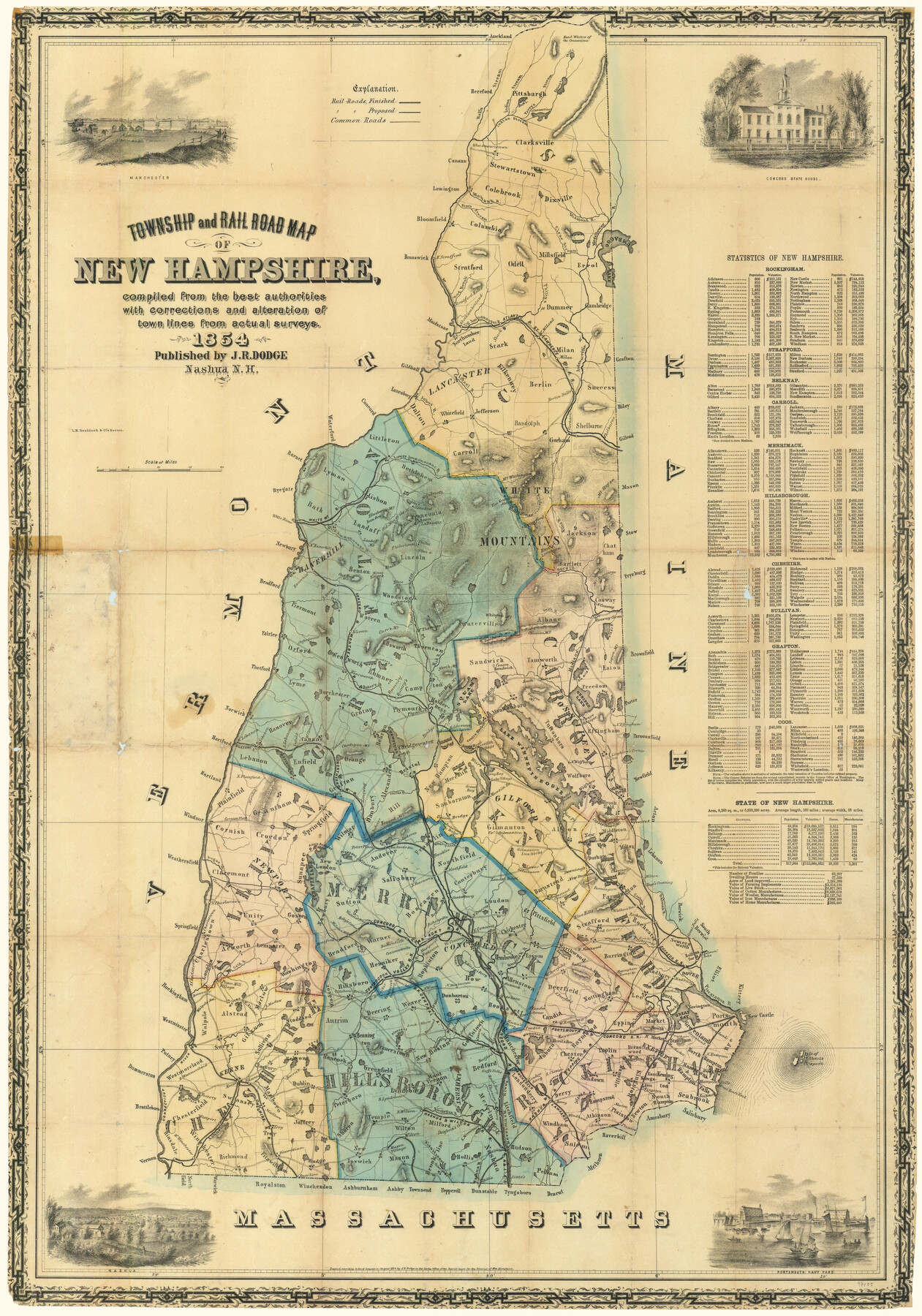
Township and Railroad Map of New Hampshire compiled from the best authorities with corrections and alteration of town lines from actual surveys
-
Map/Doc
97105
-
Collection
General Map Collection
-
Object Dates
1854 (Creation Date)
-
People and Organizations
Jeff Bohm (Donor)
L.H. Bradford & Co. (Printer)
J.R. Dodge (Publisher)
-
Height x Width
34.8 x 24.4 inches
88.4 x 62.0 cm
-
Medium
paper, etching/engraving/lithograph
-
Comments
Donated by Jeff Bohm in February, 2023.
To view cover in which this map was contained, click "Download PDF" link above.
Part of: General Map Collection
Kinney County Working Sketch 1

Print $20.00
- Digital $50.00
Kinney County Working Sketch 1
Size 22.6 x 24.0 inches
Map/Doc 70183
Cass County Working Sketch 19

Print $20.00
- Digital $50.00
Cass County Working Sketch 19
1959
Size 27.2 x 29.3 inches
Map/Doc 67922
Harris County Sketch File 92

Print $20.00
- Digital $50.00
Harris County Sketch File 92
1932
Size 37.9 x 35.0 inches
Map/Doc 10483
Texas City Channel, Texas, Channel and Turning Basin Dredging - Sheet 1

Print $20.00
- Digital $50.00
Texas City Channel, Texas, Channel and Turning Basin Dredging - Sheet 1
1958
Size 29.3 x 40.8 inches
Map/Doc 61831
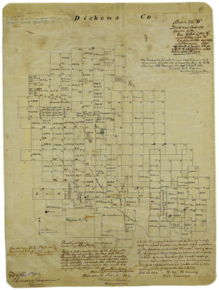
Dickens County Rolled Sketch H
Print $20.00
- Digital $50.00
Dickens County Rolled Sketch H
1902
Size 26.4 x 19.1 inches
Map/Doc 5712
Coleman County Sketch File 22

Print $10.00
- Digital $50.00
Coleman County Sketch File 22
1871
Size 8.4 x 7.9 inches
Map/Doc 18698
Jones County Sketch File 19

Print $56.00
- Digital $50.00
Jones County Sketch File 19
1875
Size 11.1 x 8.6 inches
Map/Doc 28516
Edwards County Sketch File 38

Print $22.00
- Digital $50.00
Edwards County Sketch File 38
1937
Size 11.2 x 8.6 inches
Map/Doc 21773
Boundary Between the United States & Mexico Agreed Upon by the Joint Commission under the Treaty of Guadalupe Hidalgo

Print $4.00
- Digital $50.00
Boundary Between the United States & Mexico Agreed Upon by the Joint Commission under the Treaty of Guadalupe Hidalgo
1853
Size 24.0 x 17.6 inches
Map/Doc 65391
Edwards County Working Sketch 73

Print $20.00
- Digital $50.00
Edwards County Working Sketch 73
1958
Size 30.4 x 27.0 inches
Map/Doc 68949
Brazoria County Working Sketch Graphic Index

Print $20.00
- Digital $50.00
Brazoria County Working Sketch Graphic Index
1947
Size 41.0 x 38.1 inches
Map/Doc 76471
Upton County Working Sketch 43

Print $40.00
- Digital $50.00
Upton County Working Sketch 43
1962
Size 56.8 x 42.7 inches
Map/Doc 69539
You may also like
Louisiana and Texas Intracoastal Waterway Proposed Extension to Rio Grande Valley

Print $20.00
- Digital $50.00
Louisiana and Texas Intracoastal Waterway Proposed Extension to Rio Grande Valley
1941
Size 28.1 x 41.1 inches
Map/Doc 61891

Sutton County Sketch File J

Print $4.00
- Digital $50.00
Sutton County Sketch File J
Size 14.5 x 8.8 inches
Map/Doc 37505
St Francis situated in Potter and Carson Counties, Texas

Print $20.00
- Digital $50.00
St Francis situated in Potter and Carson Counties, Texas
Size 22.0 x 26.1 inches
Map/Doc 93109
Flight Mission No. DQO-2K, Frame 91, Galveston County

Print $20.00
- Digital $50.00
Flight Mission No. DQO-2K, Frame 91, Galveston County
1952
Size 18.8 x 22.5 inches
Map/Doc 85018
General Highway Map. Detail of Cities and Towns in Collin County, Texas

Print $20.00
General Highway Map. Detail of Cities and Towns in Collin County, Texas
1961
Size 18.2 x 24.8 inches
Map/Doc 79414
Mitchell County Sketch File 11

Print $6.00
- Digital $50.00
Mitchell County Sketch File 11
1910
Size 11.2 x 8.8 inches
Map/Doc 31700
Flight Mission No. BRA-6M, Frame 91, Jefferson County

Print $20.00
- Digital $50.00
Flight Mission No. BRA-6M, Frame 91, Jefferson County
1953
Size 18.5 x 22.4 inches
Map/Doc 85434
[Blocks Surrounding I. G. Yates Section 34 1/2]
![92442, [Blocks Surrounding I. G. Yates Section 34 1/2], Twichell Survey Records](https://historictexasmaps.com/wmedia_w700/maps/92442-1.tif.jpg)
Print $20.00
- Digital $50.00
[Blocks Surrounding I. G. Yates Section 34 1/2]
Size 41.9 x 11.3 inches
Map/Doc 92442
San Jacinto County Working Sketch 45

Print $20.00
- Digital $50.00
San Jacinto County Working Sketch 45
1986
Size 41.0 x 46.7 inches
Map/Doc 63759
Tracing "A" [showing Rio Grande and settlements along river]
![72888, Tracing "A" [showing Rio Grande and settlements along river], General Map Collection](https://historictexasmaps.com/wmedia_w700/maps/72888.tif.jpg)
Print $20.00
- Digital $50.00
Tracing "A" [showing Rio Grande and settlements along river]
1881
Size 18.2 x 25.9 inches
Map/Doc 72888
Runnels County Sketch File 40

Print $20.00
Runnels County Sketch File 40
1891
Size 37.7 x 14.3 inches
Map/Doc 10594