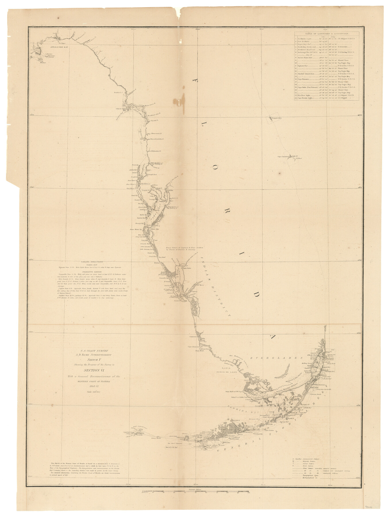
Sketch F Showing the Progress of the Survey in Section VI With a General Reconnoissance of the Western Coast of Florida
-
Map/Doc
97216
-
Collection
General Map Collection
-
Object Dates
1848-1852 (Creation Date)
-
People and Organizations
A.D. Bache (Superintendent)
U.S. Coast Survey (Publisher)
-
Height x Width
25.5 x 19.2 inches
64.8 x 48.8 cm
-
Comments
Sketch from the book "Report of the Superintendent of the Coast Survey Showing the Progress of the Survey in the year 1852" (81738)
Related maps
Report of the Superintendent of the Coast Survey showing the progress of the survey during the year 1852

Report of the Superintendent of the Coast Survey showing the progress of the survey during the year 1852
1853
Map/Doc 81738
Part of: General Map Collection
Reagan County Sketch File 3

Print $20.00
- Digital $50.00
Reagan County Sketch File 3
Size 18.0 x 21.9 inches
Map/Doc 12213
Ellis County Sketch File 18

Print $40.00
- Digital $50.00
Ellis County Sketch File 18
Size 16.0 x 12.8 inches
Map/Doc 21862
Upton County Sketch File 25

Print $20.00
- Digital $50.00
Upton County Sketch File 25
1928
Size 27.1 x 44.4 inches
Map/Doc 10415
Tom Green County Sketch File 79A

Print $4.00
- Digital $50.00
Tom Green County Sketch File 79A
1970
Size 14.5 x 8.8 inches
Map/Doc 38258
The Texas & Oklahoma Official Railway & Hotel Guide Map

Print $20.00
- Digital $50.00
The Texas & Oklahoma Official Railway & Hotel Guide Map
1917
Size 23.6 x 24.1 inches
Map/Doc 94032
Howard County Boundary File 3

Print $51.00
- Digital $50.00
Howard County Boundary File 3
Size 9.3 x 4.5 inches
Map/Doc 55130
Real County Working Sketch 70

Print $20.00
- Digital $50.00
Real County Working Sketch 70
1976
Size 32.3 x 31.8 inches
Map/Doc 71962
Palo Pinto County Sketch File 4

Print $4.00
- Digital $50.00
Palo Pinto County Sketch File 4
1870
Size 8.2 x 12.9 inches
Map/Doc 33394
Webb County Working Sketch 8

Print $20.00
- Digital $50.00
Webb County Working Sketch 8
1911
Size 43.1 x 39.9 inches
Map/Doc 72373
St. L. S-W. Ry. of Texas Map of Lufkin Branch in Cherokee County Texas

Print $40.00
- Digital $50.00
St. L. S-W. Ry. of Texas Map of Lufkin Branch in Cherokee County Texas
1912
Size 22.7 x 64.3 inches
Map/Doc 64019
Webb County Rolled Sketch 54

Print $20.00
- Digital $50.00
Webb County Rolled Sketch 54
1935
Size 24.8 x 18.6 inches
Map/Doc 8207
Maps & Lists Showing Prison Lands (Oil & Gas) Leased as of June 1955

Digital $50.00
Maps & Lists Showing Prison Lands (Oil & Gas) Leased as of June 1955
1930
Size 24.4 x 26.8 inches
Map/Doc 62876
You may also like
Translations & Index to Field Notes of Spanish Titles, Vol. 2 (Jackson - Wood Counties)

Translations & Index to Field Notes of Spanish Titles, Vol. 2 (Jackson - Wood Counties)
Map/Doc 94552
Flight Mission No. BRA-16M, Frame 149, Jefferson County

Print $20.00
- Digital $50.00
Flight Mission No. BRA-16M, Frame 149, Jefferson County
1953
Size 18.6 x 22.3 inches
Map/Doc 85755
[H. & T. C. 47, Sections 57- 61] / [Blocks 4 and 6]
![91417, [H. & T. C. 47, Sections 57- 61] / [Blocks 4 and 6], Twichell Survey Records](https://historictexasmaps.com/wmedia_w700/maps/91417-1.tif.jpg)
Print $20.00
- Digital $50.00
[H. & T. C. 47, Sections 57- 61] / [Blocks 4 and 6]
Size 25.9 x 19.5 inches
Map/Doc 91417
Coast Chart No. 212 - From Latitude 26° 33' to the Rio Grande Texas

Print $20.00
- Digital $50.00
Coast Chart No. 212 - From Latitude 26° 33' to the Rio Grande Texas
1886
Size 27.2 x 18.2 inches
Map/Doc 72830
Newton County Rolled Sketch 19

Print $20.00
- Digital $50.00
Newton County Rolled Sketch 19
1956
Size 42.1 x 33.5 inches
Map/Doc 6848
Working Sketch Dickens and Kent Counties

Print $20.00
- Digital $50.00
Working Sketch Dickens and Kent Counties
1904
Size 16.3 x 20.7 inches
Map/Doc 90862
Cass County Working Sketch 25

Print $20.00
- Digital $50.00
Cass County Working Sketch 25
1974
Size 46.5 x 35.8 inches
Map/Doc 67928
General Highway Map, Bailey County, Texas

Print $20.00
General Highway Map, Bailey County, Texas
1961
Size 25.0 x 18.2 inches
Map/Doc 79359
Leon County Boundary File 1

Print $34.00
- Digital $50.00
Leon County Boundary File 1
Size 21.0 x 6.6 inches
Map/Doc 56281
Campbell's Addition to El Paso, Texas

Print $20.00
- Digital $50.00
Campbell's Addition to El Paso, Texas
1885
Size 43.5 x 43.1 inches
Map/Doc 8854
Val Verde County Working Sketch 53

Print $20.00
- Digital $50.00
Val Verde County Working Sketch 53
1956
Size 42.8 x 47.7 inches
Map/Doc 72188
Intracoastal Waterway in Texas - Corpus Christi to Point Isabel including Arroyo Colorado to Mo. Pac. R.R. Bridge Near Harlingen

Print $20.00
- Digital $50.00
Intracoastal Waterway in Texas - Corpus Christi to Point Isabel including Arroyo Colorado to Mo. Pac. R.R. Bridge Near Harlingen
1933
Size 27.9 x 40.8 inches
Map/Doc 61862