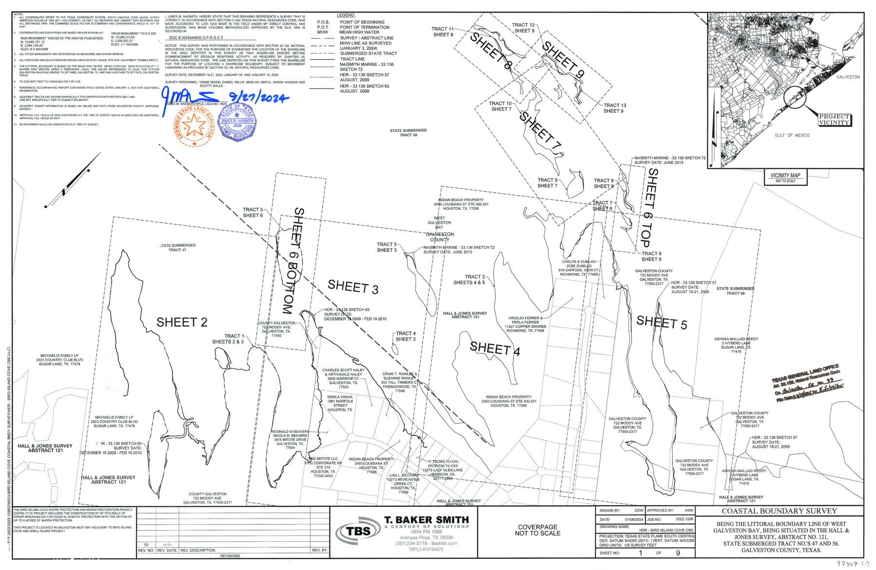
Galveston County NRC Article 33.136 Sketch 97
Coastal Boundary Survey being the littoral boundary line along the Mean High Water lines of West Bay, being a portion of the boundary lines of the Hall & Jones Survey, Abstract No. 121, West Bay, and State submerged tract nos. 47 and 56.
-
Map/Doc
97407
-
Collection
General Map Collection
-
Object Dates
9/27/2024 (Creation Date)
2/10/2025 (File Date)
-
People and Organizations
James M. Naismith (Surveyor/Engineer)
-
Counties
Galveston
-
Subjects
Surveying CBS
-
Comments
Project: Bird Island Cove Hall and Jones Survey
Project No.: CEPRA Project No. 1713
A copy of the survey has been filed under Instrument No. 2024044600, Official Public Records of Galveston Co., Texas.
Part of: General Map Collection
Gillespie County Sketch File 17

Print $8.00
- Digital $50.00
Gillespie County Sketch File 17
1994
Size 11.2 x 8.7 inches
Map/Doc 24157
Hunt County Working Sketch 11

Print $20.00
- Digital $50.00
Hunt County Working Sketch 11
2002
Size 32.1 x 29.6 inches
Map/Doc 66358
Right of Way and Track Map Texas & New Orleans R.R. Co. operated by the T. & N. O. R.R. Co. Dallas-Sabine Branch

Print $40.00
- Digital $50.00
Right of Way and Track Map Texas & New Orleans R.R. Co. operated by the T. & N. O. R.R. Co. Dallas-Sabine Branch
1918
Size 26.1 x 56.7 inches
Map/Doc 64150
Brooks County Working Sketch 4

Print $20.00
- Digital $50.00
Brooks County Working Sketch 4
1906
Size 28.6 x 24.9 inches
Map/Doc 67788
Hardin County Working Sketch 26

Print $20.00
- Digital $50.00
Hardin County Working Sketch 26
1954
Size 19.5 x 23.8 inches
Map/Doc 63424
Harris County Historic Topographic 5

Print $20.00
- Digital $50.00
Harris County Historic Topographic 5
1916
Size 29.2 x 22.8 inches
Map/Doc 65815
Pecos County Working Sketch 19

Print $20.00
- Digital $50.00
Pecos County Working Sketch 19
1917
Size 21.0 x 14.6 inches
Map/Doc 71489
Brewster County Rolled Sketch 114

Print $20.00
- Digital $50.00
Brewster County Rolled Sketch 114
1964
Size 11.7 x 18.3 inches
Map/Doc 5276
Boundary Between the United States & Mexico Agreed Upon by the Joint Commission under the Treaty of Guadalupe Hidalgo

Print $4.00
- Digital $50.00
Boundary Between the United States & Mexico Agreed Upon by the Joint Commission under the Treaty of Guadalupe Hidalgo
1853
Size 24.9 x 18.1 inches
Map/Doc 65393
Galveston County NRC Article 33.136 Sketch 14

Print $20.00
- Digital $50.00
Galveston County NRC Article 33.136 Sketch 14
2002
Size 24.0 x 34.3 inches
Map/Doc 77045
Brewster County Rolled Sketch 115

Print $40.00
- Digital $50.00
Brewster County Rolled Sketch 115
1958
Size 11.5 x 138.4 inches
Map/Doc 8514
Carta Etnografica

Print $20.00
- Digital $50.00
Carta Etnografica
1897
Size 26.2 x 34.1 inches
Map/Doc 96798
You may also like
Reagan County Rolled Sketch 34

Print $40.00
- Digital $50.00
Reagan County Rolled Sketch 34
1956
Size 53.2 x 40.3 inches
Map/Doc 9829
Flight Mission No. BQR-9K, Frame 47, Brazoria County

Print $20.00
- Digital $50.00
Flight Mission No. BQR-9K, Frame 47, Brazoria County
1952
Size 18.7 x 22.4 inches
Map/Doc 84051
Baylor County Sketch File 17

Print $4.00
- Digital $50.00
Baylor County Sketch File 17
1872
Size 12.8 x 8.5 inches
Map/Doc 14189
Houston County Working Sketch 14

Print $20.00
- Digital $50.00
Houston County Working Sketch 14
1957
Size 35.1 x 24.0 inches
Map/Doc 66244
Newton County Sketch File 7

Print $4.00
- Digital $50.00
Newton County Sketch File 7
1872
Size 6.1 x 8.3 inches
Map/Doc 32374
Map of Nacogdoches County

Print $20.00
- Digital $50.00
Map of Nacogdoches County
1881
Size 24.1 x 21.5 inches
Map/Doc 4605
Galveston Bay and Approaches

Print $20.00
- Digital $50.00
Galveston Bay and Approaches
1924
Size 45.5 x 34.0 inches
Map/Doc 69873
Freestone County Sketch File 10

Print $40.00
- Digital $50.00
Freestone County Sketch File 10
Size 13.0 x 13.5 inches
Map/Doc 23058
The Republic County of Colorado. December 29, 1845

Print $20.00
The Republic County of Colorado. December 29, 1845
2020
Size 18.4 x 21.7 inches
Map/Doc 96127
Bandera County Boundary File 6

Print $42.00
- Digital $50.00
Bandera County Boundary File 6
1972
Size 14.2 x 8.9 inches
Map/Doc 50303
Map Showing the position of surveys 1 & 2, B.S. & F. Cert 1/356

Print $20.00
- Digital $50.00
Map Showing the position of surveys 1 & 2, B.S. & F. Cert 1/356
1915
Size 22.0 x 11.1 inches
Map/Doc 10768
Webb County Sketch File 44b-1

Print $20.00
- Digital $50.00
Webb County Sketch File 44b-1
1936
Size 29.0 x 18.0 inches
Map/Doc 12641