[Map of the Texas & Pacific Railway and connections]
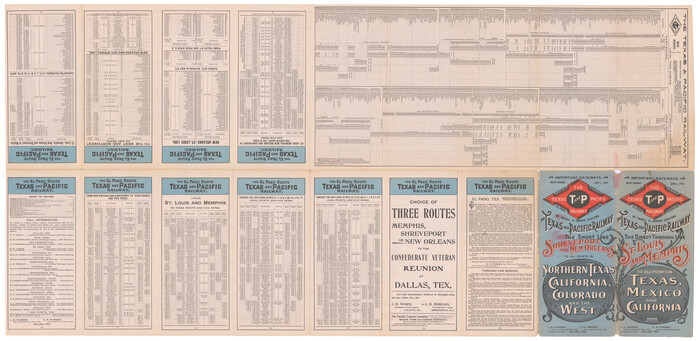
Print $20.00
- Digital $50.00
[Map of the Texas & Pacific Railway and connections]
1902
Size: 18.0 x 37.0 inches
95414
Traveller's Map of the State of Texas

Print $20.00
- Digital $50.00
Traveller's Map of the State of Texas
1867
Size: 43.4 x 41.6 inches
93906
Trace d'une partie Chemin de Fer de Galveston à Houston et Henderson, Texas, Etats unis d'Amérique

Print $20.00
- Digital $50.00
Trace d'une partie Chemin de Fer de Galveston à Houston et Henderson, Texas, Etats unis d'Amérique
1857
Size: 17.1 x 21.8 inches
93905
Topographisch-geognostische Karte von Texas mit Zugrundelegung der geographischen Karte v. Wilson nach eigenen Beobachtungen bearbeitet von Dr. Ferd. Roemer

Print $20.00
- Digital $50.00
Topographisch-geognostische Karte von Texas mit Zugrundelegung der geographischen Karte v. Wilson nach eigenen Beobachtungen bearbeitet von Dr. Ferd. Roemer
1849
Size: 24.5 x 21.0 inches
94099
The State of Texas

Print $20.00
- Digital $50.00
The State of Texas
1845
Size: 18.9 x 23.2 inches
93870
The Scarborough Company's New Railroad, Post Office & County Map of Texas, Oklahoma and Indian Territory Compiled from the Latest Government Surveys and Original Sources

Print $20.00
- Digital $50.00
The Scarborough Company's New Railroad, Post Office & County Map of Texas, Oklahoma and Indian Territory Compiled from the Latest Government Surveys and Original Sources
1904
Size: 42.8 x 46.6 inches
93911
The North Part of America

Print $20.00
- Digital $50.00
The North Part of America
1625
Size: 13.1 x 14.8 inches
93815
The History of the Republic of Texas, from the discovery of the country to the present time; and the cause of her separation from the Republic of Mexico.

Print $1080.00
- Digital $50.00
The History of the Republic of Texas, from the discovery of the country to the present time; and the cause of her separation from the Republic of Mexico.
1842
Size: 9.3 x 6.1 inches
93866
The History of Texas; or, the Emigrants, Farmer's, and Politician's Guide to the Character, Climate, Soil and Productions of that Country; geographically arranged from personal observation and experience.

Print $692.00
- Digital $50.00
The History of Texas; or, the Emigrants, Farmer's, and Politician's Guide to the Character, Climate, Soil and Productions of that Country; geographically arranged from personal observation and experience.
1836
Size: 8.1 x 5.3 inches
93856
The Flags of the Principal Nations in the World
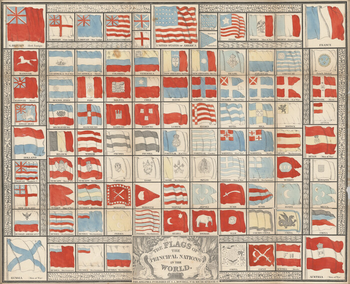
Print $20.00
- Digital $50.00
The Flags of the Principal Nations in the World
1845
Size: 18.3 x 22.6 inches
97533
Texas, Oregon and California [Cover and accompaniment]
![93873, Texas, Oregon and California [Cover and accompaniment], Holcomb Digital Map Collection](https://historictexasmaps.com/wmedia_w700/pdf_converted_jpg/qi_pdf_thumbnail_38543.jpg)
Print $108.00
- Digital $50.00
Texas, Oregon and California [Cover and accompaniment]
1846
Size: 5.4 x 3.4 inches
93873
Texas compiled from the latest and best authorities

Print $20.00
- Digital $50.00
Texas compiled from the latest and best authorities
1842
Size: 11.8 x 14.0 inches
93864
Texas Nach den besten Quellen

Print $20.00
- Digital $50.00
Texas Nach den besten Quellen
1846
Size: 15.4 x 18.7 inches
93874
Terre Nove (verso)

Print $20.00
- Digital $50.00
Terre Nove (verso)
1522
Size: 12.2 x 7.8 inches
93802
Tanner's Travelling Map of Mexico

Print $2.00
- Digital $50.00
Tanner's Travelling Map of Mexico
1847
Size: 6.2 x 4.1 inches
93877
Tabula Terre Nove

Print $20.00
- Digital $50.00
Tabula Terre Nove
1513
Size: 18.7 x 24.6 inches
93800
Smith's Atlas designed to accompany the Geography

Print $352.00
- Digital $50.00
Smith's Atlas designed to accompany the Geography
1850
Size: 12.2 x 10.0 inches
93881
Richardson's New Map of the State of Texas, corrected for the Texas Almanac to 1872

Print $20.00
- Digital $50.00
Richardson's New Map of the State of Texas, corrected for the Texas Almanac to 1872
1872
Size: 19.2 x 26.6 inches
97525
Richardson's New Map of the State of Texas Including Part of Mexico Compiled From Government Surveys and Other Authentic Documents

Print $20.00
- Digital $50.00
Richardson's New Map of the State of Texas Including Part of Mexico Compiled From Government Surveys and Other Authentic Documents
1860
Size: 28.5 x 36.3 inches
96788
Reynolds's Political Map of the United States Designed to Exhibit the Comparative Area of the Free and Slave States and the Territory open to Slavery or Freedom by the Repeal of the Missouri Compromise

Print $20.00
- Digital $50.00
Reynolds's Political Map of the United States Designed to Exhibit the Comparative Area of the Free and Slave States and the Territory open to Slavery or Freedom by the Repeal of the Missouri Compromise
1856
Size: 24.0 x 27.0 inches
97115
Qvivirae Regnv, cum alijs verfus Borea

Print $20.00
- Digital $50.00
Qvivirae Regnv, cum alijs verfus Borea
1593
Size: 16.7 x 11.7 inches
93833
Qvarte Partie Dv Monde

Print $20.00
- Digital $50.00
Qvarte Partie Dv Monde
1575
Size: 15.3 x 18.9 inches
93806
Pressler's Map of the State of Texas

Print $40.00
- Digital $50.00
Pressler's Map of the State of Texas
1862
Size: 48.0 x 52.7 inches
95714
Pressler's Map of Texas

Print $2.00
- Digital $50.00
Pressler's Map of Texas
1867
Size: 9.0 x 6.0 inches
93920
Perry and Spaulding's American Republic and Railroad Map of the United States and of the Dominion of Canada

Print $40.00
- Digital $50.00
Perry and Spaulding's American Republic and Railroad Map of the United States and of the Dominion of Canada
1874
Size: 40.5 x 55.7 inches
93913
Nuevo Mapa Geographico de la America Septentrional, Perteneciente al Virreynato de Mexico

Print $20.00
- Digital $50.00
Nuevo Mapa Geographico de la America Septentrional, Perteneciente al Virreynato de Mexico
1768
Size: 23.1 x 30.3 inches
93835
[Map of the Texas & Pacific Railway and connections]
Print $20.00
- Digital $50.00
[Map of the Texas & Pacific Railway and connections]
1902
-
Size
18.0 x 37.0 inches
-
Map/Doc
95414
-
Creation Date
1902
Traveller's Map of the State of Texas
Print $20.00
- Digital $50.00
Traveller's Map of the State of Texas
1867
-
Size
43.4 x 41.6 inches
-
Map/Doc
93906
-
Creation Date
1867
Trace d'une partie Chemin de Fer de Galveston à Houston et Henderson, Texas, Etats unis d'Amérique
Print $20.00
- Digital $50.00
Trace d'une partie Chemin de Fer de Galveston à Houston et Henderson, Texas, Etats unis d'Amérique
1857
-
Size
17.1 x 21.8 inches
-
Map/Doc
93905
-
Creation Date
1857
Topographisch-geognostische Karte von Texas mit Zugrundelegung der geographischen Karte v. Wilson nach eigenen Beobachtungen bearbeitet von Dr. Ferd. Roemer
Print $20.00
- Digital $50.00
Topographisch-geognostische Karte von Texas mit Zugrundelegung der geographischen Karte v. Wilson nach eigenen Beobachtungen bearbeitet von Dr. Ferd. Roemer
1849
-
Size
24.5 x 21.0 inches
-
Map/Doc
94099
-
Creation Date
1849
The State of Texas
Print $20.00
- Digital $50.00
The State of Texas
1845
-
Size
18.9 x 23.2 inches
-
Map/Doc
93870
-
Creation Date
1845
The Scarborough Company's New Railroad, Post Office & County Map of Texas, Oklahoma and Indian Territory Compiled from the Latest Government Surveys and Original Sources
Print $20.00
- Digital $50.00
The Scarborough Company's New Railroad, Post Office & County Map of Texas, Oklahoma and Indian Territory Compiled from the Latest Government Surveys and Original Sources
1904
-
Size
42.8 x 46.6 inches
-
Map/Doc
93911
-
Creation Date
1904
The North Part of America
Print $20.00
- Digital $50.00
The North Part of America
1625
-
Size
13.1 x 14.8 inches
-
Map/Doc
93815
-
Creation Date
1625
The History of the Republic of Texas, from the discovery of the country to the present time; and the cause of her separation from the Republic of Mexico.
Print $1080.00
- Digital $50.00
The History of the Republic of Texas, from the discovery of the country to the present time; and the cause of her separation from the Republic of Mexico.
1842
-
Size
9.3 x 6.1 inches
-
Map/Doc
93866
-
Creation Date
1842
The History of Texas; or, the Emigrants, Farmer's, and Politician's Guide to the Character, Climate, Soil and Productions of that Country; geographically arranged from personal observation and experience.
Print $692.00
- Digital $50.00
The History of Texas; or, the Emigrants, Farmer's, and Politician's Guide to the Character, Climate, Soil and Productions of that Country; geographically arranged from personal observation and experience.
1836
-
Size
8.1 x 5.3 inches
-
Map/Doc
93856
-
Creation Date
1836
The Flags of the Principal Nations in the World
Print $20.00
- Digital $50.00
The Flags of the Principal Nations in the World
1845
-
Size
18.3 x 22.6 inches
-
Map/Doc
97533
-
Creation Date
1845
Texas, Oregon and California [Cover and accompaniment]
Print $108.00
- Digital $50.00
Texas, Oregon and California [Cover and accompaniment]
1846
-
Size
5.4 x 3.4 inches
-
Map/Doc
93873
-
Creation Date
1846
Texas compiled from the latest and best authorities
Print $20.00
- Digital $50.00
Texas compiled from the latest and best authorities
1842
-
Size
11.8 x 14.0 inches
-
Map/Doc
93864
-
Creation Date
1842
Texas Nach den besten Quellen
Print $20.00
- Digital $50.00
Texas Nach den besten Quellen
1846
-
Size
15.4 x 18.7 inches
-
Map/Doc
93874
-
Creation Date
1846
Texas (verso)

Print $20.00
- Digital $50.00
Texas (verso)
1833
-
Size
19.1 x 22.8 inches
-
Map/Doc
93837
-
Creation Date
1833
Texas

Print $20.00
- Digital $50.00
Texas
1833
-
Size
19.2 x 22.7 inches
-
Map/Doc
93836
-
Creation Date
1833
Texas

Print $20.00
- Digital $50.00
Texas
1838
-
Size
17.4 x 13.8 inches
-
Map/Doc
93857
-
Creation Date
1838
Terre Nove (verso)
Print $20.00
- Digital $50.00
Terre Nove (verso)
1522
-
Size
12.2 x 7.8 inches
-
Map/Doc
93802
-
Creation Date
1522
Terre Nove

Print $20.00
- Digital $50.00
Terre Nove
1522
-
Size
13.2 x 18.5 inches
-
Map/Doc
93801
-
Creation Date
1522
Tanner's Travelling Map of Mexico
Print $2.00
- Digital $50.00
Tanner's Travelling Map of Mexico
1847
-
Size
6.2 x 4.1 inches
-
Map/Doc
93877
-
Creation Date
1847
Tabula Terre Nove
Print $20.00
- Digital $50.00
Tabula Terre Nove
1513
-
Size
18.7 x 24.6 inches
-
Map/Doc
93800
-
Creation Date
1513
Smith's Atlas designed to accompany the Geography
Print $352.00
- Digital $50.00
Smith's Atlas designed to accompany the Geography
1850
-
Size
12.2 x 10.0 inches
-
Map/Doc
93881
-
Creation Date
1850
Richardson's New Map of the State of Texas, corrected for the Texas Almanac to 1872
Print $20.00
- Digital $50.00
Richardson's New Map of the State of Texas, corrected for the Texas Almanac to 1872
1872
-
Size
19.2 x 26.6 inches
-
Map/Doc
97525
-
Creation Date
1872
Richardson's New Map of the State of Texas Including Part of Mexico Compiled From Government Surveys and Other Authentic Documents
Print $20.00
- Digital $50.00
Richardson's New Map of the State of Texas Including Part of Mexico Compiled From Government Surveys and Other Authentic Documents
1860
-
Size
28.5 x 36.3 inches
-
Map/Doc
96788
-
Creation Date
1860
Reynolds's Political Map of the United States Designed to Exhibit the Comparative Area of the Free and Slave States and the Territory open to Slavery or Freedom by the Repeal of the Missouri Compromise
Print $20.00
- Digital $50.00
Reynolds's Political Map of the United States Designed to Exhibit the Comparative Area of the Free and Slave States and the Territory open to Slavery or Freedom by the Repeal of the Missouri Compromise
1856
-
Size
24.0 x 27.0 inches
-
Map/Doc
97115
-
Creation Date
1856
Qvivirae Regnv, cum alijs verfus Borea
Print $20.00
- Digital $50.00
Qvivirae Regnv, cum alijs verfus Borea
1593
-
Size
16.7 x 11.7 inches
-
Map/Doc
93833
-
Creation Date
1593
Qvarte Partie Dv Monde
Print $20.00
- Digital $50.00
Qvarte Partie Dv Monde
1575
-
Size
15.3 x 18.9 inches
-
Map/Doc
93806
-
Creation Date
1575
Pressler's Map of the State of Texas
Print $40.00
- Digital $50.00
Pressler's Map of the State of Texas
1862
-
Size
48.0 x 52.7 inches
-
Map/Doc
95714
-
Creation Date
1862
Pressler's Map of Texas
Print $2.00
- Digital $50.00
Pressler's Map of Texas
1867
-
Size
9.0 x 6.0 inches
-
Map/Doc
93920
-
Creation Date
1867
Perry and Spaulding's American Republic and Railroad Map of the United States and of the Dominion of Canada
Print $40.00
- Digital $50.00
Perry and Spaulding's American Republic and Railroad Map of the United States and of the Dominion of Canada
1874
-
Size
40.5 x 55.7 inches
-
Map/Doc
93913
-
Creation Date
1874
Nuevo Mapa Geographico de la America Septentrional, Perteneciente al Virreynato de Mexico
Print $20.00
- Digital $50.00
Nuevo Mapa Geographico de la America Septentrional, Perteneciente al Virreynato de Mexico
1768
-
Size
23.1 x 30.3 inches
-
Map/Doc
93835
-
Creation Date
1768