[Wm. Baker and Chas. Lydings surveys and vicinity]
Print $2.00
- Digital $50.00
[Wm. Baker and Chas. Lydings surveys and vicinity]
Size: 6.6 x 7.0 inches
92988
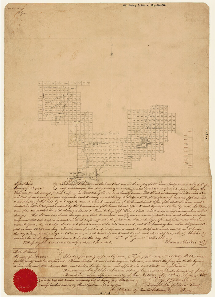
[Surveys made in Peters Colony by Thomas Leckie]
Print $20.00
- Digital $50.00
[Surveys made in Peters Colony by Thomas Leckie]
1858
Size: 22.9 x 16.6 inches
1983
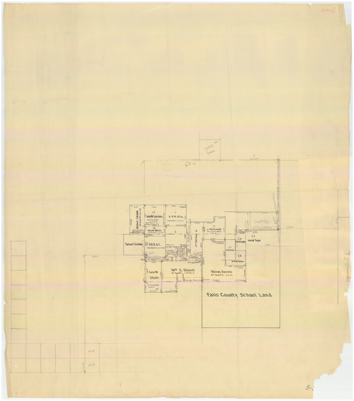
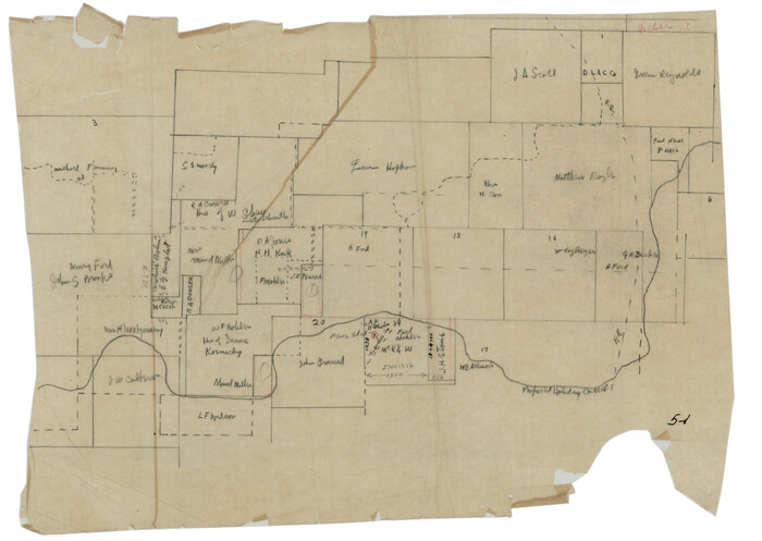
[Surveys in the vicinity of Falls County School Land]
Print $20.00
- Digital $50.00
[Surveys in the vicinity of Falls County School Land]
Size: 32.5 x 37.1 inches
90168
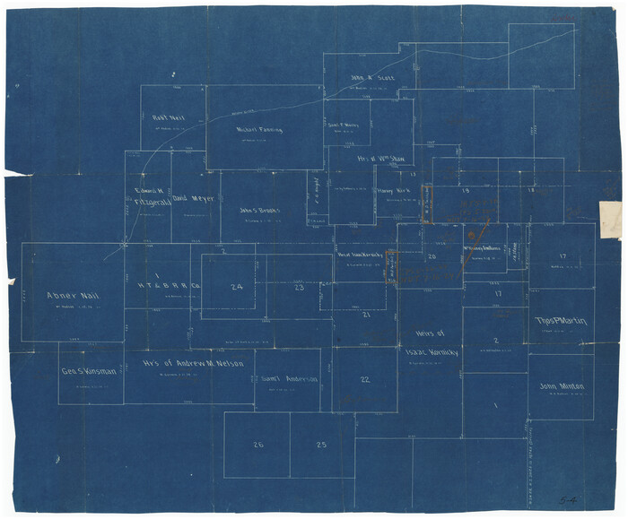
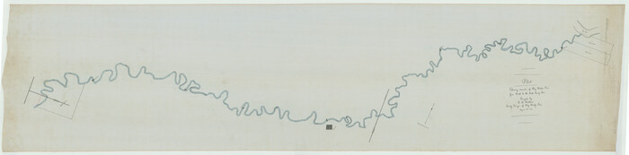
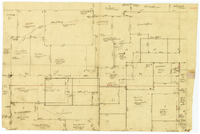
[Sketch showing various surveys south and along Holiday Creek]
Print $20.00
- Digital $50.00
[Sketch showing various surveys south and along Holiday Creek]
Size: 36.1 x 30.1 inches
89979
[Sketch showing various surveys south and along Holiday Creek]
Print $20.00
- Digital $50.00
[Sketch showing various surveys south and along Holiday Creek]
Size: 40.6 x 35.1 inches
90164
[Sketch showing positions of surveys bordering on South boundary line of Archer County and North boundary line of Young County

Print $20.00
- Digital $50.00
[Sketch showing positions of surveys bordering on South boundary line of Archer County and North boundary line of Young County
1894
Size: 14.0 x 36.8 inches
90174
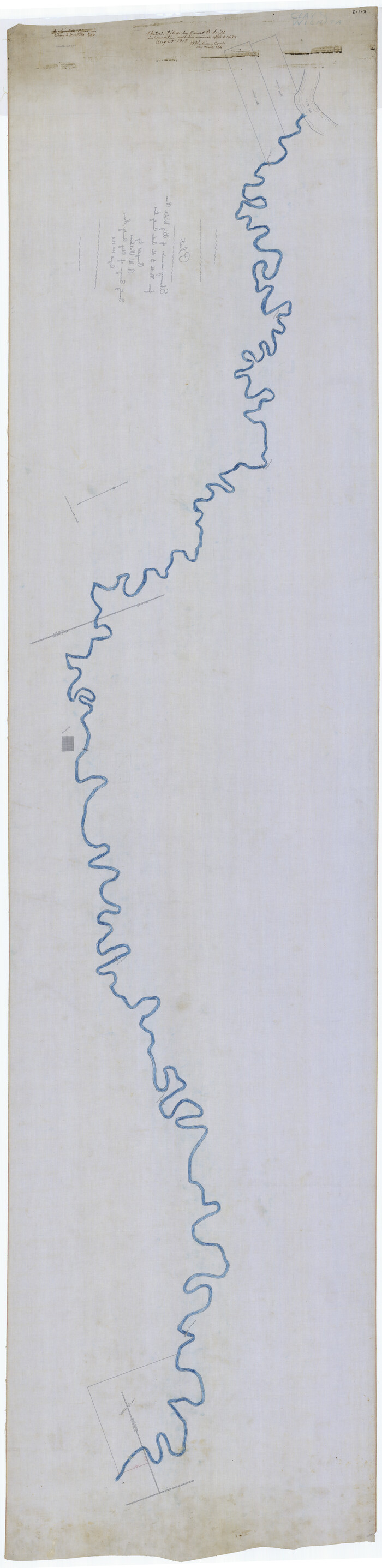
[Sketch for Mineral Application 1487 -Big Wichita River, Ernest R. Smith]
Print $40.00
- Digital $50.00
[Sketch for Mineral Application 1487 -Big Wichita River, Ernest R. Smith]
1918
Size: 32.2 x 130.1 inches
65684
[Sketch for Mineral Application 1487 -Big Wichita River, Ernest R. Smith]
Print $40.00
- Digital $50.00
[Sketch for Mineral Application 1487 -Big Wichita River, Ernest R. Smith]
1918
Size: 129.3 x 31.5 inches
65685
[Red River & Southwestern Ry. Co. from Henrietta to Archer City]
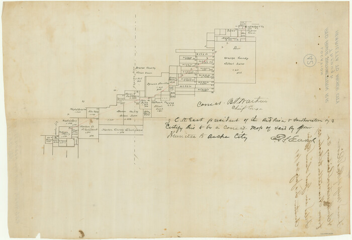
Print $20.00
- Digital $50.00
[Red River & Southwestern Ry. Co. from Henrietta to Archer City]
Size: 14.3 x 21.1 inches
64147
[Pencil sketch showing various surveys south and along Holiday Creek]
Print $20.00
- Digital $50.00
[Pencil sketch showing various surveys south and along Holiday Creek]
Size: 28.3 x 18.8 inches
89978
[Pencil sketch of C. B., H. L. and Jno. Robertson and surrounding surveys]
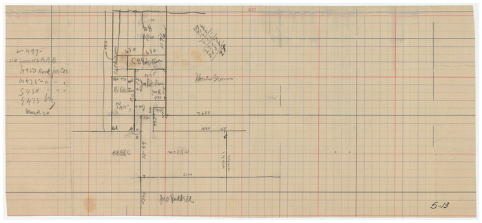
Print $20.00
- Digital $50.00
[Pencil sketch of C. B., H. L. and Jno. Robertson and surrounding surveys]
Size: 21.1 x 9.8 inches
89981
[Pencil sketch around the Fred Mohler survey 19]
Print $3.00
- Digital $50.00
[Pencil sketch around the Fred Mohler survey 19]
Size: 14.1 x 10.4 inches
92994
[Jose Ostane survey]
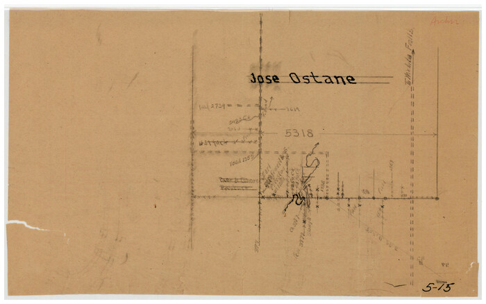
Print $3.00
- Digital $50.00
[Jose Ostane survey]
Size: 14.6 x 9.3 inches
89983
Young Land District

Print $20.00
- Digital $50.00
Young Land District
1857
Size: 21.7 x 29.7 inches
1974
Working Sketch in Archer, Clay & Wichita Co's.

Print $40.00
- Digital $50.00
Working Sketch in Archer, Clay & Wichita Co's.
Size: 68.5 x 43.5 inches
89719
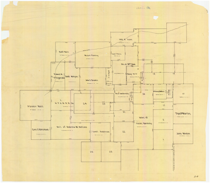
Working Sketch in Archer County

Print $20.00
- Digital $50.00
Working Sketch in Archer County
1924
Size: 30.7 x 42.4 inches
89980
Working Sketch in Archer County

Print $20.00
- Digital $50.00
Working Sketch in Archer County
1921
Size: 15.9 x 19.8 inches
90169
Working Sketch in Archer County

Print $20.00
- Digital $50.00
Working Sketch in Archer County
1924
Size: 30.3 x 42.2 inches
90171
Working Sketch in Archer County

Print $20.00
- Digital $50.00
Working Sketch in Archer County
1924
Size: 30.8 x 42.3 inches
90175
Working Sketch Archer County

Print $20.00
- Digital $50.00
Working Sketch Archer County
1924
Size: 26.6 x 20.5 inches
90257
Wichita County, Texas

Print $20.00
- Digital $50.00
Wichita County, Texas
1890
Size: 26.9 x 32.1 inches
679
Wichita County Sketch File 17

Print $20.00
- Digital $50.00
Wichita County Sketch File 17
1889
Size: 29.7 x 22.4 inches
12680
Water-Shed of the Brazos River

Print $40.00
- Digital $50.00
Water-Shed of the Brazos River
1925
Size: 35.0 x 88.0 inches
65263
Trinity River, Watershed

Print $20.00
- Digital $50.00
Trinity River, Watershed
1925
Size: 46.9 x 40.5 inches
65255
The American Tribune New Colony Company's Lands in Archer County, Texas

Print $20.00
- Digital $50.00
The American Tribune New Colony Company's Lands in Archer County, Texas
Size: 42.9 x 37.5 inches
89742
Right of Way and Track Map, The Wichita Falls & Southern Railway

Print $40.00
- Digital $50.00
Right of Way and Track Map, The Wichita Falls & Southern Railway
1942
Size: 25.5 x 92.5 inches
64513
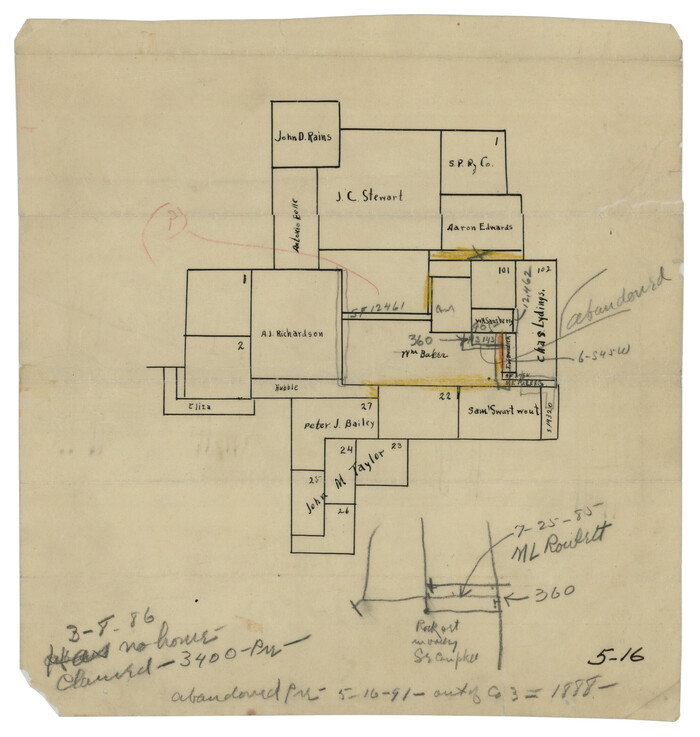
Plat of S. F. No. 12462, S. F. No. 12461, and Adjacent Sur.

Print $20.00
- Digital $50.00
Plat of S. F. No. 12462, S. F. No. 12461, and Adjacent Sur.
1922
Size: 21.2 x 20.1 inches
90172
Map of the Surveyed Part of Young District

Print $40.00
- Digital $50.00
Map of the Surveyed Part of Young District
1860
Size: 56.2 x 54.7 inches
1986
Map of the Surveyed Part of Young District

Print $40.00
- Digital $50.00
Map of the Surveyed Part of Young District
1860
Size: 56.3 x 32.6 inches
87373
Map of the Surveyed Part of Young District

Print $40.00
- Digital $50.00
Map of the Surveyed Part of Young District
1860
Size: 56.3 x 27.3 inches
87374
[Wm. Baker and Chas. Lydings surveys and vicinity]
Print $2.00
- Digital $50.00
[Wm. Baker and Chas. Lydings surveys and vicinity]
-
Size
6.6 x 7.0 inches
-
Map/Doc
92988
[Surveys made in Peters Colony by Thomas Leckie]
Print $20.00
- Digital $50.00
[Surveys made in Peters Colony by Thomas Leckie]
1858
-
Size
22.9 x 16.6 inches
-
Map/Doc
1983
-
Creation Date
1858
[Surveys in the vicinity of Falls County School Land]
Print $20.00
- Digital $50.00
[Surveys in the vicinity of Falls County School Land]
-
Size
32.5 x 37.1 inches
-
Map/Doc
90168
[Sketch showing various surveys south and along Holiday Creek]
Print $20.00
- Digital $50.00
[Sketch showing various surveys south and along Holiday Creek]
-
Size
36.1 x 30.1 inches
-
Map/Doc
89979
[Sketch showing various surveys south and along Holiday Creek]
Print $20.00
- Digital $50.00
[Sketch showing various surveys south and along Holiday Creek]
-
Size
40.6 x 35.1 inches
-
Map/Doc
90164
[Sketch showing positions of surveys bordering on South boundary line of Archer County and North boundary line of Young County
Print $20.00
- Digital $50.00
[Sketch showing positions of surveys bordering on South boundary line of Archer County and North boundary line of Young County
1894
-
Size
14.0 x 36.8 inches
-
Map/Doc
90174
-
Creation Date
1894
[Sketch for Mineral Application 1487 -Big Wichita River, Ernest R. Smith]
Print $40.00
- Digital $50.00
[Sketch for Mineral Application 1487 -Big Wichita River, Ernest R. Smith]
1918
-
Size
32.2 x 130.1 inches
-
Map/Doc
65684
-
Creation Date
1918
[Sketch for Mineral Application 1487 -Big Wichita River, Ernest R. Smith]
Print $40.00
- Digital $50.00
[Sketch for Mineral Application 1487 -Big Wichita River, Ernest R. Smith]
1918
-
Size
129.3 x 31.5 inches
-
Map/Doc
65685
-
Creation Date
1918
[Red River & Southwestern Ry. Co. from Henrietta to Archer City]
Print $20.00
- Digital $50.00
[Red River & Southwestern Ry. Co. from Henrietta to Archer City]
-
Size
14.3 x 21.1 inches
-
Map/Doc
64147
[Pencil sketch showing various surveys south and along Holiday Creek]
Print $20.00
- Digital $50.00
[Pencil sketch showing various surveys south and along Holiday Creek]
-
Size
28.3 x 18.8 inches
-
Map/Doc
89978
[Pencil sketch of C. B., H. L. and Jno. Robertson and surrounding surveys]
Print $20.00
- Digital $50.00
[Pencil sketch of C. B., H. L. and Jno. Robertson and surrounding surveys]
-
Size
21.1 x 9.8 inches
-
Map/Doc
89981
[Pencil sketch around the Fred Mohler survey 19]
Print $3.00
- Digital $50.00
[Pencil sketch around the Fred Mohler survey 19]
-
Size
14.1 x 10.4 inches
-
Map/Doc
92994
[Jose Ostane survey]
Print $3.00
- Digital $50.00
[Jose Ostane survey]
-
Size
14.6 x 9.3 inches
-
Map/Doc
89983
Young Land District
Print $20.00
- Digital $50.00
Young Land District
1857
-
Size
21.7 x 29.7 inches
-
Map/Doc
1974
-
Creation Date
1857
Working Sketch in Archer, Clay & Wichita Co's.
Print $40.00
- Digital $50.00
Working Sketch in Archer, Clay & Wichita Co's.
-
Size
68.5 x 43.5 inches
-
Map/Doc
89719
Working Sketch in Archer County
Print $20.00
- Digital $50.00
Working Sketch in Archer County
1924
-
Size
30.7 x 42.4 inches
-
Map/Doc
89980
-
Creation Date
1924
Working Sketch in Archer County
Print $20.00
- Digital $50.00
Working Sketch in Archer County
1921
-
Size
15.9 x 19.8 inches
-
Map/Doc
90169
-
Creation Date
1921
Working Sketch in Archer County
Print $20.00
- Digital $50.00
Working Sketch in Archer County
1924
-
Size
30.3 x 42.2 inches
-
Map/Doc
90171
-
Creation Date
1924
Working Sketch in Archer County
Print $20.00
- Digital $50.00
Working Sketch in Archer County
1924
-
Size
30.8 x 42.3 inches
-
Map/Doc
90175
-
Creation Date
1924
Working Sketch Archer County
Print $20.00
- Digital $50.00
Working Sketch Archer County
1924
-
Size
26.6 x 20.5 inches
-
Map/Doc
90257
-
Creation Date
1924
Wichita County, Texas
Print $20.00
- Digital $50.00
Wichita County, Texas
1890
-
Size
26.9 x 32.1 inches
-
Map/Doc
679
-
Creation Date
1890
Wichita County Sketch File 17
Print $20.00
- Digital $50.00
Wichita County Sketch File 17
1889
-
Size
29.7 x 22.4 inches
-
Map/Doc
12680
-
Creation Date
1889
Water-Shed of the Brazos River
Print $40.00
- Digital $50.00
Water-Shed of the Brazos River
1925
-
Size
35.0 x 88.0 inches
-
Map/Doc
65263
-
Creation Date
1925
Trinity River, Watershed
Print $20.00
- Digital $50.00
Trinity River, Watershed
1925
-
Size
46.9 x 40.5 inches
-
Map/Doc
65255
-
Creation Date
1925
The American Tribune New Colony Company's Lands in Archer County, Texas
Print $20.00
- Digital $50.00
The American Tribune New Colony Company's Lands in Archer County, Texas
-
Size
42.9 x 37.5 inches
-
Map/Doc
89742
Right of Way and Track Map, The Wichita Falls & Southern Railway
Print $40.00
- Digital $50.00
Right of Way and Track Map, The Wichita Falls & Southern Railway
1942
-
Size
25.5 x 92.5 inches
-
Map/Doc
64513
-
Creation Date
1942
Plat of S. F. No. 12462, S. F. No. 12461, and Adjacent Sur.
Print $20.00
- Digital $50.00
Plat of S. F. No. 12462, S. F. No. 12461, and Adjacent Sur.
1922
-
Size
21.2 x 20.1 inches
-
Map/Doc
90172
-
Creation Date
1922
Map of the Surveyed Part of Young District
Print $40.00
- Digital $50.00
Map of the Surveyed Part of Young District
1860
-
Size
56.2 x 54.7 inches
-
Map/Doc
1986
-
Creation Date
1860
Map of the Surveyed Part of Young District
Print $40.00
- Digital $50.00
Map of the Surveyed Part of Young District
1860
-
Size
56.3 x 32.6 inches
-
Map/Doc
87373
-
Creation Date
1860
Map of the Surveyed Part of Young District
Print $40.00
- Digital $50.00
Map of the Surveyed Part of Young District
1860
-
Size
56.3 x 27.3 inches
-
Map/Doc
87374
-
Creation Date
1860