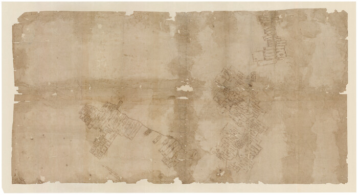
[Surveys in the Bexar District along the Guadalupe River and Cibolo Creek]
Print $20.00
- Digital $50.00
[Surveys in the Bexar District along the Guadalupe River and Cibolo Creek]
1846
Size: 9.6 x 18.3 inches
3169
[Surveys in the Bexar District along the Cibolo Creek]
Print $20.00
- Digital $50.00
[Surveys in the Bexar District along the Cibolo Creek]
1846
Size: 17.0 x 17.8 inches
86
[Surveys in the Bexar District along the Cibolo Creek]
Print $2.00
- Digital $50.00
[Surveys in the Bexar District along the Cibolo Creek]
1847
Size: 13.0 x 7.4 inches
98
[Surveys along the Guadalupe River and Blanco Creek]
Print $20.00
- Digital $50.00
[Surveys along the Guadalupe River and Blanco Creek]
Size: 19.5 x 15.7 inches
45
[Plat of Boundary Line between Comal and Hays Counties]
![65328, [Plat of Boundary Line between Comal and Hays Counties], General Map Collection](https://historictexasmaps.com/wmedia_w700/pdf_converted_jpg/qi_pdf_thumbnail_19768.jpg)
Print $20.00
- Digital $50.00
[Plat of Boundary Line between Comal and Hays Counties]
1947
Size: 11.4 x 17.7 inches
65328
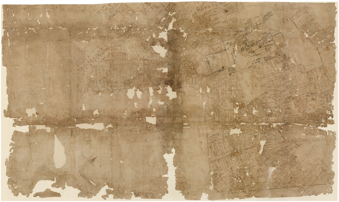
[Bastrop District]
Print $40.00
- Digital $50.00
[Bastrop District]
1838
Size: 67.3 x 44.2 inches
16941
[Bastrop District]
Print $40.00
- Digital $50.00
[Bastrop District]
1895
Size: 36.5 x 52.0 inches
3131
[Bastrop District]
Print $40.00
- Digital $50.00
[Bastrop District]
1895
Size: 37.4 x 51.9 inches
83005
[Bastrop District]
Print $40.00
- Digital $50.00
[Bastrop District]
1895
Size: 71.8 x 52.3 inches
83006
[Bastrop District]
Print $20.00
- Digital $50.00
[Bastrop District]
1838
Size: 25.1 x 46.1 inches
83517
[Bastrop District]
Print $20.00
- Digital $50.00
[Bastrop District]
1838
Size: 19.5 x 44.2 inches
83518
[Bastrop District]
Print $20.00
- Digital $50.00
[Bastrop District]
1838
Size: 26.5 x 44.2 inches
83519
Right of Way and Track Map, the Missouri, Kansas and Texas Ry. of Texas operated by the Missouri, Kansas and Texas Ry. of Texas, San Antonio Division

Print $40.00
- Digital $50.00
Right of Way and Track Map, the Missouri, Kansas and Texas Ry. of Texas operated by the Missouri, Kansas and Texas Ry. of Texas, San Antonio Division
1918
Size: 25.3 x 58.3 inches
64579
Right of Way and Track Map, the Missouri, Kansas and Texas Ry. of Texas operated by the Missouri, Kansas and Texas Ry. of Texas, San Antonio Division

Print $40.00
- Digital $50.00
Right of Way and Track Map, the Missouri, Kansas and Texas Ry. of Texas operated by the Missouri, Kansas and Texas Ry. of Texas, San Antonio Division
1918
Size: 25.4 x 59.2 inches
64580
Right of Way and Track Map, the Missouri, Kansas and Texas Ry. of Texas operated by the Missouri, Kansas and Texas Ry. of Texas, San Antonio Division

Print $40.00
- Digital $50.00
Right of Way and Track Map, the Missouri, Kansas and Texas Ry. of Texas operated by the Missouri, Kansas and Texas Ry. of Texas, San Antonio Division
1918
Size: 25.6 x 58.7 inches
64581
Right of Way and Track Map, the Missouri, Kansas and Texas Ry. of Texas operated by the Missouri, Kansas and Texas Ry. of Texas, San Antonio Division

Print $40.00
- Digital $50.00
Right of Way and Track Map, the Missouri, Kansas and Texas Ry. of Texas operated by the Missouri, Kansas and Texas Ry. of Texas, San Antonio Division
1918
Size: 25.6 x 57.8 inches
64582
Right of Way and Track Map, the Missouri, Kansas and Texas Ry. of Texas operated by the Missouri, Kansas and Texas Ry. of Texas, San Antonio Division

Print $40.00
- Digital $50.00
Right of Way and Track Map, the Missouri, Kansas and Texas Ry. of Texas operated by the Missouri, Kansas and Texas Ry. of Texas, San Antonio Division
1918
Size: 26.0 x 57.8 inches
64583
Right of Way and Track Map, the Missouri, Kansas and Texas Ry. of Texas operated by the Missouri, Kansas and Texas Ry. of Texas, San Antonio Division

Print $40.00
- Digital $50.00
Right of Way and Track Map, the Missouri, Kansas and Texas Ry. of Texas operated by the Missouri, Kansas and Texas Ry. of Texas, San Antonio Division
1918
Size: 25.2 x 58.8 inches
64584
Right of Way and Track Map, the Missouri, Kansas and Texas Ry. of Texas operated by the Missouri, Kansas and Texas Ry. of Texas, San Antonio Division

Print $40.00
- Digital $50.00
Right of Way and Track Map, the Missouri, Kansas and Texas Ry. of Texas operated by the Missouri, Kansas and Texas Ry. of Texas, San Antonio Division
1918
Size: 25.1 x 57.7 inches
64585
Right of Way and Track Map International & Gt Northern Ry. operated by the International & Gt. Northern Ry. Co., San Antonio Division

Print $40.00
- Digital $50.00
Right of Way and Track Map International & Gt Northern Ry. operated by the International & Gt. Northern Ry. Co., San Antonio Division
1917
Size: 25.7 x 63.1 inches
64586
Right of Way and Track Map International & Gt Northern Ry. operated by the International & Gt. Northern Ry. Co., San Antonio Division

Print $40.00
- Digital $50.00
Right of Way and Track Map International & Gt Northern Ry. operated by the International & Gt. Northern Ry. Co., San Antonio Division
1917
Size: 25.6 x 58.1 inches
64587
Right of Way and Track Map International & Gt Northern Ry. operated by the International & Gt. Northern Ry. Co., San Antonio Division

Print $40.00
- Digital $50.00
Right of Way and Track Map International & Gt Northern Ry. operated by the International & Gt. Northern Ry. Co., San Antonio Division
1917
Size: 25.9 x 57.5 inches
64588
Right of Way and Track Map International & Gt Northern Ry. operated by the International & Gt. Northern Ry. Co., San Antonio Division

Print $40.00
- Digital $50.00
Right of Way and Track Map International & Gt Northern Ry. operated by the International & Gt. Northern Ry. Co., San Antonio Division
1917
Size: 25.5 x 57.3 inches
64589
Right of Way and Track Map International & Gt Northern Ry. operated by the International & Gt. Northern Ry. Co., San Antonio Division

Print $40.00
- Digital $50.00
Right of Way and Track Map International & Gt Northern Ry. operated by the International & Gt. Northern Ry. Co., San Antonio Division
1917
Size: 25.4 x 58.1 inches
64787
Right of Way and Track Map International & Gt Northern Ry. operated by the International & Gt. Northern Ry. Co., San Antonio Division

Print $40.00
- Digital $50.00
Right of Way and Track Map International & Gt Northern Ry. operated by the International & Gt. Northern Ry. Co., San Antonio Division
1917
Size: 26.2 x 58.6 inches
64788
Right of Way and Track Map International & Gt Northern Ry. operated by the International & Gt. Northern Ry. Co., San Antonio Division

Print $40.00
- Digital $50.00
Right of Way and Track Map International & Gt Northern Ry. operated by the International & Gt. Northern Ry. Co., San Antonio Division
1917
Size: 25.5 x 57.8 inches
64789
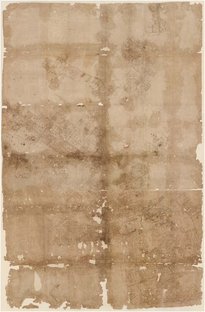
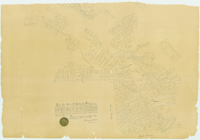
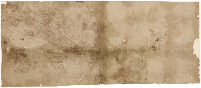
Map representing the surveys made in Bexar County

Print $40.00
- Digital $50.00
Map representing the surveys made in Bexar County
1839
Size: 76.0 x 68.4 inches
1947
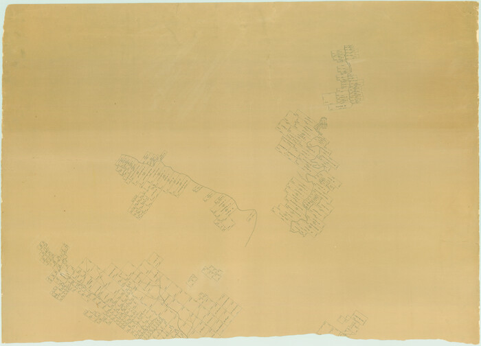
Map representing the surveys made in Bexar County

Print $40.00
- Digital $50.00
Map representing the surveys made in Bexar County
1839
Size: 75.7 x 37.9 inches
93364
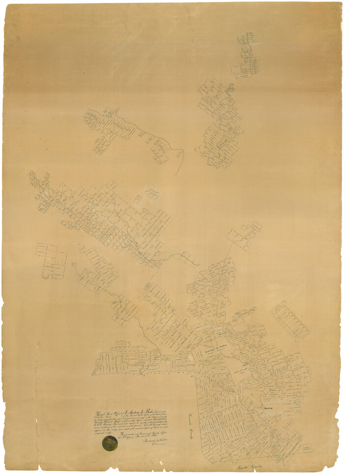
Map representing the surveys made in Bexar County

Print $40.00
- Digital $50.00
Map representing the surveys made in Bexar County
1839
Size: 75.7 x 35.1 inches
93365
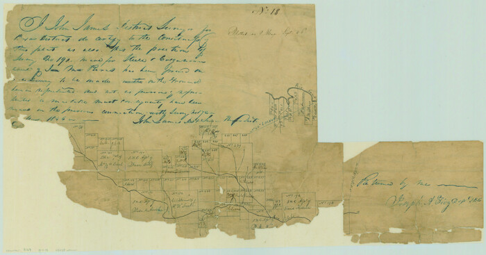
[Surveys in the Bexar District along the Guadalupe River and Cibolo Creek]
Print $20.00
- Digital $50.00
[Surveys in the Bexar District along the Guadalupe River and Cibolo Creek]
1846
-
Size
9.6 x 18.3 inches
-
Map/Doc
3169
-
Creation Date
1846
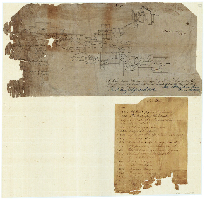
[Surveys in the Bexar District along the Cibolo Creek]
Print $20.00
- Digital $50.00
[Surveys in the Bexar District along the Cibolo Creek]
1846
-
Size
17.0 x 17.8 inches
-
Map/Doc
86
-
Creation Date
1846
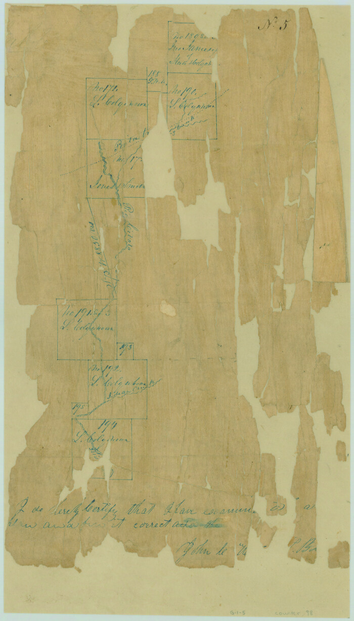
[Surveys in the Bexar District along the Cibolo Creek]
Print $2.00
- Digital $50.00
[Surveys in the Bexar District along the Cibolo Creek]
1847
-
Size
13.0 x 7.4 inches
-
Map/Doc
98
-
Creation Date
1847
[Surveys along the Guadalupe River and Blanco Creek]
Print $20.00
- Digital $50.00
[Surveys along the Guadalupe River and Blanco Creek]
-
Size
19.5 x 15.7 inches
-
Map/Doc
45
[Plat of Boundary Line between Comal and Hays Counties]
Print $20.00
- Digital $50.00
[Plat of Boundary Line between Comal and Hays Counties]
1947
-
Size
11.4 x 17.7 inches
-
Map/Doc
65328
-
Creation Date
1947
[Bastrop District]
Print $40.00
- Digital $50.00
[Bastrop District]
1838
-
Size
67.3 x 44.2 inches
-
Map/Doc
16941
-
Creation Date
1838
[Bastrop District]
Print $40.00
- Digital $50.00
[Bastrop District]
1895
-
Size
36.5 x 52.0 inches
-
Map/Doc
3131
-
Creation Date
1895
[Bastrop District]
Print $40.00
- Digital $50.00
[Bastrop District]
1895
-
Size
37.4 x 51.9 inches
-
Map/Doc
83005
-
Creation Date
1895
[Bastrop District]
Print $40.00
- Digital $50.00
[Bastrop District]
1895
-
Size
71.8 x 52.3 inches
-
Map/Doc
83006
-
Creation Date
1895
[Bastrop District]
Print $20.00
- Digital $50.00
[Bastrop District]
1838
-
Size
25.1 x 46.1 inches
-
Map/Doc
83517
-
Creation Date
1838
[Bastrop District]
Print $20.00
- Digital $50.00
[Bastrop District]
1838
-
Size
19.5 x 44.2 inches
-
Map/Doc
83518
-
Creation Date
1838
[Bastrop District]
Print $20.00
- Digital $50.00
[Bastrop District]
1838
-
Size
26.5 x 44.2 inches
-
Map/Doc
83519
-
Creation Date
1838
Texas Hill Country Trail Region

Texas Hill Country Trail Region
2017
-
Size
18.2 x 24.3 inches
-
Map/Doc
96871
-
Creation Date
2017
Right of Way and Track Map, the Missouri, Kansas and Texas Ry. of Texas operated by the Missouri, Kansas and Texas Ry. of Texas, San Antonio Division
Print $40.00
- Digital $50.00
Right of Way and Track Map, the Missouri, Kansas and Texas Ry. of Texas operated by the Missouri, Kansas and Texas Ry. of Texas, San Antonio Division
1918
-
Size
25.3 x 58.3 inches
-
Map/Doc
64579
-
Creation Date
1918
Right of Way and Track Map, the Missouri, Kansas and Texas Ry. of Texas operated by the Missouri, Kansas and Texas Ry. of Texas, San Antonio Division
Print $40.00
- Digital $50.00
Right of Way and Track Map, the Missouri, Kansas and Texas Ry. of Texas operated by the Missouri, Kansas and Texas Ry. of Texas, San Antonio Division
1918
-
Size
25.4 x 59.2 inches
-
Map/Doc
64580
-
Creation Date
1918
Right of Way and Track Map, the Missouri, Kansas and Texas Ry. of Texas operated by the Missouri, Kansas and Texas Ry. of Texas, San Antonio Division
Print $40.00
- Digital $50.00
Right of Way and Track Map, the Missouri, Kansas and Texas Ry. of Texas operated by the Missouri, Kansas and Texas Ry. of Texas, San Antonio Division
1918
-
Size
25.6 x 58.7 inches
-
Map/Doc
64581
-
Creation Date
1918
Right of Way and Track Map, the Missouri, Kansas and Texas Ry. of Texas operated by the Missouri, Kansas and Texas Ry. of Texas, San Antonio Division
Print $40.00
- Digital $50.00
Right of Way and Track Map, the Missouri, Kansas and Texas Ry. of Texas operated by the Missouri, Kansas and Texas Ry. of Texas, San Antonio Division
1918
-
Size
25.6 x 57.8 inches
-
Map/Doc
64582
-
Creation Date
1918
Right of Way and Track Map, the Missouri, Kansas and Texas Ry. of Texas operated by the Missouri, Kansas and Texas Ry. of Texas, San Antonio Division
Print $40.00
- Digital $50.00
Right of Way and Track Map, the Missouri, Kansas and Texas Ry. of Texas operated by the Missouri, Kansas and Texas Ry. of Texas, San Antonio Division
1918
-
Size
26.0 x 57.8 inches
-
Map/Doc
64583
-
Creation Date
1918
Right of Way and Track Map, the Missouri, Kansas and Texas Ry. of Texas operated by the Missouri, Kansas and Texas Ry. of Texas, San Antonio Division
Print $40.00
- Digital $50.00
Right of Way and Track Map, the Missouri, Kansas and Texas Ry. of Texas operated by the Missouri, Kansas and Texas Ry. of Texas, San Antonio Division
1918
-
Size
25.2 x 58.8 inches
-
Map/Doc
64584
-
Creation Date
1918
Right of Way and Track Map, the Missouri, Kansas and Texas Ry. of Texas operated by the Missouri, Kansas and Texas Ry. of Texas, San Antonio Division
Print $40.00
- Digital $50.00
Right of Way and Track Map, the Missouri, Kansas and Texas Ry. of Texas operated by the Missouri, Kansas and Texas Ry. of Texas, San Antonio Division
1918
-
Size
25.1 x 57.7 inches
-
Map/Doc
64585
-
Creation Date
1918
Right of Way and Track Map International & Gt Northern Ry. operated by the International & Gt. Northern Ry. Co., San Antonio Division
Print $40.00
- Digital $50.00
Right of Way and Track Map International & Gt Northern Ry. operated by the International & Gt. Northern Ry. Co., San Antonio Division
1917
-
Size
25.7 x 63.1 inches
-
Map/Doc
64586
-
Creation Date
1917
Right of Way and Track Map International & Gt Northern Ry. operated by the International & Gt. Northern Ry. Co., San Antonio Division
Print $40.00
- Digital $50.00
Right of Way and Track Map International & Gt Northern Ry. operated by the International & Gt. Northern Ry. Co., San Antonio Division
1917
-
Size
25.6 x 58.1 inches
-
Map/Doc
64587
-
Creation Date
1917
Right of Way and Track Map International & Gt Northern Ry. operated by the International & Gt. Northern Ry. Co., San Antonio Division
Print $40.00
- Digital $50.00
Right of Way and Track Map International & Gt Northern Ry. operated by the International & Gt. Northern Ry. Co., San Antonio Division
1917
-
Size
25.9 x 57.5 inches
-
Map/Doc
64588
-
Creation Date
1917
Right of Way and Track Map International & Gt Northern Ry. operated by the International & Gt. Northern Ry. Co., San Antonio Division
Print $40.00
- Digital $50.00
Right of Way and Track Map International & Gt Northern Ry. operated by the International & Gt. Northern Ry. Co., San Antonio Division
1917
-
Size
25.5 x 57.3 inches
-
Map/Doc
64589
-
Creation Date
1917
Right of Way and Track Map International & Gt Northern Ry. operated by the International & Gt. Northern Ry. Co., San Antonio Division
Print $40.00
- Digital $50.00
Right of Way and Track Map International & Gt Northern Ry. operated by the International & Gt. Northern Ry. Co., San Antonio Division
1917
-
Size
25.4 x 58.1 inches
-
Map/Doc
64787
-
Creation Date
1917
Right of Way and Track Map International & Gt Northern Ry. operated by the International & Gt. Northern Ry. Co., San Antonio Division
Print $40.00
- Digital $50.00
Right of Way and Track Map International & Gt Northern Ry. operated by the International & Gt. Northern Ry. Co., San Antonio Division
1917
-
Size
26.2 x 58.6 inches
-
Map/Doc
64788
-
Creation Date
1917
Right of Way and Track Map International & Gt Northern Ry. operated by the International & Gt. Northern Ry. Co., San Antonio Division
Print $40.00
- Digital $50.00
Right of Way and Track Map International & Gt Northern Ry. operated by the International & Gt. Northern Ry. Co., San Antonio Division
1917
-
Size
25.5 x 57.8 inches
-
Map/Doc
64789
-
Creation Date
1917
Map representing the surveys made in Bexar County
Print $40.00
- Digital $50.00
Map representing the surveys made in Bexar County
1839
-
Size
76.0 x 68.4 inches
-
Map/Doc
1947
-
Creation Date
1839
Map representing the surveys made in Bexar County
Print $40.00
- Digital $50.00
Map representing the surveys made in Bexar County
1839
-
Size
75.7 x 37.9 inches
-
Map/Doc
93364
-
Creation Date
1839
Map representing the surveys made in Bexar County
Print $40.00
- Digital $50.00
Map representing the surveys made in Bexar County
1839
-
Size
75.7 x 35.1 inches
-
Map/Doc
93365
-
Creation Date
1839