Lamar County Working Sketch 12

Print $20.00
- Digital $50.00
Lamar County Working Sketch 12
1994
Size: 40.3 x 34.4 inches
70273
Delta County Working Sketch 3

Print $20.00
- Digital $50.00
Delta County Working Sketch 3
1963
Size: 24.9 x 24.4 inches
68640
Delta County Working Sketch 2

Print $20.00
- Digital $50.00
Delta County Working Sketch 2
1963
Size: 26.6 x 25.2 inches
68639
General Highway Map, Delta County, Hopkins County, Texas

Print $20.00
General Highway Map, Delta County, Hopkins County, Texas
1961
Size: 24.6 x 18.2 inches
79439
General Highway Map, Detail of Cities and Towns in Delta County, Hopkins County [Cooper and vicinity]
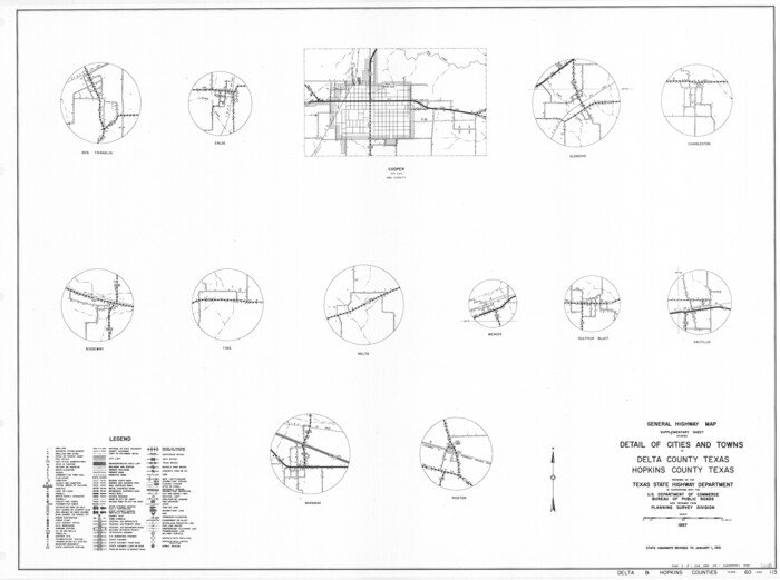
Print $20.00
General Highway Map, Detail of Cities and Towns in Delta County, Hopkins County [Cooper and vicinity]
1961
Size: 18.2 x 24.4 inches
79440
Delta County Working Sketch Graphic Index

Print $20.00
- Digital $50.00
Delta County Working Sketch Graphic Index
1942
Size: 25.3 x 39.2 inches
76520
Delta County Working Sketch 1

Print $20.00
- Digital $50.00
Delta County Working Sketch 1
1942
Size: 24.7 x 28.8 inches
68638
General Highway Map, Delta County, Hopkins County, Texas

Print $20.00
General Highway Map, Delta County, Hopkins County, Texas
1940
Size: 25.2 x 18.5 inches
79073
Sulphur River, Ringo Crossing Sheet

Print $20.00
- Digital $50.00
Sulphur River, Ringo Crossing Sheet
1933
Size: 30.5 x 35.9 inches
65162
North and South Sulphur Rivers, Sulphur Bluff Sheet

Print $20.00
- Digital $50.00
North and South Sulphur Rivers, Sulphur Bluff Sheet
1933
Size: 37.6 x 37.2 inches
65163
Sulphur River, Ringo Crossing Sheet

Print $20.00
- Digital $50.00
Sulphur River, Ringo Crossing Sheet
1933
Size: 18.5 x 20.4 inches
78334
North Sulphur River, Ben Franklin Sheet

Print $40.00
- Digital $50.00
North Sulphur River, Ben Franklin Sheet
1928
Size: 24.6 x 57.4 inches
65172
North Sulphur River, Ben Franklin Sheet

Print $20.00
- Digital $50.00
North Sulphur River, Ben Franklin Sheet
1928
Size: 14.2 x 30.0 inches
78324
North Sulphur River, Mt. Joy Sheet

Print $20.00
- Digital $50.00
North Sulphur River, Mt. Joy Sheet
1926
Size: 33.7 x 40.9 inches
65166
North Sulphur River, Mt. Joy Sheet

Print $20.00
- Digital $50.00
North Sulphur River, Mt. Joy Sheet
1926
Size: 18.4 x 21.6 inches
78333
North Sulphur River, Kinsing Sheet

Print $20.00
- Digital $50.00
North Sulphur River, Kinsing Sheet
1925
Size: 30.5 x 40.8 inches
65165
South Sulphur River, Harpers Crossing Sheet

Print $20.00
- Digital $50.00
South Sulphur River, Harpers Crossing Sheet
1925
Size: 42.2 x 29.2 inches
65169
South Sulphur River, Klondike Sheet

Print $6.00
- Digital $50.00
South Sulphur River, Klondike Sheet
1925
Size: 32.2 x 35.5 inches
65170
Middle Sulphur and South Sulphur Rivers, Horton Sheet

Print $20.00
- Digital $50.00
Middle Sulphur and South Sulphur Rivers, Horton Sheet
1925
Size: 42.2 x 40.3 inches
65171
South Sulphur River, Harpers Crossing Sheet

Print $20.00
- Digital $50.00
South Sulphur River, Harpers Crossing Sheet
1925
Size: 23.3 x 18.0 inches
78328
Middle Sulphur and South Sulphur Rivers, Horton Sheet

Print $20.00
- Digital $50.00
Middle Sulphur and South Sulphur Rivers, Horton Sheet
1925
Size: 25.6 x 22.0 inches
78330
North Sulphur River, Kinsing Sheet

Print $20.00
- Digital $50.00
North Sulphur River, Kinsing Sheet
1925
Size: 18.6 x 23.4 inches
78331
South Sulphur River, Klondike Sheet

Print $20.00
- Digital $50.00
South Sulphur River, Klondike Sheet
1925
Size: 18.2 x 19.9 inches
78332
Levee Improvement Districts Widths of Floodways - Sulphur River and Cuthand Creek

Print $20.00
- Digital $50.00
Levee Improvement Districts Widths of Floodways - Sulphur River and Cuthand Creek
1924
Size: 15.4 x 38.6 inches
65155
North Sulphur River, Sims Crossing Sheet

Print $20.00
- Digital $50.00
North Sulphur River, Sims Crossing Sheet
1924
Size: 23.4 x 39.9 inches
65167
South Sulphur River, Charleston Sheet

Print $4.00
- Digital $50.00
South Sulphur River, Charleston Sheet
1924
Size: 29.4 x 29.5 inches
65168
Lamar County Working Sketch 12
Print $20.00
- Digital $50.00
Lamar County Working Sketch 12
1994
-
Size
40.3 x 34.4 inches
-
Map/Doc
70273
-
Creation Date
1994
Delta County Working Sketch 3
Print $20.00
- Digital $50.00
Delta County Working Sketch 3
1963
-
Size
24.9 x 24.4 inches
-
Map/Doc
68640
-
Creation Date
1963
Delta County Working Sketch 2
Print $20.00
- Digital $50.00
Delta County Working Sketch 2
1963
-
Size
26.6 x 25.2 inches
-
Map/Doc
68639
-
Creation Date
1963
General Highway Map, Delta County, Hopkins County, Texas
Print $20.00
General Highway Map, Delta County, Hopkins County, Texas
1961
-
Size
24.6 x 18.2 inches
-
Map/Doc
79439
-
Creation Date
1961
General Highway Map, Detail of Cities and Towns in Delta County, Hopkins County [Cooper and vicinity]
Print $20.00
General Highway Map, Detail of Cities and Towns in Delta County, Hopkins County [Cooper and vicinity]
1961
-
Size
18.2 x 24.4 inches
-
Map/Doc
79440
-
Creation Date
1961
Delta County

Print $20.00
- Digital $50.00
Delta County
1942
-
Size
28.6 x 39.0 inches
-
Map/Doc
73129
-
Creation Date
1942
Delta County

Print $20.00
- Digital $50.00
Delta County
1942
-
Size
24.5 x 38.0 inches
-
Map/Doc
77261
-
Creation Date
1942
Delta County

Print $20.00
- Digital $50.00
Delta County
1942
-
Size
28.4 x 40.1 inches
-
Map/Doc
95478
-
Creation Date
1942
Delta County

Print $20.00
- Digital $50.00
Delta County
1942
-
Size
26.9 x 39.9 inches
-
Map/Doc
66801
-
Creation Date
1942
Delta County Working Sketch Graphic Index
Print $20.00
- Digital $50.00
Delta County Working Sketch Graphic Index
1942
-
Size
25.3 x 39.2 inches
-
Map/Doc
76520
-
Creation Date
1942
Delta County Working Sketch 1
Print $20.00
- Digital $50.00
Delta County Working Sketch 1
1942
-
Size
24.7 x 28.8 inches
-
Map/Doc
68638
-
Creation Date
1942
General Highway Map, Delta County, Hopkins County, Texas
Print $20.00
General Highway Map, Delta County, Hopkins County, Texas
1940
-
Size
25.2 x 18.5 inches
-
Map/Doc
79073
-
Creation Date
1940
Sulphur River, Ringo Crossing Sheet
Print $20.00
- Digital $50.00
Sulphur River, Ringo Crossing Sheet
1933
-
Size
30.5 x 35.9 inches
-
Map/Doc
65162
-
Creation Date
1933
North and South Sulphur Rivers, Sulphur Bluff Sheet
Print $20.00
- Digital $50.00
North and South Sulphur Rivers, Sulphur Bluff Sheet
1933
-
Size
37.6 x 37.2 inches
-
Map/Doc
65163
-
Creation Date
1933
Sulphur River, Ringo Crossing Sheet
Print $20.00
- Digital $50.00
Sulphur River, Ringo Crossing Sheet
1933
-
Size
18.5 x 20.4 inches
-
Map/Doc
78334
-
Creation Date
1933
North Sulphur River, Ben Franklin Sheet
Print $40.00
- Digital $50.00
North Sulphur River, Ben Franklin Sheet
1928
-
Size
24.6 x 57.4 inches
-
Map/Doc
65172
-
Creation Date
1928
North Sulphur River, Ben Franklin Sheet
Print $20.00
- Digital $50.00
North Sulphur River, Ben Franklin Sheet
1928
-
Size
14.2 x 30.0 inches
-
Map/Doc
78324
-
Creation Date
1928
North Sulphur River, Mt. Joy Sheet
Print $20.00
- Digital $50.00
North Sulphur River, Mt. Joy Sheet
1926
-
Size
33.7 x 40.9 inches
-
Map/Doc
65166
-
Creation Date
1926
North Sulphur River, Mt. Joy Sheet
Print $20.00
- Digital $50.00
North Sulphur River, Mt. Joy Sheet
1926
-
Size
18.4 x 21.6 inches
-
Map/Doc
78333
-
Creation Date
1926
North Sulphur River, Kinsing Sheet
Print $20.00
- Digital $50.00
North Sulphur River, Kinsing Sheet
1925
-
Size
30.5 x 40.8 inches
-
Map/Doc
65165
-
Creation Date
1925
South Sulphur River, Harpers Crossing Sheet
Print $20.00
- Digital $50.00
South Sulphur River, Harpers Crossing Sheet
1925
-
Size
42.2 x 29.2 inches
-
Map/Doc
65169
-
Creation Date
1925
South Sulphur River, Klondike Sheet
Print $6.00
- Digital $50.00
South Sulphur River, Klondike Sheet
1925
-
Size
32.2 x 35.5 inches
-
Map/Doc
65170
-
Creation Date
1925
Middle Sulphur and South Sulphur Rivers, Horton Sheet
Print $20.00
- Digital $50.00
Middle Sulphur and South Sulphur Rivers, Horton Sheet
1925
-
Size
42.2 x 40.3 inches
-
Map/Doc
65171
-
Creation Date
1925
South Sulphur River, Harpers Crossing Sheet
Print $20.00
- Digital $50.00
South Sulphur River, Harpers Crossing Sheet
1925
-
Size
23.3 x 18.0 inches
-
Map/Doc
78328
-
Creation Date
1925
Middle Sulphur and South Sulphur Rivers, Horton Sheet
Print $20.00
- Digital $50.00
Middle Sulphur and South Sulphur Rivers, Horton Sheet
1925
-
Size
25.6 x 22.0 inches
-
Map/Doc
78330
-
Creation Date
1925
North Sulphur River, Kinsing Sheet
Print $20.00
- Digital $50.00
North Sulphur River, Kinsing Sheet
1925
-
Size
18.6 x 23.4 inches
-
Map/Doc
78331
-
Creation Date
1925
South Sulphur River, Klondike Sheet
Print $20.00
- Digital $50.00
South Sulphur River, Klondike Sheet
1925
-
Size
18.2 x 19.9 inches
-
Map/Doc
78332
-
Creation Date
1925
Levee Improvement Districts Widths of Floodways - Sulphur River and Cuthand Creek
Print $20.00
- Digital $50.00
Levee Improvement Districts Widths of Floodways - Sulphur River and Cuthand Creek
1924
-
Size
15.4 x 38.6 inches
-
Map/Doc
65155
-
Creation Date
1924
North Sulphur River, Sims Crossing Sheet
Print $20.00
- Digital $50.00
North Sulphur River, Sims Crossing Sheet
1924
-
Size
23.4 x 39.9 inches
-
Map/Doc
65167
-
Creation Date
1924
South Sulphur River, Charleston Sheet
Print $4.00
- Digital $50.00
South Sulphur River, Charleston Sheet
1924
-
Size
29.4 x 29.5 inches
-
Map/Doc
65168
-
Creation Date
1924