Gillespie County Sketch File 4a

Print $40.00
- Digital $50.00
Gillespie County Sketch File 4a
Size: 15.8 x 12.8 inches
24137
Gillespie County Sketch File 6

Print $4.00
- Digital $50.00
Gillespie County Sketch File 6
Size: 6.4 x 11.0 inches
24139
Gillespie County Sketch File 7a

Print $4.00
- Digital $50.00
Gillespie County Sketch File 7a
Size: 3.5 x 8.1 inches
24143
Kimble County Sketch File 10

Print $23.00
- Digital $50.00
Kimble County Sketch File 10
Size: 18.5 x 15.6 inches
28931
Mason County Sketch File 7

Print $4.00
- Digital $50.00
Mason County Sketch File 7
Size: 7.9 x 8.8 inches
30689
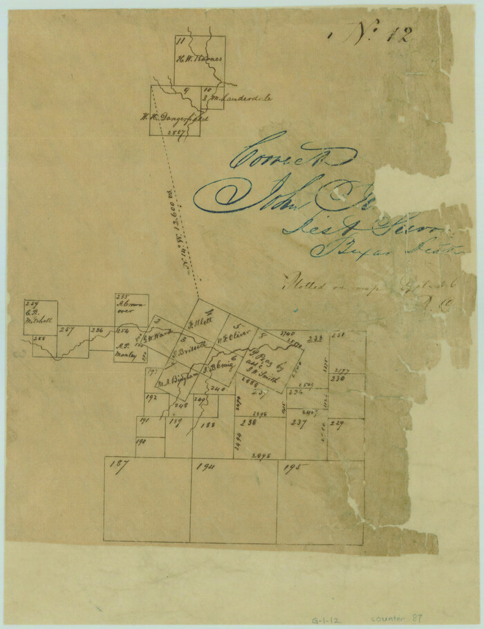
Mason County Sketch File 12

Print $22.00
- Digital $50.00
Mason County Sketch File 12
Size: 15.8 x 12.9 inches
30699
Map of Martinsburg Property, Gillespie Co., Tex.

Print $20.00
- Digital $50.00
Map of Martinsburg Property, Gillespie Co., Tex.
Size: 15.7 x 13.6 inches
446
Gillespie County Boundary File 1

Print $30.00
- Digital $50.00
Gillespie County Boundary File 1
Size: 8.5 x 3.8 inches
53709
Gillespie County Boundary File 2

Print $42.00
- Digital $50.00
Gillespie County Boundary File 2
Size: 6.7 x 4.0 inches
53724
Gillespie County Boundary File 3

Print $34.00
- Digital $50.00
Gillespie County Boundary File 3
Size: 14.3 x 8.8 inches
53736
Gillespie County Boundary File 3a

Print $20.00
- Digital $50.00
Gillespie County Boundary File 3a
Size: 24.6 x 37.6 inches
53753
Gillespie County Boundary File 4

Print $56.00
- Digital $50.00
Gillespie County Boundary File 4
Size: 13.6 x 9.0 inches
53754
Gillespie County Boundary File 5

Print $10.00
- Digital $50.00
Gillespie County Boundary File 5
Size: 14.2 x 9.0 inches
53764
Gillespie County Boundary File 5a

Print $2.00
- Digital $50.00
Gillespie County Boundary File 5a
Size: 8.3 x 7.9 inches
53769
Gillespie County Boundary File 6

Print $2.00
- Digital $50.00
Gillespie County Boundary File 6
Size: 11.3 x 8.9 inches
53770
Gillespie County Boundary File 7

Print $18.00
- Digital $50.00
Gillespie County Boundary File 7
Size: 8.6 x 4.0 inches
53771
Gillespie County Boundary File 7a

Print $40.00
- Digital $50.00
Gillespie County Boundary File 7a
Size: 8.7 x 51.2 inches
53780
Gillespie County Rolled Sketch 3

Print $20.00
- Digital $50.00
Gillespie County Rolled Sketch 3
Size: 19.0 x 28.1 inches
6010
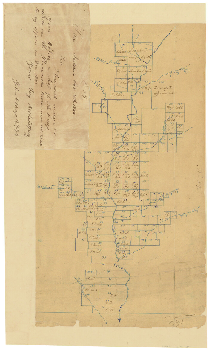
[Surveys in the Bexar District along the Pedernales River]
Print $20.00
- Digital $50.00
[Surveys in the Bexar District along the Pedernales River]
1845
Size: 18.7 x 11.0 inches
177
Gillespie County Rolled Sketch O

Print $20.00
- Digital $50.00
Gillespie County Rolled Sketch O
1846
Size: 42.6 x 20.0 inches
6007
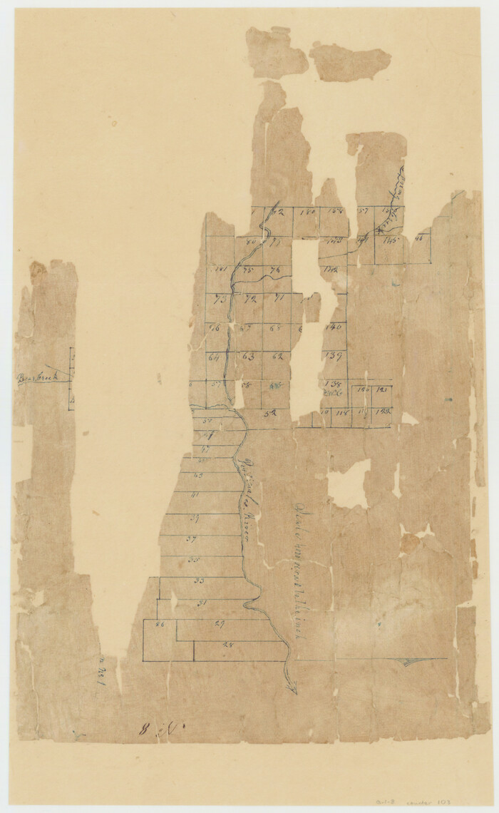
[Surveys near Crabapple Creek in the Bexar District]
Print $2.00
- Digital $50.00
[Surveys near Crabapple Creek in the Bexar District]
1846
Size: 9.1 x 7.0 inches
87
[Sketch of surveys in the Bexar District along the Pedernales River]
Print $2.00
- Digital $50.00
[Sketch of surveys in the Bexar District along the Pedernales River]
1847
Size: 13.6 x 8.3 inches
103
Gillespie County Sketch File 15

Print $20.00
- Digital $50.00
Gillespie County Sketch File 15
1847
Size: 17.7 x 19.3 inches
11556
Gillespie County Sketch File 3

Print $4.00
- Digital $50.00
Gillespie County Sketch File 3
1847
Size: 11.2 x 8.0 inches
24129
Gillespie County Sketch File 1

Print $7.00
- Digital $50.00
Gillespie County Sketch File 1
1847
Size: 10.2 x 8.3 inches
24124
Gillespie County Sketch File 2

Print $40.00
- Digital $50.00
Gillespie County Sketch File 2
1847
Size: 12.8 x 15.5 inches
24127
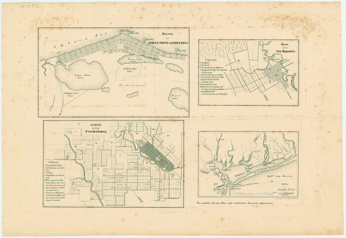
Karte von Indian Point od Indianola / Karte der Stadt Neu Braunfels / Karte der Stadt Friedrichsburg / Hafen von Indian Point oder Indianola

Print $20.00
- Digital $50.00
Karte von Indian Point od Indianola / Karte der Stadt Neu Braunfels / Karte der Stadt Friedrichsburg / Hafen von Indian Point oder Indianola
1850
Size: 13.6 x 19.4 inches
2182
Karte von Indian Point od Indianola / Karte der Stadt Neu Braunfels / Karte der Stadt Friedrichsburg / Hafen von Indian Point oder Indianola (Carlshafen) [Four map insets]
Print $20.00
Karte von Indian Point od Indianola / Karte der Stadt Neu Braunfels / Karte der Stadt Friedrichsburg / Hafen von Indian Point oder Indianola (Carlshafen) [Four map insets]
1850
Size: 13.3 x 19.4 inches
79297
Map of Gillespie County

Print $20.00
- Digital $50.00
Map of Gillespie County
1857
Size: 35.1 x 26.2 inches
3582
Gillespie County Sketch File 4a
Print $40.00
- Digital $50.00
Gillespie County Sketch File 4a
-
Size
15.8 x 12.8 inches
-
Map/Doc
24137
Gillespie County Sketch File 6
Print $4.00
- Digital $50.00
Gillespie County Sketch File 6
-
Size
6.4 x 11.0 inches
-
Map/Doc
24139
Gillespie County Sketch File 7a
Print $4.00
- Digital $50.00
Gillespie County Sketch File 7a
-
Size
3.5 x 8.1 inches
-
Map/Doc
24143
Kimble County Sketch File 10
Print $23.00
- Digital $50.00
Kimble County Sketch File 10
-
Size
18.5 x 15.6 inches
-
Map/Doc
28931
Mason County Sketch File 7
Print $4.00
- Digital $50.00
Mason County Sketch File 7
-
Size
7.9 x 8.8 inches
-
Map/Doc
30689
Mason County Sketch File 12
Print $22.00
- Digital $50.00
Mason County Sketch File 12
-
Size
15.8 x 12.9 inches
-
Map/Doc
30699
Map of Martinsburg Property, Gillespie Co., Tex.
Print $20.00
- Digital $50.00
Map of Martinsburg Property, Gillespie Co., Tex.
-
Size
15.7 x 13.6 inches
-
Map/Doc
446
Gillespie County Boundary File 1
Print $30.00
- Digital $50.00
Gillespie County Boundary File 1
-
Size
8.5 x 3.8 inches
-
Map/Doc
53709
Gillespie County Boundary File 2
Print $42.00
- Digital $50.00
Gillespie County Boundary File 2
-
Size
6.7 x 4.0 inches
-
Map/Doc
53724
Gillespie County Boundary File 3
Print $34.00
- Digital $50.00
Gillespie County Boundary File 3
-
Size
14.3 x 8.8 inches
-
Map/Doc
53736
Gillespie County Boundary File 3a
Print $20.00
- Digital $50.00
Gillespie County Boundary File 3a
-
Size
24.6 x 37.6 inches
-
Map/Doc
53753
Gillespie County Boundary File 4
Print $56.00
- Digital $50.00
Gillespie County Boundary File 4
-
Size
13.6 x 9.0 inches
-
Map/Doc
53754
Gillespie County Boundary File 5
Print $10.00
- Digital $50.00
Gillespie County Boundary File 5
-
Size
14.2 x 9.0 inches
-
Map/Doc
53764
Gillespie County Boundary File 5a
Print $2.00
- Digital $50.00
Gillespie County Boundary File 5a
-
Size
8.3 x 7.9 inches
-
Map/Doc
53769
Gillespie County Boundary File 6
Print $2.00
- Digital $50.00
Gillespie County Boundary File 6
-
Size
11.3 x 8.9 inches
-
Map/Doc
53770
Gillespie County Boundary File 7
Print $18.00
- Digital $50.00
Gillespie County Boundary File 7
-
Size
8.6 x 4.0 inches
-
Map/Doc
53771
Gillespie County Boundary File 7a
Print $40.00
- Digital $50.00
Gillespie County Boundary File 7a
-
Size
8.7 x 51.2 inches
-
Map/Doc
53780
Gillespie County Rolled Sketch 3
Print $20.00
- Digital $50.00
Gillespie County Rolled Sketch 3
-
Size
19.0 x 28.1 inches
-
Map/Doc
6010
Texas Hill Country Trail Region

Texas Hill Country Trail Region
-
Size
18.1 x 24.2 inches
-
Map/Doc
96872
[Surveys in the Bexar District along the Pedernales River]
Print $20.00
- Digital $50.00
[Surveys in the Bexar District along the Pedernales River]
1845
-
Size
18.7 x 11.0 inches
-
Map/Doc
177
-
Creation Date
1845
Gillespie County Rolled Sketch O
Print $20.00
- Digital $50.00
Gillespie County Rolled Sketch O
1846
-
Size
42.6 x 20.0 inches
-
Map/Doc
6007
-
Creation Date
1846
[Surveys near Crabapple Creek in the Bexar District]
Print $2.00
- Digital $50.00
[Surveys near Crabapple Creek in the Bexar District]
1846
-
Size
9.1 x 7.0 inches
-
Map/Doc
87
-
Creation Date
1846
[Sketch of surveys in the Bexar District along the Pedernales River]
Print $2.00
- Digital $50.00
[Sketch of surveys in the Bexar District along the Pedernales River]
1847
-
Size
13.6 x 8.3 inches
-
Map/Doc
103
-
Creation Date
1847
Gillespie County Sketch File 15
Print $20.00
- Digital $50.00
Gillespie County Sketch File 15
1847
-
Size
17.7 x 19.3 inches
-
Map/Doc
11556
-
Creation Date
1847
Gillespie County Sketch File 3
Print $4.00
- Digital $50.00
Gillespie County Sketch File 3
1847
-
Size
11.2 x 8.0 inches
-
Map/Doc
24129
-
Creation Date
1847
Gillespie County Sketch File 1
Print $7.00
- Digital $50.00
Gillespie County Sketch File 1
1847
-
Size
10.2 x 8.3 inches
-
Map/Doc
24124
-
Creation Date
1847
Gillespie County Sketch File 2
Print $40.00
- Digital $50.00
Gillespie County Sketch File 2
1847
-
Size
12.8 x 15.5 inches
-
Map/Doc
24127
-
Creation Date
1847
Karte von Indian Point od Indianola / Karte der Stadt Neu Braunfels / Karte der Stadt Friedrichsburg / Hafen von Indian Point oder Indianola
Print $20.00
- Digital $50.00
Karte von Indian Point od Indianola / Karte der Stadt Neu Braunfels / Karte der Stadt Friedrichsburg / Hafen von Indian Point oder Indianola
1850
-
Size
13.6 x 19.4 inches
-
Map/Doc
2182
-
Creation Date
1850
Karte von Indian Point od Indianola / Karte der Stadt Neu Braunfels / Karte der Stadt Friedrichsburg / Hafen von Indian Point oder Indianola (Carlshafen) [Four map insets]
Print $20.00
Karte von Indian Point od Indianola / Karte der Stadt Neu Braunfels / Karte der Stadt Friedrichsburg / Hafen von Indian Point oder Indianola (Carlshafen) [Four map insets]
1850
-
Size
13.3 x 19.4 inches
-
Map/Doc
79297
-
Creation Date
1850
Map of Gillespie County
Print $20.00
- Digital $50.00
Map of Gillespie County
1857
-
Size
35.1 x 26.2 inches
-
Map/Doc
3582
-
Creation Date
1857