Starr County Sketch File 6

Print $20.00
- Digital $50.00
Starr County Sketch File 6
Size: 43.4 x 36.7 inches
10605
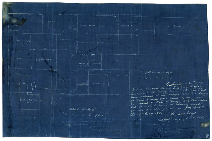
[Map Showing Estivan Martinez "Los Nerios de Tio Ayola" Survey and Surveys North Thereof, Brooks County, Texas]
Print $20.00
- Digital $50.00
[Map Showing Estivan Martinez "Los Nerios de Tio Ayola" Survey and Surveys North Thereof, Brooks County, Texas]
1906
Size: 16.7 x 25.1 inches
10755
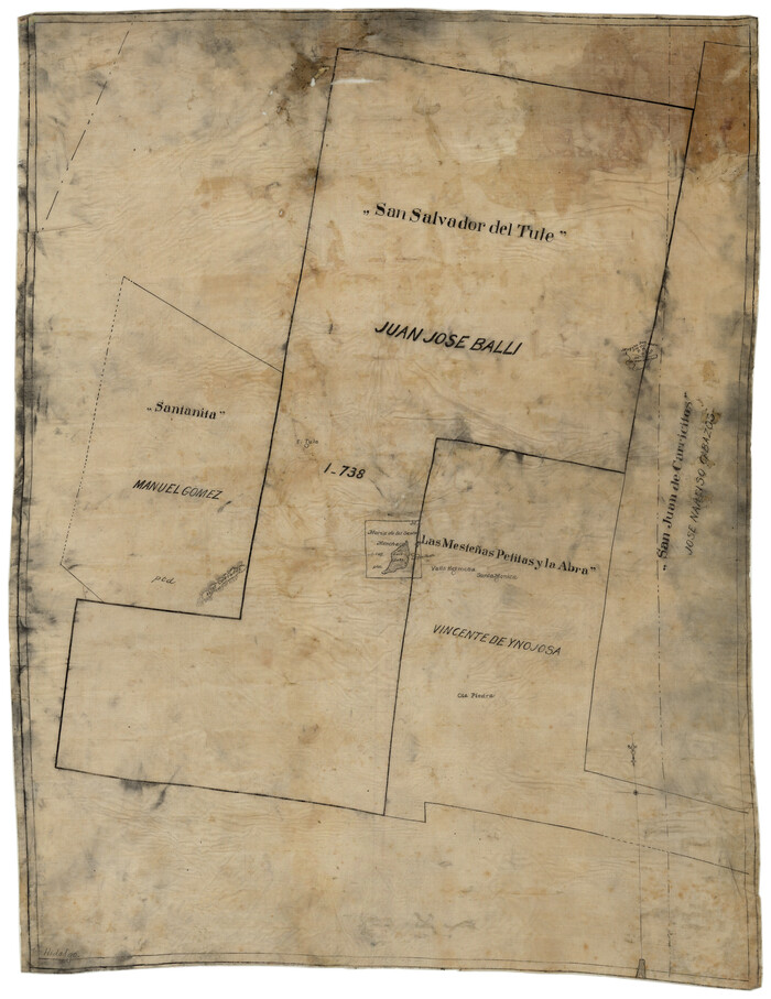
[Sketch of 'San Salvador del Tule', Juan Jose Balli Grant, Hidalgo County, Texas]
Print $20.00
- Digital $50.00
[Sketch of 'San Salvador del Tule', Juan Jose Balli Grant, Hidalgo County, Texas]
Size: 22.0 x 17.5 inches
10756
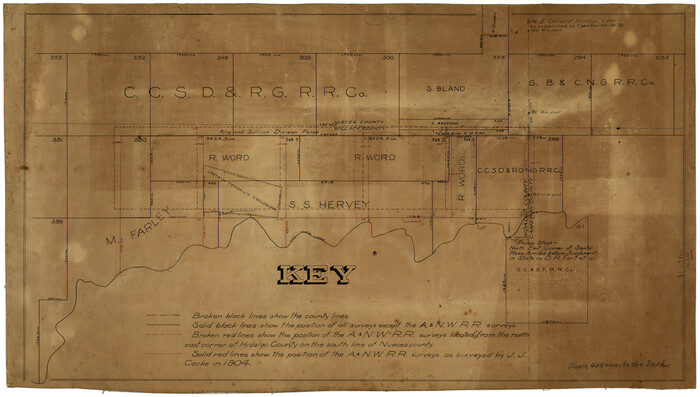
[Surveying Sketch of M. Farley, R. Word, S. S. Hervey, et al in Kleberg County, Texas]
Print $20.00
- Digital $50.00
[Surveying Sketch of M. Farley, R. Word, S. S. Hervey, et al in Kleberg County, Texas]
Size: 23.2 x 40.6 inches
10783
Hidalgo County Sketch File 4

Print $20.00
- Digital $50.00
Hidalgo County Sketch File 4
Size: 21.4 x 25.2 inches
11760
Hidalgo County Sketch File 7

Print $20.00
- Digital $50.00
Hidalgo County Sketch File 7
1882
Size: 20.3 x 28.2 inches
11761
Hidalgo County Sketch File 10

Print $20.00
- Digital $50.00
Hidalgo County Sketch File 10
1911
Size: 16.3 x 34.8 inches
11762
Hidalgo County Sketch File 12

Print $20.00
- Digital $50.00
Hidalgo County Sketch File 12
Size: 16.3 x 25.1 inches
11763
Hidalgo County Sketch File 14

Print $20.00
- Digital $50.00
Hidalgo County Sketch File 14
Size: 29.6 x 24.5 inches
11764
Starr County Sketch File 7

Print $20.00
- Digital $50.00
Starr County Sketch File 7
Size: 25.4 x 20.8 inches
12326
Map of San Patricio District

Print $40.00
- Digital $50.00
Map of San Patricio District
1870
Size: 43.8 x 51.4 inches
1987
Jalisco Banco Number 67, cut from Mexico in 1909

Print $3.00
- Digital $50.00
Jalisco Banco Number 67, cut from Mexico in 1909
1912
Size: 14.2 x 11.2 inches
2064
Rio Grande from San Juan River to the Gulf of Mexico showing Boundary between the United States and Mexico

Print $20.00
- Digital $50.00
Rio Grande from San Juan River to the Gulf of Mexico showing Boundary between the United States and Mexico
1903
Size: 25.6 x 15.8 inches
2065
Plat showing proposed counties to be taken from Zapata, Starr & Hidalgo Counties

Print $20.00
- Digital $50.00
Plat showing proposed counties to be taken from Zapata, Starr & Hidalgo Counties
1911
Size: 24.8 x 27.0 inches
2478
Hidalgo County Sketch File 1

Print $40.00
- Digital $50.00
Hidalgo County Sketch File 1
Size: 20.2 x 12.0 inches
26392
Hidalgo County Sketch File 2

Print $14.00
- Digital $50.00
Hidalgo County Sketch File 2
1877
Size: 10.1 x 8.1 inches
26394
Hidalgo County Sketch File 3

Print $40.00
- Digital $50.00
Hidalgo County Sketch File 3
1878
Size: 14.1 x 13.1 inches
26401
Hidalgo County Sketch File 6

Print $4.00
- Digital $50.00
Hidalgo County Sketch File 6
1891
Size: 10.3 x 8.4 inches
26403
Hidalgo County Sketch File 7a

Print $4.00
- Digital $50.00
Hidalgo County Sketch File 7a
1886
Size: 12.8 x 8.2 inches
26405
Hidalgo County Sketch File 8

Print $4.00
- Digital $50.00
Hidalgo County Sketch File 8
1890
Size: 14.1 x 8.6 inches
26407
Hidalgo County Sketch File 9

Print $40.00
- Digital $50.00
Hidalgo County Sketch File 9
1904
Size: 8.8 x 5.7 inches
26409
Hidalgo County Sketch File 11

Print $40.00
- Digital $50.00
Hidalgo County Sketch File 11
1908
Size: 18.5 x 13.6 inches
26429
Hidalgo County Sketch File 15

Print $12.00
- Digital $50.00
Hidalgo County Sketch File 15
1878
Size: 10.1 x 7.9 inches
26431
Hidalgo County Sketch File 17

Print $6.00
- Digital $50.00
Hidalgo County Sketch File 17
1950
Size: 14.5 x 8.8 inches
26443
Hidalgo County Sketch File 18

Print $4.00
- Digital $50.00
Hidalgo County Sketch File 18
Size: 12.0 x 8.1 inches
26446
Hidalgo County Sketch File 19

Print $42.00
- Digital $50.00
Hidalgo County Sketch File 19
1983
Size: 11.3 x 8.9 inches
26448
Plat showing proposed counties to be taken from Zapata, Starr & Hidalgo Counties

Print $20.00
- Digital $50.00
Plat showing proposed counties to be taken from Zapata, Starr & Hidalgo Counties
1911
Size: 24.8 x 27.8 inches
2660
Kenedy County Sketch File 1

Print $68.00
- Digital $50.00
Kenedy County Sketch File 1
1950
Size: 14.2 x 8.8 inches
28739
Map of Cameron, Hidalgo and half of Starr County of Texas

Print $20.00
- Digital $50.00
Map of Cameron, Hidalgo and half of Starr County of Texas
1900
Size: 42.4 x 30.3 inches
3150
Starr County Sketch File 6
Print $20.00
- Digital $50.00
Starr County Sketch File 6
-
Size
43.4 x 36.7 inches
-
Map/Doc
10605
[Map Showing Estivan Martinez "Los Nerios de Tio Ayola" Survey and Surveys North Thereof, Brooks County, Texas]
Print $20.00
- Digital $50.00
[Map Showing Estivan Martinez "Los Nerios de Tio Ayola" Survey and Surveys North Thereof, Brooks County, Texas]
1906
-
Size
16.7 x 25.1 inches
-
Map/Doc
10755
-
Creation Date
1906
[Sketch of 'San Salvador del Tule', Juan Jose Balli Grant, Hidalgo County, Texas]
Print $20.00
- Digital $50.00
[Sketch of 'San Salvador del Tule', Juan Jose Balli Grant, Hidalgo County, Texas]
-
Size
22.0 x 17.5 inches
-
Map/Doc
10756
[Surveying Sketch of M. Farley, R. Word, S. S. Hervey, et al in Kleberg County, Texas]
Print $20.00
- Digital $50.00
[Surveying Sketch of M. Farley, R. Word, S. S. Hervey, et al in Kleberg County, Texas]
-
Size
23.2 x 40.6 inches
-
Map/Doc
10783
Hidalgo County Sketch File 4
Print $20.00
- Digital $50.00
Hidalgo County Sketch File 4
-
Size
21.4 x 25.2 inches
-
Map/Doc
11760
Hidalgo County Sketch File 7
Print $20.00
- Digital $50.00
Hidalgo County Sketch File 7
1882
-
Size
20.3 x 28.2 inches
-
Map/Doc
11761
-
Creation Date
1882
Hidalgo County Sketch File 10
Print $20.00
- Digital $50.00
Hidalgo County Sketch File 10
1911
-
Size
16.3 x 34.8 inches
-
Map/Doc
11762
-
Creation Date
1911
Hidalgo County Sketch File 12
Print $20.00
- Digital $50.00
Hidalgo County Sketch File 12
-
Size
16.3 x 25.1 inches
-
Map/Doc
11763
Hidalgo County Sketch File 14
Print $20.00
- Digital $50.00
Hidalgo County Sketch File 14
-
Size
29.6 x 24.5 inches
-
Map/Doc
11764
Starr County Sketch File 7
Print $20.00
- Digital $50.00
Starr County Sketch File 7
-
Size
25.4 x 20.8 inches
-
Map/Doc
12326
Hidalgo County

Print $20.00
- Digital $50.00
Hidalgo County
1911
-
Size
42.1 x 28.7 inches
-
Map/Doc
16850
-
Creation Date
1911
Map of San Patricio District
Print $40.00
- Digital $50.00
Map of San Patricio District
1870
-
Size
43.8 x 51.4 inches
-
Map/Doc
1987
-
Creation Date
1870
Jalisco Banco Number 67, cut from Mexico in 1909
Print $3.00
- Digital $50.00
Jalisco Banco Number 67, cut from Mexico in 1909
1912
-
Size
14.2 x 11.2 inches
-
Map/Doc
2064
-
Creation Date
1912
Rio Grande from San Juan River to the Gulf of Mexico showing Boundary between the United States and Mexico
Print $20.00
- Digital $50.00
Rio Grande from San Juan River to the Gulf of Mexico showing Boundary between the United States and Mexico
1903
-
Size
25.6 x 15.8 inches
-
Map/Doc
2065
-
Creation Date
1903
Plat showing proposed counties to be taken from Zapata, Starr & Hidalgo Counties
Print $20.00
- Digital $50.00
Plat showing proposed counties to be taken from Zapata, Starr & Hidalgo Counties
1911
-
Size
24.8 x 27.0 inches
-
Map/Doc
2478
-
Creation Date
1911
Hidalgo County Sketch File 1
Print $40.00
- Digital $50.00
Hidalgo County Sketch File 1
-
Size
20.2 x 12.0 inches
-
Map/Doc
26392
Hidalgo County Sketch File 2
Print $14.00
- Digital $50.00
Hidalgo County Sketch File 2
1877
-
Size
10.1 x 8.1 inches
-
Map/Doc
26394
-
Creation Date
1877
Hidalgo County Sketch File 3
Print $40.00
- Digital $50.00
Hidalgo County Sketch File 3
1878
-
Size
14.1 x 13.1 inches
-
Map/Doc
26401
-
Creation Date
1878
Hidalgo County Sketch File 6
Print $4.00
- Digital $50.00
Hidalgo County Sketch File 6
1891
-
Size
10.3 x 8.4 inches
-
Map/Doc
26403
-
Creation Date
1891
Hidalgo County Sketch File 7a
Print $4.00
- Digital $50.00
Hidalgo County Sketch File 7a
1886
-
Size
12.8 x 8.2 inches
-
Map/Doc
26405
-
Creation Date
1886
Hidalgo County Sketch File 8
Print $4.00
- Digital $50.00
Hidalgo County Sketch File 8
1890
-
Size
14.1 x 8.6 inches
-
Map/Doc
26407
-
Creation Date
1890
Hidalgo County Sketch File 9
Print $40.00
- Digital $50.00
Hidalgo County Sketch File 9
1904
-
Size
8.8 x 5.7 inches
-
Map/Doc
26409
-
Creation Date
1904
Hidalgo County Sketch File 11
Print $40.00
- Digital $50.00
Hidalgo County Sketch File 11
1908
-
Size
18.5 x 13.6 inches
-
Map/Doc
26429
-
Creation Date
1908
Hidalgo County Sketch File 15
Print $12.00
- Digital $50.00
Hidalgo County Sketch File 15
1878
-
Size
10.1 x 7.9 inches
-
Map/Doc
26431
-
Creation Date
1878
Hidalgo County Sketch File 17
Print $6.00
- Digital $50.00
Hidalgo County Sketch File 17
1950
-
Size
14.5 x 8.8 inches
-
Map/Doc
26443
-
Creation Date
1950
Hidalgo County Sketch File 18
Print $4.00
- Digital $50.00
Hidalgo County Sketch File 18
-
Size
12.0 x 8.1 inches
-
Map/Doc
26446
Hidalgo County Sketch File 19
Print $42.00
- Digital $50.00
Hidalgo County Sketch File 19
1983
-
Size
11.3 x 8.9 inches
-
Map/Doc
26448
-
Creation Date
1983
Plat showing proposed counties to be taken from Zapata, Starr & Hidalgo Counties
Print $20.00
- Digital $50.00
Plat showing proposed counties to be taken from Zapata, Starr & Hidalgo Counties
1911
-
Size
24.8 x 27.8 inches
-
Map/Doc
2660
-
Creation Date
1911
Kenedy County Sketch File 1
Print $68.00
- Digital $50.00
Kenedy County Sketch File 1
1950
-
Size
14.2 x 8.8 inches
-
Map/Doc
28739
-
Creation Date
1950
Map of Cameron, Hidalgo and half of Starr County of Texas
Print $20.00
- Digital $50.00
Map of Cameron, Hidalgo and half of Starr County of Texas
1900
-
Size
42.4 x 30.3 inches
-
Map/Doc
3150
-
Creation Date
1900