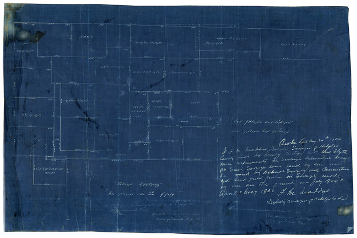
[Working Sketch of a portion of Hidalgo & Starr Co's.]
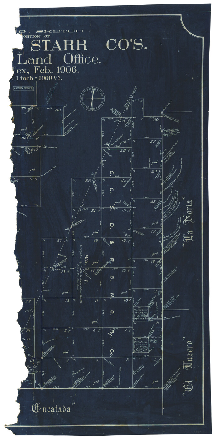
Print $20.00
- Digital $50.00
[Working Sketch of a portion of Hidalgo & Starr Co's.]
1906
Size: 27.8 x 13.8 inches
4447
[Tex Mex & CCSDRG&G Railroad Blocks in Starr and Hidalgo Counties, Texas]
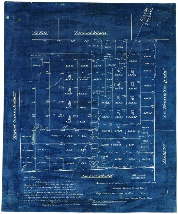
Print $20.00
- Digital $50.00
[Tex Mex & CCSDRG&G Railroad Blocks in Starr and Hidalgo Counties, Texas]
1906
Size: 28.7 x 24.2 inches
4452
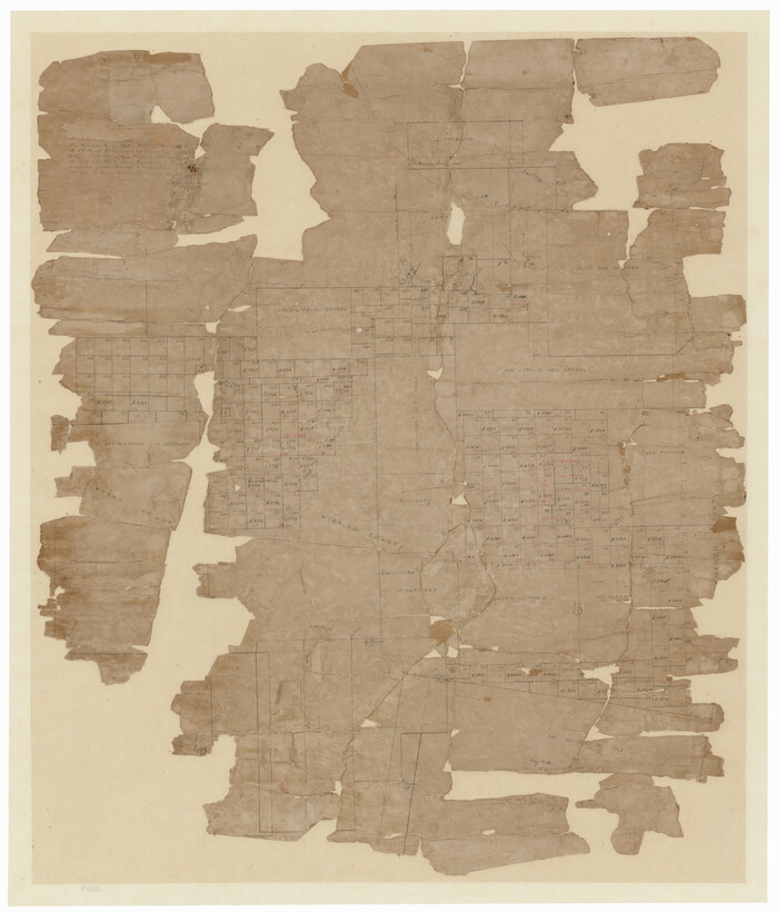
[Surveying Sketch of M. Farley, R. Word, S. S. Hervey, et al in Kleberg County, Texas]
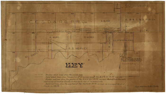
Print $20.00
- Digital $50.00
[Surveying Sketch of M. Farley, R. Word, S. S. Hervey, et al in Kleberg County, Texas]
Size: 23.2 x 40.6 inches
10783
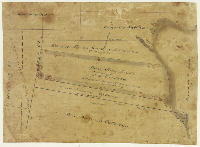
[Sketch of 'San Salvador del Tule', Juan Jose Balli Grant, Hidalgo County, Texas]
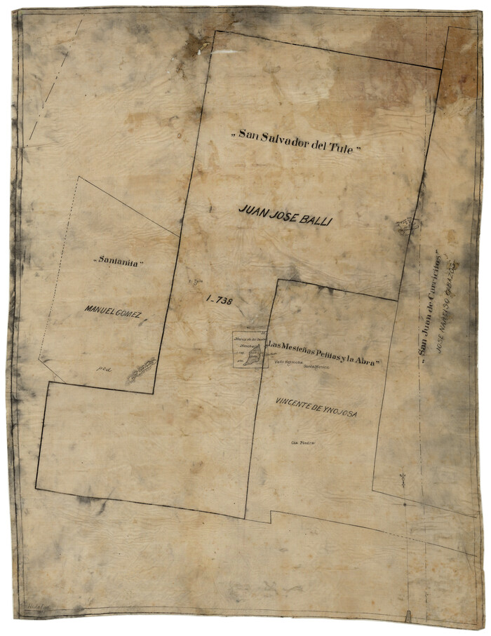
Print $20.00
- Digital $50.00
[Sketch of 'San Salvador del Tule', Juan Jose Balli Grant, Hidalgo County, Texas]
Size: 22.0 x 17.5 inches
10756
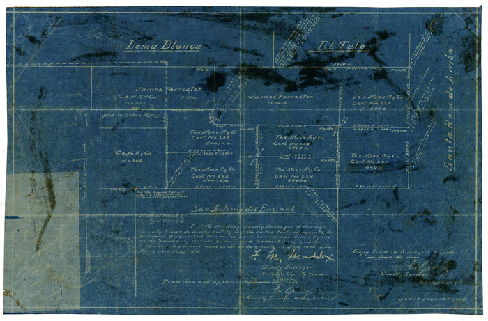
[Sketch Showing Loma Blanca , El Tule and San Antonio de Encinal Leagues in Brooks County, Texas]
Print $3.00
- Digital $50.00
[Sketch Showing Loma Blanca , El Tule and San Antonio de Encinal Leagues in Brooks County, Texas]
Size: 9.3 x 14.2 inches
624
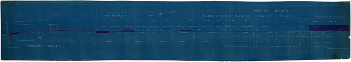
[Railroad Map of Falfurias to Hidalgo, Hidalgo County]
Print $40.00
- Digital $50.00
[Railroad Map of Falfurias to Hidalgo, Hidalgo County]
Size: 25.0 x 146.5 inches
89422
[Map of Hidalgo County]
Print $20.00
- Digital $50.00
[Map of Hidalgo County]
1882
Size: 26.0 x 19.9 inches
6207
[Map Showing Estivan Martinez "Los Nerios de Tio Ayola" Survey and Surveys North Thereof, Brooks County, Texas]
Print $20.00
- Digital $50.00
[Map Showing Estivan Martinez "Los Nerios de Tio Ayola" Survey and Surveys North Thereof, Brooks County, Texas]
1906
Size: 16.7 x 25.1 inches
10755
[Juan Jose Balli Survey, Kenedy County, Texas]
Print $3.00
- Digital $50.00
[Juan Jose Balli Survey, Kenedy County, Texas]
Size: 9.8 x 13.4 inches
4444
Starr County Sketch File 8

Print $7.00
- Digital $50.00
Starr County Sketch File 8
Size: 10.1 x 12.4 inches
36858
Starr County Sketch File 7

Print $20.00
- Digital $50.00
Starr County Sketch File 7
Size: 25.4 x 20.8 inches
12326
Starr County Sketch File 6

Print $20.00
- Digital $50.00
Starr County Sketch File 6
Size: 43.4 x 36.7 inches
10605
Starr County Sketch File 5

Print $40.00
- Digital $50.00
Starr County Sketch File 5
Size: 31.4 x 40.7 inches
82571
Starr County Sketch File 14

Print $40.00
- Digital $50.00
Starr County Sketch File 14
Size: 23.8 x 46.0 inches
4626
Starr County Rolled Sketch 46B

Print $20.00
- Digital $50.00
Starr County Rolled Sketch 46B
1986
Size: 17.9 x 34.5 inches
7838
Starr County Rolled Sketch 46A

Print $20.00
- Digital $50.00
Starr County Rolled Sketch 46A
1986
Size: 17.9 x 34.4 inches
7837
Starr County Rolled Sketch 12

Print $20.00
- Digital $50.00
Starr County Rolled Sketch 12
1912
Size: 19.5 x 15.5 inches
7799
Soil Map - Reconnoissance Survey - South Texas Sheet

Print $20.00
- Digital $50.00
Soil Map - Reconnoissance Survey - South Texas Sheet
1909
Size: 28.6 x 37.8 inches
97267
Rio Grande, Weslaco Sheet

Print $20.00
- Digital $50.00
Rio Grande, Weslaco Sheet
1937
Size: 37.3 x 37.1 inches
65125
Rio Grande, Santa Rosa Sheet

Print $20.00
- Digital $50.00
Rio Grande, Santa Rosa Sheet
1937
Size: 37.3 x 37.3 inches
65116
Rio Grande, Run Sheet

Print $2.00
- Digital $50.00
Rio Grande, Run Sheet
1931
Size: 17.0 x 14.3 inches
65120
Rio Grande, Raymondville Sheet

Print $20.00
- Digital $50.00
Rio Grande, Raymondville Sheet
1937
Size: 37.3 x 37.9 inches
65110
Rio Grande, Raymondville Sheet

Print $20.00
- Digital $50.00
Rio Grande, Raymondville Sheet
1925
Size: 43.7 x 17.8 inches
65127
Rio Grande, Penitas Sheet

Print $20.00
- Digital $50.00
Rio Grande, Penitas Sheet
1937
Size: 40.2 x 42.9 inches
65119
Rio Grande, Penitas Sheet

Print $20.00
- Digital $50.00
Rio Grande, Penitas Sheet
1937
Size: 39.8 x 42.0 inches
69708
Rio Grande, North Extension McAllen Sheet

Print $20.00
- Digital $50.00
Rio Grande, North Extension McAllen Sheet
1937
Size: 18.5 x 42.1 inches
65108
Rio Grande, Mercedes and La Feria Sheet

Print $20.00
- Digital $50.00
Rio Grande, Mercedes and La Feria Sheet
1937
Size: 37.3 x 37.2 inches
65126
Rio Grande, McAllen Sheet

Print $20.00
- Digital $50.00
Rio Grande, McAllen Sheet
1937
Size: 37.4 x 37.5 inches
65118
Rio Grande, Madero Sheet

Print $20.00
- Digital $50.00
Rio Grande, Madero Sheet
1931
Size: 33.0 x 38.5 inches
65124
[Working Sketch of a portion of Hidalgo & Starr Co's.]
Print $20.00
- Digital $50.00
[Working Sketch of a portion of Hidalgo & Starr Co's.]
1906
-
Size
27.8 x 13.8 inches
-
Map/Doc
4447
-
Creation Date
1906
[Tex Mex & CCSDRG&G Railroad Blocks in Starr and Hidalgo Counties, Texas]
Print $20.00
- Digital $50.00
[Tex Mex & CCSDRG&G Railroad Blocks in Starr and Hidalgo Counties, Texas]
1906
-
Size
28.7 x 24.2 inches
-
Map/Doc
4452
-
Creation Date
1906
[Surveying Sketch of M. Farley, R. Word, S. S. Hervey, et al in Kleberg County, Texas]
Print $20.00
- Digital $50.00
[Surveying Sketch of M. Farley, R. Word, S. S. Hervey, et al in Kleberg County, Texas]
-
Size
23.2 x 40.6 inches
-
Map/Doc
10783
[Sketch of 'San Salvador del Tule', Juan Jose Balli Grant, Hidalgo County, Texas]
Print $20.00
- Digital $50.00
[Sketch of 'San Salvador del Tule', Juan Jose Balli Grant, Hidalgo County, Texas]
-
Size
22.0 x 17.5 inches
-
Map/Doc
10756
[Sketch Showing Loma Blanca , El Tule and San Antonio de Encinal Leagues in Brooks County, Texas]
Print $3.00
- Digital $50.00
[Sketch Showing Loma Blanca , El Tule and San Antonio de Encinal Leagues in Brooks County, Texas]
-
Size
9.3 x 14.2 inches
-
Map/Doc
624
[Railroad Map of Falfurias to Hidalgo, Hidalgo County]
Print $40.00
- Digital $50.00
[Railroad Map of Falfurias to Hidalgo, Hidalgo County]
-
Size
25.0 x 146.5 inches
-
Map/Doc
89422
[Map of Hidalgo County]
Print $20.00
- Digital $50.00
[Map of Hidalgo County]
1882
-
Size
26.0 x 19.9 inches
-
Map/Doc
6207
-
Creation Date
1882
[Map Showing Estivan Martinez "Los Nerios de Tio Ayola" Survey and Surveys North Thereof, Brooks County, Texas]
Print $20.00
- Digital $50.00
[Map Showing Estivan Martinez "Los Nerios de Tio Ayola" Survey and Surveys North Thereof, Brooks County, Texas]
1906
-
Size
16.7 x 25.1 inches
-
Map/Doc
10755
-
Creation Date
1906
[Juan Jose Balli Survey, Kenedy County, Texas]
Print $3.00
- Digital $50.00
[Juan Jose Balli Survey, Kenedy County, Texas]
-
Size
9.8 x 13.4 inches
-
Map/Doc
4444
[Hidalgo County]
![89517, [Hidalgo County], Barnes Railroad Collection](https://historictexasmaps.com/wmedia_w700/maps/89517.tif.jpg)
Print $20.00
- Digital $50.00
[Hidalgo County]
-
Size
44.7 x 26.0 inches
-
Map/Doc
89517
Starr County Sketch File 8
Print $7.00
- Digital $50.00
Starr County Sketch File 8
-
Size
10.1 x 12.4 inches
-
Map/Doc
36858
Starr County Sketch File 7
Print $20.00
- Digital $50.00
Starr County Sketch File 7
-
Size
25.4 x 20.8 inches
-
Map/Doc
12326
Starr County Sketch File 6
Print $20.00
- Digital $50.00
Starr County Sketch File 6
-
Size
43.4 x 36.7 inches
-
Map/Doc
10605
Starr County Sketch File 5
Print $40.00
- Digital $50.00
Starr County Sketch File 5
-
Size
31.4 x 40.7 inches
-
Map/Doc
82571
Starr County Sketch File 14
Print $40.00
- Digital $50.00
Starr County Sketch File 14
-
Size
23.8 x 46.0 inches
-
Map/Doc
4626
Starr County Rolled Sketch 46B
Print $20.00
- Digital $50.00
Starr County Rolled Sketch 46B
1986
-
Size
17.9 x 34.5 inches
-
Map/Doc
7838
-
Creation Date
1986
Starr County Rolled Sketch 46A
Print $20.00
- Digital $50.00
Starr County Rolled Sketch 46A
1986
-
Size
17.9 x 34.4 inches
-
Map/Doc
7837
-
Creation Date
1986
Starr County Rolled Sketch 12
Print $20.00
- Digital $50.00
Starr County Rolled Sketch 12
1912
-
Size
19.5 x 15.5 inches
-
Map/Doc
7799
-
Creation Date
1912
Soil Map - Reconnoissance Survey - South Texas Sheet
Print $20.00
- Digital $50.00
Soil Map - Reconnoissance Survey - South Texas Sheet
1909
-
Size
28.6 x 37.8 inches
-
Map/Doc
97267
-
Creation Date
1909
Rio Grande, Weslaco Sheet
Print $20.00
- Digital $50.00
Rio Grande, Weslaco Sheet
1937
-
Size
37.3 x 37.1 inches
-
Map/Doc
65125
-
Creation Date
1937
Rio Grande, Santa Rosa Sheet
Print $20.00
- Digital $50.00
Rio Grande, Santa Rosa Sheet
1937
-
Size
37.3 x 37.3 inches
-
Map/Doc
65116
-
Creation Date
1937
Rio Grande, Run Sheet
Print $2.00
- Digital $50.00
Rio Grande, Run Sheet
1931
-
Size
17.0 x 14.3 inches
-
Map/Doc
65120
-
Creation Date
1931
Rio Grande, Raymondville Sheet
Print $20.00
- Digital $50.00
Rio Grande, Raymondville Sheet
1937
-
Size
37.3 x 37.9 inches
-
Map/Doc
65110
-
Creation Date
1937
Rio Grande, Raymondville Sheet
Print $20.00
- Digital $50.00
Rio Grande, Raymondville Sheet
1925
-
Size
43.7 x 17.8 inches
-
Map/Doc
65127
-
Creation Date
1925
Rio Grande, Penitas Sheet
Print $20.00
- Digital $50.00
Rio Grande, Penitas Sheet
1937
-
Size
40.2 x 42.9 inches
-
Map/Doc
65119
-
Creation Date
1937
Rio Grande, Penitas Sheet
Print $20.00
- Digital $50.00
Rio Grande, Penitas Sheet
1937
-
Size
39.8 x 42.0 inches
-
Map/Doc
69708
-
Creation Date
1937
Rio Grande, North Extension McAllen Sheet
Print $20.00
- Digital $50.00
Rio Grande, North Extension McAllen Sheet
1937
-
Size
18.5 x 42.1 inches
-
Map/Doc
65108
-
Creation Date
1937
Rio Grande, Mercedes and La Feria Sheet
Print $20.00
- Digital $50.00
Rio Grande, Mercedes and La Feria Sheet
1937
-
Size
37.3 x 37.2 inches
-
Map/Doc
65126
-
Creation Date
1937
Rio Grande, McAllen Sheet
Print $20.00
- Digital $50.00
Rio Grande, McAllen Sheet
1937
-
Size
37.4 x 37.5 inches
-
Map/Doc
65118
-
Creation Date
1937
Rio Grande, Madero Sheet
Print $20.00
- Digital $50.00
Rio Grande, Madero Sheet
1931
-
Size
33.0 x 38.5 inches
-
Map/Doc
65124
-
Creation Date
1931