Foard County Sketch File 2

Print $40.00
- Digital $50.00
Foard County Sketch File 2
Size: 23.8 x 16.3 inches
11490
Jack County Sketch File 18c

Print $60.00
- Digital $50.00
Jack County Sketch File 18c
Size: 20.0 x 30.7 inches
11828
Jack County Sketch File 30

Print $20.00
- Digital $50.00
Jack County Sketch File 30
Size: 24.9 x 34.7 inches
11829
Jack County Sketch File 33

Print $20.00
- Digital $50.00
Jack County Sketch File 33
Size: 19.5 x 21.4 inches
11831
Jack County Sketch File 34

Print $20.00
- Digital $50.00
Jack County Sketch File 34
1951
Size: 21.2 x 29.3 inches
11832
Jack County Sketch File 35

Print $20.00
- Digital $50.00
Jack County Sketch File 35
1958
Size: 23.9 x 35.6 inches
11833
Palo Pinto County Sketch File 21

Print $20.00
- Digital $50.00
Palo Pinto County Sketch File 21
1896
Size: 18.5 x 17.5 inches
12133
Parker County Sketch File 27

Print $20.00
- Digital $50.00
Parker County Sketch File 27
1876
Size: 23.7 x 23.8 inches
12146
Wise County Sketch File F

Print $20.00
- Digital $50.00
Wise County Sketch File F
1857
Size: 16.2 x 29.2 inches
12704
Map of Jack County

Print $40.00
- Digital $50.00
Map of Jack County
1895
Size: 49.7 x 37.2 inches
16858
Clay County Sketch File 4

Print $22.00
- Digital $50.00
Clay County Sketch File 4
1854
Size: 5.0 x 7.5 inches
18392
Map of The Surveyed Part of Peters Colony Texas

Print $40.00
- Digital $50.00
Map of The Surveyed Part of Peters Colony Texas
1854
Size: 53.5 x 65.9 inches
1967
Sketch showing the Connnecting Lines run by Olliver Hedgcoxe for the Texan Emigration and Land Company connecting their Surveys made by them in Peters' Colony, Texas

Print $40.00
- Digital $50.00
Sketch showing the Connnecting Lines run by Olliver Hedgcoxe for the Texan Emigration and Land Company connecting their Surveys made by them in Peters' Colony, Texas
1854
Size: 45.8 x 61.9 inches
1969
Map of Cooke County

Print $20.00
- Digital $50.00
Map of Cooke County
1857
Size: 34.1 x 37.9 inches
1973
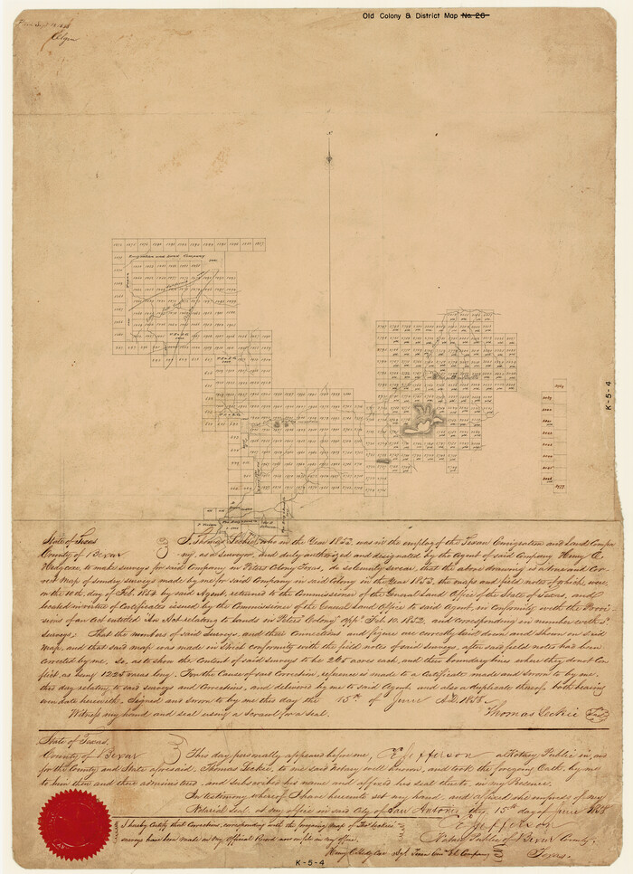
[Surveys made in Peters Colony by Thomas Leckie]
Print $20.00
- Digital $50.00
[Surveys made in Peters Colony by Thomas Leckie]
1858
Size: 22.9 x 16.6 inches
1983
Jack County Sketch File 1

Print $4.00
- Digital $50.00
Jack County Sketch File 1
Size: 8.4 x 6.4 inches
27499
Jack County Sketch File 2

Print $6.00
- Digital $50.00
Jack County Sketch File 2
1856
Size: 8.8 x 8.0 inches
27501
Jack County Sketch File 3

Print $6.00
- Digital $50.00
Jack County Sketch File 3
1857
Size: 10.6 x 16.5 inches
27504
Jack County Sketch File 4

Print $4.00
- Digital $50.00
Jack County Sketch File 4
1857
Size: 9.0 x 12.7 inches
27506
Jack County Sketch File 5

Print $6.00
- Digital $50.00
Jack County Sketch File 5
1875
Size: 11.0 x 10.8 inches
27508
Jack County Sketch File 5a

Print $6.00
- Digital $50.00
Jack County Sketch File 5a
1856
Size: 8.6 x 9.8 inches
27510
Jack County Sketch File 6

Print $8.00
- Digital $50.00
Jack County Sketch File 6
1856
Size: 8.2 x 3.5 inches
27513
Jack County Sketch File 7

Print $6.00
- Digital $50.00
Jack County Sketch File 7
1857
Size: 6.7 x 12.4 inches
27516
Jack County Sketch File 8a

Print $6.00
- Digital $50.00
Jack County Sketch File 8a
1855
Size: 8.1 x 10.6 inches
27519
Jack County Sketch File 9a

Print $6.00
- Digital $50.00
Jack County Sketch File 9a
1857
Size: 12.5 x 7.8 inches
27522
Jack County Sketch File 9b

Print $4.00
- Digital $50.00
Jack County Sketch File 9b
1856
Size: 8.2 x 13.5 inches
27525
Jack County Sketch File 10

Print $4.00
- Digital $50.00
Jack County Sketch File 10
1857
Size: 12.4 x 8.3 inches
27527
Jack County Sketch File 10a

Print $4.00
- Digital $50.00
Jack County Sketch File 10a
1858
Size: 13.8 x 8.3 inches
27529
Jack County Sketch File 11

Print $4.00
- Digital $50.00
Jack County Sketch File 11
1858
Size: 10.2 x 8.1 inches
27531
Foard County Sketch File 2
Print $40.00
- Digital $50.00
Foard County Sketch File 2
-
Size
23.8 x 16.3 inches
-
Map/Doc
11490
Jack County Sketch File 18c
Print $60.00
- Digital $50.00
Jack County Sketch File 18c
-
Size
20.0 x 30.7 inches
-
Map/Doc
11828
Jack County Sketch File 30
Print $20.00
- Digital $50.00
Jack County Sketch File 30
-
Size
24.9 x 34.7 inches
-
Map/Doc
11829
Jack County Sketch File 33
Print $20.00
- Digital $50.00
Jack County Sketch File 33
-
Size
19.5 x 21.4 inches
-
Map/Doc
11831
Jack County Sketch File 34
Print $20.00
- Digital $50.00
Jack County Sketch File 34
1951
-
Size
21.2 x 29.3 inches
-
Map/Doc
11832
-
Creation Date
1951
Jack County Sketch File 35
Print $20.00
- Digital $50.00
Jack County Sketch File 35
1958
-
Size
23.9 x 35.6 inches
-
Map/Doc
11833
-
Creation Date
1958
Palo Pinto County Sketch File 21
Print $20.00
- Digital $50.00
Palo Pinto County Sketch File 21
1896
-
Size
18.5 x 17.5 inches
-
Map/Doc
12133
-
Creation Date
1896
Parker County Sketch File 27
Print $20.00
- Digital $50.00
Parker County Sketch File 27
1876
-
Size
23.7 x 23.8 inches
-
Map/Doc
12146
-
Creation Date
1876
Wise County Sketch File F
Print $20.00
- Digital $50.00
Wise County Sketch File F
1857
-
Size
16.2 x 29.2 inches
-
Map/Doc
12704
-
Creation Date
1857
Map of Jack County
Print $40.00
- Digital $50.00
Map of Jack County
1895
-
Size
49.7 x 37.2 inches
-
Map/Doc
16858
-
Creation Date
1895
Clay County Sketch File 4
Print $22.00
- Digital $50.00
Clay County Sketch File 4
1854
-
Size
5.0 x 7.5 inches
-
Map/Doc
18392
-
Creation Date
1854
Jack County

Print $20.00
- Digital $50.00
Jack County
1925
-
Size
47.7 x 36.9 inches
-
Map/Doc
1865
-
Creation Date
1925
Map of The Surveyed Part of Peters Colony Texas
Print $40.00
- Digital $50.00
Map of The Surveyed Part of Peters Colony Texas
1854
-
Size
53.5 x 65.9 inches
-
Map/Doc
1967
-
Creation Date
1854
Sketch showing the Connnecting Lines run by Olliver Hedgcoxe for the Texan Emigration and Land Company connecting their Surveys made by them in Peters' Colony, Texas
Print $40.00
- Digital $50.00
Sketch showing the Connnecting Lines run by Olliver Hedgcoxe for the Texan Emigration and Land Company connecting their Surveys made by them in Peters' Colony, Texas
1854
-
Size
45.8 x 61.9 inches
-
Map/Doc
1969
-
Creation Date
1854
Map of Cooke County
Print $20.00
- Digital $50.00
Map of Cooke County
1857
-
Size
34.1 x 37.9 inches
-
Map/Doc
1973
-
Creation Date
1857
[Surveys made in Peters Colony by Thomas Leckie]
Print $20.00
- Digital $50.00
[Surveys made in Peters Colony by Thomas Leckie]
1858
-
Size
22.9 x 16.6 inches
-
Map/Doc
1983
-
Creation Date
1858
Jack County Sketch File 1
Print $4.00
- Digital $50.00
Jack County Sketch File 1
-
Size
8.4 x 6.4 inches
-
Map/Doc
27499
Jack County Sketch File 2
Print $6.00
- Digital $50.00
Jack County Sketch File 2
1856
-
Size
8.8 x 8.0 inches
-
Map/Doc
27501
-
Creation Date
1856
Jack County Sketch File 3
Print $6.00
- Digital $50.00
Jack County Sketch File 3
1857
-
Size
10.6 x 16.5 inches
-
Map/Doc
27504
-
Creation Date
1857
Jack County Sketch File 4
Print $4.00
- Digital $50.00
Jack County Sketch File 4
1857
-
Size
9.0 x 12.7 inches
-
Map/Doc
27506
-
Creation Date
1857
Jack County Sketch File 5
Print $6.00
- Digital $50.00
Jack County Sketch File 5
1875
-
Size
11.0 x 10.8 inches
-
Map/Doc
27508
-
Creation Date
1875
Jack County Sketch File 5a
Print $6.00
- Digital $50.00
Jack County Sketch File 5a
1856
-
Size
8.6 x 9.8 inches
-
Map/Doc
27510
-
Creation Date
1856
Jack County Sketch File 6
Print $8.00
- Digital $50.00
Jack County Sketch File 6
1856
-
Size
8.2 x 3.5 inches
-
Map/Doc
27513
-
Creation Date
1856
Jack County Sketch File 7
Print $6.00
- Digital $50.00
Jack County Sketch File 7
1857
-
Size
6.7 x 12.4 inches
-
Map/Doc
27516
-
Creation Date
1857
Jack County Sketch File 8a
Print $6.00
- Digital $50.00
Jack County Sketch File 8a
1855
-
Size
8.1 x 10.6 inches
-
Map/Doc
27519
-
Creation Date
1855
Jack County Sketch File 9a
Print $6.00
- Digital $50.00
Jack County Sketch File 9a
1857
-
Size
12.5 x 7.8 inches
-
Map/Doc
27522
-
Creation Date
1857
Jack County Sketch File 9b
Print $4.00
- Digital $50.00
Jack County Sketch File 9b
1856
-
Size
8.2 x 13.5 inches
-
Map/Doc
27525
-
Creation Date
1856
Jack County Sketch File 10
Print $4.00
- Digital $50.00
Jack County Sketch File 10
1857
-
Size
12.4 x 8.3 inches
-
Map/Doc
27527
-
Creation Date
1857
Jack County Sketch File 10a
Print $4.00
- Digital $50.00
Jack County Sketch File 10a
1858
-
Size
13.8 x 8.3 inches
-
Map/Doc
27529
-
Creation Date
1858
Jack County Sketch File 11
Print $4.00
- Digital $50.00
Jack County Sketch File 11
1858
-
Size
10.2 x 8.1 inches
-
Map/Doc
27531
-
Creation Date
1858