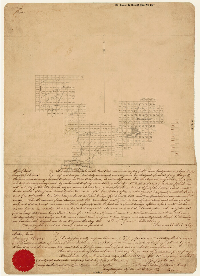
[Surveys made in Peters Colony by Thomas Leckie]
Print $20.00
- Digital $50.00
[Surveys made in Peters Colony by Thomas Leckie]
1858
Size: 22.9 x 16.6 inches
1983
Young County Working Sketch 14

Print $20.00
- Digital $50.00
Young County Working Sketch 14
1944
Size: 15.3 x 16.0 inches
62037
Young County Rolled Sketch 18

Print $20.00
- Digital $50.00
Young County Rolled Sketch 18
2020
Size: 22.6 x 30.4 inches
95960
Wise County Sketch File F

Print $20.00
- Digital $50.00
Wise County Sketch File F
1857
Size: 16.2 x 29.2 inches
12704
Wise County Sketch File 7

Print $4.00
- Digital $50.00
Wise County Sketch File 7
1857
Size: 8.1 x 14.0 inches
40535
Wise County Sketch File 51

Print $2.00
- Digital $50.00
Wise County Sketch File 51
Size: 8.5 x 3.9 inches
40618
Wise County Sketch File 29

Print $20.00
- Digital $50.00
Wise County Sketch File 29
1857
Size: 11.1 x 20.7 inches
76762
Wise County Sketch File 2

Print $8.00
- Digital $50.00
Wise County Sketch File 2
1856
Size: 8.2 x 13.4 inches
40523
Sketch showing the Connnecting Lines run by Olliver Hedgcoxe for the Texan Emigration and Land Company connecting their Surveys made by them in Peters' Colony, Texas

Print $40.00
- Digital $50.00
Sketch showing the Connnecting Lines run by Olliver Hedgcoxe for the Texan Emigration and Land Company connecting their Surveys made by them in Peters' Colony, Texas
1854
Size: 45.8 x 61.9 inches
1969
Parker County Sketch File 27

Print $20.00
- Digital $50.00
Parker County Sketch File 27
1876
Size: 23.7 x 23.8 inches
12146
Palo Pinto County Working Sketch 24

Print $20.00
- Digital $50.00
Palo Pinto County Working Sketch 24
1990
71407
Palo Pinto County Sketch File 21

Print $20.00
- Digital $50.00
Palo Pinto County Sketch File 21
1896
Size: 18.5 x 17.5 inches
12133
Palo Pinto County Sketch File 20

Print $6.00
- Digital $50.00
Palo Pinto County Sketch File 20
1891
Size: 12.5 x 10.9 inches
33402
Map showing lands surveyed by Sylvan Sanders in the Southwestern Part of Jack County, Texas for Buttram Petroleum Corporation

Print $20.00
- Digital $50.00
Map showing lands surveyed by Sylvan Sanders in the Southwestern Part of Jack County, Texas for Buttram Petroleum Corporation
1926
Size: 29.3 x 25.6 inches
92159
Map showing lands surveyed by Sylvan Sanders in the Southwestern Part of Jack County, Texas for Buttram Petroleum Corporation

Print $20.00
- Digital $50.00
Map showing lands surveyed by Sylvan Sanders in the Southwestern Part of Jack County, Texas for Buttram Petroleum Corporation
Size: 21.2 x 12.9 inches
92186
Map of the Recognised Line, M. El. P. & P. RR. from Texas & Arkansas State Line to Milam & Bexar Land District Line

Print $40.00
- Digital $50.00
Map of the Recognised Line, M. El. P. & P. RR. from Texas & Arkansas State Line to Milam & Bexar Land District Line
Size: 15.3 x 89.4 inches
64638
Map of the Fort Worth and Denver City Railway

Print $40.00
- Digital $50.00
Map of the Fort Worth and Denver City Railway
1873
Size: 31.6 x 90.3 inches
64778
Map of The Surveyed Part of Peters Colony Texas

Print $40.00
- Digital $50.00
Map of The Surveyed Part of Peters Colony Texas
1854
Size: 53.5 x 65.9 inches
1967
Map of The Surveyed Part of Peters Colony Texas

Print $40.00
- Digital $50.00
Map of The Surveyed Part of Peters Colony Texas
1854
Size: 53.7 x 32.0 inches
83007
Map of The Surveyed Part of Peters Colony Texas

Print $40.00
- Digital $50.00
Map of The Surveyed Part of Peters Colony Texas
1854
Size: 53.1 x 33.9 inches
83008
Map of Jack County

Print $40.00
- Digital $50.00
Map of Jack County
1895
Size: 49.7 x 37.2 inches
16858
Map of Jack County

Print $20.00
- Digital $50.00
Map of Jack County
1896
Size: 20.3 x 17.7 inches
3699
Map of Jack County

Print $20.00
- Digital $50.00
Map of Jack County
1868
Size: 23.8 x 19.8 inches
3701
Map of Jack County

Print $20.00
- Digital $50.00
Map of Jack County
1874
Size: 20.7 x 17.6 inches
3704
Map of Jack County

Print $20.00
- Digital $50.00
Map of Jack County
1882
Size: 21.6 x 24.5 inches
3706
Map of Jack County

Print $20.00
- Digital $50.00
Map of Jack County
1896
Size: 22.7 x 27.4 inches
4571
Map of Jack County

Print $20.00
- Digital $50.00
Map of Jack County
1895
Size: 47.6 x 38.0 inches
4988
Map of Jack County

Print $20.00
- Digital $50.00
Map of Jack County
1896
Size: 43.6 x 38.9 inches
66877
[Surveys made in Peters Colony by Thomas Leckie]
Print $20.00
- Digital $50.00
[Surveys made in Peters Colony by Thomas Leckie]
1858
-
Size
22.9 x 16.6 inches
-
Map/Doc
1983
-
Creation Date
1858
Young County Working Sketch 14
Print $20.00
- Digital $50.00
Young County Working Sketch 14
1944
-
Size
15.3 x 16.0 inches
-
Map/Doc
62037
-
Creation Date
1944
Young County Rolled Sketch 18
Print $20.00
- Digital $50.00
Young County Rolled Sketch 18
2020
-
Size
22.6 x 30.4 inches
-
Map/Doc
95960
-
Creation Date
2020
Wise County Sketch File F
Print $20.00
- Digital $50.00
Wise County Sketch File F
1857
-
Size
16.2 x 29.2 inches
-
Map/Doc
12704
-
Creation Date
1857
Wise County Sketch File 7
Print $4.00
- Digital $50.00
Wise County Sketch File 7
1857
-
Size
8.1 x 14.0 inches
-
Map/Doc
40535
-
Creation Date
1857
Wise County Sketch File 51
Print $2.00
- Digital $50.00
Wise County Sketch File 51
-
Size
8.5 x 3.9 inches
-
Map/Doc
40618
Wise County Sketch File 29
Print $20.00
- Digital $50.00
Wise County Sketch File 29
1857
-
Size
11.1 x 20.7 inches
-
Map/Doc
76762
-
Creation Date
1857
Wise County Sketch File 2
Print $8.00
- Digital $50.00
Wise County Sketch File 2
1856
-
Size
8.2 x 13.4 inches
-
Map/Doc
40523
-
Creation Date
1856
Sketch showing the Connnecting Lines run by Olliver Hedgcoxe for the Texan Emigration and Land Company connecting their Surveys made by them in Peters' Colony, Texas
Print $40.00
- Digital $50.00
Sketch showing the Connnecting Lines run by Olliver Hedgcoxe for the Texan Emigration and Land Company connecting their Surveys made by them in Peters' Colony, Texas
1854
-
Size
45.8 x 61.9 inches
-
Map/Doc
1969
-
Creation Date
1854
Parker County Sketch File 27
Print $20.00
- Digital $50.00
Parker County Sketch File 27
1876
-
Size
23.7 x 23.8 inches
-
Map/Doc
12146
-
Creation Date
1876
Palo Pinto County Working Sketch 24
Print $20.00
- Digital $50.00
Palo Pinto County Working Sketch 24
1990
-
Map/Doc
71407
-
Creation Date
1990
Palo Pinto County Sketch File 21
Print $20.00
- Digital $50.00
Palo Pinto County Sketch File 21
1896
-
Size
18.5 x 17.5 inches
-
Map/Doc
12133
-
Creation Date
1896
Palo Pinto County Sketch File 20
Print $6.00
- Digital $50.00
Palo Pinto County Sketch File 20
1891
-
Size
12.5 x 10.9 inches
-
Map/Doc
33402
-
Creation Date
1891
Map showing lands surveyed by Sylvan Sanders in the Southwestern Part of Jack County, Texas for Buttram Petroleum Corporation
Print $20.00
- Digital $50.00
Map showing lands surveyed by Sylvan Sanders in the Southwestern Part of Jack County, Texas for Buttram Petroleum Corporation
1926
-
Size
29.3 x 25.6 inches
-
Map/Doc
92159
-
Creation Date
1926
Map showing lands surveyed by Sylvan Sanders in the Southwestern Part of Jack County, Texas for Buttram Petroleum Corporation
Print $20.00
- Digital $50.00
Map showing lands surveyed by Sylvan Sanders in the Southwestern Part of Jack County, Texas for Buttram Petroleum Corporation
-
Size
21.2 x 12.9 inches
-
Map/Doc
92186
Map of the Recognised Line, M. El. P. & P. RR. from Texas & Arkansas State Line to Milam & Bexar Land District Line
Print $40.00
- Digital $50.00
Map of the Recognised Line, M. El. P. & P. RR. from Texas & Arkansas State Line to Milam & Bexar Land District Line
-
Size
15.3 x 89.4 inches
-
Map/Doc
64638
Map of the Fort Worth and Denver City Railway
Print $40.00
- Digital $50.00
Map of the Fort Worth and Denver City Railway
1873
-
Size
31.6 x 90.3 inches
-
Map/Doc
64778
-
Creation Date
1873
Map of The Surveyed Part of Peters Colony Texas
Print $40.00
- Digital $50.00
Map of The Surveyed Part of Peters Colony Texas
1854
-
Size
53.5 x 65.9 inches
-
Map/Doc
1967
-
Creation Date
1854
Map of The Surveyed Part of Peters Colony Texas
Print $40.00
- Digital $50.00
Map of The Surveyed Part of Peters Colony Texas
1854
-
Size
53.7 x 32.0 inches
-
Map/Doc
83007
-
Creation Date
1854
Map of The Surveyed Part of Peters Colony Texas
Print $40.00
- Digital $50.00
Map of The Surveyed Part of Peters Colony Texas
1854
-
Size
53.1 x 33.9 inches
-
Map/Doc
83008
-
Creation Date
1854
Map of Jack County
Print $40.00
- Digital $50.00
Map of Jack County
1895
-
Size
49.7 x 37.2 inches
-
Map/Doc
16858
-
Creation Date
1895
Map of Jack County
Print $20.00
- Digital $50.00
Map of Jack County
1896
-
Size
20.3 x 17.7 inches
-
Map/Doc
3699
-
Creation Date
1896
Map of Jack County
Print $20.00
- Digital $50.00
Map of Jack County
1868
-
Size
23.8 x 19.8 inches
-
Map/Doc
3701
-
Creation Date
1868
Map of Jack County

Print $20.00
- Digital $50.00
Map of Jack County
-
Size
18.4 x 15.9 inches
-
Map/Doc
3702
Map of Jack County

Print $20.00
- Digital $50.00
Map of Jack County
-
Size
18.7 x 15.9 inches
-
Map/Doc
3703
Map of Jack County
Print $20.00
- Digital $50.00
Map of Jack County
1874
-
Size
20.7 x 17.6 inches
-
Map/Doc
3704
-
Creation Date
1874
Map of Jack County
Print $20.00
- Digital $50.00
Map of Jack County
1882
-
Size
21.6 x 24.5 inches
-
Map/Doc
3706
-
Creation Date
1882
Map of Jack County
Print $20.00
- Digital $50.00
Map of Jack County
1896
-
Size
22.7 x 27.4 inches
-
Map/Doc
4571
-
Creation Date
1896
Map of Jack County
Print $20.00
- Digital $50.00
Map of Jack County
1895
-
Size
47.6 x 38.0 inches
-
Map/Doc
4988
-
Creation Date
1895
Map of Jack County
Print $20.00
- Digital $50.00
Map of Jack County
1896
-
Size
43.6 x 38.9 inches
-
Map/Doc
66877
-
Creation Date
1896