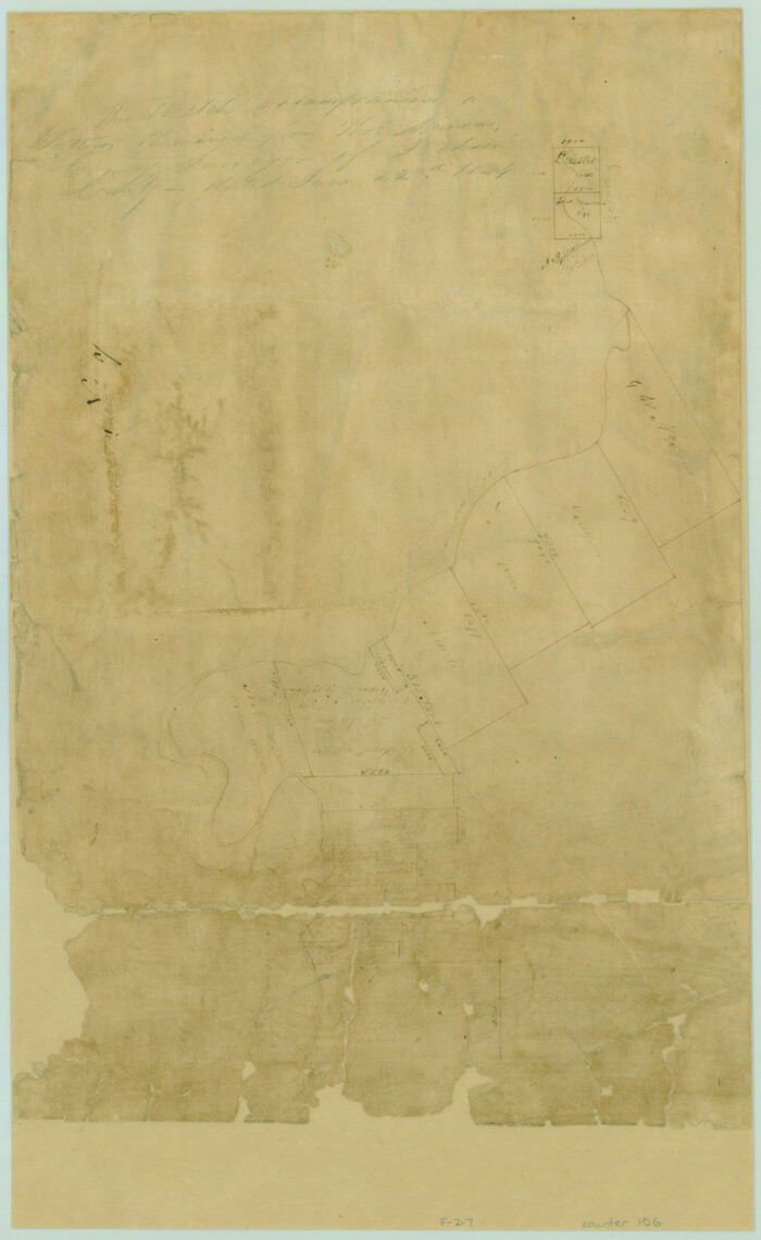
[Surveys near Carancahua Bay]
Print $2.00
- Digital $50.00
[Surveys near Carancahua Bay]
1844
Size: 13.1 x 8.0 inches
106
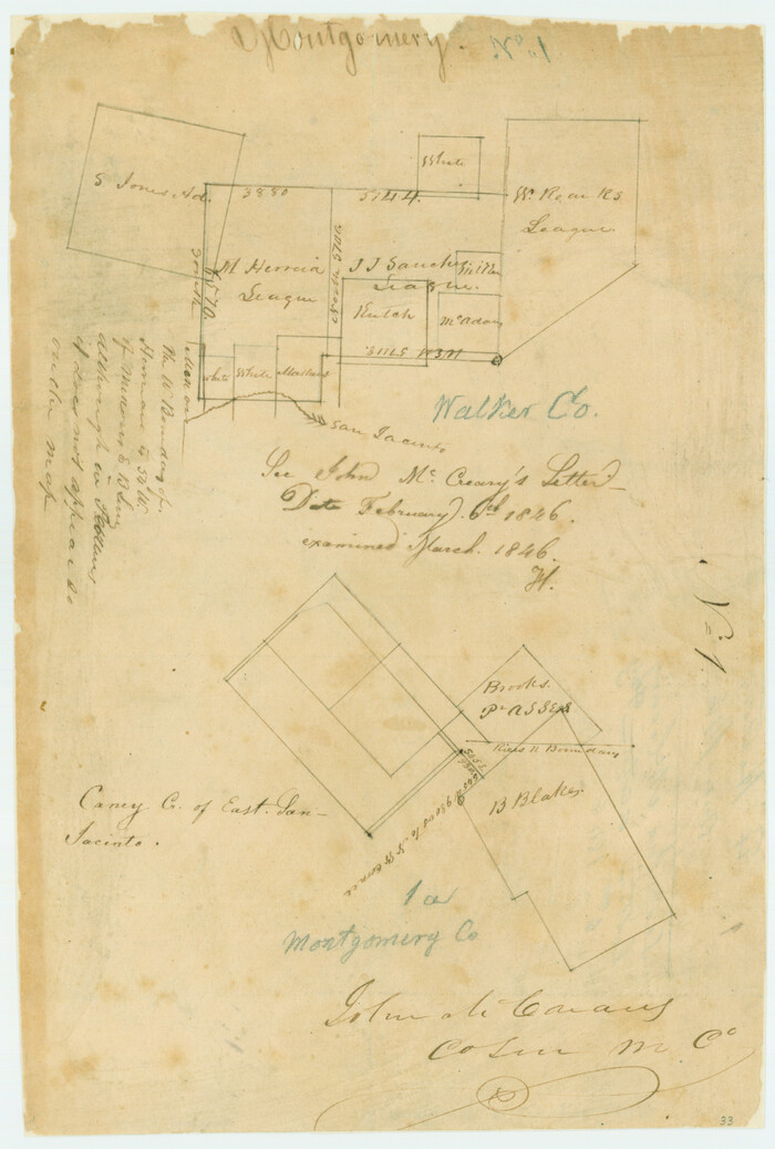
[Surveys in the Montgomery District: San Jacinto River and Caney Creek, Navidad, Navasota]
Print $2.00
- Digital $50.00
[Surveys in the Montgomery District: San Jacinto River and Caney Creek, Navidad, Navasota]
1846
Size: 8.8 x 6.0 inches
33
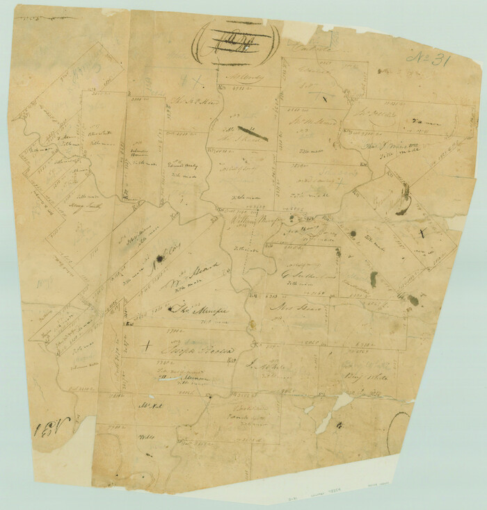
[Surveys in Jackson County]
Print $20.00
- Digital $50.00
[Surveys in Jackson County]
Size: 20.2 x 19.3 inches
78354
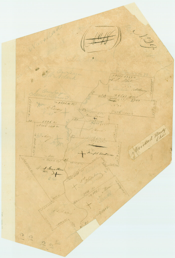
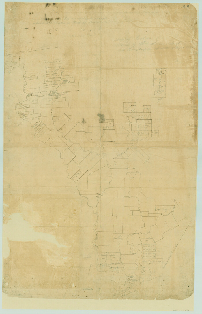
[Surveys in Austin's Colony on both sides of the Navidad River]
Print $20.00
- Digital $50.00
[Surveys in Austin's Colony on both sides of the Navidad River]
1831
Size: 18.8 x 12.7 inches
217
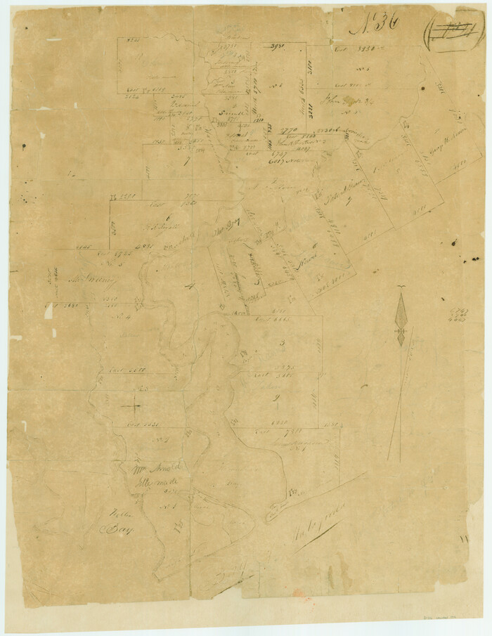
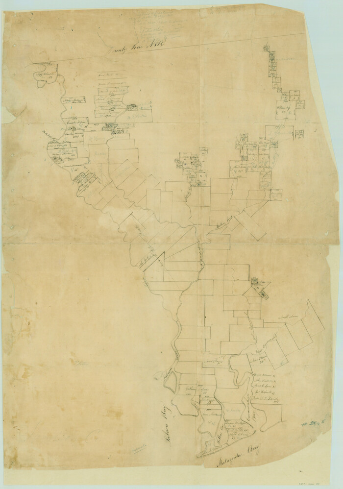
[Surveys in Austin's Colony at Carancahua Bay]
Print $20.00
- Digital $50.00
[Surveys in Austin's Colony at Carancahua Bay]
Size: 22.5 x 17.4 inches
172
[Surveys in Austin's Colony along the east bank of the Navidad River]
Print $20.00
- Digital $50.00
[Surveys in Austin's Colony along the east bank of the Navidad River]
1827
Size: 20.2 x 16.1 inches
211
[Surveys in Austin's Colony along the east bank of the Navidad River]
Print $20.00
- Digital $50.00
[Surveys in Austin's Colony along the east bank of the Navidad River]
1827
Size: 20.3 x 16.1 inches
78488
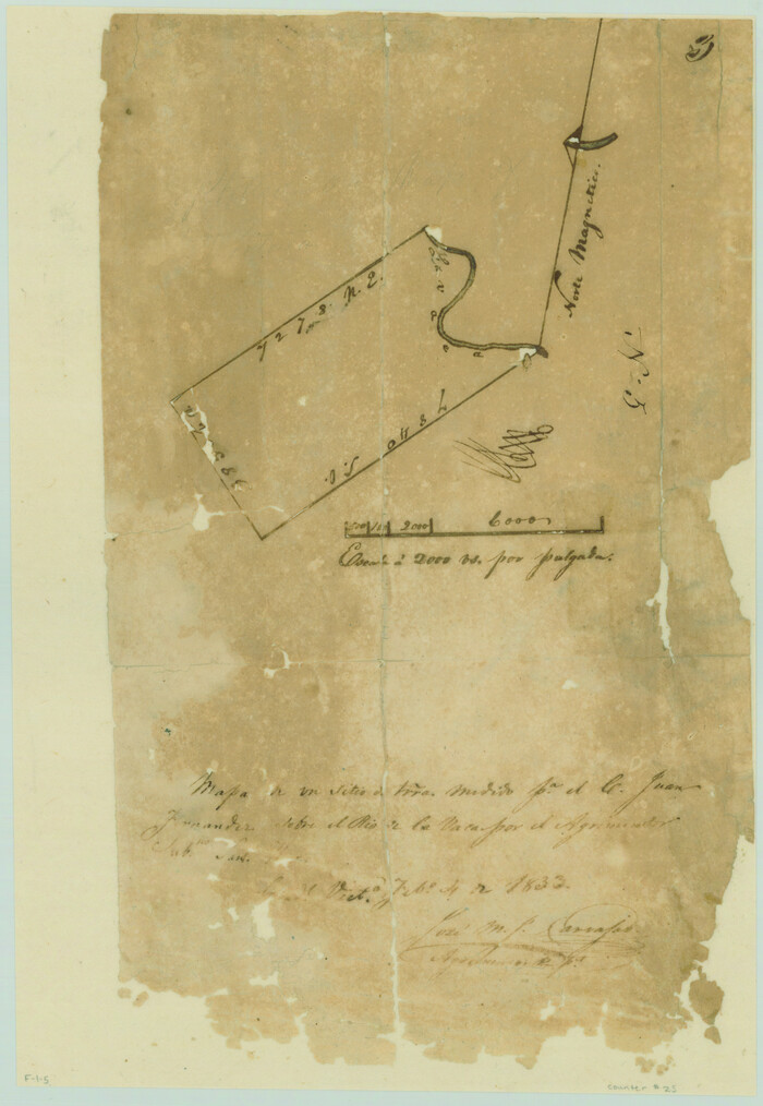
[Surveys along the Lavaca River]
Print $2.00
- Digital $50.00
[Surveys along the Lavaca River]
1833
Size: 12.9 x 8.9 inches
25
[Plat of All Surveys on Lavaca Not Heretofor Returned]
Print $20.00
- Digital $50.00
[Plat of All Surveys on Lavaca Not Heretofor Returned]
1841
Size: 31.3 x 22.0 inches
283
[Map of Jackson County]
Print $20.00
- Digital $50.00
[Map of Jackson County]
1836
Size: 32.8 x 21.1 inches
78359
Wharton County Working Sketch 20

Print $20.00
- Digital $50.00
Wharton County Working Sketch 20
1938
Size: 39.1 x 42.2 inches
72484
Wharton County Working Sketch 1

Print $20.00
- Digital $50.00
Wharton County Working Sketch 1
Size: 23.3 x 21.4 inches
72465
Wharton County Sketch File 19

Print $6.00
- Digital $50.00
Wharton County Sketch File 19
Size: 13.2 x 8.1 inches
39978
Wharton County Sketch File 17

Print $12.00
- Digital $50.00
Wharton County Sketch File 17
1898
Size: 12.8 x 8.1 inches
39969
Wharton County Sketch File 13

Print $26.00
- Digital $50.00
Wharton County Sketch File 13
1894
Size: 14.0 x 8.7 inches
39935
Wharton County Sketch File 12

Print $20.00
- Digital $50.00
Wharton County Sketch File 12
Size: 18.9 x 23.3 inches
12661
Wharton County Sketch File 11

Print $4.00
- Digital $50.00
Wharton County Sketch File 11
1891
Size: 9.1 x 12.3 inches
39933
Wharton County Sketch File 10a

Print $20.00
- Digital $50.00
Wharton County Sketch File 10a
Size: 11.0 x 19.0 inches
12660
Wharton County Rolled Sketch 6

Print $20.00
- Digital $50.00
Wharton County Rolled Sketch 6
1901
Size: 23.7 x 30.0 inches
8230
Wharton County Rolled Sketch 5

Print $20.00
- Digital $50.00
Wharton County Rolled Sketch 5
1899
Size: 19.3 x 24.6 inches
8229
Wharton County Rolled Sketch 3

Print $20.00
- Digital $50.00
Wharton County Rolled Sketch 3
Size: 28.9 x 31.4 inches
8228
Victoria County Sketch File 5

Print $4.00
- Digital $50.00
Victoria County Sketch File 5
1877
Size: 14.5 x 8.8 inches
39520
Victoria County Sketch File 3

Print $7.00
- Digital $50.00
Victoria County Sketch File 3
1876
Size: 10.1 x 8.2 inches
39514
Topographical Map of the country between San Antonio & Colorado Rivers in the State of Texas.

Print $40.00
Topographical Map of the country between San Antonio & Colorado Rivers in the State of Texas.
1864
Size: 53.3 x 69.2 inches
88604
Topographical Map of the country between San Antonio & Colorado Rivers in the State of Texas.

Print $40.00
Topographical Map of the country between San Antonio & Colorado Rivers in the State of Texas.
1864
Size: 53.4 x 69.8 inches
88605
The Republic County of Jackson. Spring 1842

Print $20.00
The Republic County of Jackson. Spring 1842
2020
Size: 15.6 x 21.8 inches
96190
The Republic County of Jackson. September 17, 1838

Print $20.00
The Republic County of Jackson. September 17, 1838
2020
Size: 15.6 x 21.8 inches
96185
The Republic County of Jackson. January 29, 1842

Print $20.00
The Republic County of Jackson. January 29, 1842
2020
Size: 15.6 x 21.8 inches
96189
The Republic County of Jackson. January 19, 1841

Print $20.00
The Republic County of Jackson. January 19, 1841
2020
Size: 15.6 x 21.8 inches
96188
[Victoria District]
![1945, [Victoria District], General Map Collection](https://historictexasmaps.com/wmedia_w700/maps/1945.tif.jpg)
Print $20.00
- Digital $50.00
[Victoria District]
-
Size
34.8 x 25.6 inches
-
Map/Doc
1945
[Surveys near Carancahua Bay]
Print $2.00
- Digital $50.00
[Surveys near Carancahua Bay]
1844
-
Size
13.1 x 8.0 inches
-
Map/Doc
106
-
Creation Date
1844
[Surveys in the Montgomery District: San Jacinto River and Caney Creek, Navidad, Navasota]
Print $2.00
- Digital $50.00
[Surveys in the Montgomery District: San Jacinto River and Caney Creek, Navidad, Navasota]
1846
-
Size
8.8 x 6.0 inches
-
Map/Doc
33
-
Creation Date
1846
[Surveys in Jackson County]
Print $20.00
- Digital $50.00
[Surveys in Jackson County]
-
Size
20.2 x 19.3 inches
-
Map/Doc
78354
[Surveys in Austin's Colony on both sides of the Navidad River]
Print $20.00
- Digital $50.00
[Surveys in Austin's Colony on both sides of the Navidad River]
1831
-
Size
18.8 x 12.7 inches
-
Map/Doc
217
-
Creation Date
1831
[Surveys in Austin's Colony at Carancahua Bay]
Print $20.00
- Digital $50.00
[Surveys in Austin's Colony at Carancahua Bay]
-
Size
22.5 x 17.4 inches
-
Map/Doc
172
[Surveys in Austin's Colony along the east bank of the Navidad River]
Print $20.00
- Digital $50.00
[Surveys in Austin's Colony along the east bank of the Navidad River]
1827
-
Size
20.2 x 16.1 inches
-
Map/Doc
211
-
Creation Date
1827
[Surveys in Austin's Colony along the east bank of the Navidad River]
Print $20.00
- Digital $50.00
[Surveys in Austin's Colony along the east bank of the Navidad River]
1827
-
Size
20.3 x 16.1 inches
-
Map/Doc
78488
-
Creation Date
1827
[Surveys along the Lavaca River]
Print $2.00
- Digital $50.00
[Surveys along the Lavaca River]
1833
-
Size
12.9 x 8.9 inches
-
Map/Doc
25
-
Creation Date
1833
[Plat of All Surveys on Lavaca Not Heretofor Returned]
Print $20.00
- Digital $50.00
[Plat of All Surveys on Lavaca Not Heretofor Returned]
1841
-
Size
31.3 x 22.0 inches
-
Map/Doc
283
-
Creation Date
1841
[Map of Jackson County]
Print $20.00
- Digital $50.00
[Map of Jackson County]
1836
-
Size
32.8 x 21.1 inches
-
Map/Doc
78359
-
Creation Date
1836
Wharton County Working Sketch 20
Print $20.00
- Digital $50.00
Wharton County Working Sketch 20
1938
-
Size
39.1 x 42.2 inches
-
Map/Doc
72484
-
Creation Date
1938
Wharton County Working Sketch 1
Print $20.00
- Digital $50.00
Wharton County Working Sketch 1
-
Size
23.3 x 21.4 inches
-
Map/Doc
72465
Wharton County Sketch File 19
Print $6.00
- Digital $50.00
Wharton County Sketch File 19
-
Size
13.2 x 8.1 inches
-
Map/Doc
39978
Wharton County Sketch File 17
Print $12.00
- Digital $50.00
Wharton County Sketch File 17
1898
-
Size
12.8 x 8.1 inches
-
Map/Doc
39969
-
Creation Date
1898
Wharton County Sketch File 13
Print $26.00
- Digital $50.00
Wharton County Sketch File 13
1894
-
Size
14.0 x 8.7 inches
-
Map/Doc
39935
-
Creation Date
1894
Wharton County Sketch File 12
Print $20.00
- Digital $50.00
Wharton County Sketch File 12
-
Size
18.9 x 23.3 inches
-
Map/Doc
12661
Wharton County Sketch File 11
Print $4.00
- Digital $50.00
Wharton County Sketch File 11
1891
-
Size
9.1 x 12.3 inches
-
Map/Doc
39933
-
Creation Date
1891
Wharton County Sketch File 10a
Print $20.00
- Digital $50.00
Wharton County Sketch File 10a
-
Size
11.0 x 19.0 inches
-
Map/Doc
12660
Wharton County Rolled Sketch 6
Print $20.00
- Digital $50.00
Wharton County Rolled Sketch 6
1901
-
Size
23.7 x 30.0 inches
-
Map/Doc
8230
-
Creation Date
1901
Wharton County Rolled Sketch 5
Print $20.00
- Digital $50.00
Wharton County Rolled Sketch 5
1899
-
Size
19.3 x 24.6 inches
-
Map/Doc
8229
-
Creation Date
1899
Wharton County Rolled Sketch 3
Print $20.00
- Digital $50.00
Wharton County Rolled Sketch 3
-
Size
28.9 x 31.4 inches
-
Map/Doc
8228
Victoria County Sketch File 5
Print $4.00
- Digital $50.00
Victoria County Sketch File 5
1877
-
Size
14.5 x 8.8 inches
-
Map/Doc
39520
-
Creation Date
1877
Victoria County Sketch File 3
Print $7.00
- Digital $50.00
Victoria County Sketch File 3
1876
-
Size
10.1 x 8.2 inches
-
Map/Doc
39514
-
Creation Date
1876
Topographical Map of the country between San Antonio & Colorado Rivers in the State of Texas.
Print $40.00
Topographical Map of the country between San Antonio & Colorado Rivers in the State of Texas.
1864
-
Size
53.3 x 69.2 inches
-
Map/Doc
88604
-
Creation Date
1864
Topographical Map of the country between San Antonio & Colorado Rivers in the State of Texas.
Print $40.00
Topographical Map of the country between San Antonio & Colorado Rivers in the State of Texas.
1864
-
Size
53.4 x 69.8 inches
-
Map/Doc
88605
-
Creation Date
1864
The Republic County of Jackson. Spring 1842
Print $20.00
The Republic County of Jackson. Spring 1842
2020
-
Size
15.6 x 21.8 inches
-
Map/Doc
96190
-
Creation Date
2020
The Republic County of Jackson. September 17, 1838
Print $20.00
The Republic County of Jackson. September 17, 1838
2020
-
Size
15.6 x 21.8 inches
-
Map/Doc
96185
-
Creation Date
2020
The Republic County of Jackson. January 29, 1842
Print $20.00
The Republic County of Jackson. January 29, 1842
2020
-
Size
15.6 x 21.8 inches
-
Map/Doc
96189
-
Creation Date
2020
The Republic County of Jackson. January 19, 1841
Print $20.00
The Republic County of Jackson. January 19, 1841
2020
-
Size
15.6 x 21.8 inches
-
Map/Doc
96188
-
Creation Date
2020