Brewster County Rolled Sketch 14

Print $20.00
- Digital $50.00
Brewster County Rolled Sketch 14
1889
Size: 31.5 x 27.3 inches
8469
Brewster County Rolled Sketch 15

Print $20.00
- Digital $50.00
Brewster County Rolled Sketch 15
1889
Size: 32.8 x 26.4 inches
5194
Brewster County Rolled Sketch 81

Print $20.00
- Digital $50.00
Brewster County Rolled Sketch 81
Size: 38.9 x 32.6 inches
41812
Brewster County Rolled Sketch 81

Print $20.00
- Digital $50.00
Brewster County Rolled Sketch 81
1945
Size: 30.8 x 33.9 inches
8494
Brewster County Working Sketch 15a

Print $40.00
- Digital $50.00
Brewster County Working Sketch 15a
1953
Size: 22.6 x 49.1 inches
67549
Central Part of Jeff Davis Co.

Print $40.00
- Digital $50.00
Central Part of Jeff Davis Co.
1982
Size: 55.4 x 43.9 inches
73193
Central Part of Jeff Davis Co.

Print $40.00
- Digital $50.00
Central Part of Jeff Davis Co.
1982
Size: 54.2 x 41.6 inches
77326
Central Part of Jeff Davis Co.

Print $40.00
- Digital $50.00
Central Part of Jeff Davis Co.
1982
Size: 56.3 x 43.9 inches
95543
Culberson County Rolled Sketch 1

Print $20.00
- Digital $50.00
Culberson County Rolled Sketch 1
1889
Size: 28.7 x 26.4 inches
5645
Culberson County Rolled Sketch 11

Print $20.00
- Digital $50.00
Culberson County Rolled Sketch 11
1898
Size: 25.6 x 45.9 inches
5648
Culberson County Rolled Sketch 17

Print $20.00
- Digital $50.00
Culberson County Rolled Sketch 17
1904
Size: 22.3 x 23.8 inches
5649
Culberson County Rolled Sketch 19
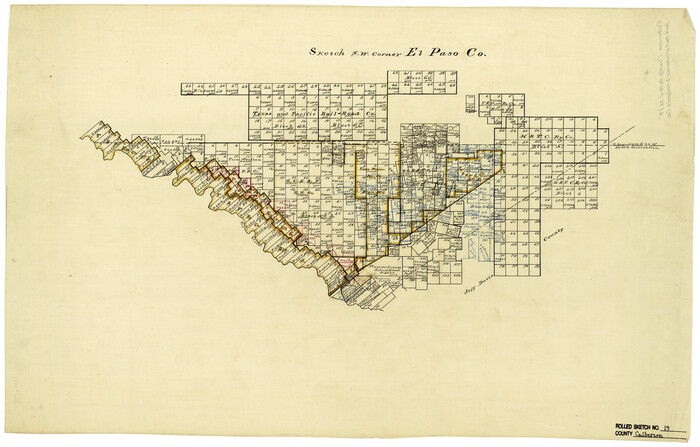
Print $20.00
- Digital $50.00
Culberson County Rolled Sketch 19
Size: 18.8 x 29.4 inches
5651
Culberson County Rolled Sketch 20
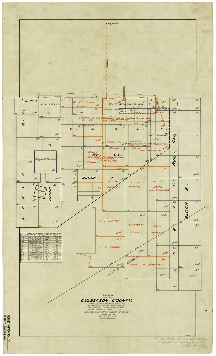
Print $20.00
- Digital $50.00
Culberson County Rolled Sketch 20
1912
Size: 30.0 x 18.2 inches
5653
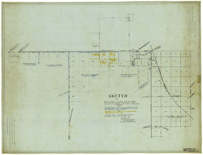
Culberson County Rolled Sketch 29

Print $20.00
- Digital $50.00
Culberson County Rolled Sketch 29
Size: 44.3 x 21.4 inches
8745
Culberson County Rolled Sketch 33

Print $20.00
- Digital $50.00
Culberson County Rolled Sketch 33
1937
Size: 36.4 x 27.9 inches
5658
Culberson County Rolled Sketch 34

Print $20.00
- Digital $50.00
Culberson County Rolled Sketch 34
1938
Size: 43.5 x 43.6 inches
8749
Culberson County Rolled Sketch 35

Print $20.00
- Digital $50.00
Culberson County Rolled Sketch 35
1934
Size: 19.1 x 10.9 inches
5659
Culberson County Rolled Sketch 36

Print $20.00
- Digital $50.00
Culberson County Rolled Sketch 36
1934
Size: 32.5 x 23.2 inches
8750
Culberson County Rolled Sketch 38
Print $20.00
- Digital $50.00
Culberson County Rolled Sketch 38
1938
Size: 29.5 x 38.8 inches
5661
Culberson County Rolled Sketch 38A

Print $20.00
- Digital $50.00
Culberson County Rolled Sketch 38A
Size: 27.2 x 30.0 inches
5662
Culberson County Rolled Sketch X1

Print $20.00
- Digital $50.00
Culberson County Rolled Sketch X1
1896
Size: 20.1 x 20.1 inches
5684
Culberson County Sketch File 18

Print $8.00
- Digital $50.00
Culberson County Sketch File 18
Size: 14.3 x 8.8 inches
20185
Culberson County Sketch File 20

Print $57.00
- Digital $50.00
Culberson County Sketch File 20
Size: 10.2 x 15.6 inches
20205
Culberson County Sketch File 21

Print $20.00
- Digital $50.00
Culberson County Sketch File 21
1937
Size: 11.2 x 8.8 inches
20224
Culberson County Sketch File 22

Print $6.00
- Digital $50.00
Culberson County Sketch File 22
1934
Size: 11.8 x 8.8 inches
20234
Culberson County Sketch File 23

Print $10.00
- Digital $50.00
Culberson County Sketch File 23
1938
Size: 14.2 x 8.6 inches
20238
Culberson County Sketch File 7

Print $8.00
- Digital $50.00
Culberson County Sketch File 7
1888
Size: 14.5 x 8.8 inches
20138
Culberson County Sketch File D

Print $32.00
- Digital $50.00
Culberson County Sketch File D
1915
Size: 7.4 x 8.8 inches
20189
Culberson County Working Sketch 2

Print $20.00
- Digital $50.00
Culberson County Working Sketch 2
Size: 27.7 x 18.7 inches
68454
Culberson County Working Sketch 3

Print $40.00
- Digital $50.00
Culberson County Working Sketch 3
Size: 50.6 x 21.1 inches
68455
Brewster County Rolled Sketch 14
Print $20.00
- Digital $50.00
Brewster County Rolled Sketch 14
1889
-
Size
31.5 x 27.3 inches
-
Map/Doc
8469
-
Creation Date
1889
Brewster County Rolled Sketch 15
Print $20.00
- Digital $50.00
Brewster County Rolled Sketch 15
1889
-
Size
32.8 x 26.4 inches
-
Map/Doc
5194
-
Creation Date
1889
Brewster County Rolled Sketch 81
Print $20.00
- Digital $50.00
Brewster County Rolled Sketch 81
-
Size
38.9 x 32.6 inches
-
Map/Doc
41812
Brewster County Rolled Sketch 81
Print $20.00
- Digital $50.00
Brewster County Rolled Sketch 81
1945
-
Size
30.8 x 33.9 inches
-
Map/Doc
8494
-
Creation Date
1945
Brewster County Working Sketch 15a
Print $40.00
- Digital $50.00
Brewster County Working Sketch 15a
1953
-
Size
22.6 x 49.1 inches
-
Map/Doc
67549
-
Creation Date
1953
Central Part of Jeff Davis Co.
Print $40.00
- Digital $50.00
Central Part of Jeff Davis Co.
1982
-
Size
55.4 x 43.9 inches
-
Map/Doc
73193
-
Creation Date
1982
Central Part of Jeff Davis Co.
Print $40.00
- Digital $50.00
Central Part of Jeff Davis Co.
1982
-
Size
54.2 x 41.6 inches
-
Map/Doc
77326
-
Creation Date
1982
Central Part of Jeff Davis Co.
Print $40.00
- Digital $50.00
Central Part of Jeff Davis Co.
1982
-
Size
56.3 x 43.9 inches
-
Map/Doc
95543
-
Creation Date
1982
Culberson County Rolled Sketch 1
Print $20.00
- Digital $50.00
Culberson County Rolled Sketch 1
1889
-
Size
28.7 x 26.4 inches
-
Map/Doc
5645
-
Creation Date
1889
Culberson County Rolled Sketch 11
Print $20.00
- Digital $50.00
Culberson County Rolled Sketch 11
1898
-
Size
25.6 x 45.9 inches
-
Map/Doc
5648
-
Creation Date
1898
Culberson County Rolled Sketch 17
Print $20.00
- Digital $50.00
Culberson County Rolled Sketch 17
1904
-
Size
22.3 x 23.8 inches
-
Map/Doc
5649
-
Creation Date
1904
Culberson County Rolled Sketch 19
Print $20.00
- Digital $50.00
Culberson County Rolled Sketch 19
-
Size
18.8 x 29.4 inches
-
Map/Doc
5651
Culberson County Rolled Sketch 20
Print $20.00
- Digital $50.00
Culberson County Rolled Sketch 20
1912
-
Size
30.0 x 18.2 inches
-
Map/Doc
5653
-
Creation Date
1912
Culberson County Rolled Sketch 29
Print $20.00
- Digital $50.00
Culberson County Rolled Sketch 29
-
Size
44.3 x 21.4 inches
-
Map/Doc
8745
Culberson County Rolled Sketch 33
Print $20.00
- Digital $50.00
Culberson County Rolled Sketch 33
1937
-
Size
36.4 x 27.9 inches
-
Map/Doc
5658
-
Creation Date
1937
Culberson County Rolled Sketch 34
Print $20.00
- Digital $50.00
Culberson County Rolled Sketch 34
1938
-
Size
43.5 x 43.6 inches
-
Map/Doc
8749
-
Creation Date
1938
Culberson County Rolled Sketch 35
Print $20.00
- Digital $50.00
Culberson County Rolled Sketch 35
1934
-
Size
19.1 x 10.9 inches
-
Map/Doc
5659
-
Creation Date
1934
Culberson County Rolled Sketch 36
Print $20.00
- Digital $50.00
Culberson County Rolled Sketch 36
1934
-
Size
32.5 x 23.2 inches
-
Map/Doc
8750
-
Creation Date
1934
Culberson County Rolled Sketch 38
Print $20.00
- Digital $50.00
Culberson County Rolled Sketch 38
1938
-
Size
29.5 x 38.8 inches
-
Map/Doc
5661
-
Creation Date
1938
Culberson County Rolled Sketch 38A
Print $20.00
- Digital $50.00
Culberson County Rolled Sketch 38A
-
Size
27.2 x 30.0 inches
-
Map/Doc
5662
Culberson County Rolled Sketch X1
Print $20.00
- Digital $50.00
Culberson County Rolled Sketch X1
1896
-
Size
20.1 x 20.1 inches
-
Map/Doc
5684
-
Creation Date
1896
Culberson County Sketch File 18
Print $8.00
- Digital $50.00
Culberson County Sketch File 18
-
Size
14.3 x 8.8 inches
-
Map/Doc
20185
Culberson County Sketch File 20
Print $57.00
- Digital $50.00
Culberson County Sketch File 20
-
Size
10.2 x 15.6 inches
-
Map/Doc
20205
Culberson County Sketch File 21
Print $20.00
- Digital $50.00
Culberson County Sketch File 21
1937
-
Size
11.2 x 8.8 inches
-
Map/Doc
20224
-
Creation Date
1937
Culberson County Sketch File 22
Print $6.00
- Digital $50.00
Culberson County Sketch File 22
1934
-
Size
11.8 x 8.8 inches
-
Map/Doc
20234
-
Creation Date
1934
Culberson County Sketch File 23
Print $10.00
- Digital $50.00
Culberson County Sketch File 23
1938
-
Size
14.2 x 8.6 inches
-
Map/Doc
20238
-
Creation Date
1938
Culberson County Sketch File 7
Print $8.00
- Digital $50.00
Culberson County Sketch File 7
1888
-
Size
14.5 x 8.8 inches
-
Map/Doc
20138
-
Creation Date
1888
Culberson County Sketch File D
Print $32.00
- Digital $50.00
Culberson County Sketch File D
1915
-
Size
7.4 x 8.8 inches
-
Map/Doc
20189
-
Creation Date
1915
Culberson County Working Sketch 2
Print $20.00
- Digital $50.00
Culberson County Working Sketch 2
-
Size
27.7 x 18.7 inches
-
Map/Doc
68454
Culberson County Working Sketch 3
Print $40.00
- Digital $50.00
Culberson County Working Sketch 3
-
Size
50.6 x 21.1 inches
-
Map/Doc
68455