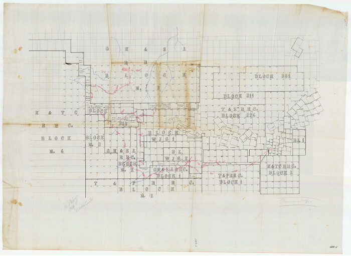
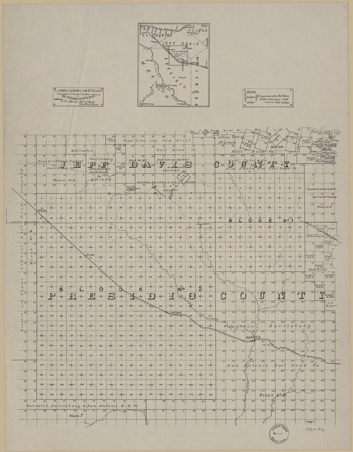
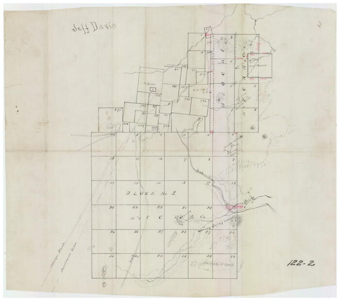
[Sketch showing Jeff Davis County, Blocks 1, 2, 3, 4, 360, 363 and JG1]
Print $20.00
- Digital $50.00
[Sketch showing Jeff Davis County, Blocks 1, 2, 3, 4, 360, 363 and JG1]
Size: 20.5 x 13.7 inches
91776
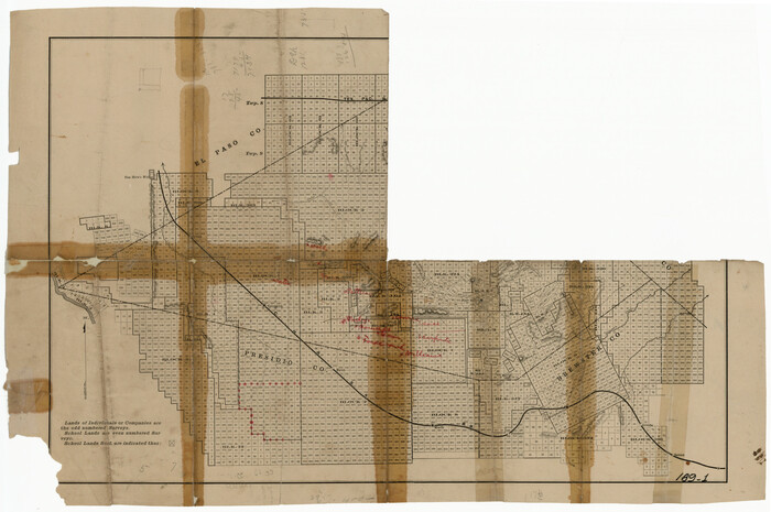
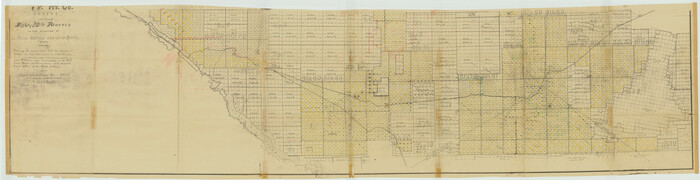
[Sketch showing Blocks C-11, C-13, C-14, C-16, C-10]
Print $40.00
- Digital $50.00
[Sketch showing Blocks C-11, C-13, C-14, C-16, C-10]
Size: 69.9 x 22.5 inches
93123
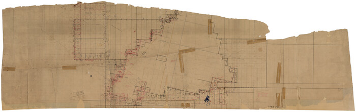
[Sketch of part of county with G.H. & S.A. Blk. 3 on North, H. & T.C. Blk. 4 on West, T. & P. Blk. 1 on South, T. & S. Blks. 224 & 301 on East]
Print $40.00
- Digital $50.00
[Sketch of part of county with G.H. & S.A. Blk. 3 on North, H. & T.C. Blk. 4 on West, T. & P. Blk. 1 on South, T. & S. Blks. 224 & 301 on East]
Size: 51.9 x 37.9 inches
89958
[Map showing T&P Lands in El Paso County]
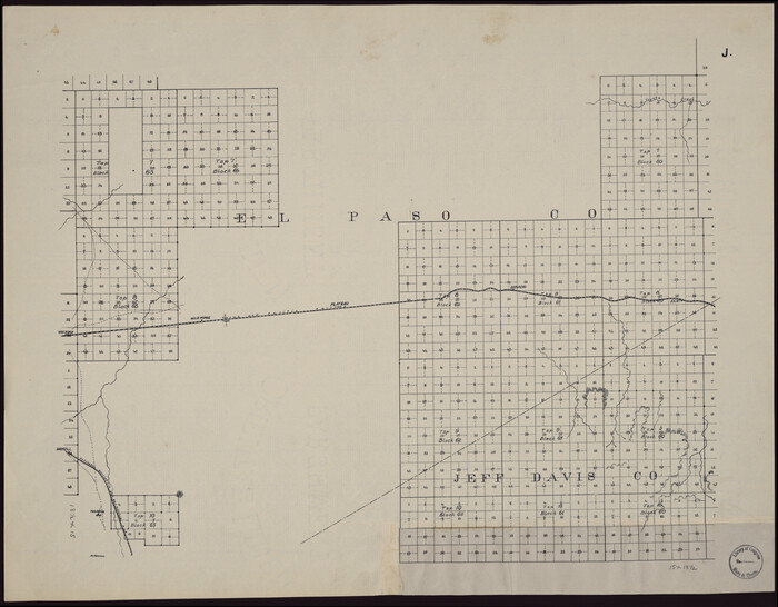
Print $20.00
[Map showing T&P Lands in El Paso County]
Size: 17.3 x 22.2 inches
88934
[Map of T&P Blocks 1 and 2 in Jeff Davis and Presidio Counties]
Print $20.00
[Map of T&P Blocks 1 and 2 in Jeff Davis and Presidio Counties]
Size: 22.2 x 17.3 inches
88959
[Index map of T. & P. Ry. Company’s 80-mile Trans-Pecos Reserve’s perpetuated corners - South Part]
Print $40.00
- Digital $50.00
[Index map of T. & P. Ry. Company’s 80-mile Trans-Pecos Reserve’s perpetuated corners - South Part]
Size: 23.1 x 90.1 inches
69766
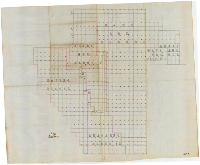
[H. & T. C. Blocks 3 and 4; G. H. & S. A Blocks 2, 4, and 12; D. & P. Block 3]
Print $20.00
- Digital $50.00
[H. & T. C. Blocks 3 and 4; G. H. & S. A Blocks 2, 4, and 12; D. & P. Block 3]
Size: 44.6 x 36.3 inches
91027
[H. & T. C. Blocks 1 and 2]
Print $3.00
- Digital $50.00
[H. & T. C. Blocks 1 and 2]
Size: 13.3 x 11.7 inches
91049
West Part of Jeff Davis Co.

Print $20.00
- Digital $50.00
West Part of Jeff Davis Co.
1977
Size: 35.0 x 45.2 inches
73195
West Part of Jeff Davis Co.

Print $20.00
- Digital $50.00
West Part of Jeff Davis Co.
1977
Size: 31.0 x 41.1 inches
77328
West Part of Jeff Davis Co.

Print $20.00
- Digital $50.00
West Part of Jeff Davis Co.
1977
Size: 36.5 x 47.5 inches
95545
Texas Coordinate File 4

Print $44.00
- Digital $50.00
Texas Coordinate File 4
Size: 11.4 x 9.1 inches
75308
Revised Sectional Map showing land surveys in counties of Loving and Reeves

Print $20.00
- Digital $50.00
Revised Sectional Map showing land surveys in counties of Loving and Reeves
Size: 18.0 x 17.7 inches
5053
Revised Sectional Map No. 5 showing land surveys in parts of counties of El Paso, Jeff Davis, Presidio and Brewster, Texas

Print $20.00
- Digital $50.00
Revised Sectional Map No. 5 showing land surveys in parts of counties of El Paso, Jeff Davis, Presidio and Brewster, Texas
Size: 19.0 x 23.7 inches
4476
Revised Sectional Map No. 3 showing land surveys in counties of Loving, Reeves and Culberson and portions of Winkler, Ward, Pecos and Jeff Davis, Texas

Print $20.00
- Digital $50.00
Revised Sectional Map No. 3 showing land surveys in counties of Loving, Reeves and Culberson and portions of Winkler, Ward, Pecos and Jeff Davis, Texas
Size: 19.0 x 24.7 inches
4478
Reeves County Working Sketch 8

Print $20.00
- Digital $50.00
Reeves County Working Sketch 8
1948
Size: 22.1 x 31.0 inches
63451
Reeves County Working Sketch 5

Print $20.00
- Digital $50.00
Reeves County Working Sketch 5
1938
Size: 38.0 x 32.4 inches
63448
Reeves County Rolled Sketch 6

Print $20.00
- Digital $50.00
Reeves County Rolled Sketch 6
Size: 22.6 x 29.0 inches
7478
Presidio County Working Sketch 99

Print $20.00
- Digital $50.00
Presidio County Working Sketch 99
1979
Size: 26.8 x 39.8 inches
71776
Presidio County Working Sketch 64

Print $40.00
- Digital $50.00
Presidio County Working Sketch 64
1958
Size: 50.2 x 37.5 inches
71741
Presidio County Working Sketch 2

Print $20.00
- Digital $50.00
Presidio County Working Sketch 2
1907
Size: 29.4 x 22.1 inches
71676
Presidio County Sketch File 85

Print $6.00
- Digital $50.00
Presidio County Sketch File 85
1950
Size: 14.3 x 8.9 inches
34745
Presidio County Sketch File 19

Print $16.00
- Digital $50.00
Presidio County Sketch File 19
1885
Size: 14.2 x 8.9 inches
34444
Presidio County Sketch File 101

Print $20.00
- Digital $50.00
Presidio County Sketch File 101
1888
Size: 21.1 x 20.3 inches
11725
Presidio County Rolled Sketch 99

Print $20.00
- Digital $50.00
Presidio County Rolled Sketch 99
Size: 38.7 x 33.6 inches
9784
Presidio County Rolled Sketch 95

Print $20.00
- Digital $50.00
Presidio County Rolled Sketch 95
1949
Size: 45.4 x 37.5 inches
9781
Presidio County Rolled Sketch 48

Print $20.00
- Digital $50.00
Presidio County Rolled Sketch 48
1908
Size: 29.9 x 35.1 inches
9775
Presidio County Rolled Sketch 47

Print $20.00
- Digital $50.00
Presidio County Rolled Sketch 47
1908
Size: 30.8 x 32.2 inches
7343
Presidio County Rolled Sketch 46

Print $20.00
- Digital $50.00
Presidio County Rolled Sketch 46
1908
Size: 19.0 x 15.5 inches
7342
Presidio County Rolled Sketch 35

Print $20.00
- Digital $50.00
Presidio County Rolled Sketch 35
Size: 44.7 x 32.1 inches
9774
[Sketch showing Jeff Davis County, Blocks 1, 2, 3, 4, 360, 363 and JG1]
Print $20.00
- Digital $50.00
[Sketch showing Jeff Davis County, Blocks 1, 2, 3, 4, 360, 363 and JG1]
-
Size
20.5 x 13.7 inches
-
Map/Doc
91776
[Sketch showing Blocks C-11, C-13, C-14, C-16, C-10]
Print $40.00
- Digital $50.00
[Sketch showing Blocks C-11, C-13, C-14, C-16, C-10]
-
Size
69.9 x 22.5 inches
-
Map/Doc
93123
[Sketch of part of county with G.H. & S.A. Blk. 3 on North, H. & T.C. Blk. 4 on West, T. & P. Blk. 1 on South, T. & S. Blks. 224 & 301 on East]
Print $40.00
- Digital $50.00
[Sketch of part of county with G.H. & S.A. Blk. 3 on North, H. & T.C. Blk. 4 on West, T. & P. Blk. 1 on South, T. & S. Blks. 224 & 301 on East]
-
Size
51.9 x 37.9 inches
-
Map/Doc
89958
[Map showing T&P Lands in El Paso County]
Print $20.00
[Map showing T&P Lands in El Paso County]
-
Size
17.3 x 22.2 inches
-
Map/Doc
88934
[Map of T&P Blocks 1 and 2 in Jeff Davis and Presidio Counties]
Print $20.00
[Map of T&P Blocks 1 and 2 in Jeff Davis and Presidio Counties]
-
Size
22.2 x 17.3 inches
-
Map/Doc
88959
[Index map of T. & P. Ry. Company’s 80-mile Trans-Pecos Reserve’s perpetuated corners - South Part]
Print $40.00
- Digital $50.00
[Index map of T. & P. Ry. Company’s 80-mile Trans-Pecos Reserve’s perpetuated corners - South Part]
-
Size
23.1 x 90.1 inches
-
Map/Doc
69766
[H. & T. C. Blocks 3 and 4; G. H. & S. A Blocks 2, 4, and 12; D. & P. Block 3]
Print $20.00
- Digital $50.00
[H. & T. C. Blocks 3 and 4; G. H. & S. A Blocks 2, 4, and 12; D. & P. Block 3]
-
Size
44.6 x 36.3 inches
-
Map/Doc
91027
[H. & T. C. Blocks 1 and 2]
Print $3.00
- Digital $50.00
[H. & T. C. Blocks 1 and 2]
-
Size
13.3 x 11.7 inches
-
Map/Doc
91049
West Part of Jeff Davis Co.
Print $20.00
- Digital $50.00
West Part of Jeff Davis Co.
1977
-
Size
35.0 x 45.2 inches
-
Map/Doc
73195
-
Creation Date
1977
West Part of Jeff Davis Co.
Print $20.00
- Digital $50.00
West Part of Jeff Davis Co.
1977
-
Size
31.0 x 41.1 inches
-
Map/Doc
77328
-
Creation Date
1977
West Part of Jeff Davis Co.
Print $20.00
- Digital $50.00
West Part of Jeff Davis Co.
1977
-
Size
36.5 x 47.5 inches
-
Map/Doc
95545
-
Creation Date
1977
Texas Coordinate File 4
Print $44.00
- Digital $50.00
Texas Coordinate File 4
-
Size
11.4 x 9.1 inches
-
Map/Doc
75308
Revised Sectional Map showing land surveys in counties of Loving and Reeves
Print $20.00
- Digital $50.00
Revised Sectional Map showing land surveys in counties of Loving and Reeves
-
Size
18.0 x 17.7 inches
-
Map/Doc
5053
Revised Sectional Map No. 5 showing land surveys in parts of counties of El Paso, Jeff Davis, Presidio and Brewster, Texas
Print $20.00
- Digital $50.00
Revised Sectional Map No. 5 showing land surveys in parts of counties of El Paso, Jeff Davis, Presidio and Brewster, Texas
-
Size
19.0 x 23.7 inches
-
Map/Doc
4476
Revised Sectional Map No. 3 showing land surveys in counties of Loving, Reeves and Culberson and portions of Winkler, Ward, Pecos and Jeff Davis, Texas
Print $20.00
- Digital $50.00
Revised Sectional Map No. 3 showing land surveys in counties of Loving, Reeves and Culberson and portions of Winkler, Ward, Pecos and Jeff Davis, Texas
-
Size
19.0 x 24.7 inches
-
Map/Doc
4478
Reeves County Working Sketch 8
Print $20.00
- Digital $50.00
Reeves County Working Sketch 8
1948
-
Size
22.1 x 31.0 inches
-
Map/Doc
63451
-
Creation Date
1948
Reeves County Working Sketch 5
Print $20.00
- Digital $50.00
Reeves County Working Sketch 5
1938
-
Size
38.0 x 32.4 inches
-
Map/Doc
63448
-
Creation Date
1938
Reeves County Rolled Sketch 6
Print $20.00
- Digital $50.00
Reeves County Rolled Sketch 6
-
Size
22.6 x 29.0 inches
-
Map/Doc
7478
Presidio County Working Sketch 99
Print $20.00
- Digital $50.00
Presidio County Working Sketch 99
1979
-
Size
26.8 x 39.8 inches
-
Map/Doc
71776
-
Creation Date
1979
Presidio County Working Sketch 64
Print $40.00
- Digital $50.00
Presidio County Working Sketch 64
1958
-
Size
50.2 x 37.5 inches
-
Map/Doc
71741
-
Creation Date
1958
Presidio County Working Sketch 2
Print $20.00
- Digital $50.00
Presidio County Working Sketch 2
1907
-
Size
29.4 x 22.1 inches
-
Map/Doc
71676
-
Creation Date
1907
Presidio County Sketch File 85
Print $6.00
- Digital $50.00
Presidio County Sketch File 85
1950
-
Size
14.3 x 8.9 inches
-
Map/Doc
34745
-
Creation Date
1950
Presidio County Sketch File 19
Print $16.00
- Digital $50.00
Presidio County Sketch File 19
1885
-
Size
14.2 x 8.9 inches
-
Map/Doc
34444
-
Creation Date
1885
Presidio County Sketch File 101
Print $20.00
- Digital $50.00
Presidio County Sketch File 101
1888
-
Size
21.1 x 20.3 inches
-
Map/Doc
11725
-
Creation Date
1888
Presidio County Rolled Sketch 99
Print $20.00
- Digital $50.00
Presidio County Rolled Sketch 99
-
Size
38.7 x 33.6 inches
-
Map/Doc
9784
Presidio County Rolled Sketch 95
Print $20.00
- Digital $50.00
Presidio County Rolled Sketch 95
1949
-
Size
45.4 x 37.5 inches
-
Map/Doc
9781
-
Creation Date
1949
Presidio County Rolled Sketch 48
Print $20.00
- Digital $50.00
Presidio County Rolled Sketch 48
1908
-
Size
29.9 x 35.1 inches
-
Map/Doc
9775
-
Creation Date
1908
Presidio County Rolled Sketch 47
Print $20.00
- Digital $50.00
Presidio County Rolled Sketch 47
1908
-
Size
30.8 x 32.2 inches
-
Map/Doc
7343
-
Creation Date
1908
Presidio County Rolled Sketch 46
Print $20.00
- Digital $50.00
Presidio County Rolled Sketch 46
1908
-
Size
19.0 x 15.5 inches
-
Map/Doc
7342
-
Creation Date
1908
Presidio County Rolled Sketch 35
Print $20.00
- Digital $50.00
Presidio County Rolled Sketch 35
-
Size
44.7 x 32.1 inches
-
Map/Doc
9774