Atlas T - Titles to Frontier Settlers issued by the Commissioner Carlos S. Taylor

Atlas T - Titles to Frontier Settlers issued by the Commissioner Carlos S. Taylor
1834
94536
Buenaventura Reyes Grants

Print $20.00
- Digital $50.00
Buenaventura Reyes Grants
1896
Size: 14.9 x 13.5 inches
2057
Calcasieu Pass to Sabine Pass

Print $20.00
- Digital $50.00
Calcasieu Pass to Sabine Pass
1925
Size: 44.1 x 36.0 inches
69804
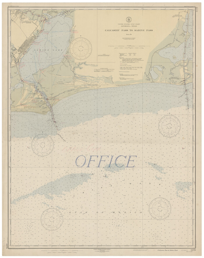
Calcasieu Pass to Sabine Pass

Print $20.00
- Digital $50.00
Calcasieu Pass to Sabine Pass
1943
Size: 44.5 x 35.1 inches
69805
Calcasieu Pass to Sabine Pass

Print $20.00
- Digital $50.00
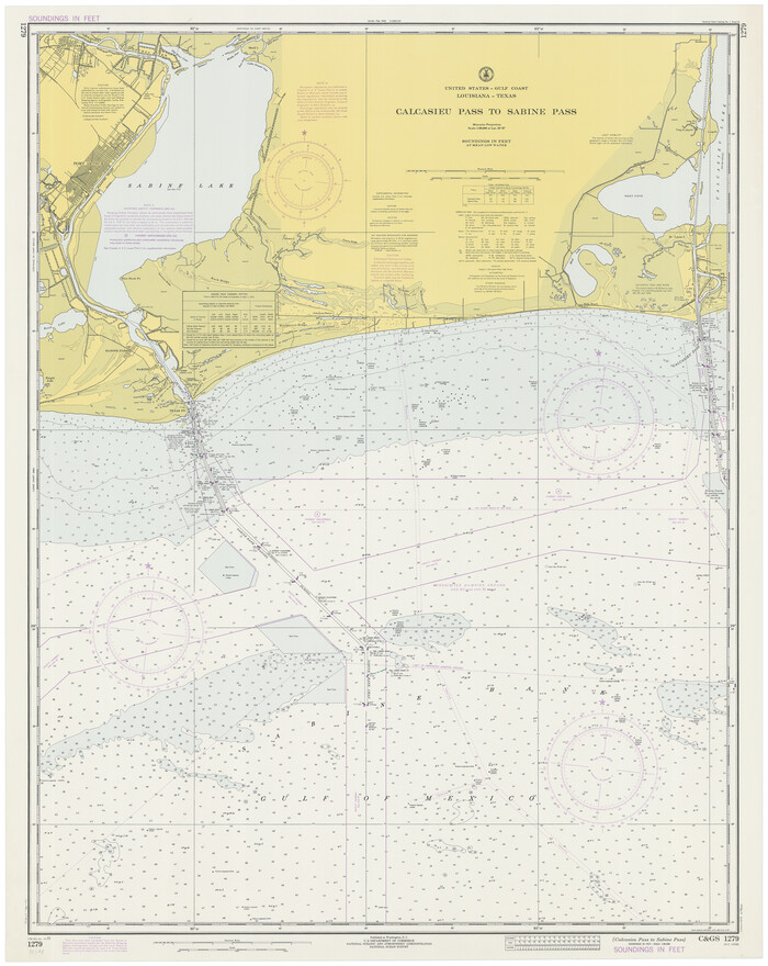
Calcasieu Pass to Sabine Pass
1946
Size: 44.7 x 35.7 inches
69806
Calcasieu Pass to Sabine Pass
Print $20.00
- Digital $50.00
Calcasieu Pass to Sabine Pass
1946
Size: 45.0 x 35.7 inches
69807
Calcasieu Pass to Sabine Pass

Print $20.00
- Digital $50.00
Calcasieu Pass to Sabine Pass
1950
Size: 44.8 x 35.4 inches
69808
Calcasieu Pass to Sabine Pass

Print $20.00
- Digital $50.00
Calcasieu Pass to Sabine Pass
1961
Size: 44.6 x 35.7 inches
69809
Calcasieu Pass to Sabine Pass

Print $20.00
- Digital $50.00
Calcasieu Pass to Sabine Pass
1966
Size: 44.9 x 35.5 inches
69810
Calcasieu Pass to Sabine Pass

Print $20.00
- Digital $50.00
Calcasieu Pass to Sabine Pass
1972
Size: 44.9 x 35.8 inches
69811
Calcasieu Pass to Sabine Pass
Print $20.00
- Digital $50.00
Calcasieu Pass to Sabine Pass
1973
Size: 44.8 x 35.6 inches
69812
Calcasieu Pass to Sabine Pass

Print $20.00
- Digital $50.00
Calcasieu Pass to Sabine Pass
1976
Size: 44.6 x 35.3 inches
69813
Calcasieu Pass to Sabine Pass

Print $20.00
- Digital $50.00
Calcasieu Pass to Sabine Pass
1982
Size: 45.0 x 36.6 inches
69814
Calcasieu Pass to Sabine Pass

Print $20.00
- Digital $50.00
Calcasieu Pass to Sabine Pass
1992
Size: 44.5 x 35.8 inches
69815
Chambers County Boundary File 4

Print $34.00
- Digital $50.00
Chambers County Boundary File 4
1909
Size: 9.1 x 3.9 inches
51259
Chambers County Rolled Sketch 19

Print $20.00
- Digital $50.00
Chambers County Rolled Sketch 19
Size: 39.8 x 44.4 inches
8588
Chambers County Rolled Sketch CL

Print $40.00
- Digital $50.00
Chambers County Rolled Sketch CL
1909
Size: 56.2 x 21.0 inches
8610
Chambers County Sketch File 19

Print $26.00
- Digital $50.00
Chambers County Sketch File 19
Size: 14.1 x 8.6 inches
17578
Chambers County Sketch File 24

Print $20.00
- Digital $50.00
Chambers County Sketch File 24
1909
Size: 34.1 x 14.5 inches
11065
Chambers County Sketch File 29

Print $20.00
- Digital $50.00
Chambers County Sketch File 29
Size: 29.0 x 34.5 inches
10332
City and Harbor of Port Arthur Texas, Bird's Eye View Looking South to the Gulf of Mexico

Print $20.00
City and Harbor of Port Arthur Texas, Bird's Eye View Looking South to the Gulf of Mexico
1912
Size: 17.4 x 39.9 inches
93483
Clarke and Courts' Map of Jefferson County and Beaumont and Sour Lake Oil Fields

Print $20.00
Clarke and Courts' Map of Jefferson County and Beaumont and Sour Lake Oil Fields
1901
Size: 28.2 x 24.3 inches
79289
Coast Chart No. 202 - Calcasieu Pass to Sabine Light, Louisiana

Print $20.00
- Digital $50.00
Coast Chart No. 202 - Calcasieu Pass to Sabine Light, Louisiana
1905
Size: 40.7 x 34.4 inches
69803
Coast Chart No. 203 - Coast of Texas from Sabine Pass Westward to High Island

Print $20.00
- Digital $50.00
Coast Chart No. 203 - Coast of Texas from Sabine Pass Westward to High Island
1901
Size: 40.4 x 34.3 inches
69843
Coast of Texas from head of East Bay Galveston Harbor to Sabine Pass

Print $40.00
- Digital $50.00
Coast of Texas from head of East Bay Galveston Harbor to Sabine Pass
1882
Size: 32.6 x 54.1 inches
69838
Coast of Texas from head of East Bay Galveston Harbor to Sabine Pass

Print $40.00
- Digital $50.00
Coast of Texas from head of East Bay Galveston Harbor to Sabine Pass
1882
Size: 32.2 x 54.1 inches
69839
Coast of Texas from head of East Bay Galveston Harbor to Sabine Pass

Print $40.00
- Digital $50.00
Coast of Texas from head of East Bay Galveston Harbor to Sabine Pass
1882
Size: 32.3 x 53.9 inches
69840
English Field Notes of the Spanish Archives - Book 4 & W

English Field Notes of the Spanish Archives - Book 4 & W
1836
96530
English Field Notes of the Spanish Archives - Books DB3 & WR

English Field Notes of the Spanish Archives - Books DB3 & WR
1835
96548
Atlas T - Titles to Frontier Settlers issued by the Commissioner Carlos S. Taylor
Atlas T - Titles to Frontier Settlers issued by the Commissioner Carlos S. Taylor
1834
-
Map/Doc
94536
-
Creation Date
1834
Beaumont, Texas

Print $20.00
- Digital $50.00
Beaumont, Texas
1930
-
Size
10.3 x 32.7 inches
-
Map/Doc
96428
-
Creation Date
1930
Buenaventura Reyes Grants
Print $20.00
- Digital $50.00
Buenaventura Reyes Grants
1896
-
Size
14.9 x 13.5 inches
-
Map/Doc
2057
-
Creation Date
1896
Calcasieu Pass to Sabine Pass
Print $20.00
- Digital $50.00
Calcasieu Pass to Sabine Pass
1925
-
Size
44.1 x 36.0 inches
-
Map/Doc
69804
-
Creation Date
1925
Calcasieu Pass to Sabine Pass
Print $20.00
- Digital $50.00
Calcasieu Pass to Sabine Pass
1943
-
Size
44.5 x 35.1 inches
-
Map/Doc
69805
-
Creation Date
1943
Calcasieu Pass to Sabine Pass
Print $20.00
- Digital $50.00
Calcasieu Pass to Sabine Pass
1946
-
Size
44.7 x 35.7 inches
-
Map/Doc
69806
-
Creation Date
1946
Calcasieu Pass to Sabine Pass
Print $20.00
- Digital $50.00
Calcasieu Pass to Sabine Pass
1946
-
Size
45.0 x 35.7 inches
-
Map/Doc
69807
-
Creation Date
1946
Calcasieu Pass to Sabine Pass
Print $20.00
- Digital $50.00
Calcasieu Pass to Sabine Pass
1950
-
Size
44.8 x 35.4 inches
-
Map/Doc
69808
-
Creation Date
1950
Calcasieu Pass to Sabine Pass
Print $20.00
- Digital $50.00
Calcasieu Pass to Sabine Pass
1961
-
Size
44.6 x 35.7 inches
-
Map/Doc
69809
-
Creation Date
1961
Calcasieu Pass to Sabine Pass
Print $20.00
- Digital $50.00
Calcasieu Pass to Sabine Pass
1966
-
Size
44.9 x 35.5 inches
-
Map/Doc
69810
-
Creation Date
1966
Calcasieu Pass to Sabine Pass
Print $20.00
- Digital $50.00
Calcasieu Pass to Sabine Pass
1972
-
Size
44.9 x 35.8 inches
-
Map/Doc
69811
-
Creation Date
1972
Calcasieu Pass to Sabine Pass
Print $20.00
- Digital $50.00
Calcasieu Pass to Sabine Pass
1973
-
Size
44.8 x 35.6 inches
-
Map/Doc
69812
-
Creation Date
1973
Calcasieu Pass to Sabine Pass
Print $20.00
- Digital $50.00
Calcasieu Pass to Sabine Pass
1976
-
Size
44.6 x 35.3 inches
-
Map/Doc
69813
-
Creation Date
1976
Calcasieu Pass to Sabine Pass
Print $20.00
- Digital $50.00
Calcasieu Pass to Sabine Pass
1982
-
Size
45.0 x 36.6 inches
-
Map/Doc
69814
-
Creation Date
1982
Calcasieu Pass to Sabine Pass
Print $20.00
- Digital $50.00
Calcasieu Pass to Sabine Pass
1992
-
Size
44.5 x 35.8 inches
-
Map/Doc
69815
-
Creation Date
1992
Chambers County Boundary File 4
Print $34.00
- Digital $50.00
Chambers County Boundary File 4
1909
-
Size
9.1 x 3.9 inches
-
Map/Doc
51259
-
Creation Date
1909
Chambers County Rolled Sketch 19
Print $20.00
- Digital $50.00
Chambers County Rolled Sketch 19
-
Size
39.8 x 44.4 inches
-
Map/Doc
8588
Chambers County Rolled Sketch CL
Print $40.00
- Digital $50.00
Chambers County Rolled Sketch CL
1909
-
Size
56.2 x 21.0 inches
-
Map/Doc
8610
-
Creation Date
1909
Chambers County Sketch File 19
Print $26.00
- Digital $50.00
Chambers County Sketch File 19
-
Size
14.1 x 8.6 inches
-
Map/Doc
17578
Chambers County Sketch File 24
Print $20.00
- Digital $50.00
Chambers County Sketch File 24
1909
-
Size
34.1 x 14.5 inches
-
Map/Doc
11065
-
Creation Date
1909
Chambers County Sketch File 29
Print $20.00
- Digital $50.00
Chambers County Sketch File 29
-
Size
29.0 x 34.5 inches
-
Map/Doc
10332
City and Harbor of Port Arthur Texas, Bird's Eye View Looking South to the Gulf of Mexico
Print $20.00
City and Harbor of Port Arthur Texas, Bird's Eye View Looking South to the Gulf of Mexico
1912
-
Size
17.4 x 39.9 inches
-
Map/Doc
93483
-
Creation Date
1912
Clarke and Courts' Map of Jefferson County and Beaumont and Sour Lake Oil Fields
Print $20.00
Clarke and Courts' Map of Jefferson County and Beaumont and Sour Lake Oil Fields
1901
-
Size
28.2 x 24.3 inches
-
Map/Doc
79289
-
Creation Date
1901
Coast Chart No. 202 - Calcasieu Pass to Sabine Light, Louisiana
Print $20.00
- Digital $50.00
Coast Chart No. 202 - Calcasieu Pass to Sabine Light, Louisiana
1905
-
Size
40.7 x 34.4 inches
-
Map/Doc
69803
-
Creation Date
1905
Coast Chart No. 203 - Coast of Texas from Sabine Pass Westward to High Island
Print $20.00
- Digital $50.00
Coast Chart No. 203 - Coast of Texas from Sabine Pass Westward to High Island
1901
-
Size
40.4 x 34.3 inches
-
Map/Doc
69843
-
Creation Date
1901
Coast of Texas from head of East Bay Galveston Harbor to Sabine Pass
Print $40.00
- Digital $50.00
Coast of Texas from head of East Bay Galveston Harbor to Sabine Pass
1882
-
Size
32.6 x 54.1 inches
-
Map/Doc
69838
-
Creation Date
1882
Coast of Texas from head of East Bay Galveston Harbor to Sabine Pass
Print $40.00
- Digital $50.00
Coast of Texas from head of East Bay Galveston Harbor to Sabine Pass
1882
-
Size
32.2 x 54.1 inches
-
Map/Doc
69839
-
Creation Date
1882
Coast of Texas from head of East Bay Galveston Harbor to Sabine Pass
Print $40.00
- Digital $50.00
Coast of Texas from head of East Bay Galveston Harbor to Sabine Pass
1882
-
Size
32.3 x 53.9 inches
-
Map/Doc
69840
-
Creation Date
1882
English Field Notes of the Spanish Archives - Book 4 & W
English Field Notes of the Spanish Archives - Book 4 & W
1836
-
Map/Doc
96530
-
Creation Date
1836
English Field Notes of the Spanish Archives - Books DB3 & WR
English Field Notes of the Spanish Archives - Books DB3 & WR
1835
-
Map/Doc
96548
-
Creation Date
1835