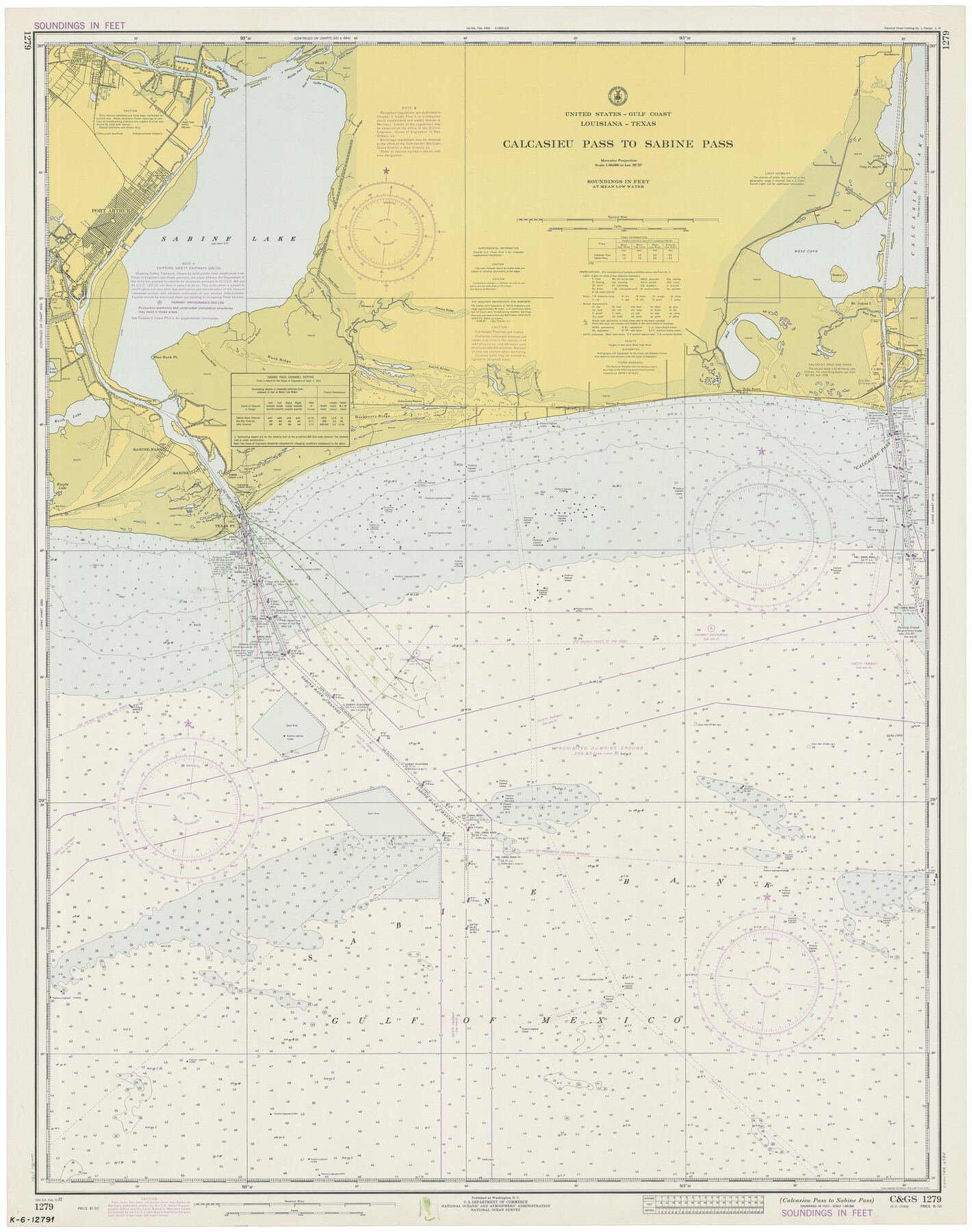
Calcasieu Pass to Sabine Pass
K-6-1279a
-
Map/Doc
69811
-
Collection
General Map Collection
-
Object Dates
2/5/1972 (Creation Date)
-
Counties
Jefferson Orange
-
Subjects
Nautical Charts
-
Height x Width
44.9 x 35.8 inches
114.1 x 90.9 cm
Part of: General Map Collection
Guadalupe County Working Sketch 6

Print $20.00
- Digital $50.00
Guadalupe County Working Sketch 6
1948
Size 24.0 x 19.7 inches
Map/Doc 63315
Fisher County Working Sketch 20

Print $20.00
- Digital $50.00
Fisher County Working Sketch 20
1993
Size 38.1 x 26.6 inches
Map/Doc 69154
Flight Mission No. BRA-6M, Frame 78, Jefferson County

Print $20.00
- Digital $50.00
Flight Mission No. BRA-6M, Frame 78, Jefferson County
1953
Size 18.7 x 22.4 inches
Map/Doc 85422

[Surveys near Brushy Creek]
![361, [Surveys near Brushy Creek], General Map Collection](https://historictexasmaps.com/wmedia_w700/maps/361.tif.jpg)
Print $2.00
- Digital $50.00
[Surveys near Brushy Creek]
1846
Size 9.1 x 7.7 inches
Map/Doc 361
Trinity County Working Sketch 26

Print $20.00
- Digital $50.00
Trinity County Working Sketch 26
2010
Size 21.0 x 34.1 inches
Map/Doc 89601
Carson County Sketch File 8

Print $6.00
- Digital $50.00
Carson County Sketch File 8
1931
Size 11.2 x 8.6 inches
Map/Doc 17389
La Salle County Rolled Sketch 28

Print $90.00
- Digital $50.00
La Salle County Rolled Sketch 28
1956
Size 51.1 x 49.1 inches
Map/Doc 9561
Cherokee County Sketch File 30

Print $17.00
- Digital $50.00
Cherokee County Sketch File 30
1934
Size 10.3 x 9.4 inches
Map/Doc 18176
Jim Hogg County Rolled Sketch 2

Print $20.00
- Digital $50.00
Jim Hogg County Rolled Sketch 2
Size 27.9 x 32.7 inches
Map/Doc 6438

St. Louis, Brownsville & Mexico Railway Location map from Mile 40 to Mile 60

Print $40.00
- Digital $50.00
St. Louis, Brownsville & Mexico Railway Location map from Mile 40 to Mile 60
1905
Size 19.6 x 74.9 inches
Map/Doc 64079
You may also like
Harris County Sketch File 5

Print $20.00
- Digital $50.00
Harris County Sketch File 5
1858
Size 22.0 x 15.0 inches
Map/Doc 11648
Flight Mission No. BRA-16M, Frame 72, Jefferson County

Print $20.00
- Digital $50.00
Flight Mission No. BRA-16M, Frame 72, Jefferson County
1953
Size 18.5 x 22.4 inches
Map/Doc 85689
Hudspeth County Rolled Sketch 60

Print $20.00
- Digital $50.00
Hudspeth County Rolled Sketch 60
1982
Size 43.4 x 44.4 inches
Map/Doc 9225
Kerr County Working Sketch 13

Print $20.00
- Digital $50.00
Kerr County Working Sketch 13
1951
Size 24.3 x 22.3 inches
Map/Doc 70044
Childress County Boundary File 2

Print $66.00
- Digital $50.00
Childress County Boundary File 2
Size 7.3 x 3.9 inches
Map/Doc 51306
Bird's Eye View of Schulenburg, Fayette County, Texas

Print $20.00
Bird's Eye View of Schulenburg, Fayette County, Texas
1881
Size 18.6 x 31.0 inches
Map/Doc 89206
Cameron County Rolled Sketch 34

Print $20.00
- Digital $50.00
Cameron County Rolled Sketch 34
2000
Size 24.2 x 35.2 inches
Map/Doc 5397
Calhoun County Rolled Sketch 20

Print $20.00
- Digital $50.00
Calhoun County Rolled Sketch 20
1959
Size 36.9 x 20.7 inches
Map/Doc 5372
Crockett County Sketch File 91

Print $76.00
- Digital $50.00
Crockett County Sketch File 91
1968
Size 11.3 x 8.8 inches
Map/Doc 19918
Edwards County

Print $40.00
- Digital $50.00
Edwards County
1900
Size 47.7 x 59.8 inches
Map/Doc 82082
Flight Mission No. BRA-7M, Frame 83, Jefferson County

Print $20.00
- Digital $50.00
Flight Mission No. BRA-7M, Frame 83, Jefferson County
1953
Size 16.1 x 16.1 inches
Map/Doc 85505
Appletons' Railway Map of the Southern States, to accompany Appletons' Hand-book of American Travel, Southern Tour

Print $20.00
- Digital $50.00
Appletons' Railway Map of the Southern States, to accompany Appletons' Hand-book of American Travel, Southern Tour
1887
Size 15.6 x 24.3 inches
Map/Doc 95904