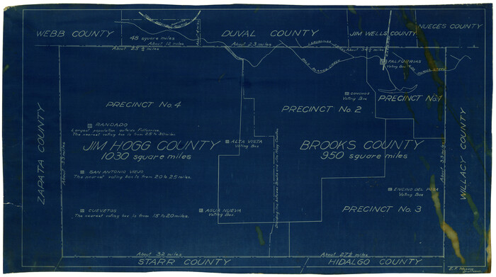
[Sketch showing voting precincts in Jim Hogg and Brooks Counties]
Print $20.00
- Digital $50.00
[Sketch showing voting precincts in Jim Hogg and Brooks Counties]
Size: 10.1 x 18.2 inches
4497
Starr County Sketch File 14

Print $40.00
- Digital $50.00
Starr County Sketch File 14
Size: 23.8 x 46.0 inches
4626
Jim Hogg County Boundary File 1

Print $16.00
- Digital $50.00
Jim Hogg County Boundary File 1
Size: 11.4 x 8.8 inches
55519
Jim Hogg County Boundary File 2

Print $4.00
- Digital $50.00
Jim Hogg County Boundary File 2
Size: 10.6 x 8.7 inches
55527
Jim Hogg County Boundary File 3

Print $4.00
- Digital $50.00
Jim Hogg County Boundary File 3
Size: 8.8 x 11.2 inches
55529
Skeleton Map of Nueces County

Print $20.00
- Digital $50.00
Skeleton Map of Nueces County
Size: 35.5 x 39.4 inches
592
Jim Hogg County Rolled Sketch 2

Print $20.00
- Digital $50.00
Jim Hogg County Rolled Sketch 2
Size: 27.9 x 32.7 inches
6438
Jim Hogg County Rolled Sketch 4

Print $20.00
- Digital $50.00
Jim Hogg County Rolled Sketch 4
Size: 17.0 x 30.5 inches
6440
Jim Hogg County Working Sketch 10

Print $20.00
- Digital $50.00
Jim Hogg County Working Sketch 10
Size: 18.8 x 15.6 inches
66596
Starr County Sketch File 5

Print $40.00
- Digital $50.00
Starr County Sketch File 5
Size: 31.4 x 40.7 inches
82571
Duval County Sketch File 5

Print $20.00
- Digital $50.00
Duval County Sketch File 5
1860
Size: 20.8 x 29.6 inches
11381
Zapata County Sketch File 1

Print $20.00
- Digital $50.00
Zapata County Sketch File 1
1875
Size: 30.5 x 21.4 inches
12717
Starr County Sketch File 17

Print $24.00
- Digital $50.00
Starr County Sketch File 17
1880
Size: 12.8 x 8.2 inches
36874
Starr County Sketch File 18

Print $20.00
- Digital $50.00
Starr County Sketch File 18
1880
Size: 38.2 x 25.1 inches
10606
Duval County Sketch File 26

Print $4.00
- Digital $50.00
Duval County Sketch File 26
1882
Size: 13.0 x 9.0 inches
21332
Starr County Sketch File 13

Print $20.00
- Digital $50.00
Starr County Sketch File 13
1886
Size: 12.4 x 19.5 inches
12329
Zapata County Sketch File 5

Print $20.00
- Digital $50.00
Zapata County Sketch File 5
1886
Size: 15.4 x 16.9 inches
12719
Starr County Sketch File 12

Print $20.00
- Digital $50.00
Starr County Sketch File 12
1886
Size: 16.2 x 23.7 inches
12328
Zapata County Sketch File 4a

Print $4.00
- Digital $50.00
Zapata County Sketch File 4a
1891
Size: 14.2 x 8.8 inches
40908
Zapata County Sketch File 4

Print $22.00
- Digital $50.00
Zapata County Sketch File 4
1892
Size: 14.5 x 17.5 inches
40906
Starr County Sketch File D

Print $8.00
- Digital $50.00
Starr County Sketch File D
1892
Size: 14.2 x 8.7 inches
36915
Starr County Sketch File 20a

Print $12.00
- Digital $50.00
Starr County Sketch File 20a
1892
Size: 14.3 x 8.8 inches
36883
Duval County Rolled Sketch OS

Print $20.00
- Digital $50.00
Duval County Rolled Sketch OS
1903
Size: 36.0 x 31.9 inches
8803
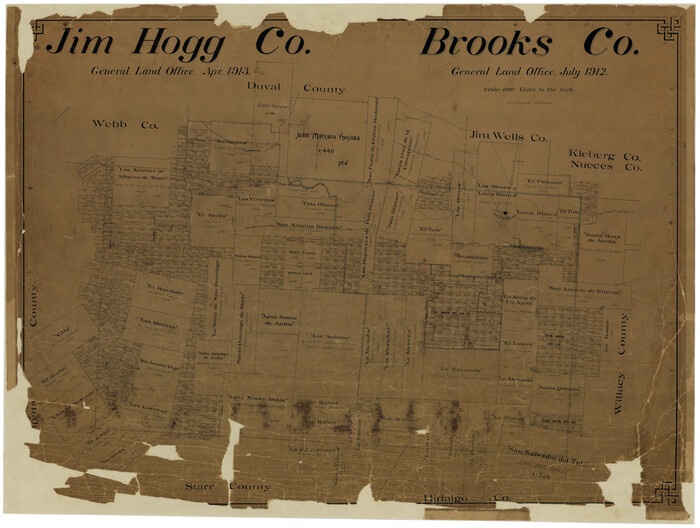
Jim Hogg Co. / Brooks Co.

Print $20.00
- Digital $50.00
Jim Hogg Co. / Brooks Co.
1912
Size: 33.0 x 43.6 inches
4894
Jim Hogg County Rolled Sketch 3

Print $20.00
- Digital $50.00
Jim Hogg County Rolled Sketch 3
1912
Size: 28.2 x 20.2 inches
6439
Jim Hogg County Rolled Sketch 13

Print $65.00
- Digital $50.00
Jim Hogg County Rolled Sketch 13
1913
Size: 21.9 x 28.1 inches
6444
Jim Hogg Co. [and] Brooks Co.
Print $20.00
- Digital $50.00
Jim Hogg Co. [and] Brooks Co.
1913
Size: 31.8 x 41.8 inches
4756
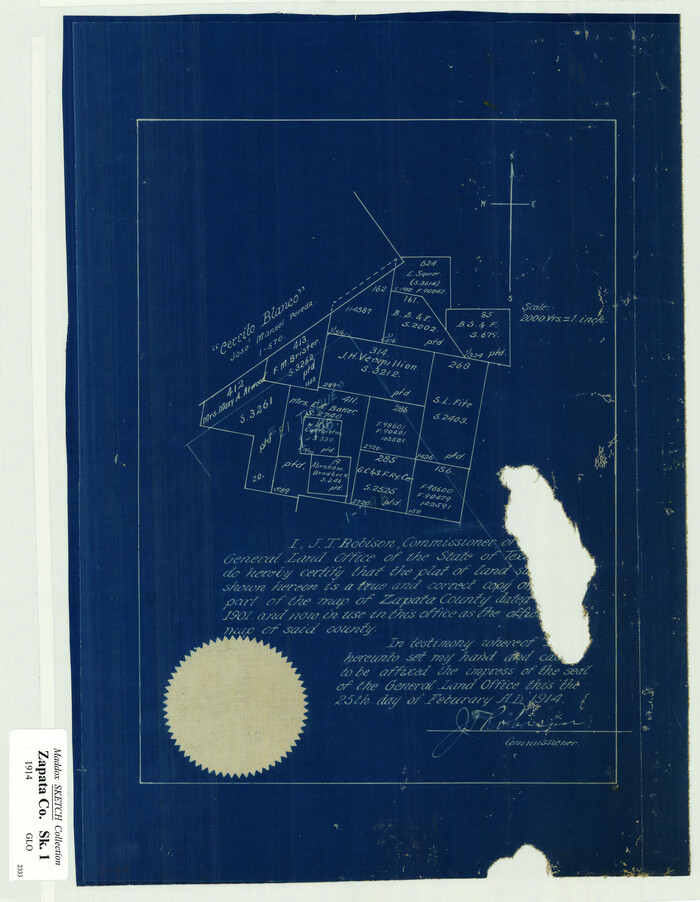
[Surveying Sketch of J.H. Vermillion, S.L. Fite, et al in Zapata County]
Print $20.00
- Digital $50.00
[Surveying Sketch of J.H. Vermillion, S.L. Fite, et al in Zapata County]
1914
Size: 15.6 x 12.1 inches
698
Oil Development and Structural Map showing Schott, Mirando and other oil fields of the Laredo District with present and proposed development.

Print $20.00
- Digital $50.00
Oil Development and Structural Map showing Schott, Mirando and other oil fields of the Laredo District with present and proposed development.
1920
Size: 11.3 x 8.9 inches
94107
[Sketch showing voting precincts in Jim Hogg and Brooks Counties]
Print $20.00
- Digital $50.00
[Sketch showing voting precincts in Jim Hogg and Brooks Counties]
-
Size
10.1 x 18.2 inches
-
Map/Doc
4497
Starr County Sketch File 14
Print $40.00
- Digital $50.00
Starr County Sketch File 14
-
Size
23.8 x 46.0 inches
-
Map/Doc
4626
Jim Hogg County Boundary File 1
Print $16.00
- Digital $50.00
Jim Hogg County Boundary File 1
-
Size
11.4 x 8.8 inches
-
Map/Doc
55519
Jim Hogg County Boundary File 2
Print $4.00
- Digital $50.00
Jim Hogg County Boundary File 2
-
Size
10.6 x 8.7 inches
-
Map/Doc
55527
Jim Hogg County Boundary File 3
Print $4.00
- Digital $50.00
Jim Hogg County Boundary File 3
-
Size
8.8 x 11.2 inches
-
Map/Doc
55529
Skeleton Map of Nueces County
Print $20.00
- Digital $50.00
Skeleton Map of Nueces County
-
Size
35.5 x 39.4 inches
-
Map/Doc
592
Jim Hogg County Rolled Sketch 2
Print $20.00
- Digital $50.00
Jim Hogg County Rolled Sketch 2
-
Size
27.9 x 32.7 inches
-
Map/Doc
6438
Jim Hogg County Rolled Sketch 4
Print $20.00
- Digital $50.00
Jim Hogg County Rolled Sketch 4
-
Size
17.0 x 30.5 inches
-
Map/Doc
6440
Jim Hogg County Working Sketch 10
Print $20.00
- Digital $50.00
Jim Hogg County Working Sketch 10
-
Size
18.8 x 15.6 inches
-
Map/Doc
66596
Starr County Sketch File 5
Print $40.00
- Digital $50.00
Starr County Sketch File 5
-
Size
31.4 x 40.7 inches
-
Map/Doc
82571
Duval County Sketch File 5
Print $20.00
- Digital $50.00
Duval County Sketch File 5
1860
-
Size
20.8 x 29.6 inches
-
Map/Doc
11381
-
Creation Date
1860
Zapata County Sketch File 1
Print $20.00
- Digital $50.00
Zapata County Sketch File 1
1875
-
Size
30.5 x 21.4 inches
-
Map/Doc
12717
-
Creation Date
1875
Starr County Sketch File 17
Print $24.00
- Digital $50.00
Starr County Sketch File 17
1880
-
Size
12.8 x 8.2 inches
-
Map/Doc
36874
-
Creation Date
1880
Starr County Sketch File 18
Print $20.00
- Digital $50.00
Starr County Sketch File 18
1880
-
Size
38.2 x 25.1 inches
-
Map/Doc
10606
-
Creation Date
1880
Duval County Sketch File 26
Print $4.00
- Digital $50.00
Duval County Sketch File 26
1882
-
Size
13.0 x 9.0 inches
-
Map/Doc
21332
-
Creation Date
1882
Starr County Sketch File 13
Print $20.00
- Digital $50.00
Starr County Sketch File 13
1886
-
Size
12.4 x 19.5 inches
-
Map/Doc
12329
-
Creation Date
1886
Zapata County Sketch File 5
Print $20.00
- Digital $50.00
Zapata County Sketch File 5
1886
-
Size
15.4 x 16.9 inches
-
Map/Doc
12719
-
Creation Date
1886
Starr County Sketch File 12
Print $20.00
- Digital $50.00
Starr County Sketch File 12
1886
-
Size
16.2 x 23.7 inches
-
Map/Doc
12328
-
Creation Date
1886
Zapata County Sketch File 4a
Print $4.00
- Digital $50.00
Zapata County Sketch File 4a
1891
-
Size
14.2 x 8.8 inches
-
Map/Doc
40908
-
Creation Date
1891
Zapata County Sketch File 4
Print $22.00
- Digital $50.00
Zapata County Sketch File 4
1892
-
Size
14.5 x 17.5 inches
-
Map/Doc
40906
-
Creation Date
1892
Starr County Sketch File D
Print $8.00
- Digital $50.00
Starr County Sketch File D
1892
-
Size
14.2 x 8.7 inches
-
Map/Doc
36915
-
Creation Date
1892
Starr County Sketch File 20a
Print $12.00
- Digital $50.00
Starr County Sketch File 20a
1892
-
Size
14.3 x 8.8 inches
-
Map/Doc
36883
-
Creation Date
1892
Duval County Rolled Sketch OS
Print $20.00
- Digital $50.00
Duval County Rolled Sketch OS
1903
-
Size
36.0 x 31.9 inches
-
Map/Doc
8803
-
Creation Date
1903
Jim Hogg Co. / Brooks Co.
Print $20.00
- Digital $50.00
Jim Hogg Co. / Brooks Co.
1912
-
Size
33.0 x 43.6 inches
-
Map/Doc
4894
-
Creation Date
1912
Jim Hogg County Rolled Sketch 3
Print $20.00
- Digital $50.00
Jim Hogg County Rolled Sketch 3
1912
-
Size
28.2 x 20.2 inches
-
Map/Doc
6439
-
Creation Date
1912
Jim Hogg Co.

Print $20.00
- Digital $50.00
Jim Hogg Co.
1913
-
Size
31.2 x 41.4 inches
-
Map/Doc
4993
-
Creation Date
1913
Jim Hogg County Rolled Sketch 13
Print $65.00
- Digital $50.00
Jim Hogg County Rolled Sketch 13
1913
-
Size
21.9 x 28.1 inches
-
Map/Doc
6444
-
Creation Date
1913
Jim Hogg Co. [and] Brooks Co.
Print $20.00
- Digital $50.00
Jim Hogg Co. [and] Brooks Co.
1913
-
Size
31.8 x 41.8 inches
-
Map/Doc
4756
-
Creation Date
1913
[Surveying Sketch of J.H. Vermillion, S.L. Fite, et al in Zapata County]
Print $20.00
- Digital $50.00
[Surveying Sketch of J.H. Vermillion, S.L. Fite, et al in Zapata County]
1914
-
Size
15.6 x 12.1 inches
-
Map/Doc
698
-
Creation Date
1914
Oil Development and Structural Map showing Schott, Mirando and other oil fields of the Laredo District with present and proposed development.
Print $20.00
- Digital $50.00
Oil Development and Structural Map showing Schott, Mirando and other oil fields of the Laredo District with present and proposed development.
1920
-
Size
11.3 x 8.9 inches
-
Map/Doc
94107
-
Creation Date
1920