
Lubbock County Working Sketch 10

Print $20.00
- Digital $50.00
Lubbock County Working Sketch 10
1994
Size: 21.8 x 30.1 inches
70670
Lubbock County Working Sketch 9

Print $40.00
- Digital $50.00
Lubbock County Working Sketch 9
1990
Size: 28.5 x 57.3 inches
70669
Lubbock County Working Sketch 8

Print $20.00
- Digital $50.00
Lubbock County Working Sketch 8
1989
Size: 27.4 x 25.2 inches
70668
Lubbock County Working Sketch Graphic Index

Print $20.00
- Digital $50.00
Lubbock County Working Sketch Graphic Index
1968
Size: 41.3 x 33.7 inches
76626
Lubbock County Working Sketch 7

Print $20.00
- Digital $50.00
Lubbock County Working Sketch 7
1964
Size: 21.9 x 25.3 inches
70667
Revised Plat, Section J, Tech Memorial Park, Inc., Infants Garden

Print $20.00
- Digital $50.00
Revised Plat, Section J, Tech Memorial Park, Inc., Infants Garden
1961
Size: 29.1 x 33.7 inches
92786
General Highway Map, Lubbock County, Texas

Print $20.00
General Highway Map, Lubbock County, Texas
1961
Size: 18.1 x 24.6 inches
79578
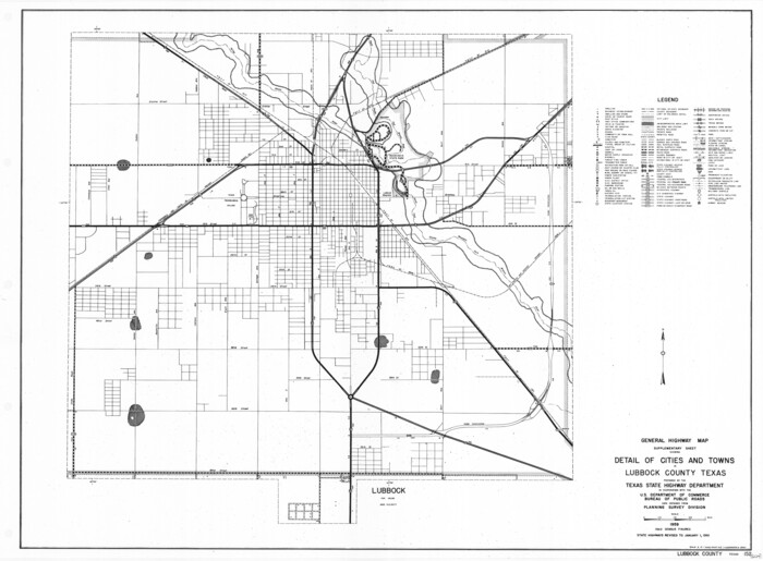
General Highway Map. Detail of Cities and Towns in Lubbock County, Texas [Lubbock and vicinity]
Print $20.00
General Highway Map. Detail of Cities and Towns in Lubbock County, Texas [Lubbock and vicinity]
1961
Size: 18.2 x 24.7 inches
79579
Lubbock County Working Sketch 6

Print $20.00
- Digital $50.00
Lubbock County Working Sketch 6
1959
Size: 25.1 x 22.4 inches
70666
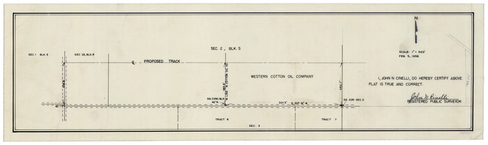
[Section 2, Block S]
Print $20.00
- Digital $50.00
[Section 2, Block S]
1958
Size: 22.2 x 6.8 inches
92860
Rhyne Simpson Addition No. 2, City of Lubbock Section 3, Block O

Print $20.00
- Digital $50.00
Rhyne Simpson Addition No. 2, City of Lubbock Section 3, Block O
1957
Size: 11.7 x 18.2 inches
92752
Plat Showing Survey for Harvest Queen Mills in Sec. 2 Blk. A & Sec. 4 Blk. O Lubbock County, Texas

Print $20.00
- Digital $50.00
Plat Showing Survey for Harvest Queen Mills in Sec. 2 Blk. A & Sec. 4 Blk. O Lubbock County, Texas
1956
Size: 36.9 x 39.5 inches
89893
Subdivision of Tract 2, Soash-White Industrial Addition, Part of Southeast Quarter, Section 2, Block E (Geo. W. Soash - J. B. White, Owners)

Print $20.00
- Digital $50.00
Subdivision of Tract 2, Soash-White Industrial Addition, Part of Southeast Quarter, Section 2, Block E (Geo. W. Soash - J. B. White, Owners)
1956
Size: 22.8 x 17.6 inches
92775
Soash-White Industrial Addition Located on Southeast Quarter of Section 2, Block E (Geo. W. Soash and J. B. White, Owners)

Print $20.00
- Digital $50.00
Soash-White Industrial Addition Located on Southeast Quarter of Section 2, Block E (Geo. W. Soash and J. B. White, Owners)
1956
Size: 37.3 x 23.3 inches
92732
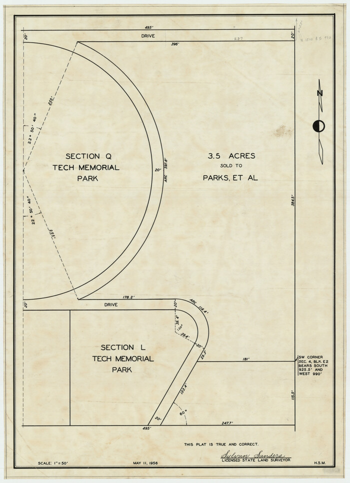
[Sections Q, L Tech Memorial Park]
Print $20.00
- Digital $50.00
[Sections Q, L Tech Memorial Park]
1956
Size: 13.0 x 17.8 inches
92303
Property of Hobbs Trailers Manufacturing Company

Print $20.00
- Digital $50.00
Property of Hobbs Trailers Manufacturing Company
1956
Size: 36.6 x 18.9 inches
92733
Lakeview Addition to the City of Shallowater out of the Southeast 1/4 of Section 27, Block D5

Print $3.00
- Digital $50.00
Lakeview Addition to the City of Shallowater out of the Southeast 1/4 of Section 27, Block D5
1955
Size: 17.9 x 11.6 inches
92870
W. C. Baze Subdivision a part of Tracts 25, 26, 27 and 28, Ross Addition to City of Idalou, Lubbock Co.

Print $20.00
- Digital $50.00
W. C. Baze Subdivision a part of Tracts 25, 26, 27 and 28, Ross Addition to City of Idalou, Lubbock Co.
1955
Size: 9.2 x 18.9 inches
92761
Survey of Blocks 1, 2, 3, 4, 5, Merritt and Wild Addition

Print $20.00
- Digital $50.00
Survey of Blocks 1, 2, 3, 4, 5, Merritt and Wild Addition
1955
Size: 23.5 x 18.3 inches
92727
Gordon Addition to Idalou

Print $20.00
- Digital $50.00
Gordon Addition to Idalou
1954
Size: 22.6 x 10.8 inches
92827
First Installment Gordon Addition to Idalou

Print $20.00
- Digital $50.00
First Installment Gordon Addition to Idalou
1954
Size: 22.8 x 10.8 inches
92828
Block 39 of the Brown Subdivision being a part of the Northeast Quarter Section 4, Block O

Print $20.00
- Digital $50.00
Block 39 of the Brown Subdivision being a part of the Northeast Quarter Section 4, Block O
1954
Size: 14.8 x 14.2 inches
92822
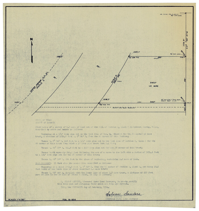
[Plat showing 1.0 acre of land out of the NE/4 of Section 2, Block E]
Print $3.00
- Digital $50.00
[Plat showing 1.0 acre of land out of the NE/4 of Section 2, Block E]
1954
Size: 9.6 x 10.2 inches
92706
Rhyne Simpson Quirt Avenue Addition to the City of Lubbock

Print $20.00
- Digital $50.00
Rhyne Simpson Quirt Avenue Addition to the City of Lubbock
1954
Size: 19.3 x 40.5 inches
92877
Preliminary Re-Plat of Lots 13-20, 45-52, 77-84, and 97-104 James Subdivision

Print $2.00
- Digital $50.00
Preliminary Re-Plat of Lots 13-20, 45-52, 77-84, and 97-104 James Subdivision
1953
Size: 8.7 x 11.3 inches
93221
Lubbock County Working Sketch 10
Print $20.00
- Digital $50.00
Lubbock County Working Sketch 10
1994
-
Size
21.8 x 30.1 inches
-
Map/Doc
70670
-
Creation Date
1994
Lubbock County Working Sketch 9
Print $40.00
- Digital $50.00
Lubbock County Working Sketch 9
1990
-
Size
28.5 x 57.3 inches
-
Map/Doc
70669
-
Creation Date
1990
Lubbock County Working Sketch 8
Print $20.00
- Digital $50.00
Lubbock County Working Sketch 8
1989
-
Size
27.4 x 25.2 inches
-
Map/Doc
70668
-
Creation Date
1989
Lubbock County

Print $20.00
- Digital $50.00
Lubbock County
1968
-
Size
42.1 x 34.1 inches
-
Map/Doc
73226
-
Creation Date
1968
Lubbock County

Print $20.00
- Digital $50.00
Lubbock County
1968
-
Size
43.5 x 35.4 inches
-
Map/Doc
77359
-
Creation Date
1968
Lubbock County

Print $20.00
- Digital $50.00
Lubbock County
1968
-
Size
44.2 x 35.8 inches
-
Map/Doc
95576
-
Creation Date
1968
Lubbock County Working Sketch Graphic Index
Print $20.00
- Digital $50.00
Lubbock County Working Sketch Graphic Index
1968
-
Size
41.3 x 33.7 inches
-
Map/Doc
76626
-
Creation Date
1968
Lubbock County Working Sketch 7
Print $20.00
- Digital $50.00
Lubbock County Working Sketch 7
1964
-
Size
21.9 x 25.3 inches
-
Map/Doc
70667
-
Creation Date
1964
Revised Plat, Section J, Tech Memorial Park, Inc., Infants Garden
Print $20.00
- Digital $50.00
Revised Plat, Section J, Tech Memorial Park, Inc., Infants Garden
1961
-
Size
29.1 x 33.7 inches
-
Map/Doc
92786
-
Creation Date
1961
General Highway Map, Lubbock County, Texas
Print $20.00
General Highway Map, Lubbock County, Texas
1961
-
Size
18.1 x 24.6 inches
-
Map/Doc
79578
-
Creation Date
1961
General Highway Map. Detail of Cities and Towns in Lubbock County, Texas [Lubbock and vicinity]
Print $20.00
General Highway Map. Detail of Cities and Towns in Lubbock County, Texas [Lubbock and vicinity]
1961
-
Size
18.2 x 24.7 inches
-
Map/Doc
79579
-
Creation Date
1961
Lubbock County Working Sketch 6
Print $20.00
- Digital $50.00
Lubbock County Working Sketch 6
1959
-
Size
25.1 x 22.4 inches
-
Map/Doc
70666
-
Creation Date
1959
[Section 2, Block S]
Print $20.00
- Digital $50.00
[Section 2, Block S]
1958
-
Size
22.2 x 6.8 inches
-
Map/Doc
92860
-
Creation Date
1958
Rhyne Simpson Addition No. 2, City of Lubbock Section 3, Block O
Print $20.00
- Digital $50.00
Rhyne Simpson Addition No. 2, City of Lubbock Section 3, Block O
1957
-
Size
11.7 x 18.2 inches
-
Map/Doc
92752
-
Creation Date
1957
Anton Quadrangle

Print $20.00
- Digital $50.00
Anton Quadrangle
1957
-
Size
18.1 x 22.1 inches
-
Map/Doc
92814
-
Creation Date
1957
Plat Showing Survey for Harvest Queen Mills in Sec. 2 Blk. A & Sec. 4 Blk. O Lubbock County, Texas
Print $20.00
- Digital $50.00
Plat Showing Survey for Harvest Queen Mills in Sec. 2 Blk. A & Sec. 4 Blk. O Lubbock County, Texas
1956
-
Size
36.9 x 39.5 inches
-
Map/Doc
89893
-
Creation Date
1956
Subdivision of Tract 2, Soash-White Industrial Addition, Part of Southeast Quarter, Section 2, Block E (Geo. W. Soash - J. B. White, Owners)
Print $20.00
- Digital $50.00
Subdivision of Tract 2, Soash-White Industrial Addition, Part of Southeast Quarter, Section 2, Block E (Geo. W. Soash - J. B. White, Owners)
1956
-
Size
22.8 x 17.6 inches
-
Map/Doc
92775
-
Creation Date
1956
Soash-White Industrial Addition Located on Southeast Quarter of Section 2, Block E (Geo. W. Soash and J. B. White, Owners)
Print $20.00
- Digital $50.00
Soash-White Industrial Addition Located on Southeast Quarter of Section 2, Block E (Geo. W. Soash and J. B. White, Owners)
1956
-
Size
37.3 x 23.3 inches
-
Map/Doc
92732
-
Creation Date
1956
[Sections Q, L Tech Memorial Park]
Print $20.00
- Digital $50.00
[Sections Q, L Tech Memorial Park]
1956
-
Size
13.0 x 17.8 inches
-
Map/Doc
92303
-
Creation Date
1956
Property of Hobbs Trailers Manufacturing Company
Print $20.00
- Digital $50.00
Property of Hobbs Trailers Manufacturing Company
1956
-
Size
36.6 x 18.9 inches
-
Map/Doc
92733
-
Creation Date
1956
Lakeview Addition to the City of Shallowater out of the Southeast 1/4 of Section 27, Block D5
Print $3.00
- Digital $50.00
Lakeview Addition to the City of Shallowater out of the Southeast 1/4 of Section 27, Block D5
1955
-
Size
17.9 x 11.6 inches
-
Map/Doc
92870
-
Creation Date
1955
W. C. Baze Subdivision a part of Tracts 25, 26, 27 and 28, Ross Addition to City of Idalou, Lubbock Co.
Print $20.00
- Digital $50.00
W. C. Baze Subdivision a part of Tracts 25, 26, 27 and 28, Ross Addition to City of Idalou, Lubbock Co.
1955
-
Size
9.2 x 18.9 inches
-
Map/Doc
92761
-
Creation Date
1955
Survey of Blocks 1, 2, 3, 4, 5, Merritt and Wild Addition
Print $20.00
- Digital $50.00
Survey of Blocks 1, 2, 3, 4, 5, Merritt and Wild Addition
1955
-
Size
23.5 x 18.3 inches
-
Map/Doc
92727
-
Creation Date
1955
Gordon Addition to Idalou
Print $20.00
- Digital $50.00
Gordon Addition to Idalou
1954
-
Size
22.6 x 10.8 inches
-
Map/Doc
92827
-
Creation Date
1954
First Installment Gordon Addition to Idalou
Print $20.00
- Digital $50.00
First Installment Gordon Addition to Idalou
1954
-
Size
22.8 x 10.8 inches
-
Map/Doc
92828
-
Creation Date
1954
Block 39 of the Brown Subdivision being a part of the Northeast Quarter Section 4, Block O
Print $20.00
- Digital $50.00
Block 39 of the Brown Subdivision being a part of the Northeast Quarter Section 4, Block O
1954
-
Size
14.8 x 14.2 inches
-
Map/Doc
92822
-
Creation Date
1954
[Plat showing 1.0 acre of land out of the NE/4 of Section 2, Block E]
Print $3.00
- Digital $50.00
[Plat showing 1.0 acre of land out of the NE/4 of Section 2, Block E]
1954
-
Size
9.6 x 10.2 inches
-
Map/Doc
92706
-
Creation Date
1954
Rhyne Simpson Quirt Avenue Addition to the City of Lubbock
Print $20.00
- Digital $50.00
Rhyne Simpson Quirt Avenue Addition to the City of Lubbock
1954
-
Size
19.3 x 40.5 inches
-
Map/Doc
92877
-
Creation Date
1954
Preliminary Re-Plat of Lots 13-20, 45-52, 77-84, and 97-104 James Subdivision
Print $2.00
- Digital $50.00
Preliminary Re-Plat of Lots 13-20, 45-52, 77-84, and 97-104 James Subdivision
1953
-
Size
8.7 x 11.3 inches
-
Map/Doc
93221
-
Creation Date
1953