Midland County Rolled Sketch 5

Print $20.00
- Digital $50.00
Midland County Rolled Sketch 5
Size: 35.3 x 44.8 inches
10695
Midland County Rolled Sketch 4

Print $40.00
- Digital $50.00
Midland County Rolled Sketch 4
Size: 43.5 x 85.6 inches
10696
Midland County Sketch File 9

Print $20.00
- Digital $50.00
Midland County Sketch File 9
Size: 19.7 x 29.2 inches
12085
Midland County Sketch File M

Print $20.00
- Digital $50.00
Midland County Sketch File M
Size: 18.5 x 14.9 inches
12090
Midland County Sketch File 5

Print $2.00
- Digital $50.00
Midland County Sketch File 5
Size: 8.4 x 3.5 inches
31575
Midland County Sketch File 18

Print $4.00
- Digital $50.00
Midland County Sketch File 18
Size: 14.7 x 8.1 inches
31585
Midland County Boundary File 1

Print $40.00
- Digital $50.00
Midland County Boundary File 1
Size: 7.0 x 6.6 inches
57140
Midland County Boundary File 1a

Print $4.00
- Digital $50.00
Midland County Boundary File 1a
Size: 9.5 x 6.0 inches
57160
Midland County Boundary File 2

Print $24.00
- Digital $50.00
Midland County Boundary File 2
Size: 8.9 x 5.5 inches
57162
Midland County Boundary File 3

Print $4.00
- Digital $50.00
Midland County Boundary File 3
Size: 8.2 x 8.3 inches
57174
Midland County Boundary File 4

Print $18.00
- Digital $50.00
Midland County Boundary File 4
Size: 8.8 x 8.0 inches
57176
Midland County Boundary File 4a

Print $40.00
- Digital $50.00
Midland County Boundary File 4a
Size: 36.2 x 54.5 inches
57185
Midland County Boundary File 4b

Print $18.00
- Digital $50.00
Midland County Boundary File 4b
Size: 13.6 x 9.0 inches
57186
Midland County Boundary File 5

Print $6.00
- Digital $50.00
Midland County Boundary File 5
Size: 9.6 x 6.0 inches
57195
Glasscock County Working Sketch 4

Print $20.00
- Digital $50.00
Glasscock County Working Sketch 4
Size: 15.7 x 25.9 inches
63177
Midland County Rolled Sketch 9

Print $40.00
- Digital $50.00
Midland County Rolled Sketch 9
Size: 73.4 x 17.3 inches
6766
Midland County Rolled Sketch 11

Print $20.00
- Digital $50.00
Midland County Rolled Sketch 11
Size: 45.7 x 26.2 inches
6767
Midland County Rolled Sketch 13

Print $20.00
- Digital $50.00
Midland County Rolled Sketch 13
Size: 22.0 x 19.4 inches
6768
Midland County Working Sketch 1

Print $20.00
- Digital $50.00
Midland County Working Sketch 1
Size: 26.8 x 8.7 inches
70981
Midland County Working Sketch 2

Print $20.00
- Digital $50.00
Midland County Working Sketch 2
Size: 40.4 x 25.2 inches
70982
Midland County Working Sketch 3

Print $20.00
- Digital $50.00
Midland County Working Sketch 3
Size: 19.5 x 35.2 inches
70983
Midland County Working Sketch 4

Print $20.00
- Digital $50.00
Midland County Working Sketch 4
Size: 20.3 x 44.3 inches
70984
Midland County Working Sketch 19a

Print $20.00
- Digital $50.00
Midland County Working Sketch 19a
Size: 20.2 x 23.4 inches
71000
Midland County Rolled Sketch 14

Print $40.00
- Digital $50.00
Midland County Rolled Sketch 14
Size: 56.6 x 43.5 inches
73574
Midland County Rolled Sketch 14

Print $40.00
- Digital $50.00
Midland County Rolled Sketch 14
Size: 102.9 x 43.8 inches
73579
Map of lands owned by R.E. Montgomery in Martin and Andrews County, Texas

Print $20.00
- Digital $50.00
Map of lands owned by R.E. Montgomery in Martin and Andrews County, Texas
Size: 20.0 x 24.5 inches
75764
Andrews County Rolled Sketch 42

Print $20.00
- Digital $50.00
Andrews County Rolled Sketch 42
Size: 27.3 x 36.0 inches
77182
Revised Sectional Map Number 2, Lands in Texas and Pacific Railway Reservation From Westbrook Station in Mitchell County to Metz Station in Ector County

Print $20.00
- Digital $50.00
Revised Sectional Map Number 2, Lands in Texas and Pacific Railway Reservation From Westbrook Station in Mitchell County to Metz Station in Ector County
Size: 25.1 x 19.6 inches
91366
[Blocks 36, 37 Township 2 South]
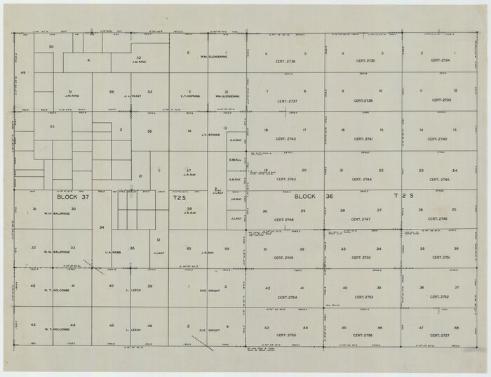
Print $20.00
- Digital $50.00
[Blocks 36, 37 Township 2 South]
Size: 24.6 x 18.9 inches
92320
Midland County Rolled Sketch 5
Print $20.00
- Digital $50.00
Midland County Rolled Sketch 5
-
Size
35.3 x 44.8 inches
-
Map/Doc
10695
Midland County Rolled Sketch 4
Print $40.00
- Digital $50.00
Midland County Rolled Sketch 4
-
Size
43.5 x 85.6 inches
-
Map/Doc
10696
Martin County Sketch File 9

Print $20.00
Martin County Sketch File 9
-
Size
19.7 x 27.4 inches
-
Map/Doc
12029
Midland County Sketch File 9
Print $20.00
- Digital $50.00
Midland County Sketch File 9
-
Size
19.7 x 29.2 inches
-
Map/Doc
12085
Midland County Sketch File M
Print $20.00
- Digital $50.00
Midland County Sketch File M
-
Size
18.5 x 14.9 inches
-
Map/Doc
12090
Midland County Sketch File 5
Print $2.00
- Digital $50.00
Midland County Sketch File 5
-
Size
8.4 x 3.5 inches
-
Map/Doc
31575
Midland County Sketch File 18
Print $4.00
- Digital $50.00
Midland County Sketch File 18
-
Size
14.7 x 8.1 inches
-
Map/Doc
31585
Midland County Boundary File 1
Print $40.00
- Digital $50.00
Midland County Boundary File 1
-
Size
7.0 x 6.6 inches
-
Map/Doc
57140
Midland County Boundary File 1a
Print $4.00
- Digital $50.00
Midland County Boundary File 1a
-
Size
9.5 x 6.0 inches
-
Map/Doc
57160
Midland County Boundary File 2
Print $24.00
- Digital $50.00
Midland County Boundary File 2
-
Size
8.9 x 5.5 inches
-
Map/Doc
57162
Midland County Boundary File 3
Print $4.00
- Digital $50.00
Midland County Boundary File 3
-
Size
8.2 x 8.3 inches
-
Map/Doc
57174
Midland County Boundary File 4
Print $18.00
- Digital $50.00
Midland County Boundary File 4
-
Size
8.8 x 8.0 inches
-
Map/Doc
57176
Midland County Boundary File 4a
Print $40.00
- Digital $50.00
Midland County Boundary File 4a
-
Size
36.2 x 54.5 inches
-
Map/Doc
57185
Midland County Boundary File 4b
Print $18.00
- Digital $50.00
Midland County Boundary File 4b
-
Size
13.6 x 9.0 inches
-
Map/Doc
57186
Midland County Boundary File 5
Print $6.00
- Digital $50.00
Midland County Boundary File 5
-
Size
9.6 x 6.0 inches
-
Map/Doc
57195
Glasscock County Working Sketch 4
Print $20.00
- Digital $50.00
Glasscock County Working Sketch 4
-
Size
15.7 x 25.9 inches
-
Map/Doc
63177
Midland County Rolled Sketch 9
Print $40.00
- Digital $50.00
Midland County Rolled Sketch 9
-
Size
73.4 x 17.3 inches
-
Map/Doc
6766
Midland County Rolled Sketch 11
Print $20.00
- Digital $50.00
Midland County Rolled Sketch 11
-
Size
45.7 x 26.2 inches
-
Map/Doc
6767
Midland County Rolled Sketch 13
Print $20.00
- Digital $50.00
Midland County Rolled Sketch 13
-
Size
22.0 x 19.4 inches
-
Map/Doc
6768
Midland County Working Sketch 1
Print $20.00
- Digital $50.00
Midland County Working Sketch 1
-
Size
26.8 x 8.7 inches
-
Map/Doc
70981
Midland County Working Sketch 2
Print $20.00
- Digital $50.00
Midland County Working Sketch 2
-
Size
40.4 x 25.2 inches
-
Map/Doc
70982
Midland County Working Sketch 3
Print $20.00
- Digital $50.00
Midland County Working Sketch 3
-
Size
19.5 x 35.2 inches
-
Map/Doc
70983
Midland County Working Sketch 4
Print $20.00
- Digital $50.00
Midland County Working Sketch 4
-
Size
20.3 x 44.3 inches
-
Map/Doc
70984
Midland County Working Sketch 19a
Print $20.00
- Digital $50.00
Midland County Working Sketch 19a
-
Size
20.2 x 23.4 inches
-
Map/Doc
71000
Midland County Rolled Sketch 14
Print $40.00
- Digital $50.00
Midland County Rolled Sketch 14
-
Size
56.6 x 43.5 inches
-
Map/Doc
73574
Midland County Rolled Sketch 14
Print $40.00
- Digital $50.00
Midland County Rolled Sketch 14
-
Size
102.9 x 43.8 inches
-
Map/Doc
73579
Map of lands owned by R.E. Montgomery in Martin and Andrews County, Texas
Print $20.00
- Digital $50.00
Map of lands owned by R.E. Montgomery in Martin and Andrews County, Texas
-
Size
20.0 x 24.5 inches
-
Map/Doc
75764
Andrews County Rolled Sketch 42
Print $20.00
- Digital $50.00
Andrews County Rolled Sketch 42
-
Size
27.3 x 36.0 inches
-
Map/Doc
77182
Revised Sectional Map Number 2, Lands in Texas and Pacific Railway Reservation From Westbrook Station in Mitchell County to Metz Station in Ector County
Print $20.00
- Digital $50.00
Revised Sectional Map Number 2, Lands in Texas and Pacific Railway Reservation From Westbrook Station in Mitchell County to Metz Station in Ector County
-
Size
25.1 x 19.6 inches
-
Map/Doc
91366
[Blocks 36, 37 Township 2 South]
Print $20.00
- Digital $50.00
[Blocks 36, 37 Township 2 South]
-
Size
24.6 x 18.9 inches
-
Map/Doc
92320