[T. J. Chambers' grant]
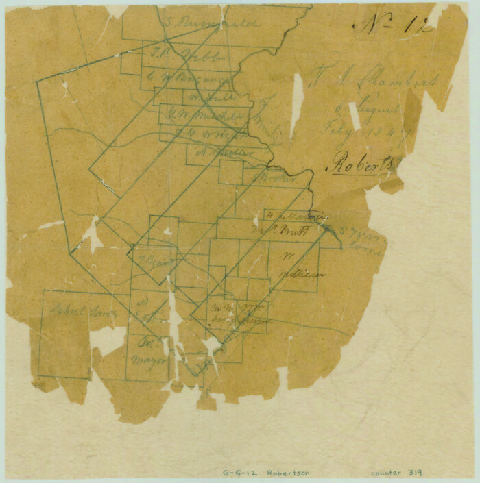
Print $2.00
- Digital $50.00
[T. J. Chambers' grant]
1847
Size: 7.1 x 7.1 inches
319
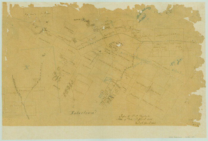
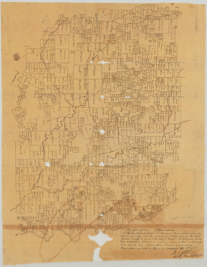
[Surveys in the Robertson District along the Trinity River and Richland Creek]
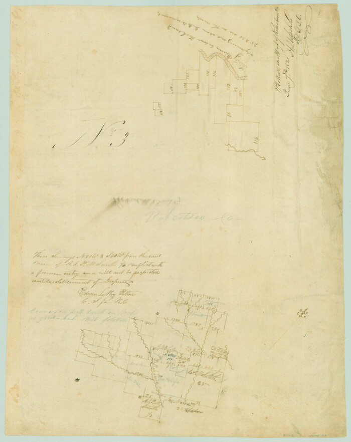
Print $20.00
- Digital $50.00
[Surveys in the Robertson District along the Trinity River and Richland Creek]
1841
Size: 15.3 x 12.2 inches
104
[Surveys along the Trinity River]
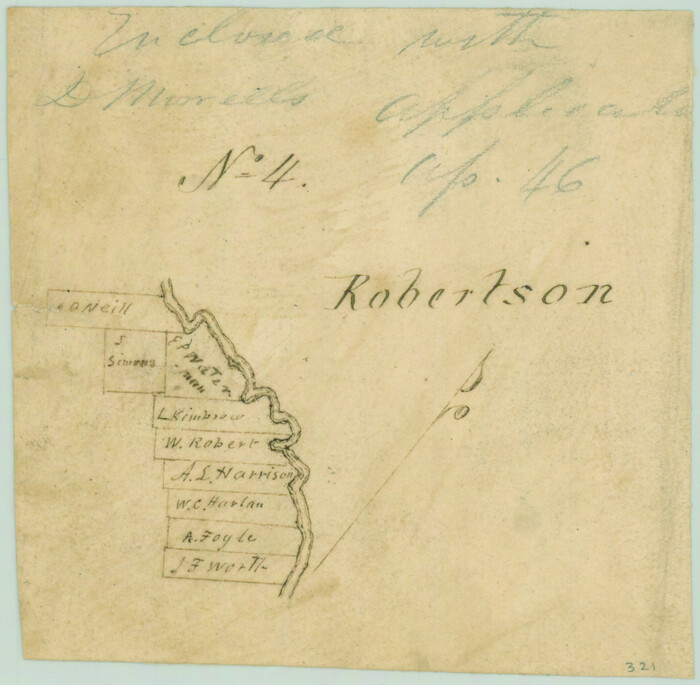
Print $2.00
- Digital $50.00
[Surveys along the Trinity River]
Size: 3.6 x 3.7 inches
321
[Surveys along the Nacogdoches River, Richland Creek, and the Trinity River]
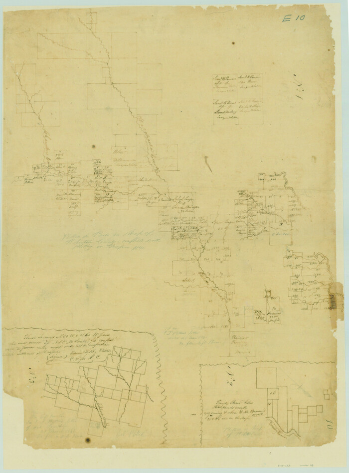
Print $20.00
- Digital $50.00
[Surveys along the Nacogdoches River, Richland Creek, and the Trinity River]
1840
Size: 24.2 x 17.9 inches
85
[Surveys along Tehuacano and Grindstone Creek, drawings X and Y]
Print $20.00
- Digital $50.00
[Surveys along Tehuacano and Grindstone Creek, drawings X and Y]
1846
Size: 12.4 x 18.3 inches
299
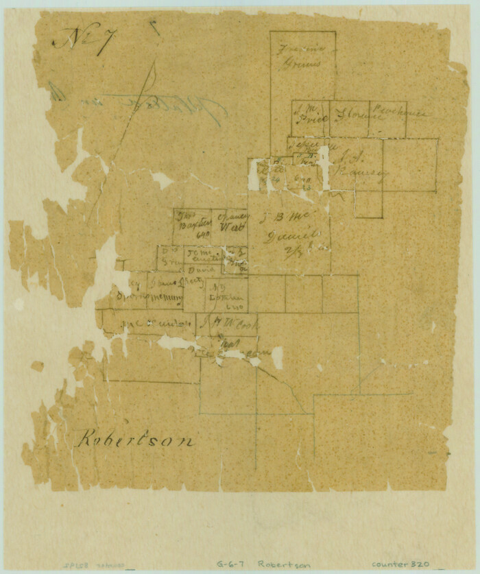
[Surveys along Richland Creek]
Print $2.00
- Digital $50.00
[Surveys along Richland Creek]
Size: 7.2 x 6.0 inches
320
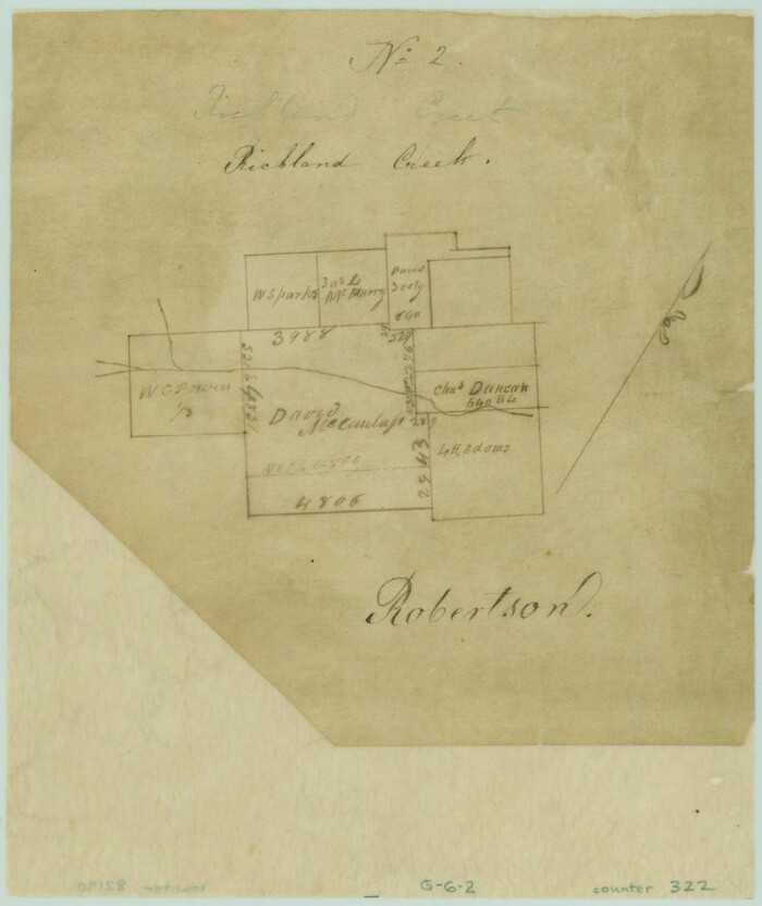
[Surveys along Richland Creek]
Print $2.00
- Digital $50.00
[Surveys along Richland Creek]
Size: 6.0 x 5.0 inches
322
[Map of the Line of the H. & Texas Cen. Railway from the Navasota River, 72 1/2 Miles from Houston, to Corsicana in Navarro Co., 211 mls from Houston]
Print $40.00
- Digital $50.00
[Map of the Line of the H. & Texas Cen. Railway from the Navasota River, 72 1/2 Miles from Houston, to Corsicana in Navarro Co., 211 mls from Houston]
Size: 75.6 x 39.6 inches
64087
[Map of Navarro County]
Print $20.00
- Digital $50.00
[Map of Navarro County]
1858
Size: 18.0 x 23.5 inches
81900
Trinity River, Wildcat Ferry Sheet

Print $20.00
- Digital $50.00
Trinity River, Wildcat Ferry Sheet
1928
Size: 41.5 x 40.9 inches
65182
Trinity River, Walker's Lake Sheet/Richland Creek

Print $20.00
- Digital $50.00
Trinity River, Walker's Lake Sheet/Richland Creek
1931
Size: 25.9 x 41.2 inches
65226
Trinity River, Trinidad Sheet

Print $20.00
- Digital $50.00
Trinity River, Trinidad Sheet
1928
Size: 39.0 x 46.3 inches
65183
Trinity River, South Extension Porters Bluff Sheet

Print $20.00
- Digital $50.00
Trinity River, South Extension Porters Bluff Sheet
1925
Size: 16.3 x 24.4 inches
69690
Trinity River, Powell Sheet/Chambers Creek

Print $20.00
- Digital $50.00
Trinity River, Powell Sheet/Chambers Creek
1931
Size: 32.6 x 37.9 inches
65230
Trinity River, Post Oak Creek Sheet

Print $4.00
- Digital $50.00
Trinity River, Post Oak Creek Sheet
1930
Size: 20.6 x 23.0 inches
65227
Trinity River, Porters Bluff Sheet

Print $20.00
- Digital $50.00
Trinity River, Porters Bluff Sheet
1925
Size: 27.4 x 23.6 inches
69689
Trinity River, Onion Creek Station Sheet/Chambers Creek

Print $6.00
- Digital $50.00
Trinity River, Onion Creek Station Sheet/Chambers Creek
1931
Size: 35.1 x 32.4 inches
65234
Trinity River, Oliver Crossing Sheet/Chambers Creek

Print $6.00
- Digital $50.00
Trinity River, Oliver Crossing Sheet/Chambers Creek
1931
Size: 30.1 x 28.2 inches
65231
Trinity River, North Extension Bazzette Sheet

Print $20.00
- Digital $50.00
Trinity River, North Extension Bazzette Sheet
1925
Size: 16.3 x 24.3 inches
69691
Trinity River, Map of J. B. Bradley's Levee in Valley of Cummins Creek about 2 1/2 Miles South of Rice Showing Proposed Change of Location

Print $2.00
- Digital $50.00
Trinity River, Map of J. B. Bradley's Levee in Valley of Cummins Creek about 2 1/2 Miles South of Rice Showing Proposed Change of Location
1950
Size: 13.9 x 16.1 inches
65246
Trinity River, Levee Improvement Districts, Widths of Floodways/Chambers Creek

Print $6.00
- Digital $50.00
Trinity River, Levee Improvement Districts, Widths of Floodways/Chambers Creek
1921
Size: 24.9 x 31.3 inches
65256
Trinity River, Levee Improvement Districts, Widths of Floodways

Print $20.00
- Digital $50.00
Trinity River, Levee Improvement Districts, Widths of Floodways
1923
Size: 37.6 x 28.2 inches
65253
Trinity River, Levee Improvement Districts Widths of Floodways/Chambers Creek

Print $4.00
- Digital $50.00
Trinity River, Levee Improvement Districts Widths of Floodways/Chambers Creek
1921
Size: 18.6 x 28.3 inches
65247
Trinity River, Levee Improvement Districts Widths of Floodways

Print $6.00
- Digital $50.00
Trinity River, Levee Improvement Districts Widths of Floodways
1920
Size: 33.9 x 23.0 inches
65249
Trinity River, Emhouse Sheet/Chambers Creek

Print $6.00
- Digital $50.00
Trinity River, Emhouse Sheet/Chambers Creek
1931
Size: 35.3 x 34.8 inches
65232
Trinity River, Emhouse Sheet/Chambers Creek

Print $20.00
- Digital $50.00
Trinity River, Emhouse Sheet/Chambers Creek
1931
Size: 35.8 x 35.3 inches
65233
Trinity River, Club House Sheet

Print $20.00
- Digital $50.00
Trinity River, Club House Sheet
1925
Size: 27.7 x 23.7 inches
69688
Trinity River, Carl Switch Sheet/Chambers Creek

Print $20.00
- Digital $50.00
Trinity River, Carl Switch Sheet/Chambers Creek
1930
Size: 39.2 x 37.8 inches
65216
Trinity River, Carl Switch Sheet/Chambers Creek

Print $4.00
- Digital $50.00
Trinity River, Carl Switch Sheet/Chambers Creek
1926
Size: 27.9 x 27.0 inches
65217
Trinity River, Bulletin 30C/Richland Creek

Print $6.00
- Digital $50.00
Trinity River, Bulletin 30C/Richland Creek
1937
Size: 11.7 x 31.8 inches
65245
[T. J. Chambers' grant]
Print $2.00
- Digital $50.00
[T. J. Chambers' grant]
1847
-
Size
7.1 x 7.1 inches
-
Map/Doc
319
-
Creation Date
1847
[Surveys in the Robertson District along the Trinity River and Richland Creek]
Print $20.00
- Digital $50.00
[Surveys in the Robertson District along the Trinity River and Richland Creek]
1841
-
Size
15.3 x 12.2 inches
-
Map/Doc
104
-
Creation Date
1841
[Surveys along the Trinity River]
Print $2.00
- Digital $50.00
[Surveys along the Trinity River]
-
Size
3.6 x 3.7 inches
-
Map/Doc
321
[Surveys along the Nacogdoches River, Richland Creek, and the Trinity River]
Print $20.00
- Digital $50.00
[Surveys along the Nacogdoches River, Richland Creek, and the Trinity River]
1840
-
Size
24.2 x 17.9 inches
-
Map/Doc
85
-
Creation Date
1840
[Surveys along Tehuacano and Grindstone Creek, drawings X and Y]
Print $20.00
- Digital $50.00
[Surveys along Tehuacano and Grindstone Creek, drawings X and Y]
1846
-
Size
12.4 x 18.3 inches
-
Map/Doc
299
-
Creation Date
1846
[Surveys along Richland Creek]
Print $2.00
- Digital $50.00
[Surveys along Richland Creek]
-
Size
7.2 x 6.0 inches
-
Map/Doc
320
[Surveys along Richland Creek]
Print $2.00
- Digital $50.00
[Surveys along Richland Creek]
-
Size
6.0 x 5.0 inches
-
Map/Doc
322
[Map of the Line of the H. & Texas Cen. Railway from the Navasota River, 72 1/2 Miles from Houston, to Corsicana in Navarro Co., 211 mls from Houston]
Print $40.00
- Digital $50.00
[Map of the Line of the H. & Texas Cen. Railway from the Navasota River, 72 1/2 Miles from Houston, to Corsicana in Navarro Co., 211 mls from Houston]
-
Size
75.6 x 39.6 inches
-
Map/Doc
64087
[Map of Navarro County]
Print $20.00
- Digital $50.00
[Map of Navarro County]
1858
-
Size
18.0 x 23.5 inches
-
Map/Doc
81900
-
Creation Date
1858
Trinity River, Wildcat Ferry Sheet
Print $20.00
- Digital $50.00
Trinity River, Wildcat Ferry Sheet
1928
-
Size
41.5 x 40.9 inches
-
Map/Doc
65182
-
Creation Date
1928
Trinity River, Walker's Lake Sheet/Richland Creek
Print $20.00
- Digital $50.00
Trinity River, Walker's Lake Sheet/Richland Creek
1931
-
Size
25.9 x 41.2 inches
-
Map/Doc
65226
-
Creation Date
1931
Trinity River, Trinidad Sheet
Print $20.00
- Digital $50.00
Trinity River, Trinidad Sheet
1928
-
Size
39.0 x 46.3 inches
-
Map/Doc
65183
-
Creation Date
1928
Trinity River, South Extension Porters Bluff Sheet
Print $20.00
- Digital $50.00
Trinity River, South Extension Porters Bluff Sheet
1925
-
Size
16.3 x 24.4 inches
-
Map/Doc
69690
-
Creation Date
1925
Trinity River, Powell Sheet/Chambers Creek
Print $20.00
- Digital $50.00
Trinity River, Powell Sheet/Chambers Creek
1931
-
Size
32.6 x 37.9 inches
-
Map/Doc
65230
-
Creation Date
1931
Trinity River, Post Oak Creek Sheet
Print $4.00
- Digital $50.00
Trinity River, Post Oak Creek Sheet
1930
-
Size
20.6 x 23.0 inches
-
Map/Doc
65227
-
Creation Date
1930
Trinity River, Porters Bluff Sheet
Print $20.00
- Digital $50.00
Trinity River, Porters Bluff Sheet
1925
-
Size
27.4 x 23.6 inches
-
Map/Doc
69689
-
Creation Date
1925
Trinity River, Onion Creek Station Sheet/Chambers Creek
Print $6.00
- Digital $50.00
Trinity River, Onion Creek Station Sheet/Chambers Creek
1931
-
Size
35.1 x 32.4 inches
-
Map/Doc
65234
-
Creation Date
1931
Trinity River, Oliver Crossing Sheet/Chambers Creek
Print $6.00
- Digital $50.00
Trinity River, Oliver Crossing Sheet/Chambers Creek
1931
-
Size
30.1 x 28.2 inches
-
Map/Doc
65231
-
Creation Date
1931
Trinity River, North Extension Bazzette Sheet
Print $20.00
- Digital $50.00
Trinity River, North Extension Bazzette Sheet
1925
-
Size
16.3 x 24.3 inches
-
Map/Doc
69691
-
Creation Date
1925
Trinity River, Map of J. B. Bradley's Levee in Valley of Cummins Creek about 2 1/2 Miles South of Rice Showing Proposed Change of Location
Print $2.00
- Digital $50.00
Trinity River, Map of J. B. Bradley's Levee in Valley of Cummins Creek about 2 1/2 Miles South of Rice Showing Proposed Change of Location
1950
-
Size
13.9 x 16.1 inches
-
Map/Doc
65246
-
Creation Date
1950
Trinity River, Levee Improvement Districts, Widths of Floodways/Chambers Creek
Print $6.00
- Digital $50.00
Trinity River, Levee Improvement Districts, Widths of Floodways/Chambers Creek
1921
-
Size
24.9 x 31.3 inches
-
Map/Doc
65256
-
Creation Date
1921
Trinity River, Levee Improvement Districts, Widths of Floodways
Print $20.00
- Digital $50.00
Trinity River, Levee Improvement Districts, Widths of Floodways
1923
-
Size
37.6 x 28.2 inches
-
Map/Doc
65253
-
Creation Date
1923
Trinity River, Levee Improvement Districts Widths of Floodways/Chambers Creek
Print $4.00
- Digital $50.00
Trinity River, Levee Improvement Districts Widths of Floodways/Chambers Creek
1921
-
Size
18.6 x 28.3 inches
-
Map/Doc
65247
-
Creation Date
1921
Trinity River, Levee Improvement Districts Widths of Floodways
Print $6.00
- Digital $50.00
Trinity River, Levee Improvement Districts Widths of Floodways
1920
-
Size
33.9 x 23.0 inches
-
Map/Doc
65249
-
Creation Date
1920
Trinity River, Emhouse Sheet/Chambers Creek
Print $6.00
- Digital $50.00
Trinity River, Emhouse Sheet/Chambers Creek
1931
-
Size
35.3 x 34.8 inches
-
Map/Doc
65232
-
Creation Date
1931
Trinity River, Emhouse Sheet/Chambers Creek
Print $20.00
- Digital $50.00
Trinity River, Emhouse Sheet/Chambers Creek
1931
-
Size
35.8 x 35.3 inches
-
Map/Doc
65233
-
Creation Date
1931
Trinity River, Club House Sheet
Print $20.00
- Digital $50.00
Trinity River, Club House Sheet
1925
-
Size
27.7 x 23.7 inches
-
Map/Doc
69688
-
Creation Date
1925
Trinity River, Carl Switch Sheet/Chambers Creek
Print $20.00
- Digital $50.00
Trinity River, Carl Switch Sheet/Chambers Creek
1930
-
Size
39.2 x 37.8 inches
-
Map/Doc
65216
-
Creation Date
1930
Trinity River, Carl Switch Sheet/Chambers Creek
Print $4.00
- Digital $50.00
Trinity River, Carl Switch Sheet/Chambers Creek
1926
-
Size
27.9 x 27.0 inches
-
Map/Doc
65217
-
Creation Date
1926
Trinity River, Bulletin 30C/Richland Creek
Print $6.00
- Digital $50.00
Trinity River, Bulletin 30C/Richland Creek
1937
-
Size
11.7 x 31.8 inches
-
Map/Doc
65245
-
Creation Date
1937