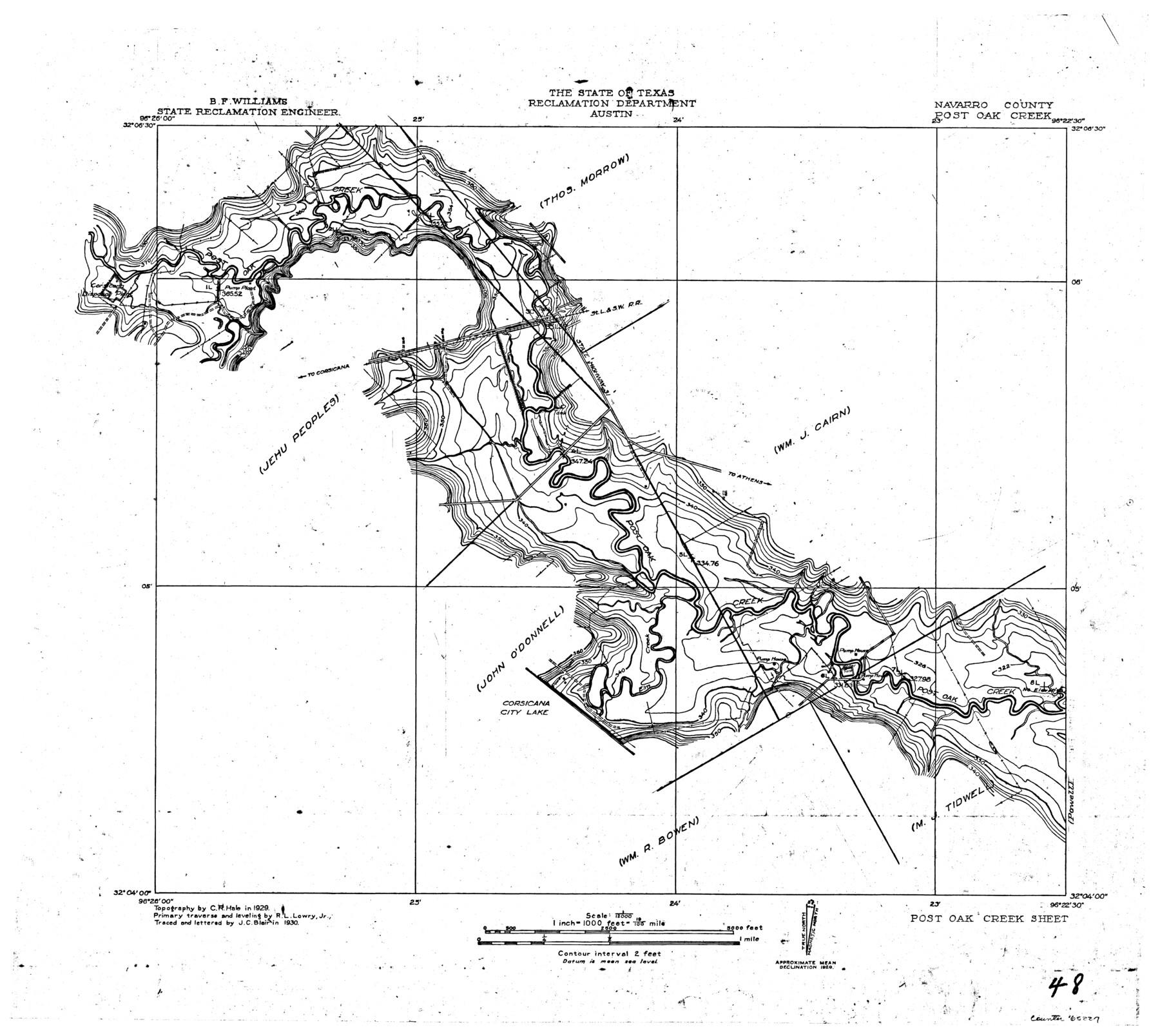
Trinity River, Post Oak Creek Sheet
- 
                          Map/Doc65227
- 
                            CollectionGeneral Map Collection
- 
                            Object Dates1930 (Creation Date)
- 
                            People and OrganizationsTexas State Reclamation Department (Publisher)Curtis R. Hale (Surveyor/Engineer)R.L. Lowry Jr. (Surveyor/Engineer)J.C. Blair (Compiler)J.C. Blair (Draftsman)
- 
                            CountiesNavarro
- 
                            SubjectsRiver Surveys Topographic
- 
                            Height x Width20.6 x 23.0 inches52.3 x 58.4 cm
- 
                            CommentsPost Oak Creek Sheet located west of the Powell Sheet.
Part of: General Map Collection
            Gregg County Sketch File 1G


                                            Print $2.00                    
                                             -                         Digital $50.00                                    
                Gregg County Sketch File 1G
Size 6.2 x 7.0 inches
                                Map/Doc 24549
            
            Lynn County Boundary File 7b


                                            Print $8.00                    
                                             -                         Digital $50.00                                    
                Lynn County Boundary File 7b
Size 11.3 x 8.6 inches
                                Map/Doc 56651
            
            Flight Mission No. BRA-16M, Frame 70, Jefferson County


                                            Print $20.00                    
                                             -                         Digital $50.00                                    
                Flight Mission No. BRA-16M, Frame 70, Jefferson County
1953
Size 18.6 x 22.3 inches
                                Map/Doc 85687
            
            Williamson County Working Sketch 18


                                            Print $20.00                    
                                             -                         Digital $50.00                                    
                Williamson County Working Sketch 18
1985
Size 26.1 x 26.6 inches
                                Map/Doc 72578
            
            McLennan County Sketch File 4a


                                            Print $6.00                    
                                             -                         Digital $50.00                                    
                McLennan County Sketch File 4a
Size 9.2 x 7.9 inches
                                Map/Doc 31237
            
            Lampasas County Working Sketch 12


                                            Print $6.00                    
                                             -                         Digital $50.00                                    
                Lampasas County Working Sketch 12
1969
Size 32.9 x 31.4 inches
                                Map/Doc 70289
            
            Galveston County Rolled Sketch 42


                                            Print $20.00                    
                                             -                         Digital $50.00                                    
                Galveston County Rolled Sketch 42
1982
Size 42.9 x 40.6 inches
                                Map/Doc 9021
            
            Cottle County Sketch File 3


                                            Print $4.00                    
                                             -                         Digital $50.00                                    
                Cottle County Sketch File 3
Size 10.0 x 8.4 inches
                                Map/Doc 19457
            
            Brewster County Sketch File N-3


                                            Print $6.00                    
                                             -                         Digital $50.00                                    
                Brewster County Sketch File N-3
1882
Size 8.6 x 7.6 inches
                                Map/Doc 15589
            
            Martin County Working Sketch 14


                                            Print $20.00                    
                                             -                         Digital $50.00                                    
                Martin County Working Sketch 14
1972
Size 39.6 x 22.6 inches
                                Map/Doc 70832
            You may also like
            Nueces County Rolled Sketch 29


                                            Print $20.00                    
                                             -                         Digital $50.00                                    
                Nueces County Rolled Sketch 29
1951
Size 25.0 x 22.7 inches
                                Map/Doc 6875
            
            Aransas County Sketch File 26


                                            Print $28.00                    
                                             -                         Digital $50.00                                    
                Aransas County Sketch File 26
1896
Size 5.2 x 4.7 inches
                                Map/Doc 13219
            
            Bivin's Addition to Amarillo, Texas, Survey 187, Block 2, A. B. & M., Potter County


                                            Print $20.00                    
                                             -                         Digital $50.00                                    
                Bivin's Addition to Amarillo, Texas, Survey 187, Block 2, A. B. & M., Potter County
Size 20.1 x 23.0 inches
                                Map/Doc 91739
            
            Map of Spearman Lands


                                            Print $20.00                    
                                             -                         Digital $50.00                                    
                Map of Spearman Lands
Size 20.0 x 15.4 inches
                                Map/Doc 90793
            
            Hall County Sketch File C2


                                            Print $6.00                    
                                             -                         Digital $50.00                                    
                Hall County Sketch File C2
1905
Size 14.4 x 9.0 inches
                                Map/Doc 24789
            
            Geological Map of the route explored by Capt. Jno. Pope, Corps of Topl. Engrs. near the 32nd Parallel of North Latitude from the Red River to the Rio Grande


                                            Print $20.00                    
                                             -                         Digital $50.00                                    
                Geological Map of the route explored by Capt. Jno. Pope, Corps of Topl. Engrs. near the 32nd Parallel of North Latitude from the Red River to the Rio Grande
1854
Size 11.1 x 24.8 inches
                                Map/Doc 95751
            
            Panola County Working Sketch 30


                                            Print $20.00                    
                                             -                         Digital $50.00                                    
                Panola County Working Sketch 30
1981
Map/Doc 71439
            
            Map of Hood County, Texas


                                            Print $20.00                    
                                             -                         Digital $50.00                                    
                Map of Hood County, Texas
1870
Size 23.9 x 19.0 inches
                                Map/Doc 732
            
            Jones County Working Sketch 9


                                            Print $20.00                    
                                             -                         Digital $50.00                                    
                Jones County Working Sketch 9
1980
Size 17.4 x 22.3 inches
                                Map/Doc 66647
            
            [Beaumont, Sour Lake and Western Ry. Right of Way and Alignment - Frisco]
            
                                    ![64118, [Beaumont, Sour Lake and Western Ry. Right of Way and Alignment - Frisco], General Map Collection](https://historictexasmaps.com/wmedia_w700/maps/64118.tif.jpg) 


    ![64118, [Beaumont, Sour Lake and Western Ry. Right of Way and Alignment - Frisco], General Map Collection](https://historictexasmaps.com/wmedia_w700/maps/64118.tif.jpg) 
                                
            
                                            Print $20.00                    
                                             -                         Digital $50.00                                    
                [Beaumont, Sour Lake and Western Ry. Right of Way and Alignment - Frisco]
1910
Size 20.1 x 46.1 inches
                                Map/Doc 64118
            
            T. & N. O. RR. Company, Block 1


                                            Print $20.00                    
                                             -                         Digital $50.00                                    
                T. & N. O. RR. Company, Block 1
Size 35.3 x 19.5 inches
                                Map/Doc 90740


                                