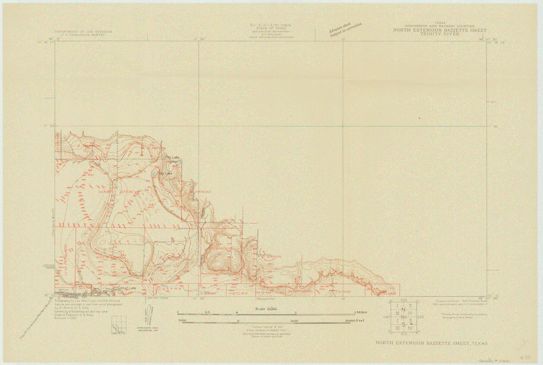
Trinity River, North Extension Bazzette Sheet
-
Map/Doc
69691
-
Collection
General Map Collection
-
Object Dates
1925 (Creation Date)
-
People and Organizations
Texas State Reclamation Department (Publisher)
Lee Morrison (Surveyor/Engineer)
H.S. Milsted (Surveyor/Engineer)
-
Counties
Henderson Navarro
-
Subjects
River Surveys Topographic
-
Height x Width
16.3 x 24.3 inches
41.4 x 61.7 cm
-
Comments
North Extension Bazzette Sheet located east of Porters Bluff Sheet, northeast of the South Extension Porters Bluff Sheet and north of the Bazzette Sheet.
Part of: General Map Collection
Wichita County Rolled Sketch 15

Print $20.00
- Digital $50.00
Wichita County Rolled Sketch 15
Size 17.0 x 37.1 inches
Map/Doc 8252
Bailey County Sketch File 12

Print $8.00
- Digital $50.00
Bailey County Sketch File 12
Size 8.3 x 12.0 inches
Map/Doc 13969
Cottle County Working Sketch 7

Print $20.00
- Digital $50.00
Cottle County Working Sketch 7
1916
Size 28.4 x 30.4 inches
Map/Doc 68317
Ellis County Boundary File 6

Print $22.00
- Digital $50.00
Ellis County Boundary File 6
Size 8.6 x 6.0 inches
Map/Doc 52992
Dimmit County Rolled Sketch 16

Print $40.00
- Digital $50.00
Dimmit County Rolled Sketch 16
1964
Size 30.5 x 48.3 inches
Map/Doc 8798
Wharton County Sketch File A4

Print $11.00
- Digital $50.00
Wharton County Sketch File A4
1904
Size 11.0 x 8.4 inches
Map/Doc 39981
Upton County Working Sketch 6

Print $20.00
- Digital $50.00
Upton County Working Sketch 6
1909
Size 17.1 x 27.0 inches
Map/Doc 69502

Webb County Sketch File 52

Print $40.00
- Digital $50.00
Webb County Sketch File 52
1939
Size 14.2 x 16.7 inches
Map/Doc 39839
Harris County Historic Topographic 33

Print $20.00
- Digital $50.00
Harris County Historic Topographic 33
1916
Size 29.3 x 22.8 inches
Map/Doc 65844
Primera parte del Mapa, que comprende la Frontera, de los Dominios del Rey, en la America Septentrional

Print $40.00
- Digital $50.00
Primera parte del Mapa, que comprende la Frontera, de los Dominios del Rey, en la America Septentrional
1769
Size 25.8 x 63.2 inches
Map/Doc 3062
Crockett County Sketch File 8 (1)

Print $6.00
- Digital $50.00
Crockett County Sketch File 8 (1)
1858
Size 9.8 x 4.6 inches
Map/Doc 19652
You may also like
Panola County, Texas

Print $20.00
- Digital $50.00
Panola County, Texas
1879
Size 18.0 x 19.4 inches
Map/Doc 654
Map of Baffin & Alazan Bays, Cayo Infiernillo in Kenedy & Kleberg Counties Showing Subdivision for Mineral Development

Print $20.00
- Digital $50.00
Map of Baffin & Alazan Bays, Cayo Infiernillo in Kenedy & Kleberg Counties Showing Subdivision for Mineral Development
1937
Size 42.4 x 40.4 inches
Map/Doc 3016
Dallam County Sketch File 13

Print $20.00
- Digital $50.00
Dallam County Sketch File 13
Size 22.2 x 20.3 inches
Map/Doc 11280
[Portions of Hansford and Hutchinson Counties]
![91136, [Portions of Hansford and Hutchinson Counties], Twichell Survey Records](https://historictexasmaps.com/wmedia_w700/maps/91136-1.tif.jpg)
Print $3.00
- Digital $50.00
[Portions of Hansford and Hutchinson Counties]
Size 11.5 x 13.5 inches
Map/Doc 91136
Coast Chart No. 211 - Padre I. and Laguna Madre Lat. 27° 12' to Lat. 26° 33' Texas

Print $20.00
- Digital $50.00
Coast Chart No. 211 - Padre I. and Laguna Madre Lat. 27° 12' to Lat. 26° 33' Texas
1890
Size 27.5 x 18.3 inches
Map/Doc 72823
[Sketch showing area around Runnels County School Land, Yates survey 34 1/2 and Runnels County School Land]
![91681, [Sketch showing area around Runnels County School Land, Yates survey 34 1/2 and Runnels County School Land], Twichell Survey Records](https://historictexasmaps.com/wmedia_w700/maps/91681-1.tif.jpg)
Print $3.00
- Digital $50.00
[Sketch showing area around Runnels County School Land, Yates survey 34 1/2 and Runnels County School Land]
Size 15.8 x 9.7 inches
Map/Doc 91681
Hamilton County Working Sketch 25

Print $20.00
- Digital $50.00
Hamilton County Working Sketch 25
1963
Size 29.5 x 26.6 inches
Map/Doc 63363
Flight Mission No. DQN-1K, Frame 42, Calhoun County

Print $20.00
- Digital $50.00
Flight Mission No. DQN-1K, Frame 42, Calhoun County
1953
Size 18.5 x 18.7 inches
Map/Doc 84142
Hardin County Sketch File 9

Print $4.00
- Digital $50.00
Hardin County Sketch File 9
1865
Size 12.4 x 8.2 inches
Map/Doc 25106
Mason County Boundary File 5a

Print $40.00
- Digital $50.00
Mason County Boundary File 5a
Size 18.0 x 32.6 inches
Map/Doc 56872
Roberts County Working Sketch 14

Print $20.00
- Digital $50.00
Roberts County Working Sketch 14
1975
Size 23.1 x 24.6 inches
Map/Doc 63540
[Aransas County, Texas]
![2083, [Aransas County, Texas], General Map Collection](https://historictexasmaps.com/wmedia_w700/maps/2083.tif.jpg)
Print $20.00
- Digital $50.00
[Aransas County, Texas]
1928
Size 37.5 x 31.3 inches
Map/Doc 2083