[William Steele Survey near Copano Bay]
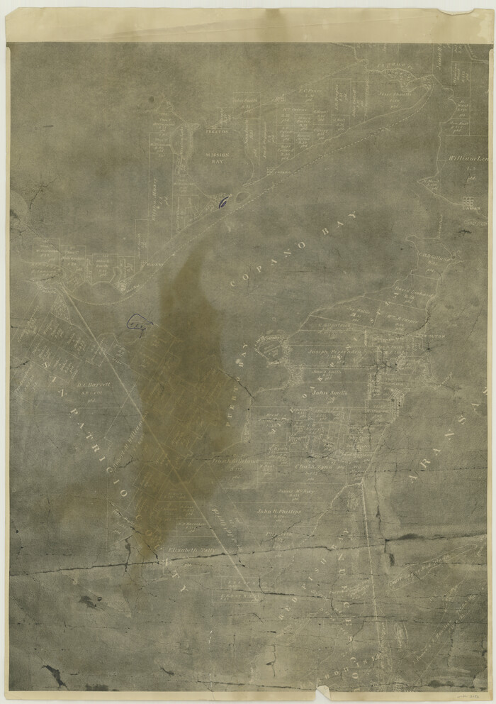
Print $20.00
- Digital $50.00
[William Steele Survey near Copano Bay]
1927
Size: 26.1 x 18.4 inches
2082
[William Steele Survey near Copano Bay]
Print $3.00
- Digital $50.00
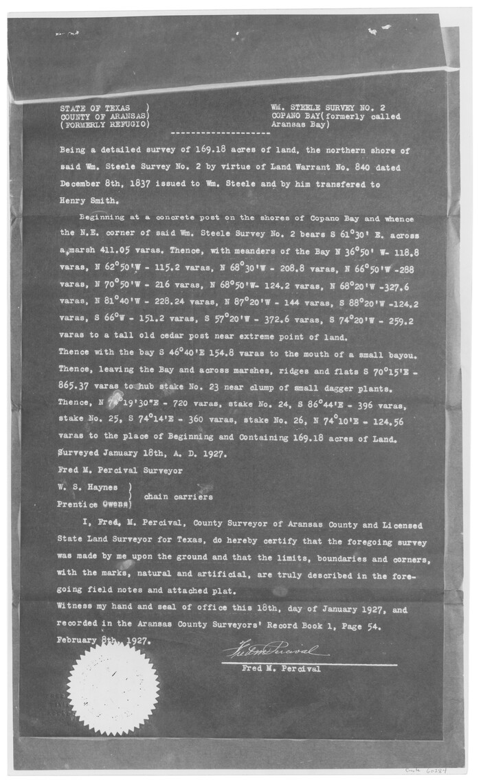
[William Steele Survey near Copano Bay]
1927
Size: 15.5 x 9.5 inches
60284
[William Steele Survey near Copano Bay]
Print $3.00
- Digital $50.00
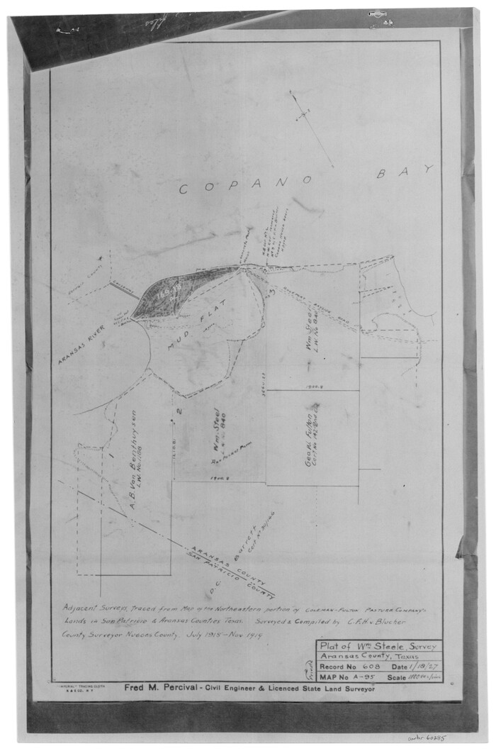
[William Steele Survey near Copano Bay]
1927
Size: 14.9 x 9.8 inches
60285
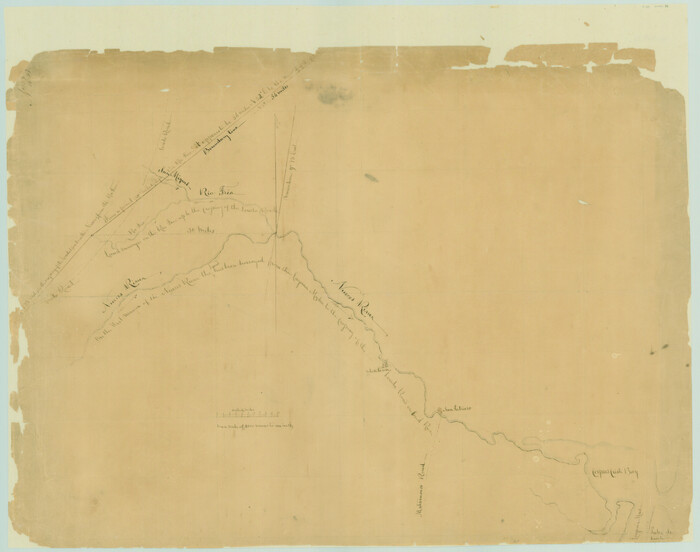
[Surveys in the Bexar and San Patricio Districts along the Nueces and Frio Rivers]
Print $20.00
- Digital $50.00
[Surveys in the Bexar and San Patricio Districts along the Nueces and Frio Rivers]
1830
Size: 21.5 x 27.3 inches
36
[Surveys in Power and Hewetson's Colony along the Aransas River, shown as Aransasu and Chiltipin Creek]
Print $20.00
- Digital $50.00
[Surveys in Power and Hewetson's Colony along the Aransas River, shown as Aransasu and Chiltipin Creek]
Size: 12.9 x 17.0 inches
31
[Surveys along the Nueces River in San Patricio County]
Print $2.00
- Digital $50.00
[Surveys along the Nueces River in San Patricio County]
1842
Size: 8.8 x 9.9 inches
69737
[Redfish Bay, Aransas Pass, and part of Mustang Island]
Print $40.00
- Digital $50.00
[Redfish Bay, Aransas Pass, and part of Mustang Island]
1930
Size: 51.0 x 46.5 inches
83009
[Note to Thos. W. Ward to make corrections for J. D. Wheeler, Survey 147 in San Patricio County, San Patricio District]
Print $2.00
- Digital $50.00
[Note to Thos. W. Ward to make corrections for J. D. Wheeler, Survey 147 in San Patricio County, San Patricio District]
1842
Size: 4.5 x 6.8 inches
69748
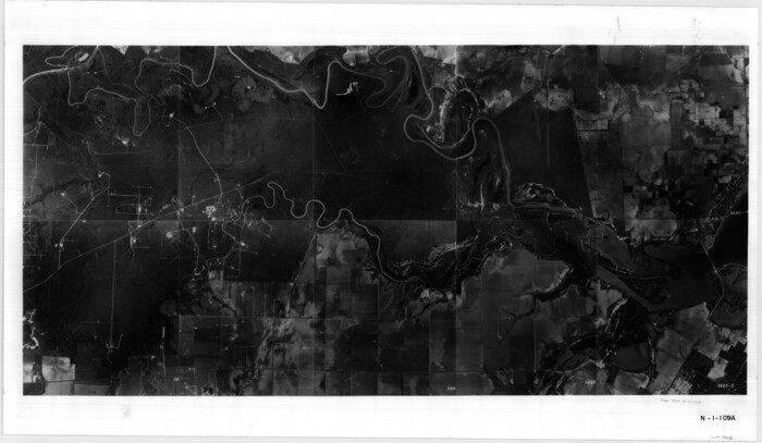
[Aerial photograph showing R. H. Welder Ranch, San Patricio County, Texas]
Print $20.00
- Digital $50.00
[Aerial photograph showing R. H. Welder Ranch, San Patricio County, Texas]
Size: 23.0 x 39.5 inches
61407
The Republic County of San Patricio. Proposed, Late Fall 1837-December 31, 1838

Print $20.00
The Republic County of San Patricio. Proposed, Late Fall 1837-December 31, 1838
2020
Size: 22.2 x 21.7 inches
96274
The Republic County of San Patricio. Proposed, Late Fall 1837

Print $20.00
The Republic County of San Patricio. Proposed, Late Fall 1837
2020
Size: 17.8 x 21.7 inches
96273
The Republic County of San Patricio. December 31, 1838

Print $20.00
The Republic County of San Patricio. December 31, 1838
2020
Size: 22.2 x 21.7 inches
96275
The Republic County of San Patricio. December 29, 1845

Print $20.00
The Republic County of San Patricio. December 29, 1845
2020
Size: 22.2 x 21.7 inches
96278
The Republic County of San Patricio. December 2, 1841

Print $20.00
The Republic County of San Patricio. December 2, 1841
2020
Size: 22.2 x 21.7 inches
96277
The Republic County of San Patricio. 1840

Print $20.00
The Republic County of San Patricio. 1840
2020
Size: 22.2 x 21.7 inches
96276
Texas, Corpus Christi Bay, Red Fish Bay to Nueces Bay

Print $40.00
- Digital $50.00
Texas, Corpus Christi Bay, Red Fish Bay to Nueces Bay
1934
Size: 31.8 x 48.3 inches
73459
Texas, Corpus Christi Bay, Nueces Bay

Print $40.00
- Digital $50.00
Texas, Corpus Christi Bay, Nueces Bay
1934
Size: 34.0 x 48.9 inches
73458
Texas, Copano Bay, Port Bay

Print $40.00
- Digital $50.00
Texas, Copano Bay, Port Bay
1934
Size: 32.9 x 48.8 inches
73432
Texas, Aransas Bay, Aransas Pass to Nine Mile Point

Print $40.00
- Digital $50.00
Texas, Aransas Bay, Aransas Pass to Nine Mile Point
1934
Size: 35.2 x 48.4 inches
73431
Texas Intracoastal Waterway, Aransas Bay to Aransas Pass

Print $20.00
- Digital $50.00
Texas Intracoastal Waterway, Aransas Bay to Aransas Pass
1957
Size: 27.5 x 39.1 inches
73436
Texas Intracoastal Waterway, Aransas Bay to Aransas Pass

Print $20.00
- Digital $50.00
Texas Intracoastal Waterway, Aransas Bay to Aransas Pass
1957
Size: 38.9 x 27.6 inches
73437
Texas Intracoastal Waterway, Aransas Bay to Aransas Pass

Print $20.00
- Digital $50.00
Texas Intracoastal Waterway, Aransas Bay to Aransas Pass
1962
Size: 26.8 x 38.7 inches
73438
Texas Intracoastal Waterway, Aransas Bay to Aransas Pass

Print $20.00
- Digital $50.00
Texas Intracoastal Waterway, Aransas Bay to Aransas Pass
1962
Size: 38.7 x 26.8 inches
73439
Soil Map - Reconnoissance Survey - South Texas Sheet

Print $20.00
- Digital $50.00
Soil Map - Reconnoissance Survey - South Texas Sheet
1909
Size: 28.6 x 37.8 inches
97267
Shores of Nueces Bay, Texas

Print $40.00
- Digital $50.00
Shores of Nueces Bay, Texas
1882
Size: 33.0 x 54.3 inches
73464
San Patricio County, Texas

Print $20.00
- Digital $50.00
San Patricio County, Texas
1879
Size: 18.1 x 22.8 inches
611
San Patricio County Working Sketch Graphic Index

Print $20.00
- Digital $50.00
San Patricio County Working Sketch Graphic Index
1939
Size: 36.6 x 47.9 inches
76692
San Patricio County Working Sketch 9

Print $40.00
- Digital $50.00
San Patricio County Working Sketch 9
1937
Size: 52.8 x 44.0 inches
63771
San Patricio County Working Sketch 8

Print $20.00
- Digital $50.00
San Patricio County Working Sketch 8
1936
Size: 26.9 x 21.5 inches
63770
San Patricio County Working Sketch 7

Print $20.00
- Digital $50.00
San Patricio County Working Sketch 7
1936
Size: 18.3 x 15.9 inches
63769
[William Steele Survey near Copano Bay]
Print $20.00
- Digital $50.00
[William Steele Survey near Copano Bay]
1927
-
Size
26.1 x 18.4 inches
-
Map/Doc
2082
-
Creation Date
1927
[William Steele Survey near Copano Bay]
Print $3.00
- Digital $50.00
[William Steele Survey near Copano Bay]
1927
-
Size
15.5 x 9.5 inches
-
Map/Doc
60284
-
Creation Date
1927
[William Steele Survey near Copano Bay]
Print $3.00
- Digital $50.00
[William Steele Survey near Copano Bay]
1927
-
Size
14.9 x 9.8 inches
-
Map/Doc
60285
-
Creation Date
1927
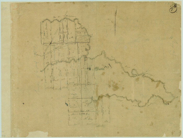
[Surveys in the Bexar and San Patricio Districts along the Nueces and Frio Rivers]
Print $20.00
- Digital $50.00
[Surveys in the Bexar and San Patricio Districts along the Nueces and Frio Rivers]
1830
-
Size
21.5 x 27.3 inches
-
Map/Doc
36
-
Creation Date
1830
[Surveys in Power and Hewetson's Colony along the Aransas River, shown as Aransasu and Chiltipin Creek]
Print $20.00
- Digital $50.00
[Surveys in Power and Hewetson's Colony along the Aransas River, shown as Aransasu and Chiltipin Creek]
-
Size
12.9 x 17.0 inches
-
Map/Doc
31
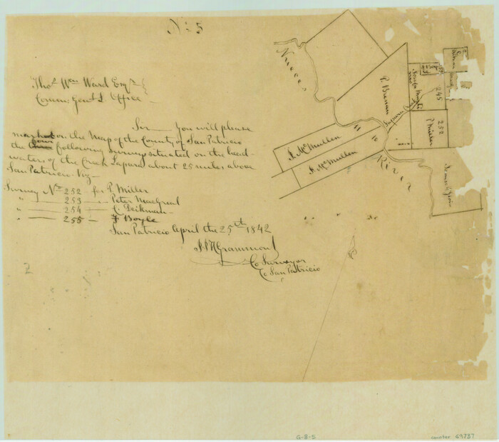
[Surveys along the Nueces River in San Patricio County]
Print $2.00
- Digital $50.00
[Surveys along the Nueces River in San Patricio County]
1842
-
Size
8.8 x 9.9 inches
-
Map/Doc
69737
-
Creation Date
1842
[Redfish Bay, Aransas Pass, and part of Mustang Island]
Print $40.00
- Digital $50.00
[Redfish Bay, Aransas Pass, and part of Mustang Island]
1930
-
Size
51.0 x 46.5 inches
-
Map/Doc
83009
-
Creation Date
1930
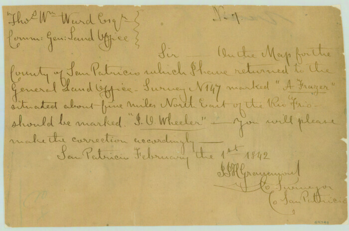
[Note to Thos. W. Ward to make corrections for J. D. Wheeler, Survey 147 in San Patricio County, San Patricio District]
Print $2.00
- Digital $50.00
[Note to Thos. W. Ward to make corrections for J. D. Wheeler, Survey 147 in San Patricio County, San Patricio District]
1842
-
Size
4.5 x 6.8 inches
-
Map/Doc
69748
-
Creation Date
1842
[Aerial photograph showing R. H. Welder Ranch, San Patricio County, Texas]
Print $20.00
- Digital $50.00
[Aerial photograph showing R. H. Welder Ranch, San Patricio County, Texas]
-
Size
23.0 x 39.5 inches
-
Map/Doc
61407
The Republic County of San Patricio. Proposed, Late Fall 1837-December 31, 1838
Print $20.00
The Republic County of San Patricio. Proposed, Late Fall 1837-December 31, 1838
2020
-
Size
22.2 x 21.7 inches
-
Map/Doc
96274
-
Creation Date
2020
The Republic County of San Patricio. Proposed, Late Fall 1837
Print $20.00
The Republic County of San Patricio. Proposed, Late Fall 1837
2020
-
Size
17.8 x 21.7 inches
-
Map/Doc
96273
-
Creation Date
2020
The Republic County of San Patricio. December 31, 1838
Print $20.00
The Republic County of San Patricio. December 31, 1838
2020
-
Size
22.2 x 21.7 inches
-
Map/Doc
96275
-
Creation Date
2020
The Republic County of San Patricio. December 29, 1845
Print $20.00
The Republic County of San Patricio. December 29, 1845
2020
-
Size
22.2 x 21.7 inches
-
Map/Doc
96278
-
Creation Date
2020
The Republic County of San Patricio. December 2, 1841
Print $20.00
The Republic County of San Patricio. December 2, 1841
2020
-
Size
22.2 x 21.7 inches
-
Map/Doc
96277
-
Creation Date
2020
The Republic County of San Patricio. 1840
Print $20.00
The Republic County of San Patricio. 1840
2020
-
Size
22.2 x 21.7 inches
-
Map/Doc
96276
-
Creation Date
2020
Texas, Corpus Christi Bay, Red Fish Bay to Nueces Bay
Print $40.00
- Digital $50.00
Texas, Corpus Christi Bay, Red Fish Bay to Nueces Bay
1934
-
Size
31.8 x 48.3 inches
-
Map/Doc
73459
-
Creation Date
1934
Texas, Corpus Christi Bay, Nueces Bay
Print $40.00
- Digital $50.00
Texas, Corpus Christi Bay, Nueces Bay
1934
-
Size
34.0 x 48.9 inches
-
Map/Doc
73458
-
Creation Date
1934
Texas, Copano Bay, Port Bay
Print $40.00
- Digital $50.00
Texas, Copano Bay, Port Bay
1934
-
Size
32.9 x 48.8 inches
-
Map/Doc
73432
-
Creation Date
1934
Texas, Aransas Bay, Aransas Pass to Nine Mile Point
Print $40.00
- Digital $50.00
Texas, Aransas Bay, Aransas Pass to Nine Mile Point
1934
-
Size
35.2 x 48.4 inches
-
Map/Doc
73431
-
Creation Date
1934
Texas Intracoastal Waterway, Aransas Bay to Aransas Pass
Print $20.00
- Digital $50.00
Texas Intracoastal Waterway, Aransas Bay to Aransas Pass
1957
-
Size
27.5 x 39.1 inches
-
Map/Doc
73436
-
Creation Date
1957
Texas Intracoastal Waterway, Aransas Bay to Aransas Pass
Print $20.00
- Digital $50.00
Texas Intracoastal Waterway, Aransas Bay to Aransas Pass
1957
-
Size
38.9 x 27.6 inches
-
Map/Doc
73437
-
Creation Date
1957
Texas Intracoastal Waterway, Aransas Bay to Aransas Pass
Print $20.00
- Digital $50.00
Texas Intracoastal Waterway, Aransas Bay to Aransas Pass
1962
-
Size
26.8 x 38.7 inches
-
Map/Doc
73438
-
Creation Date
1962
Texas Intracoastal Waterway, Aransas Bay to Aransas Pass
Print $20.00
- Digital $50.00
Texas Intracoastal Waterway, Aransas Bay to Aransas Pass
1962
-
Size
38.7 x 26.8 inches
-
Map/Doc
73439
-
Creation Date
1962
Soil Map - Reconnoissance Survey - South Texas Sheet
Print $20.00
- Digital $50.00
Soil Map - Reconnoissance Survey - South Texas Sheet
1909
-
Size
28.6 x 37.8 inches
-
Map/Doc
97267
-
Creation Date
1909
Shores of Nueces Bay, Texas
Print $40.00
- Digital $50.00
Shores of Nueces Bay, Texas
1882
-
Size
33.0 x 54.3 inches
-
Map/Doc
73464
-
Creation Date
1882
San Patricio County, Texas
Print $20.00
- Digital $50.00
San Patricio County, Texas
1879
-
Size
18.1 x 22.8 inches
-
Map/Doc
611
-
Creation Date
1879
San Patricio County Working Sketch Graphic Index
Print $20.00
- Digital $50.00
San Patricio County Working Sketch Graphic Index
1939
-
Size
36.6 x 47.9 inches
-
Map/Doc
76692
-
Creation Date
1939
San Patricio County Working Sketch 9
Print $40.00
- Digital $50.00
San Patricio County Working Sketch 9
1937
-
Size
52.8 x 44.0 inches
-
Map/Doc
63771
-
Creation Date
1937
San Patricio County Working Sketch 8
Print $20.00
- Digital $50.00
San Patricio County Working Sketch 8
1936
-
Size
26.9 x 21.5 inches
-
Map/Doc
63770
-
Creation Date
1936
San Patricio County Working Sketch 7
Print $20.00
- Digital $50.00
San Patricio County Working Sketch 7
1936
-
Size
18.3 x 15.9 inches
-
Map/Doc
63769
-
Creation Date
1936