San Patricio County Rolled Sketch 51

Print $40.00
- Digital $50.00
San Patricio County Rolled Sketch 51
1988
Size: 41.8 x 54.6 inches
10635
Aransas County Sketch File 9

Print $40.00
- Digital $50.00
Aransas County Sketch File 9
Size: 17.5 x 19.8 inches
10819
Aransas County Sketch File 17

Print $40.00
- Digital $50.00
Aransas County Sketch File 17
Size: 28.4 x 16.7 inches
10822
San Patricio County Sketch File 4

Print $40.00
- Digital $50.00
San Patricio County Sketch File 4
Size: 16.9 x 30.5 inches
12283
San Patricio County Sketch File 17

Print $20.00
San Patricio County Sketch File 17
1873
Size: 12.0 x 19.0 inches
12284
San Patricio County Sketch File 22

Print $20.00
San Patricio County Sketch File 22
1918
Size: 22.2 x 16.9 inches
12285
San Patricio County Sketch File 23

Print $20.00
San Patricio County Sketch File 23
1910
Size: 22.9 x 12.9 inches
12286
San Patricio County Sketch File 32

Print $20.00
- Digital $50.00
San Patricio County Sketch File 32
Size: 13.7 x 30.3 inches
12287
San Patricio County Sketch File 33

Print $20.00
- Digital $50.00
San Patricio County Sketch File 33
1946
Size: 15.5 x 31.0 inches
12288
Aransas County Sketch File 6

Print $4.00
- Digital $50.00
Aransas County Sketch File 6
Size: 8.2 x 10.7 inches
13110
Aransas County Sketch File 26

Print $28.00
- Digital $50.00
Aransas County Sketch File 26
1896
Size: 5.2 x 4.7 inches
13219
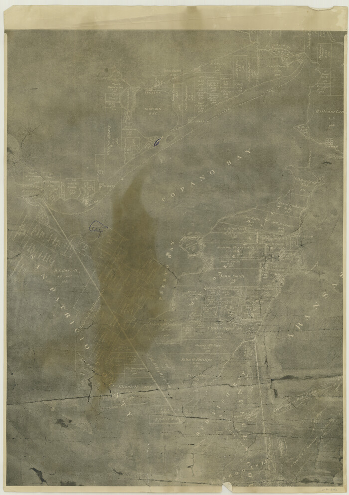
Map of San Patricio County

Print $40.00
- Digital $50.00
Map of San Patricio County
1896
Size: 29.1 x 48.7 inches
1336
Bee County Sketch File 14

Print $40.00
- Digital $50.00
Bee County Sketch File 14
1878
Size: 14.5 x 12.5 inches
14297
Map of the District of San Patricio and Nueces

Print $40.00
- Digital $50.00
Map of the District of San Patricio and Nueces
Size: 93.8 x 67.5 inches
1955
Map of San Patricio District

Print $40.00
- Digital $50.00
Map of San Patricio District
1870
Size: 43.8 x 51.4 inches
1987
[William Steele Survey near Copano Bay]
Print $20.00
- Digital $50.00
[William Steele Survey near Copano Bay]
1927
Size: 26.1 x 18.4 inches
2082
Hydrography Survey H-6395 Off Coast of Texas, Aransas Pass to Corpus Christi Pass in the Gulf of Mexico

Print $40.00
- Digital $50.00
Hydrography Survey H-6395 Off Coast of Texas, Aransas Pass to Corpus Christi Pass in the Gulf of Mexico
1938
Size: 56.1 x 33.6 inches
2696
Hydrographic Survey H-6395 of Outer Coast of Padre Island; Gulf of Mexico

Print $40.00
- Digital $50.00
Hydrographic Survey H-6395 of Outer Coast of Padre Island; Gulf of Mexico
1938
Size: 55.1 x 33.3 inches
2697
Live Oak County Sketch File 1

Print $4.00
- Digital $50.00
Live Oak County Sketch File 1
1856
Size: 11.5 x 7.8 inches
30251
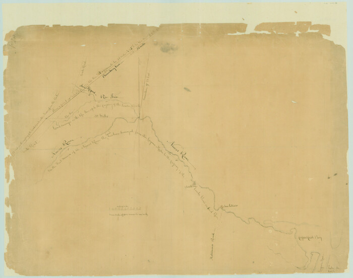
[Surveys in Power and Hewetson's Colony along the Aransas River, shown as Aransasu and Chiltipin Creek]
Print $20.00
- Digital $50.00
[Surveys in Power and Hewetson's Colony along the Aransas River, shown as Aransasu and Chiltipin Creek]
Size: 12.9 x 17.0 inches
31
Nueces County Sketch File 7

Print $7.00
- Digital $50.00
Nueces County Sketch File 7
1849
Size: 11.3 x 9.3 inches
32509
Nueces County Sketch File 43

Print $24.00
- Digital $50.00
Nueces County Sketch File 43
1952
Size: 14.2 x 8.6 inches
32635
Nueces County Sketch File 50

Print $463.00
- Digital $50.00
Nueces County Sketch File 50
Size: 9.6 x 6.2 inches
32673
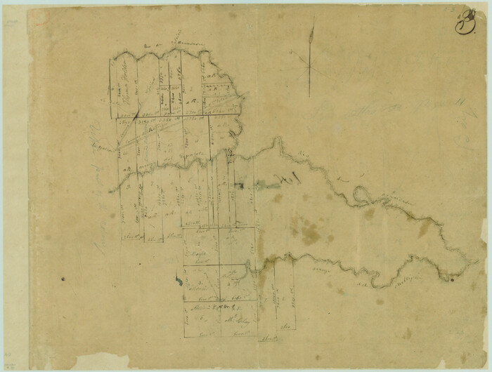
[Surveys in the Bexar and San Patricio Districts along the Nueces and Frio Rivers]
Print $20.00
- Digital $50.00
[Surveys in the Bexar and San Patricio Districts along the Nueces and Frio Rivers]
1830
Size: 21.5 x 27.3 inches
36
San Patricio County Sketch File 3

Print $10.00
- Digital $50.00
San Patricio County Sketch File 3
1850
Size: 11.0 x 15.6 inches
36029
San Patricio County Sketch File 5a

Print $4.00
- Digital $50.00
San Patricio County Sketch File 5a
Size: 5.5 x 8.6 inches
36033
San Patricio County Sketch File 6

Print $4.00
- Digital $50.00
San Patricio County Sketch File 6
Size: 8.7 x 5.5 inches
36035
San Patricio County Sketch File 9

Print $2.00
- Digital $50.00
San Patricio County Sketch File 9
1846
Size: 8.3 x 8.7 inches
36039
San Patricio County Sketch File 10

Print $8.00
San Patricio County Sketch File 10
1847
Size: 13.3 x 8.4 inches
36040
San Patricio County Rolled Sketch 51
Print $40.00
- Digital $50.00
San Patricio County Rolled Sketch 51
1988
-
Size
41.8 x 54.6 inches
-
Map/Doc
10635
-
Creation Date
1988
Aransas County Sketch File 9
Print $40.00
- Digital $50.00
Aransas County Sketch File 9
-
Size
17.5 x 19.8 inches
-
Map/Doc
10819
Aransas County Sketch File 17
Print $40.00
- Digital $50.00
Aransas County Sketch File 17
-
Size
28.4 x 16.7 inches
-
Map/Doc
10822
San Patricio County Sketch File 4
Print $40.00
- Digital $50.00
San Patricio County Sketch File 4
-
Size
16.9 x 30.5 inches
-
Map/Doc
12283
San Patricio County Sketch File 17
Print $20.00
San Patricio County Sketch File 17
1873
-
Size
12.0 x 19.0 inches
-
Map/Doc
12284
-
Creation Date
1873
San Patricio County Sketch File 22
Print $20.00
San Patricio County Sketch File 22
1918
-
Size
22.2 x 16.9 inches
-
Map/Doc
12285
-
Creation Date
1918
San Patricio County Sketch File 23
Print $20.00
San Patricio County Sketch File 23
1910
-
Size
22.9 x 12.9 inches
-
Map/Doc
12286
-
Creation Date
1910
San Patricio County Sketch File 32
Print $20.00
- Digital $50.00
San Patricio County Sketch File 32
-
Size
13.7 x 30.3 inches
-
Map/Doc
12287
San Patricio County Sketch File 33
Print $20.00
- Digital $50.00
San Patricio County Sketch File 33
1946
-
Size
15.5 x 31.0 inches
-
Map/Doc
12288
-
Creation Date
1946
Aransas County Sketch File 6
Print $4.00
- Digital $50.00
Aransas County Sketch File 6
-
Size
8.2 x 10.7 inches
-
Map/Doc
13110
Aransas County Sketch File 26
Print $28.00
- Digital $50.00
Aransas County Sketch File 26
1896
-
Size
5.2 x 4.7 inches
-
Map/Doc
13219
-
Creation Date
1896
Map of San Patricio County
Print $40.00
- Digital $50.00
Map of San Patricio County
1896
-
Size
29.1 x 48.7 inches
-
Map/Doc
1336
-
Creation Date
1896
Bee County Sketch File 14
Print $40.00
- Digital $50.00
Bee County Sketch File 14
1878
-
Size
14.5 x 12.5 inches
-
Map/Doc
14297
-
Creation Date
1878
Map of the District of San Patricio and Nueces
Print $40.00
- Digital $50.00
Map of the District of San Patricio and Nueces
-
Size
93.8 x 67.5 inches
-
Map/Doc
1955
Map of San Patricio District
Print $40.00
- Digital $50.00
Map of San Patricio District
1870
-
Size
43.8 x 51.4 inches
-
Map/Doc
1987
-
Creation Date
1870
[William Steele Survey near Copano Bay]
Print $20.00
- Digital $50.00
[William Steele Survey near Copano Bay]
1927
-
Size
26.1 x 18.4 inches
-
Map/Doc
2082
-
Creation Date
1927
Refugio District

Print $20.00
- Digital $50.00
Refugio District
1855
-
Size
30.7 x 34.7 inches
-
Map/Doc
2139
-
Creation Date
1855
Hydrography Survey H-6395 Off Coast of Texas, Aransas Pass to Corpus Christi Pass in the Gulf of Mexico
Print $40.00
- Digital $50.00
Hydrography Survey H-6395 Off Coast of Texas, Aransas Pass to Corpus Christi Pass in the Gulf of Mexico
1938
-
Size
56.1 x 33.6 inches
-
Map/Doc
2696
-
Creation Date
1938
Hydrographic Survey H-6395 of Outer Coast of Padre Island; Gulf of Mexico
Print $40.00
- Digital $50.00
Hydrographic Survey H-6395 of Outer Coast of Padre Island; Gulf of Mexico
1938
-
Size
55.1 x 33.3 inches
-
Map/Doc
2697
-
Creation Date
1938
Live Oak County Sketch File 1
Print $4.00
- Digital $50.00
Live Oak County Sketch File 1
1856
-
Size
11.5 x 7.8 inches
-
Map/Doc
30251
-
Creation Date
1856
[Surveys in Power and Hewetson's Colony along the Aransas River, shown as Aransasu and Chiltipin Creek]
Print $20.00
- Digital $50.00
[Surveys in Power and Hewetson's Colony along the Aransas River, shown as Aransasu and Chiltipin Creek]
-
Size
12.9 x 17.0 inches
-
Map/Doc
31
Nueces County Sketch File 7
Print $7.00
- Digital $50.00
Nueces County Sketch File 7
1849
-
Size
11.3 x 9.3 inches
-
Map/Doc
32509
-
Creation Date
1849
Nueces County Sketch File 43
Print $24.00
- Digital $50.00
Nueces County Sketch File 43
1952
-
Size
14.2 x 8.6 inches
-
Map/Doc
32635
-
Creation Date
1952
Nueces County Sketch File 50
Print $463.00
- Digital $50.00
Nueces County Sketch File 50
-
Size
9.6 x 6.2 inches
-
Map/Doc
32673
[Surveys in the Bexar and San Patricio Districts along the Nueces and Frio Rivers]
Print $20.00
- Digital $50.00
[Surveys in the Bexar and San Patricio Districts along the Nueces and Frio Rivers]
1830
-
Size
21.5 x 27.3 inches
-
Map/Doc
36
-
Creation Date
1830
San Patricio County Sketch File 3
Print $10.00
- Digital $50.00
San Patricio County Sketch File 3
1850
-
Size
11.0 x 15.6 inches
-
Map/Doc
36029
-
Creation Date
1850
San Patricio County Sketch File 5a
Print $4.00
- Digital $50.00
San Patricio County Sketch File 5a
-
Size
5.5 x 8.6 inches
-
Map/Doc
36033
San Patricio County Sketch File 6
Print $4.00
- Digital $50.00
San Patricio County Sketch File 6
-
Size
8.7 x 5.5 inches
-
Map/Doc
36035
San Patricio County Sketch File 9
Print $2.00
- Digital $50.00
San Patricio County Sketch File 9
1846
-
Size
8.3 x 8.7 inches
-
Map/Doc
36039
-
Creation Date
1846
San Patricio County Sketch File 10
Print $8.00
San Patricio County Sketch File 10
1847
-
Size
13.3 x 8.4 inches
-
Map/Doc
36040
-
Creation Date
1847