San Patricio County Sketch File 6
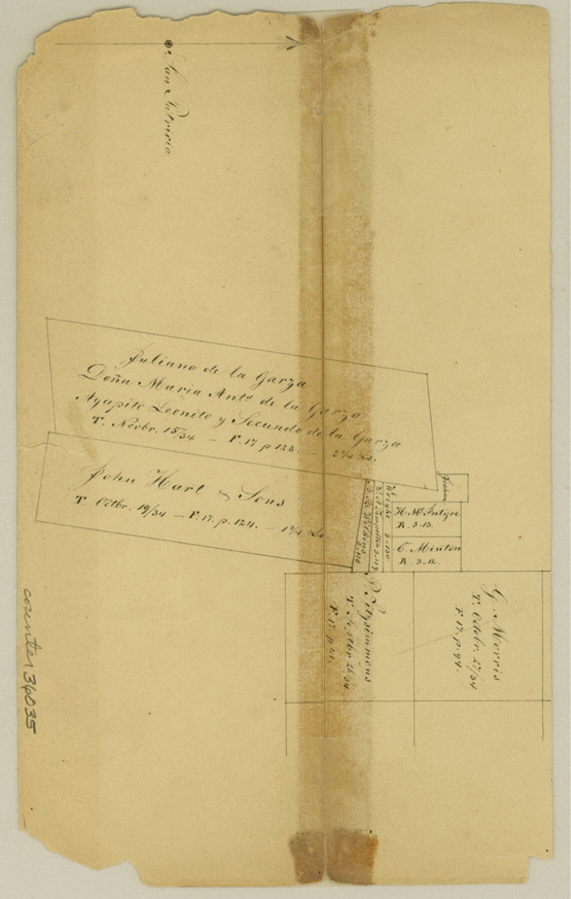
[Sketch of area around the large de la Garza and Hart surveys north of the Nueces River in the southwest part of the county]
-
Map/Doc
36035
-
Collection
General Map Collection
-
Counties
San Patricio
-
Subjects
Surveying Sketch File
-
Height x Width
8.7 x 5.5 inches
22.1 x 14.0 cm
-
Medium
paper, manuscript
-
Features
San Patricio
Nueces River
Part of: General Map Collection
Hemphill County Working Sketch 37

Print $20.00
- Digital $50.00
Hemphill County Working Sketch 37
1981
Size 28.6 x 24.0 inches
Map/Doc 66132
Brewster County Sketch File N-10

Print $14.00
- Digital $50.00
Brewster County Sketch File N-10
1922
Size 11.2 x 8.7 inches
Map/Doc 15616
Montague County Boundary File 1

Print $32.00
- Digital $50.00
Montague County Boundary File 1
Size 12.8 x 8.1 inches
Map/Doc 57399
Aransas County Rolled Sketch 24A

Print $20.00
- Digital $50.00
Aransas County Rolled Sketch 24A
Size 15.8 x 24.1 inches
Map/Doc 5062
Gaines County Working Sketch 16

Print $20.00
- Digital $50.00
Gaines County Working Sketch 16
1959
Size 42.4 x 37.3 inches
Map/Doc 69316
Montague County Working Sketch 40

Print $20.00
- Digital $50.00
Montague County Working Sketch 40
1995
Size 20.6 x 17.5 inches
Map/Doc 71106
Tom Green County Sketch File 60

Print $20.00
- Digital $50.00
Tom Green County Sketch File 60
1888
Size 28.4 x 25.9 inches
Map/Doc 12444
Menard County Working Sketch 8

Print $20.00
- Digital $50.00
Menard County Working Sketch 8
1928
Size 19.2 x 15.7 inches
Map/Doc 70955
Johnson County Sketch File 14a

Print $6.00
- Digital $50.00
Johnson County Sketch File 14a
1862
Size 8.0 x 11.1 inches
Map/Doc 28452
Chambers County Working Sketch 1

Print $20.00
- Digital $50.00
Chambers County Working Sketch 1
1895
Size 29.4 x 24.9 inches
Map/Doc 67984
Bandera County Working Sketch 46

Print $20.00
- Digital $50.00
Bandera County Working Sketch 46
1981
Size 28.0 x 37.4 inches
Map/Doc 67642
Travis County Sketch File 24

Print $4.00
- Digital $50.00
Travis County Sketch File 24
1876
Size 8.1 x 15.4 inches
Map/Doc 38332
You may also like
Bee County Sketch File Y

Print $4.00
- Digital $50.00
Bee County Sketch File Y
Size 8.8 x 5.4 inches
Map/Doc 14255
G. C. & S. F. Ry., San Saba Branch Right of Way Map, Melvin to Eden

Print $40.00
- Digital $50.00
G. C. & S. F. Ry., San Saba Branch Right of Way Map, Melvin to Eden
1916
Size 37.6 x 63.1 inches
Map/Doc 61417
Smith County Working Sketch 9

Print $40.00
- Digital $50.00
Smith County Working Sketch 9
1947
Size 48.8 x 44.2 inches
Map/Doc 63894
A Topographical Map of the Government Tract adjoining the City of Austin

Print $20.00
- Digital $50.00
A Topographical Map of the Government Tract adjoining the City of Austin
1840
Size 41.9 x 37.8 inches
Map/Doc 2180
Fisher County Sketch File 1

Print $20.00
- Digital $50.00
Fisher County Sketch File 1
Size 43.5 x 18.3 inches
Map/Doc 10448
Plat of Surveys in Hidalgo Co.

Print $20.00
- Digital $50.00
Plat of Surveys in Hidalgo Co.
Size 18.2 x 9.3 inches
Map/Doc 405

Panola County Working Sketch 30

Print $20.00
- Digital $50.00
Panola County Working Sketch 30
1981
Map/Doc 71439
Calcasieu Pass to Sabine Pass

Print $20.00
- Digital $50.00
Calcasieu Pass to Sabine Pass
1992
Size 44.5 x 35.8 inches
Map/Doc 69815
[Bastrop District]
![16941, [Bastrop District], General Map Collection](https://historictexasmaps.com/wmedia_w700/maps/16941-1.tif.jpg)
Print $40.00
- Digital $50.00
[Bastrop District]
1838
Size 67.3 x 44.2 inches
Map/Doc 16941
Flight Mission No. DQN-1K, Frame 66, Calhoun County

Print $20.00
- Digital $50.00
Flight Mission No. DQN-1K, Frame 66, Calhoun County
1953
Size 18.7 x 22.3 inches
Map/Doc 84153
Jack County Working Sketch 10

Print $20.00
- Digital $50.00
Jack County Working Sketch 10
1955
Size 24.4 x 18.6 inches
Map/Doc 66436