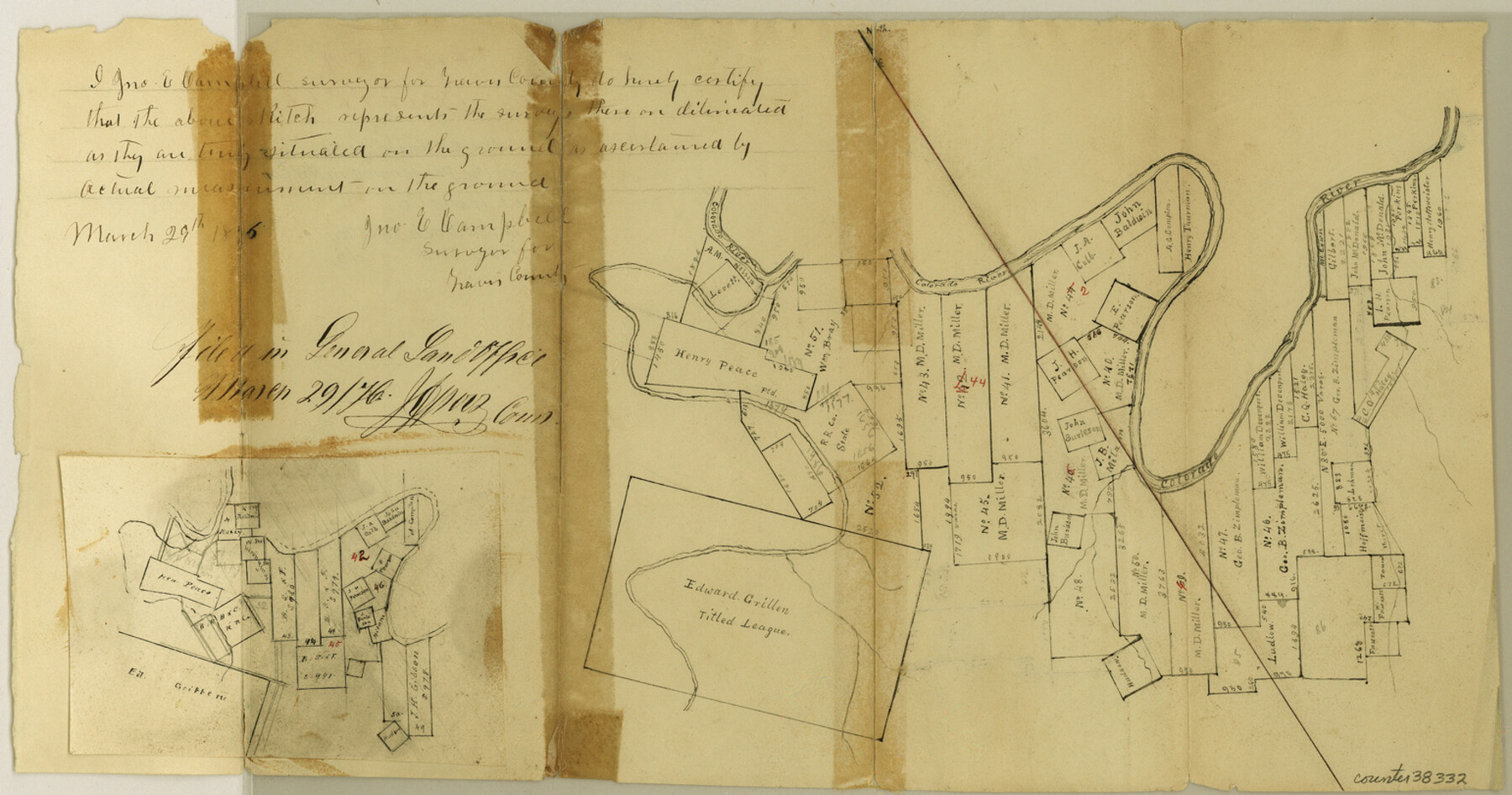
Travis County Sketch File 24
[Sketch of surveys south of the Colorado River and east of the Pedernales River in the western part of the county]
-
Map/Doc
38332
-
Collection
General Map Collection
-
Object Dates
3/29/1876 (Creation Date)
3/29/1876 (File Date)
-
People and Organizations
Jno. E. Campbell (Surveyor/Engineer)
-
Counties
Travis
-
Subjects
Surveying Sketch File
-
Height x Width
8.1 x 15.4 inches
20.6 x 39.1 cm
-
Medium
paper, manuscript
-
Features
Colorado River
[Pedernales River]
Part of: General Map Collection
South Part Crockett County

Print $40.00
- Digital $50.00
South Part Crockett County
1977
Size 39.7 x 51.4 inches
Map/Doc 73122
Denton County Sketch File 1

Print $2.00
- Digital $50.00
Denton County Sketch File 1
Size 8.4 x 10.6 inches
Map/Doc 20681

Reagan County Rolled Sketch 32

Print $20.00
- Digital $50.00
Reagan County Rolled Sketch 32
Size 46.3 x 38.5 inches
Map/Doc 9827
Mitchell County Boundary File 1

Print $38.00
- Digital $50.00
Mitchell County Boundary File 1
Size 9.1 x 8.4 inches
Map/Doc 57334
Hamilton County Working Sketch 24

Print $20.00
- Digital $50.00
Hamilton County Working Sketch 24
1979
Size 34.7 x 33.6 inches
Map/Doc 63362
Real County Working Sketch 87

Print $20.00
- Digital $50.00
Real County Working Sketch 87
1988
Size 30.9 x 29.6 inches
Map/Doc 71979
Coleman County Working Sketch 6

Print $20.00
- Digital $50.00
Coleman County Working Sketch 6
1939
Size 19.1 x 21.8 inches
Map/Doc 68072
Township No. 1 North Range No. 27 West Indian Meridian

Print $20.00
- Digital $50.00
Township No. 1 North Range No. 27 West Indian Meridian
1875
Size 19.3 x 24.6 inches
Map/Doc 75170
Terrell County Rolled Sketch 49

Print $20.00
- Digital $50.00
Terrell County Rolled Sketch 49
1962
Size 17.3 x 24.1 inches
Map/Doc 7951
Newton County Rolled Sketch 28

Print $373.00
- Digital $50.00
Newton County Rolled Sketch 28
1938
Size 10.3 x 15.4 inches
Map/Doc 47418
Comanche County

Print $20.00
- Digital $50.00
Comanche County
1896
Size 39.4 x 44.2 inches
Map/Doc 4734
You may also like
[Leagues 11 and 22]
![91111, [Leagues 11 and 22], Twichell Survey Records](https://historictexasmaps.com/wmedia_w700/maps/91111-1.tif.jpg)
Print $20.00
- Digital $50.00
[Leagues 11 and 22]
1925
Size 14.0 x 13.6 inches
Map/Doc 91111
Clay County Sketch File 11

Print $4.00
- Digital $50.00
Clay County Sketch File 11
1870
Size 10.1 x 7.9 inches
Map/Doc 18408
Brewster County Sketch File D

Print $4.00
- Digital $50.00
Brewster County Sketch File D
1938
Size 14.5 x 8.8 inches
Map/Doc 15738
Eastland County Working Sketch 12

Print $20.00
- Digital $50.00
Eastland County Working Sketch 12
1919
Size 23.8 x 21.1 inches
Map/Doc 68793
D No. 3 - Sketch of Ocracoke Inlet, North Carolina

Print $20.00
- Digital $50.00
D No. 3 - Sketch of Ocracoke Inlet, North Carolina
1852
Size 17.0 x 16.1 inches
Map/Doc 97210
Map and Profile No. 1 from the Red River to the Rio Grande; from explorations and surveys made under the direction of the Hon. Jefferson Davis, Secretary of War by Captain John Pope, Corps. Topl Engrs.

Print $40.00
- Digital $50.00
Map and Profile No. 1 from the Red River to the Rio Grande; from explorations and surveys made under the direction of the Hon. Jefferson Davis, Secretary of War by Captain John Pope, Corps. Topl Engrs.
Size 30.2 x 59.9 inches
Map/Doc 95176
Blanco County Sketch File 33

Print $4.00
- Digital $50.00
Blanco County Sketch File 33
Size 7.9 x 7.0 inches
Map/Doc 14635
Houston Ship Channel

Print $20.00
- Digital $50.00
Houston Ship Channel
1926
Size 32.9 x 38.3 inches
Map/Doc 69893
Hunt County Boundary File 7

Print $14.00
- Digital $50.00
Hunt County Boundary File 7
Size 14.1 x 8.7 inches
Map/Doc 55228
Ward County Rolled Sketch 24F

Print $40.00
- Digital $50.00
Ward County Rolled Sketch 24F
1967
Size 43.0 x 72.4 inches
Map/Doc 10117
Irion County Working Sketch 9

Print $20.00
- Digital $50.00
Irion County Working Sketch 9
1941
Size 13.6 x 17.2 inches
Map/Doc 66418
L'Amerique Meridionale, et Septentrionale Dressee selon les derniers Relations et suivant les Nouvelles Decouvertes

Print $20.00
- Digital $50.00
L'Amerique Meridionale, et Septentrionale Dressee selon les derniers Relations et suivant les Nouvelles Decouvertes
1726
Size 18.9 x 24.1 inches
Map/Doc 95134