[Throckmorton County]
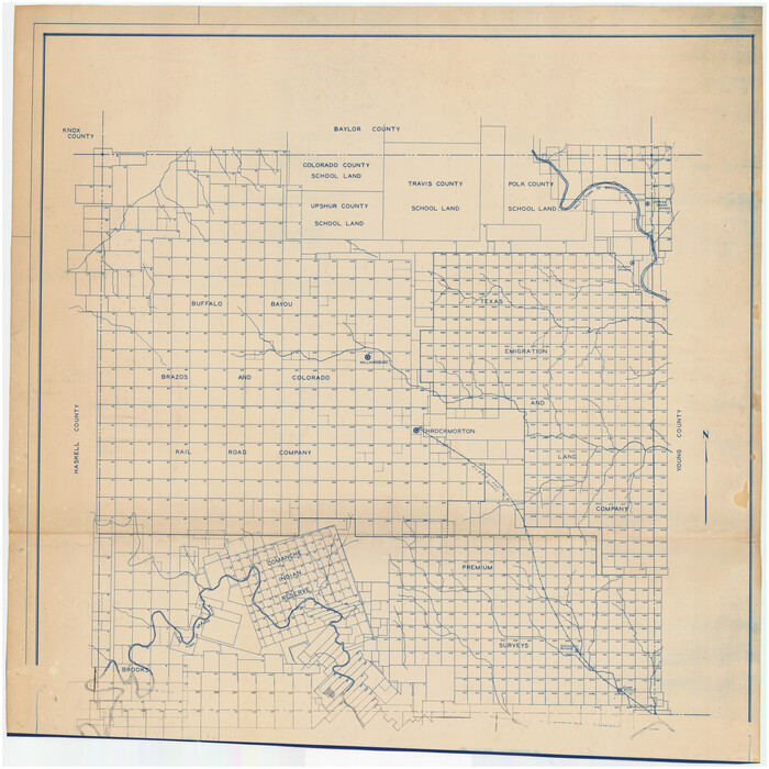
Print $20.00
- Digital $50.00
[Throckmorton County]
Size: 39.7 x 40.0 inches
89875
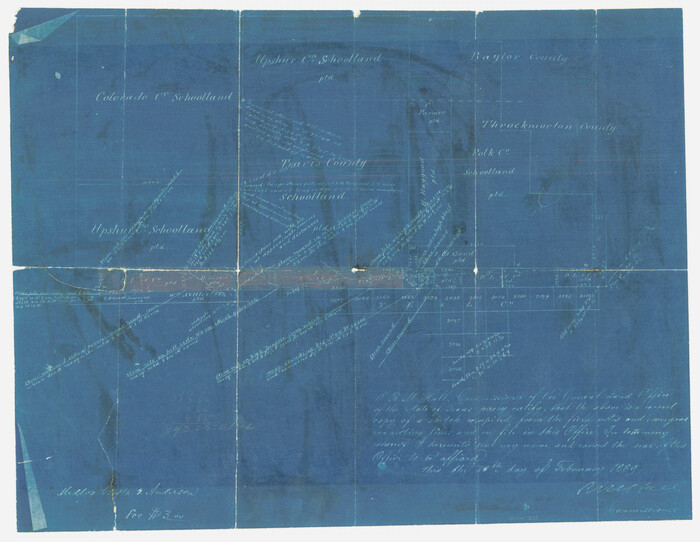
[Sketch showing County School Land surveys in Throckmorton and Baylor Counties, Texas]
Print $20.00
- Digital $50.00
[Sketch showing County School Land surveys in Throckmorton and Baylor Counties, Texas]
Size: 27.7 x 39.4 inches
75800
[Sketch showing County School Land Surveys in Throckmorton Counties, Texas]
Print $20.00
- Digital $50.00
[Sketch showing County School Land Surveys in Throckmorton Counties, Texas]
1889
Size: 15.9 x 20.2 inches
628
[Plat Showing Colorado, Upshur & Travis County School Land and Surrounding Area in Baylor & Throckmorton Counties, Texas]
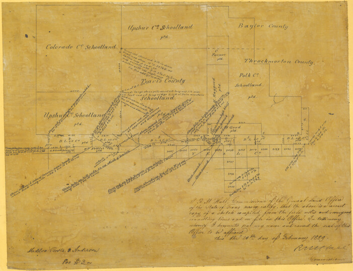
Print $20.00
- Digital $50.00
[Plat Showing Colorado, Upshur & Travis County School Land and Surrounding Area in Baylor & Throckmorton Counties, Texas]
1889
Size: 15.8 x 20.5 inches
75790
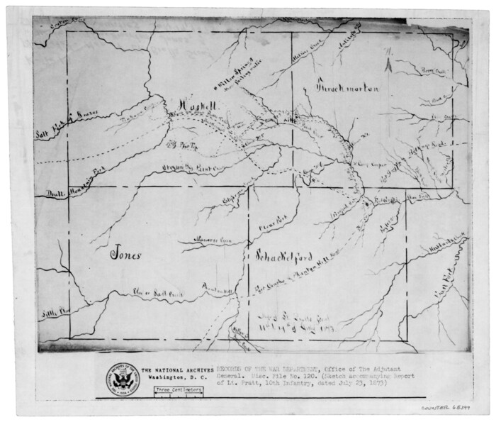
[Map of Lt. Brulls scout in Haskell, Throckmorton, Jones and Shackelford Counties]
Print $3.00
- Digital $50.00
[Map of Lt. Brulls scout in Haskell, Throckmorton, Jones and Shackelford Counties]
1873
Size: 10.1 x 11.9 inches
65399
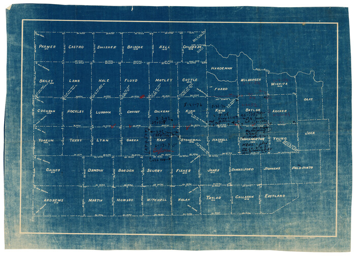
[Map of Counties South of Panhandle from Parmer to Childress in North to Andrews to Eastland in the South]
Print $3.00
- Digital $50.00
[Map of Counties South of Panhandle from Parmer to Childress in North to Andrews to Eastland in the South]
Size: 14.9 x 10.7 inches
92098
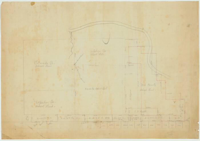
Working Sketch in Baylor and Throckmorton Cos.

Print $20.00
- Digital $50.00
Working Sketch in Baylor and Throckmorton Cos.
1890
Size: 24.2 x 20.8 inches
75771
Throckmorton County, Texas

Print $20.00
- Digital $50.00
Throckmorton County, Texas
1880
Size: 28.8 x 22.5 inches
627
Throckmorton County Working Sketch Graphic Index

Print $20.00
- Digital $50.00
Throckmorton County Working Sketch Graphic Index
1943
Size: 44.6 x 36.3 inches
76713
Throckmorton County Working Sketch 9

Print $20.00
- Digital $50.00
Throckmorton County Working Sketch 9
1963
Size: 25.2 x 35.8 inches
62118
Throckmorton County Working Sketch 8

Print $20.00
- Digital $50.00
Throckmorton County Working Sketch 8
1958
Size: 21.6 x 30.4 inches
62117
Throckmorton County Working Sketch 7

Print $20.00
- Digital $50.00
Throckmorton County Working Sketch 7
1956
Size: 25.8 x 32.0 inches
62116
Throckmorton County Working Sketch 6

Print $20.00
- Digital $50.00
Throckmorton County Working Sketch 6
1952
Size: 24.7 x 21.7 inches
62115
Throckmorton County Working Sketch 5

Print $20.00
- Digital $50.00
Throckmorton County Working Sketch 5
1927
Size: 31.8 x 24.4 inches
62114
Throckmorton County Working Sketch 4

Print $20.00
- Digital $50.00
Throckmorton County Working Sketch 4
1949
Size: 25.0 x 24.9 inches
62113
Throckmorton County Working Sketch 3

Print $20.00
- Digital $50.00
Throckmorton County Working Sketch 3
1924
Size: 19.8 x 23.8 inches
62112
Throckmorton County Working Sketch 2

Print $20.00
- Digital $50.00
Throckmorton County Working Sketch 2
1919
Size: 20.9 x 16.9 inches
62111
Throckmorton County Working Sketch 12

Print $20.00
- Digital $50.00
Throckmorton County Working Sketch 12
2019
Size: 24.7 x 36.7 inches
95719
Throckmorton County Working Sketch 11

Print $20.00
- Digital $50.00
Throckmorton County Working Sketch 11
1994
Size: 43.9 x 34.1 inches
62120
Throckmorton County Working Sketch 10

Print $20.00
- Digital $50.00
Throckmorton County Working Sketch 10
1986
Size: 22.8 x 36.8 inches
62119
Throckmorton County Working Sketch 1

Print $20.00
- Digital $50.00
Throckmorton County Working Sketch 1
1913
Size: 12.8 x 14.4 inches
62110
Throckmorton County Sketch File 9

Print $7.00
- Digital $50.00
Throckmorton County Sketch File 9
1910
Size: 8.4 x 8.4 inches
38099
Throckmorton County Sketch File 8

Print $66.00
- Digital $50.00
Throckmorton County Sketch File 8
Size: 24.0 x 32.4 inches
12433
Throckmorton County Sketch File 7b

Print $4.00
- Digital $50.00
Throckmorton County Sketch File 7b
Size: 13.0 x 6.5 inches
38097
Throckmorton County Sketch File 7a

Print $6.00
- Digital $50.00
Throckmorton County Sketch File 7a
1898
Size: 13.9 x 6.7 inches
38094
Throckmorton County Sketch File 7

Print $8.00
- Digital $50.00
Throckmorton County Sketch File 7
Size: 14.3 x 8.8 inches
38090
Throckmorton County Sketch File 6a

Print $20.00
- Digital $50.00
Throckmorton County Sketch File 6a
1897
Size: 14.5 x 12.7 inches
38089
Throckmorton County Sketch File 6

Print $27.00
- Digital $50.00
Throckmorton County Sketch File 6
1888
Size: 9.0 x 6.9 inches
38076
Throckmorton County Sketch File 5a

Print $22.00
- Digital $50.00
Throckmorton County Sketch File 5a
Size: 8.0 x 7.8 inches
38075
Throckmorton County Sketch File 5

Print $58.00
- Digital $50.00
Throckmorton County Sketch File 5
Size: 14.4 x 8.7 inches
38056
[Throckmorton County]
Print $20.00
- Digital $50.00
[Throckmorton County]
-
Size
39.7 x 40.0 inches
-
Map/Doc
89875
[Sketch showing County School Land surveys in Throckmorton and Baylor Counties, Texas]
Print $20.00
- Digital $50.00
[Sketch showing County School Land surveys in Throckmorton and Baylor Counties, Texas]
-
Size
27.7 x 39.4 inches
-
Map/Doc
75800
[Sketch showing County School Land Surveys in Throckmorton Counties, Texas]
Print $20.00
- Digital $50.00
[Sketch showing County School Land Surveys in Throckmorton Counties, Texas]
1889
-
Size
15.9 x 20.2 inches
-
Map/Doc
628
-
Creation Date
1889
[Plat Showing Colorado, Upshur & Travis County School Land and Surrounding Area in Baylor & Throckmorton Counties, Texas]
Print $20.00
- Digital $50.00
[Plat Showing Colorado, Upshur & Travis County School Land and Surrounding Area in Baylor & Throckmorton Counties, Texas]
1889
-
Size
15.8 x 20.5 inches
-
Map/Doc
75790
-
Creation Date
1889
[Map of Lt. Brulls scout in Haskell, Throckmorton, Jones and Shackelford Counties]
Print $3.00
- Digital $50.00
[Map of Lt. Brulls scout in Haskell, Throckmorton, Jones and Shackelford Counties]
1873
-
Size
10.1 x 11.9 inches
-
Map/Doc
65399
-
Creation Date
1873
[Map of Counties South of Panhandle from Parmer to Childress in North to Andrews to Eastland in the South]
Print $3.00
- Digital $50.00
[Map of Counties South of Panhandle from Parmer to Childress in North to Andrews to Eastland in the South]
-
Size
14.9 x 10.7 inches
-
Map/Doc
92098
Working Sketch in Baylor and Throckmorton Cos.
Print $20.00
- Digital $50.00
Working Sketch in Baylor and Throckmorton Cos.
1890
-
Size
24.2 x 20.8 inches
-
Map/Doc
75771
-
Creation Date
1890
Throckmorton County, Texas
Print $20.00
- Digital $50.00
Throckmorton County, Texas
1880
-
Size
28.8 x 22.5 inches
-
Map/Doc
627
-
Creation Date
1880
Throckmorton County Working Sketch Graphic Index
Print $20.00
- Digital $50.00
Throckmorton County Working Sketch Graphic Index
1943
-
Size
44.6 x 36.3 inches
-
Map/Doc
76713
-
Creation Date
1943
Throckmorton County Working Sketch 9
Print $20.00
- Digital $50.00
Throckmorton County Working Sketch 9
1963
-
Size
25.2 x 35.8 inches
-
Map/Doc
62118
-
Creation Date
1963
Throckmorton County Working Sketch 8
Print $20.00
- Digital $50.00
Throckmorton County Working Sketch 8
1958
-
Size
21.6 x 30.4 inches
-
Map/Doc
62117
-
Creation Date
1958
Throckmorton County Working Sketch 7
Print $20.00
- Digital $50.00
Throckmorton County Working Sketch 7
1956
-
Size
25.8 x 32.0 inches
-
Map/Doc
62116
-
Creation Date
1956
Throckmorton County Working Sketch 6
Print $20.00
- Digital $50.00
Throckmorton County Working Sketch 6
1952
-
Size
24.7 x 21.7 inches
-
Map/Doc
62115
-
Creation Date
1952
Throckmorton County Working Sketch 5
Print $20.00
- Digital $50.00
Throckmorton County Working Sketch 5
1927
-
Size
31.8 x 24.4 inches
-
Map/Doc
62114
-
Creation Date
1927
Throckmorton County Working Sketch 4
Print $20.00
- Digital $50.00
Throckmorton County Working Sketch 4
1949
-
Size
25.0 x 24.9 inches
-
Map/Doc
62113
-
Creation Date
1949
Throckmorton County Working Sketch 3
Print $20.00
- Digital $50.00
Throckmorton County Working Sketch 3
1924
-
Size
19.8 x 23.8 inches
-
Map/Doc
62112
-
Creation Date
1924
Throckmorton County Working Sketch 2
Print $20.00
- Digital $50.00
Throckmorton County Working Sketch 2
1919
-
Size
20.9 x 16.9 inches
-
Map/Doc
62111
-
Creation Date
1919
Throckmorton County Working Sketch 12
Print $20.00
- Digital $50.00
Throckmorton County Working Sketch 12
2019
-
Size
24.7 x 36.7 inches
-
Map/Doc
95719
-
Creation Date
2019
Throckmorton County Working Sketch 11
Print $20.00
- Digital $50.00
Throckmorton County Working Sketch 11
1994
-
Size
43.9 x 34.1 inches
-
Map/Doc
62120
-
Creation Date
1994
Throckmorton County Working Sketch 10
Print $20.00
- Digital $50.00
Throckmorton County Working Sketch 10
1986
-
Size
22.8 x 36.8 inches
-
Map/Doc
62119
-
Creation Date
1986
Throckmorton County Working Sketch 1
Print $20.00
- Digital $50.00
Throckmorton County Working Sketch 1
1913
-
Size
12.8 x 14.4 inches
-
Map/Doc
62110
-
Creation Date
1913
Throckmorton County Sketch File 9
Print $7.00
- Digital $50.00
Throckmorton County Sketch File 9
1910
-
Size
8.4 x 8.4 inches
-
Map/Doc
38099
-
Creation Date
1910
Throckmorton County Sketch File 8
Print $66.00
- Digital $50.00
Throckmorton County Sketch File 8
-
Size
24.0 x 32.4 inches
-
Map/Doc
12433
Throckmorton County Sketch File 7b
Print $4.00
- Digital $50.00
Throckmorton County Sketch File 7b
-
Size
13.0 x 6.5 inches
-
Map/Doc
38097
Throckmorton County Sketch File 7a
Print $6.00
- Digital $50.00
Throckmorton County Sketch File 7a
1898
-
Size
13.9 x 6.7 inches
-
Map/Doc
38094
-
Creation Date
1898
Throckmorton County Sketch File 7
Print $8.00
- Digital $50.00
Throckmorton County Sketch File 7
-
Size
14.3 x 8.8 inches
-
Map/Doc
38090
Throckmorton County Sketch File 6a
Print $20.00
- Digital $50.00
Throckmorton County Sketch File 6a
1897
-
Size
14.5 x 12.7 inches
-
Map/Doc
38089
-
Creation Date
1897
Throckmorton County Sketch File 6
Print $27.00
- Digital $50.00
Throckmorton County Sketch File 6
1888
-
Size
9.0 x 6.9 inches
-
Map/Doc
38076
-
Creation Date
1888
Throckmorton County Sketch File 5a
Print $22.00
- Digital $50.00
Throckmorton County Sketch File 5a
-
Size
8.0 x 7.8 inches
-
Map/Doc
38075
Throckmorton County Sketch File 5
Print $58.00
- Digital $50.00
Throckmorton County Sketch File 5
-
Size
14.4 x 8.7 inches
-
Map/Doc
38056