Crockett County Sketch File 8 (1)

Print $6.00
- Digital $50.00
Crockett County Sketch File 8 (1)
1858
Size: 9.8 x 4.6 inches
19652
Edwards County Rolled Sketch 9

Print $20.00
- Digital $50.00
Edwards County Rolled Sketch 9
1885
Size: 29.3 x 42.8 inches
5802
Edwards County Working Sketch 15

Print $20.00
- Digital $50.00
Edwards County Working Sketch 15
1927
Size: 30.0 x 28.4 inches
68891
Edwards County Working Sketch 57

Print $20.00
- Digital $50.00
Edwards County Working Sketch 57
1952
Size: 22.7 x 32.3 inches
68933
General Highway Map, Kinney County, Uvalde County, Texas

Print $20.00
General Highway Map, Kinney County, Uvalde County, Texas
1940
Size: 18.4 x 24.8 inches
79162
General Highway Map, Kinney County, Uvalde County, Texas

Print $20.00
General Highway Map, Kinney County, Uvalde County, Texas
1961
Size: 18.2 x 24.6 inches
79556
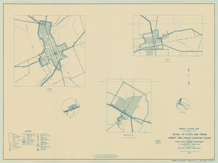
General Highway Map. Detail of Cities and Towns in Kinney County, Uvalde County [Uvalde and vicinity]
Print $20.00
General Highway Map. Detail of Cities and Towns in Kinney County, Uvalde County [Uvalde and vicinity]
1961
Size: 18.2 x 24.6 inches
79557
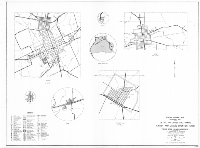
General Highway Map. Detail of Cities and Towns in Kinney County, Uvalde County [Uvalde and vicinity, Sabinal, and Brackettville and vicinity]
Print $20.00
General Highway Map. Detail of Cities and Towns in Kinney County, Uvalde County [Uvalde and vicinity, Sabinal, and Brackettville and vicinity]
1940
Size: 18.5 x 24.7 inches
79163
Kinney County Rolled Sketch 16

Print $20.00
- Digital $50.00
Kinney County Rolled Sketch 16
1963
Size: 37.4 x 44.7 inches
9355
Kinney County Rolled Sketch 16

Print $20.00
- Digital $50.00
Kinney County Rolled Sketch 16
1963
Size: 36.4 x 43.8 inches
9356
Kinney County Sketch File 12

Print $24.00
- Digital $50.00
Kinney County Sketch File 12
1885
Size: 20.7 x 38.6 inches
10618
Kinney County Sketch File 14

Print $6.00
- Digital $50.00
Kinney County Sketch File 14
1886
Size: 10.9 x 16.6 inches
29131
Kinney County Working Sketch 19

Print $20.00
- Digital $50.00
Kinney County Working Sketch 19
1948
Size: 32.0 x 35.7 inches
70201
Kinney County Working Sketch 21

Print $20.00
- Digital $50.00
Kinney County Working Sketch 21
1950
Size: 23.7 x 18.5 inches
70203
Kinney County Working Sketch 25

Print $20.00
- Digital $50.00
Kinney County Working Sketch 25
1952
Size: 30.9 x 32.9 inches
70207
Kinney County Working Sketch 30

Print $40.00
- Digital $50.00
Kinney County Working Sketch 30
1959
Size: 52.6 x 34.7 inches
70212
Kinney County Working Sketch 32

Print $20.00
- Digital $50.00
Kinney County Working Sketch 32
1961
Size: 32.6 x 42.5 inches
70214
Kinney County Working Sketch 39

Print $20.00
- Digital $50.00
Kinney County Working Sketch 39
1972
Size: 37.7 x 44.8 inches
70221
Kinney County Working Sketch 45

Print $20.00
- Digital $50.00
Kinney County Working Sketch 45
1978
Size: 28.6 x 26.5 inches
70227
Kinney County Working Sketch 58

Print $20.00
- Digital $50.00
Kinney County Working Sketch 58
1996
Size: 36.1 x 31.7 inches
70240
Location Map of Memphis, El Paso & Pacific Railroad through Medina & Uvalde Counties

Print $40.00
- Digital $50.00
Location Map of Memphis, El Paso & Pacific Railroad through Medina & Uvalde Counties
1882
Size: 19.2 x 102.0 inches
64444
Map of Uvalde Co.

Print $20.00
- Digital $50.00
Map of Uvalde Co.
1893
Size: 42.7 x 42.5 inches
16911
Map of Uvalde County

Print $20.00
- Digital $50.00
Map of Uvalde County
1862
Size: 27.4 x 20.7 inches
4109
Map showing connection of land-lines with M. & P. E. Ry. through Uvalde Co.

Print $40.00
- Digital $50.00
Map showing connection of land-lines with M. & P. E. Ry. through Uvalde Co.
1882
Size: 11.8 x 86.3 inches
64179
Medina County Rolled Sketch 3

Print $40.00
- Digital $50.00
Medina County Rolled Sketch 3
Size: 40.9 x 54.5 inches
9504
Medina County Sketch File 10

Print $20.00
- Digital $50.00
Medina County Sketch File 10
Size: 18.0 x 22.6 inches
12068
Medina County Sketch File 12

Print $6.00
- Digital $50.00
Medina County Sketch File 12
1907
Size: 7.2 x 8.8 inches
31468
Medina County Sketch File 21

Print $38.00
- Digital $50.00
Medina County Sketch File 21
2002
Size: 11.2 x 8.7 inches
76343
Medina County Working Sketch 2

Print $20.00
- Digital $50.00
Medina County Working Sketch 2
1942
Size: 30.3 x 31.0 inches
70917
Crockett County Sketch File 8 (1)
Print $6.00
- Digital $50.00
Crockett County Sketch File 8 (1)
1858
-
Size
9.8 x 4.6 inches
-
Map/Doc
19652
-
Creation Date
1858
Edwards County Rolled Sketch 9
Print $20.00
- Digital $50.00
Edwards County Rolled Sketch 9
1885
-
Size
29.3 x 42.8 inches
-
Map/Doc
5802
-
Creation Date
1885
Edwards County Working Sketch 15
Print $20.00
- Digital $50.00
Edwards County Working Sketch 15
1927
-
Size
30.0 x 28.4 inches
-
Map/Doc
68891
-
Creation Date
1927
Edwards County Working Sketch 57
Print $20.00
- Digital $50.00
Edwards County Working Sketch 57
1952
-
Size
22.7 x 32.3 inches
-
Map/Doc
68933
-
Creation Date
1952
General Highway Map, Kinney County, Uvalde County, Texas
Print $20.00
General Highway Map, Kinney County, Uvalde County, Texas
1940
-
Size
18.4 x 24.8 inches
-
Map/Doc
79162
-
Creation Date
1940
General Highway Map, Kinney County, Uvalde County, Texas
Print $20.00
General Highway Map, Kinney County, Uvalde County, Texas
1961
-
Size
18.2 x 24.6 inches
-
Map/Doc
79556
-
Creation Date
1961
General Highway Map. Detail of Cities and Towns in Kinney County, Uvalde County [Uvalde and vicinity]
Print $20.00
General Highway Map. Detail of Cities and Towns in Kinney County, Uvalde County [Uvalde and vicinity]
1961
-
Size
18.2 x 24.6 inches
-
Map/Doc
79557
-
Creation Date
1961
General Highway Map. Detail of Cities and Towns in Kinney County, Uvalde County [Uvalde and vicinity, Sabinal, and Brackettville and vicinity]
Print $20.00
General Highway Map. Detail of Cities and Towns in Kinney County, Uvalde County [Uvalde and vicinity, Sabinal, and Brackettville and vicinity]
1940
-
Size
18.5 x 24.7 inches
-
Map/Doc
79163
-
Creation Date
1940
Kinney County Rolled Sketch 16
Print $20.00
- Digital $50.00
Kinney County Rolled Sketch 16
1963
-
Size
37.4 x 44.7 inches
-
Map/Doc
9355
-
Creation Date
1963
Kinney County Rolled Sketch 16
Print $20.00
- Digital $50.00
Kinney County Rolled Sketch 16
1963
-
Size
36.4 x 43.8 inches
-
Map/Doc
9356
-
Creation Date
1963
Kinney County Sketch File 12
Print $24.00
- Digital $50.00
Kinney County Sketch File 12
1885
-
Size
20.7 x 38.6 inches
-
Map/Doc
10618
-
Creation Date
1885
Kinney County Sketch File 14
Print $6.00
- Digital $50.00
Kinney County Sketch File 14
1886
-
Size
10.9 x 16.6 inches
-
Map/Doc
29131
-
Creation Date
1886
Kinney County Working Sketch 19
Print $20.00
- Digital $50.00
Kinney County Working Sketch 19
1948
-
Size
32.0 x 35.7 inches
-
Map/Doc
70201
-
Creation Date
1948
Kinney County Working Sketch 21
Print $20.00
- Digital $50.00
Kinney County Working Sketch 21
1950
-
Size
23.7 x 18.5 inches
-
Map/Doc
70203
-
Creation Date
1950
Kinney County Working Sketch 25
Print $20.00
- Digital $50.00
Kinney County Working Sketch 25
1952
-
Size
30.9 x 32.9 inches
-
Map/Doc
70207
-
Creation Date
1952
Kinney County Working Sketch 30
Print $40.00
- Digital $50.00
Kinney County Working Sketch 30
1959
-
Size
52.6 x 34.7 inches
-
Map/Doc
70212
-
Creation Date
1959
Kinney County Working Sketch 32
Print $20.00
- Digital $50.00
Kinney County Working Sketch 32
1961
-
Size
32.6 x 42.5 inches
-
Map/Doc
70214
-
Creation Date
1961
Kinney County Working Sketch 39
Print $20.00
- Digital $50.00
Kinney County Working Sketch 39
1972
-
Size
37.7 x 44.8 inches
-
Map/Doc
70221
-
Creation Date
1972
Kinney County Working Sketch 45
Print $20.00
- Digital $50.00
Kinney County Working Sketch 45
1978
-
Size
28.6 x 26.5 inches
-
Map/Doc
70227
-
Creation Date
1978
Kinney County Working Sketch 58
Print $20.00
- Digital $50.00
Kinney County Working Sketch 58
1996
-
Size
36.1 x 31.7 inches
-
Map/Doc
70240
-
Creation Date
1996
Location Map of Memphis, El Paso & Pacific Railroad through Medina & Uvalde Counties
Print $40.00
- Digital $50.00
Location Map of Memphis, El Paso & Pacific Railroad through Medina & Uvalde Counties
1882
-
Size
19.2 x 102.0 inches
-
Map/Doc
64444
-
Creation Date
1882
Map of Uvalde Co.
Print $20.00
- Digital $50.00
Map of Uvalde Co.
1893
-
Size
42.7 x 42.5 inches
-
Map/Doc
16911
-
Creation Date
1893
Map of Uvalde Co.

Print $20.00
- Digital $50.00
Map of Uvalde Co.
-
Size
41.0 x 43.9 inches
-
Map/Doc
63090
Map of Uvalde County
Print $20.00
- Digital $50.00
Map of Uvalde County
1862
-
Size
27.4 x 20.7 inches
-
Map/Doc
4109
-
Creation Date
1862
Map showing connection of land-lines with M. & P. E. Ry. through Uvalde Co.
Print $40.00
- Digital $50.00
Map showing connection of land-lines with M. & P. E. Ry. through Uvalde Co.
1882
-
Size
11.8 x 86.3 inches
-
Map/Doc
64179
-
Creation Date
1882
Medina County Rolled Sketch 3
Print $40.00
- Digital $50.00
Medina County Rolled Sketch 3
-
Size
40.9 x 54.5 inches
-
Map/Doc
9504
Medina County Sketch File 10
Print $20.00
- Digital $50.00
Medina County Sketch File 10
-
Size
18.0 x 22.6 inches
-
Map/Doc
12068
Medina County Sketch File 12
Print $6.00
- Digital $50.00
Medina County Sketch File 12
1907
-
Size
7.2 x 8.8 inches
-
Map/Doc
31468
-
Creation Date
1907
Medina County Sketch File 21
Print $38.00
- Digital $50.00
Medina County Sketch File 21
2002
-
Size
11.2 x 8.7 inches
-
Map/Doc
76343
-
Creation Date
2002
Medina County Working Sketch 2
Print $20.00
- Digital $50.00
Medina County Working Sketch 2
1942
-
Size
30.3 x 31.0 inches
-
Map/Doc
70917
-
Creation Date
1942