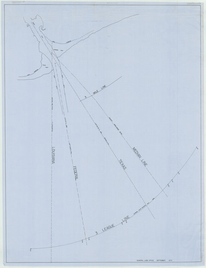
[Three Mile Line and Three League Line]
Print $20.00
- Digital $50.00
[Three Mile Line and Three League Line]
1973
Size: 43.2 x 33.3 inches
76120
Shipping Safety Fairways and Anchorage Areas, Gulf of Mexico - Brazos Santiago Pass to Calcasieu Pass

Print $20.00
- Digital $50.00
Shipping Safety Fairways and Anchorage Areas, Gulf of Mexico - Brazos Santiago Pass to Calcasieu Pass
1968
Size: 30.3 x 42.1 inches
73632
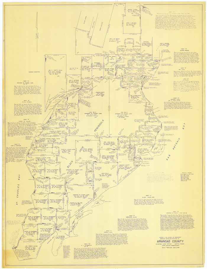
[Aransas Wildlife Refuge]
Print $40.00
- Digital $50.00
[Aransas Wildlife Refuge]
1965
Size: 55.6 x 42.9 inches
2081
Map of a part of Laguna Madre showing subdivision for mineral development

Print $40.00
- Digital $50.00
Map of a part of Laguna Madre showing subdivision for mineral development
1963
Size: 68.1 x 46.0 inches
2916
[Three-Marine League line stipulation as determined by US Supreme Court, October 1968 term; corrections to stipulation; Texas GLO approximations of county areas embraced by county boundaries, shoreline and 3-marine league line and 3-mile line]

Print $64.00
[Three-Marine League line stipulation as determined by US Supreme Court, October 1968 term; corrections to stipulation; Texas GLO approximations of county areas embraced by county boundaries, shoreline and 3-marine league line and 3-mile line]
1962
Size: 13.4 x 8.7 inches
61371
Current Miscellaneous File 67

Print $8.00
- Digital $50.00
Current Miscellaneous File 67
1957
Size: 11.2 x 8.8 inches
74130
[Aerial Photograph of Galveston Island and the Gulf of Mexico]
Print $20.00
- Digital $50.00
[Aerial Photograph of Galveston Island and the Gulf of Mexico]
1956
Size: 15.5 x 12.7 inches
83434
Current Miscellaneous File 44

Print $10.00
- Digital $50.00
Current Miscellaneous File 44
1954
Size: 11.3 x 8.8 inches
73985
Current Miscellaneous File 88

Print $12.00
- Digital $50.00
Current Miscellaneous File 88
1954
Size: 10.9 x 8.4 inches
74247
Key to Photo Index Sheets of Texas Coast Portion

Print $20.00
- Digital $50.00
Key to Photo Index Sheets of Texas Coast Portion
1954
Size: 20.0 x 24.0 inches
83436
Key to Photo Index Sheets of Texas Coast Portion

Print $20.00
- Digital $50.00
Key to Photo Index Sheets of Texas Coast Portion
1954
Size: 20.0 x 24.0 inches
83437
Texas Gulf Coast from the Sabine River to the Rio Grande Showing Location of Navigation Districts

Print $20.00
- Digital $50.00
Texas Gulf Coast from the Sabine River to the Rio Grande Showing Location of Navigation Districts
1954
Size: 45.0 x 43.8 inches
73596
Current Miscellaneous File 34

Print $10.00
- Digital $50.00
Current Miscellaneous File 34
1953
Size: 14.1 x 8.7 inches
73942
Current Miscellaneous File 33

Print $6.00
- Digital $50.00
Current Miscellaneous File 33
1953
Size: 10.8 x 8.2 inches
73939
Current Miscellaneous File 15

Print $16.00
- Digital $50.00
Current Miscellaneous File 15
1951
Size: 10.7 x 8.2 inches
73822
Map of a part of Laguna Madre showing subdivision for mineral development

Print $20.00
- Digital $50.00
Map of a part of Laguna Madre showing subdivision for mineral development
1950
Size: 40.7 x 26.9 inches
2917
Colored Map of Texas Gulf Coast from Sabine River to the Rio Grande

Print $20.00
- Digital $50.00
Colored Map of Texas Gulf Coast from Sabine River to the Rio Grande
1950
Size: 44.7 x 43.0 inches
3014
Map of a part of Laguna Madre in Willacy & Cameron Counties showing subdivision for mineral development

Print $20.00
- Digital $50.00
Map of a part of Laguna Madre in Willacy & Cameron Counties showing subdivision for mineral development
1950
Size: 46.9 x 37.0 inches
3097
Current Miscellaneous File 24a

Print $8.00
- Digital $50.00
Current Miscellaneous File 24a
1949
Size: 11.0 x 8.6 inches
73893
Map of a part of Laguna Madre showing subdivision for mineral development

Print $20.00
- Digital $50.00
Map of a part of Laguna Madre showing subdivision for mineral development
1948
Size: 42.9 x 31.0 inches
2913
Map of a part of Laguna Madre showing subdivision for mineral development

Print $20.00
- Digital $50.00
Map of a part of Laguna Madre showing subdivision for mineral development
1948
Size: 37.4 x 27.7 inches
2914
Port Aransas-Corpus Christi Waterway, Texas, Avery Point Turning Basin to Vicinity of Tule Lake - Dredging

Print $20.00
- Digital $50.00
Port Aransas-Corpus Christi Waterway, Texas, Avery Point Turning Basin to Vicinity of Tule Lake - Dredging
1947
Size: 28.6 x 41.8 inches
1996
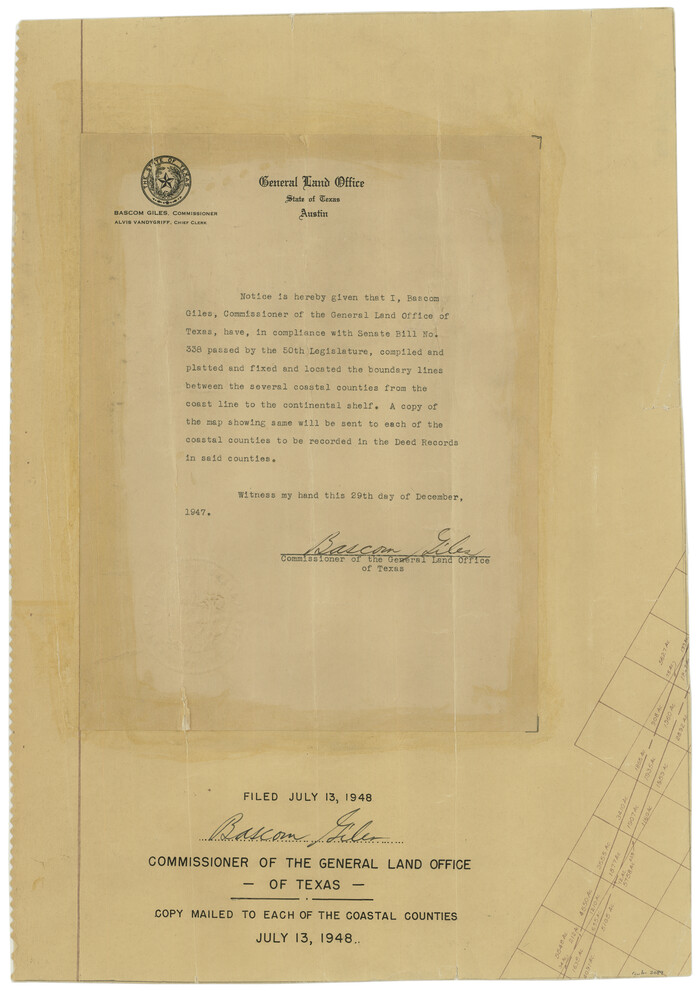
[Affadavit regarding boundary lines between the several coastal counties from coastline to Continental Shelf]
Print $20.00
- Digital $50.00
[Affadavit regarding boundary lines between the several coastal counties from coastline to Continental Shelf]
1947
Size: 18.1 x 12.7 inches
2089
Map of a part of Laguna Madre showing subdivision for mineral development

Print $40.00
- Digital $50.00
Map of a part of Laguna Madre showing subdivision for mineral development
1946
Size: 50.0 x 29.0 inches
2915
Map of Texas coastal area showing submerged area to which counties along the Gulf of Mexico are entitled

Print $20.00
- Digital $50.00
Map of Texas coastal area showing submerged area to which counties along the Gulf of Mexico are entitled
1939
Size: 28.3 x 44.2 inches
3105
Galveston Harbor, Texas - U.S. Harbor Lines - Galveston Harbor, Galveston Channel, Channel from Galveston Harbor to Texas City and Channel to Port Bolivar

Print $20.00
- Digital $50.00
Galveston Harbor, Texas - U.S. Harbor Lines - Galveston Harbor, Galveston Channel, Channel from Galveston Harbor to Texas City and Channel to Port Bolivar
1939
Size: 39.4 x 26.7 inches
73631
Aerial Perspective of Packery Channel

Print $20.00
- Digital $50.00
Aerial Perspective of Packery Channel
1938
Size: 16.5 x 19.3 inches
3001
[Three Mile Line and Three League Line]
Print $20.00
- Digital $50.00
[Three Mile Line and Three League Line]
1973
-
Size
43.2 x 33.3 inches
-
Map/Doc
76120
-
Creation Date
1973
Estes Quadrangle

Print $20.00
- Digital $50.00
Estes Quadrangle
1971
-
Size
27.8 x 23.6 inches
-
Map/Doc
73442
-
Creation Date
1971
Shipping Safety Fairways and Anchorage Areas, Gulf of Mexico - Brazos Santiago Pass to Calcasieu Pass
Print $20.00
- Digital $50.00
Shipping Safety Fairways and Anchorage Areas, Gulf of Mexico - Brazos Santiago Pass to Calcasieu Pass
1968
-
Size
30.3 x 42.1 inches
-
Map/Doc
73632
-
Creation Date
1968
[Aransas Wildlife Refuge]
Print $40.00
- Digital $50.00
[Aransas Wildlife Refuge]
1965
-
Size
55.6 x 42.9 inches
-
Map/Doc
2081
-
Creation Date
1965
Map of a part of Laguna Madre showing subdivision for mineral development
Print $40.00
- Digital $50.00
Map of a part of Laguna Madre showing subdivision for mineral development
1963
-
Size
68.1 x 46.0 inches
-
Map/Doc
2916
-
Creation Date
1963
[Three-Marine League line stipulation as determined by US Supreme Court, October 1968 term; corrections to stipulation; Texas GLO approximations of county areas embraced by county boundaries, shoreline and 3-marine league line and 3-mile line]
Print $64.00
[Three-Marine League line stipulation as determined by US Supreme Court, October 1968 term; corrections to stipulation; Texas GLO approximations of county areas embraced by county boundaries, shoreline and 3-marine league line and 3-mile line]
1962
-
Size
13.4 x 8.7 inches
-
Map/Doc
61371
-
Creation Date
1962
Gulf of Mexico

Print $20.00
- Digital $50.00
Gulf of Mexico
1961
-
Size
36.6 x 43.3 inches
-
Map/Doc
73551
-
Creation Date
1961
Current Miscellaneous File 67
Print $8.00
- Digital $50.00
Current Miscellaneous File 67
1957
-
Size
11.2 x 8.8 inches
-
Map/Doc
74130
-
Creation Date
1957
[Aerial Photograph of Galveston Island and the Gulf of Mexico]
Print $20.00
- Digital $50.00
[Aerial Photograph of Galveston Island and the Gulf of Mexico]
1956
-
Size
15.5 x 12.7 inches
-
Map/Doc
83434
-
Creation Date
1956
Current Miscellaneous File 44
Print $10.00
- Digital $50.00
Current Miscellaneous File 44
1954
-
Size
11.3 x 8.8 inches
-
Map/Doc
73985
-
Creation Date
1954
Current Miscellaneous File 88
Print $12.00
- Digital $50.00
Current Miscellaneous File 88
1954
-
Size
10.9 x 8.4 inches
-
Map/Doc
74247
-
Creation Date
1954
Key to Photo Index Sheets of Texas Coast Portion
Print $20.00
- Digital $50.00
Key to Photo Index Sheets of Texas Coast Portion
1954
-
Size
20.0 x 24.0 inches
-
Map/Doc
83436
-
Creation Date
1954
Key to Photo Index Sheets of Texas Coast Portion
Print $20.00
- Digital $50.00
Key to Photo Index Sheets of Texas Coast Portion
1954
-
Size
20.0 x 24.0 inches
-
Map/Doc
83437
-
Creation Date
1954
Texas Gulf Coast from the Sabine River to the Rio Grande Showing Location of Navigation Districts
Print $20.00
- Digital $50.00
Texas Gulf Coast from the Sabine River to the Rio Grande Showing Location of Navigation Districts
1954
-
Size
45.0 x 43.8 inches
-
Map/Doc
73596
-
Creation Date
1954
Current Miscellaneous File 34
Print $10.00
- Digital $50.00
Current Miscellaneous File 34
1953
-
Size
14.1 x 8.7 inches
-
Map/Doc
73942
-
Creation Date
1953
Current Miscellaneous File 33
Print $6.00
- Digital $50.00
Current Miscellaneous File 33
1953
-
Size
10.8 x 8.2 inches
-
Map/Doc
73939
-
Creation Date
1953
Current Miscellaneous File 15
Print $16.00
- Digital $50.00
Current Miscellaneous File 15
1951
-
Size
10.7 x 8.2 inches
-
Map/Doc
73822
-
Creation Date
1951
Map of a part of Laguna Madre showing subdivision for mineral development
Print $20.00
- Digital $50.00
Map of a part of Laguna Madre showing subdivision for mineral development
1950
-
Size
40.7 x 26.9 inches
-
Map/Doc
2917
-
Creation Date
1950
Colored Map of Texas Gulf Coast from Sabine River to the Rio Grande
Print $20.00
- Digital $50.00
Colored Map of Texas Gulf Coast from Sabine River to the Rio Grande
1950
-
Size
44.7 x 43.0 inches
-
Map/Doc
3014
-
Creation Date
1950
Map of a part of Laguna Madre in Willacy & Cameron Counties showing subdivision for mineral development
Print $20.00
- Digital $50.00
Map of a part of Laguna Madre in Willacy & Cameron Counties showing subdivision for mineral development
1950
-
Size
46.9 x 37.0 inches
-
Map/Doc
3097
-
Creation Date
1950
Current Miscellaneous File 24a
Print $8.00
- Digital $50.00
Current Miscellaneous File 24a
1949
-
Size
11.0 x 8.6 inches
-
Map/Doc
73893
-
Creation Date
1949
Map of a part of Laguna Madre showing subdivision for mineral development
Print $20.00
- Digital $50.00
Map of a part of Laguna Madre showing subdivision for mineral development
1948
-
Size
42.9 x 31.0 inches
-
Map/Doc
2913
-
Creation Date
1948
Map of a part of Laguna Madre showing subdivision for mineral development
Print $20.00
- Digital $50.00
Map of a part of Laguna Madre showing subdivision for mineral development
1948
-
Size
37.4 x 27.7 inches
-
Map/Doc
2914
-
Creation Date
1948
Port Aransas-Corpus Christi Waterway, Texas, Avery Point Turning Basin to Vicinity of Tule Lake - Dredging
Print $20.00
- Digital $50.00
Port Aransas-Corpus Christi Waterway, Texas, Avery Point Turning Basin to Vicinity of Tule Lake - Dredging
1947
-
Size
28.6 x 41.8 inches
-
Map/Doc
1996
-
Creation Date
1947
[Affadavit regarding boundary lines between the several coastal counties from coastline to Continental Shelf]
Print $20.00
- Digital $50.00
[Affadavit regarding boundary lines between the several coastal counties from coastline to Continental Shelf]
1947
-
Size
18.1 x 12.7 inches
-
Map/Doc
2089
-
Creation Date
1947
Gulf of Mexico

Print $20.00
- Digital $50.00
Gulf of Mexico
1946
-
Size
36.2 x 43.7 inches
-
Map/Doc
73550
-
Creation Date
1946
Map of a part of Laguna Madre showing subdivision for mineral development
Print $40.00
- Digital $50.00
Map of a part of Laguna Madre showing subdivision for mineral development
1946
-
Size
50.0 x 29.0 inches
-
Map/Doc
2915
-
Creation Date
1946
Map of Texas coastal area showing submerged area to which counties along the Gulf of Mexico are entitled
Print $20.00
- Digital $50.00
Map of Texas coastal area showing submerged area to which counties along the Gulf of Mexico are entitled
1939
-
Size
28.3 x 44.2 inches
-
Map/Doc
3105
-
Creation Date
1939
Galveston Harbor, Texas - U.S. Harbor Lines - Galveston Harbor, Galveston Channel, Channel from Galveston Harbor to Texas City and Channel to Port Bolivar
Print $20.00
- Digital $50.00
Galveston Harbor, Texas - U.S. Harbor Lines - Galveston Harbor, Galveston Channel, Channel from Galveston Harbor to Texas City and Channel to Port Bolivar
1939
-
Size
39.4 x 26.7 inches
-
Map/Doc
73631
-
Creation Date
1939
Aerial Perspective of Packery Channel
Print $20.00
- Digital $50.00
Aerial Perspective of Packery Channel
1938
-
Size
16.5 x 19.3 inches
-
Map/Doc
3001
-
Creation Date
1938