Port Aransas-Corpus Christi Waterway, Texas, Avery Point Turning Basin to Vicinity of Tule Lake - Dredging

Print $20.00
- Digital $50.00
Port Aransas-Corpus Christi Waterway, Texas, Avery Point Turning Basin to Vicinity of Tule Lake - Dredging
1947
Size: 28.6 x 41.8 inches
1996
Map of Matagorda Bay and County with the Adjacent Country

Print $20.00
- Digital $50.00
Map of Matagorda Bay and County with the Adjacent Country
1839
Size: 33.4 x 42.6 inches
2002
[Aransas Wildlife Refuge]
Print $40.00
- Digital $50.00
[Aransas Wildlife Refuge]
1965
Size: 55.6 x 42.9 inches
2081
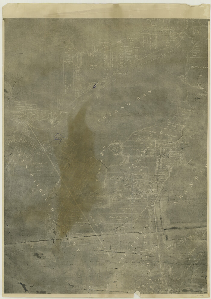
[William Steele Survey near Copano Bay]
Print $20.00
- Digital $50.00
[William Steele Survey near Copano Bay]
1927
Size: 26.1 x 18.4 inches
2082
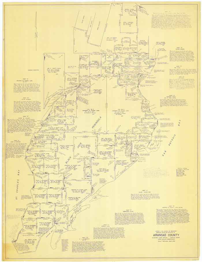
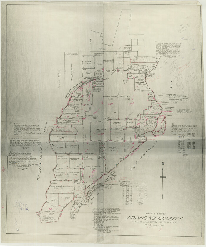
[Aransas County, Texas]
Print $20.00
- Digital $50.00
[Aransas County, Texas]
1928
Size: 37.5 x 31.3 inches
2083
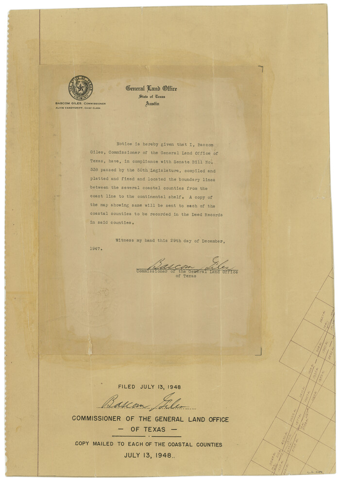
[Affadavit regarding boundary lines between the several coastal counties from coastline to Continental Shelf]
Print $20.00
- Digital $50.00
[Affadavit regarding boundary lines between the several coastal counties from coastline to Continental Shelf]
1947
Size: 18.1 x 12.7 inches
2089
Aransas Migratory Waterfowl Refuge in Aransas and Refugio Counties

Print $20.00
- Digital $50.00
Aransas Migratory Waterfowl Refuge in Aransas and Refugio Counties
1937
Size: 40.3 x 31.0 inches
2693
Map of a part of Laguna Madre showing subdivision for mineral development

Print $20.00
- Digital $50.00
Map of a part of Laguna Madre showing subdivision for mineral development
1948
Size: 42.9 x 31.0 inches
2913
Map of a part of Laguna Madre showing subdivision for mineral development

Print $20.00
- Digital $50.00
Map of a part of Laguna Madre showing subdivision for mineral development
1948
Size: 37.4 x 27.7 inches
2914
Map of a part of Laguna Madre showing subdivision for mineral development

Print $40.00
- Digital $50.00
Map of a part of Laguna Madre showing subdivision for mineral development
1946
Size: 50.0 x 29.0 inches
2915
Map of a part of Laguna Madre showing subdivision for mineral development

Print $40.00
- Digital $50.00
Map of a part of Laguna Madre showing subdivision for mineral development
1963
Size: 68.1 x 46.0 inches
2916
Map of a part of Laguna Madre showing subdivision for mineral development

Print $20.00
- Digital $50.00
Map of a part of Laguna Madre showing subdivision for mineral development
1950
Size: 40.7 x 26.9 inches
2917
Aerial Perspective of Packery Channel

Print $20.00
- Digital $50.00
Aerial Perspective of Packery Channel
1938
Size: 16.5 x 19.3 inches
3001
Colored Map of Texas Gulf Coast from Sabine River to the Rio Grande

Print $20.00
- Digital $50.00
Colored Map of Texas Gulf Coast from Sabine River to the Rio Grande
1950
Size: 44.7 x 43.0 inches
3014
Aransas Migratory Waterfowl Refuge, San Antonio Loan & Trust Company Tracts, 45,596.98 acres, Aransas and Refugio Counties

Print $20.00
- Digital $50.00
Aransas Migratory Waterfowl Refuge, San Antonio Loan & Trust Company Tracts, 45,596.98 acres, Aransas and Refugio Counties
1937
Size: 41.1 x 30.8 inches
3073
Map of a part of Laguna Madre in Willacy & Cameron Counties showing subdivision for mineral development

Print $20.00
- Digital $50.00
Map of a part of Laguna Madre in Willacy & Cameron Counties showing subdivision for mineral development
1950
Size: 46.9 x 37.0 inches
3097
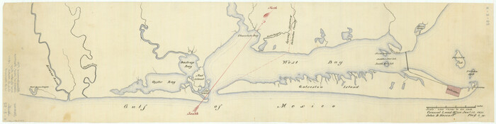
[Sketch of Oyster Bay, Bastrop Bay, Chocolate Bay, and West Bay]
Print $20.00
- Digital $50.00
[Sketch of Oyster Bay, Bastrop Bay, Chocolate Bay, and West Bay]
1871
Size: 6.0 x 23.9 inches
3103
Map of Texas coastal area showing submerged area to which counties along the Gulf of Mexico are entitled

Print $20.00
- Digital $50.00
Map of Texas coastal area showing submerged area to which counties along the Gulf of Mexico are entitled
1939
Size: 28.3 x 44.2 inches
3105
Topography and water depth as shown by the U.S. Coast Survey of 1888

Print $20.00
- Digital $50.00
Topography and water depth as shown by the U.S. Coast Survey of 1888
1890
Size: 17.0 x 18.8 inches
390
Sketch of a part of Galveston Island

Print $3.00
- Digital $50.00
Sketch of a part of Galveston Island
Size: 10.8 x 13.8 inches
430
Map of Surveys on Harbor Island

Print $40.00
- Digital $50.00
Map of Surveys on Harbor Island
1912
Size: 57.3 x 42.2 inches
594
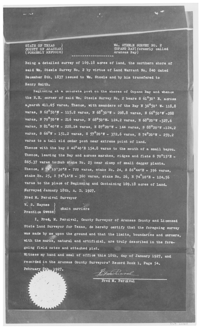
[William Steele Survey near Copano Bay]
Print $3.00
- Digital $50.00
[William Steele Survey near Copano Bay]
1927
Size: 15.5 x 9.5 inches
60284
[William Steele Survey near Copano Bay]
Print $3.00
- Digital $50.00
[William Steele Survey near Copano Bay]
1927
Size: 14.9 x 9.8 inches
60285
[Three-Marine League line stipulation as determined by US Supreme Court, October 1968 term; corrections to stipulation; Texas GLO approximations of county areas embraced by county boundaries, shoreline and 3-marine league line and 3-mile line]

Print $64.00
[Three-Marine League line stipulation as determined by US Supreme Court, October 1968 term; corrections to stipulation; Texas GLO approximations of county areas embraced by county boundaries, shoreline and 3-marine league line and 3-mile line]
1962
Size: 13.4 x 8.7 inches
61371
Port Aransas-Corpus Christi Waterway, Texas, Avery Point Turning Basin to Vicinity of Tule Lake - Dredging
Print $20.00
- Digital $50.00
Port Aransas-Corpus Christi Waterway, Texas, Avery Point Turning Basin to Vicinity of Tule Lake - Dredging
1947
-
Size
28.6 x 41.8 inches
-
Map/Doc
1996
-
Creation Date
1947
Map of Matagorda Bay and County with the Adjacent Country
Print $20.00
- Digital $50.00
Map of Matagorda Bay and County with the Adjacent Country
1839
-
Size
33.4 x 42.6 inches
-
Map/Doc
2002
-
Creation Date
1839
[Aransas Wildlife Refuge]
Print $40.00
- Digital $50.00
[Aransas Wildlife Refuge]
1965
-
Size
55.6 x 42.9 inches
-
Map/Doc
2081
-
Creation Date
1965
[William Steele Survey near Copano Bay]
Print $20.00
- Digital $50.00
[William Steele Survey near Copano Bay]
1927
-
Size
26.1 x 18.4 inches
-
Map/Doc
2082
-
Creation Date
1927
[Aransas County, Texas]
Print $20.00
- Digital $50.00
[Aransas County, Texas]
1928
-
Size
37.5 x 31.3 inches
-
Map/Doc
2083
-
Creation Date
1928
[Affadavit regarding boundary lines between the several coastal counties from coastline to Continental Shelf]
Print $20.00
- Digital $50.00
[Affadavit regarding boundary lines between the several coastal counties from coastline to Continental Shelf]
1947
-
Size
18.1 x 12.7 inches
-
Map/Doc
2089
-
Creation Date
1947
Aransas Migratory Waterfowl Refuge in Aransas and Refugio Counties
Print $20.00
- Digital $50.00
Aransas Migratory Waterfowl Refuge in Aransas and Refugio Counties
1937
-
Size
40.3 x 31.0 inches
-
Map/Doc
2693
-
Creation Date
1937
Map of a part of Laguna Madre showing subdivision for mineral development
Print $20.00
- Digital $50.00
Map of a part of Laguna Madre showing subdivision for mineral development
1948
-
Size
42.9 x 31.0 inches
-
Map/Doc
2913
-
Creation Date
1948
Map of a part of Laguna Madre showing subdivision for mineral development
Print $20.00
- Digital $50.00
Map of a part of Laguna Madre showing subdivision for mineral development
1948
-
Size
37.4 x 27.7 inches
-
Map/Doc
2914
-
Creation Date
1948
Map of a part of Laguna Madre showing subdivision for mineral development
Print $40.00
- Digital $50.00
Map of a part of Laguna Madre showing subdivision for mineral development
1946
-
Size
50.0 x 29.0 inches
-
Map/Doc
2915
-
Creation Date
1946
Map of a part of Laguna Madre showing subdivision for mineral development
Print $40.00
- Digital $50.00
Map of a part of Laguna Madre showing subdivision for mineral development
1963
-
Size
68.1 x 46.0 inches
-
Map/Doc
2916
-
Creation Date
1963
Map of a part of Laguna Madre showing subdivision for mineral development
Print $20.00
- Digital $50.00
Map of a part of Laguna Madre showing subdivision for mineral development
1950
-
Size
40.7 x 26.9 inches
-
Map/Doc
2917
-
Creation Date
1950
Aerial Perspective of Packery Channel
Print $20.00
- Digital $50.00
Aerial Perspective of Packery Channel
1938
-
Size
16.5 x 19.3 inches
-
Map/Doc
3001
-
Creation Date
1938
Colored Map of Texas Gulf Coast from Sabine River to the Rio Grande
Print $20.00
- Digital $50.00
Colored Map of Texas Gulf Coast from Sabine River to the Rio Grande
1950
-
Size
44.7 x 43.0 inches
-
Map/Doc
3014
-
Creation Date
1950
Aransas Migratory Waterfowl Refuge, San Antonio Loan & Trust Company Tracts, 45,596.98 acres, Aransas and Refugio Counties
Print $20.00
- Digital $50.00
Aransas Migratory Waterfowl Refuge, San Antonio Loan & Trust Company Tracts, 45,596.98 acres, Aransas and Refugio Counties
1937
-
Size
41.1 x 30.8 inches
-
Map/Doc
3073
-
Creation Date
1937
Map of a part of Laguna Madre in Willacy & Cameron Counties showing subdivision for mineral development
Print $20.00
- Digital $50.00
Map of a part of Laguna Madre in Willacy & Cameron Counties showing subdivision for mineral development
1950
-
Size
46.9 x 37.0 inches
-
Map/Doc
3097
-
Creation Date
1950
[Sketch of Oyster Bay, Bastrop Bay, Chocolate Bay, and West Bay]
Print $20.00
- Digital $50.00
[Sketch of Oyster Bay, Bastrop Bay, Chocolate Bay, and West Bay]
1871
-
Size
6.0 x 23.9 inches
-
Map/Doc
3103
-
Creation Date
1871
Map of Texas coastal area showing submerged area to which counties along the Gulf of Mexico are entitled
Print $20.00
- Digital $50.00
Map of Texas coastal area showing submerged area to which counties along the Gulf of Mexico are entitled
1939
-
Size
28.3 x 44.2 inches
-
Map/Doc
3105
-
Creation Date
1939
Topography and water depth as shown by the U.S. Coast Survey of 1888
Print $20.00
- Digital $50.00
Topography and water depth as shown by the U.S. Coast Survey of 1888
1890
-
Size
17.0 x 18.8 inches
-
Map/Doc
390
-
Creation Date
1890
Sketch of a part of Galveston Island
Print $3.00
- Digital $50.00
Sketch of a part of Galveston Island
-
Size
10.8 x 13.8 inches
-
Map/Doc
430
Map of Surveys on Harbor Island
Print $40.00
- Digital $50.00
Map of Surveys on Harbor Island
1912
-
Size
57.3 x 42.2 inches
-
Map/Doc
594
-
Creation Date
1912
[William Steele Survey near Copano Bay]
Print $3.00
- Digital $50.00
[William Steele Survey near Copano Bay]
1927
-
Size
15.5 x 9.5 inches
-
Map/Doc
60284
-
Creation Date
1927
[William Steele Survey near Copano Bay]
Print $3.00
- Digital $50.00
[William Steele Survey near Copano Bay]
1927
-
Size
14.9 x 9.8 inches
-
Map/Doc
60285
-
Creation Date
1927
[Three-Marine League line stipulation as determined by US Supreme Court, October 1968 term; corrections to stipulation; Texas GLO approximations of county areas embraced by county boundaries, shoreline and 3-marine league line and 3-mile line]
Print $64.00
[Three-Marine League line stipulation as determined by US Supreme Court, October 1968 term; corrections to stipulation; Texas GLO approximations of county areas embraced by county boundaries, shoreline and 3-marine league line and 3-mile line]
1962
-
Size
13.4 x 8.7 inches
-
Map/Doc
61371
-
Creation Date
1962
Gulf of Mexico

Print $20.00
- Digital $50.00
Gulf of Mexico
1900
-
Size
18.2 x 28.1 inches
-
Map/Doc
72647
-
Creation Date
1900
Gulf of Mexico

Print $20.00
- Digital $50.00
Gulf of Mexico
1900
-
Size
18.2 x 28.0 inches
-
Map/Doc
72648
-
Creation Date
1900
Gulf of Mexico

Print $20.00
- Digital $50.00
Gulf of Mexico
1900
-
Size
18.4 x 28.1 inches
-
Map/Doc
72649
-
Creation Date
1900
Gulf of Mexico

Print $20.00
- Digital $50.00
Gulf of Mexico
1900
-
Size
18.3 x 28.1 inches
-
Map/Doc
72650
-
Creation Date
1900
Gulf of Mexico

Print $20.00
- Digital $50.00
Gulf of Mexico
1905
-
Size
18.2 x 26.8 inches
-
Map/Doc
72651
-
Creation Date
1905
Gulf of Mexico

Print $20.00
- Digital $50.00
Gulf of Mexico
1905
-
Size
18.3 x 26.8 inches
-
Map/Doc
72652
-
Creation Date
1905