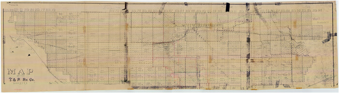
[Index map of T. & P. Ry. Company’s 80-mile Trans-Pecos Reserve’s perpetuated corners - South Part]
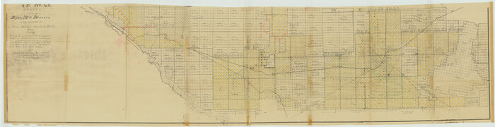
Print $40.00
- Digital $50.00
[Index map of T. & P. Ry. Company’s 80-mile Trans-Pecos Reserve’s perpetuated corners - South Part]
Size: 23.1 x 90.1 inches
69766
Current Miscellaneous File 29

Print $10.00
- Digital $50.00
Current Miscellaneous File 29
Size: 11.2 x 8.8 inches
73920
Andrews County Rolled Sketch 42

Print $20.00
- Digital $50.00
Andrews County Rolled Sketch 42
Size: 27.3 x 36.0 inches
77182
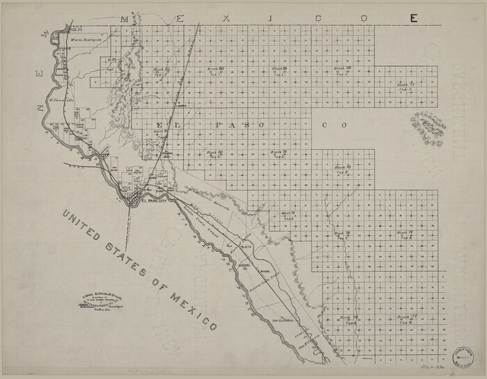
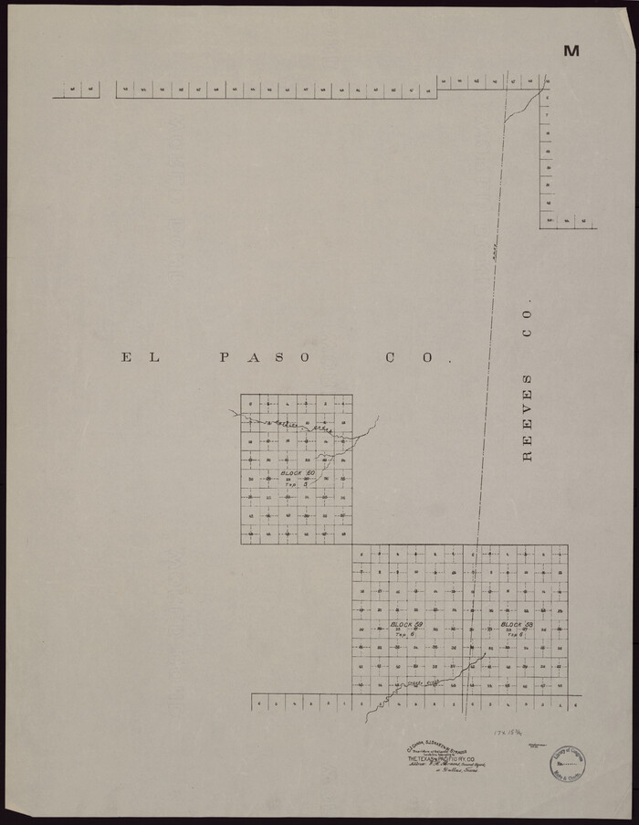
[Map showing T&P Lands in El Paso County]
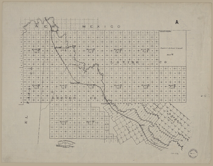
Print $20.00
[Map showing T&P Lands in El Paso County]
Size: 17.5 x 22.3 inches
88930
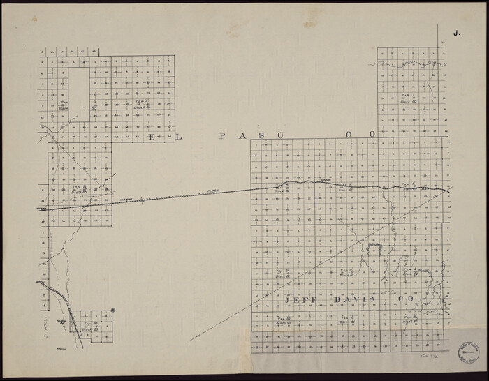
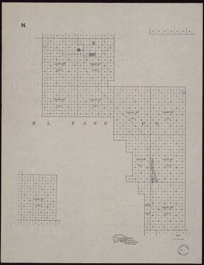
[Map showing T&P Lands in El Paso County]
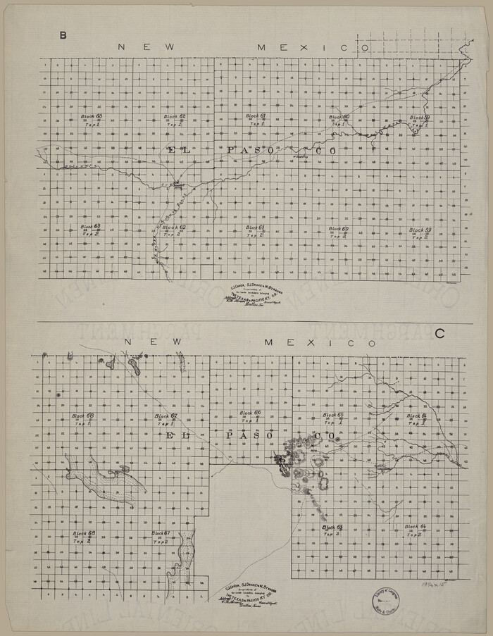
Print $20.00
[Map showing T&P Lands in El Paso County]
Size: 22.4 x 17.3 inches
88931
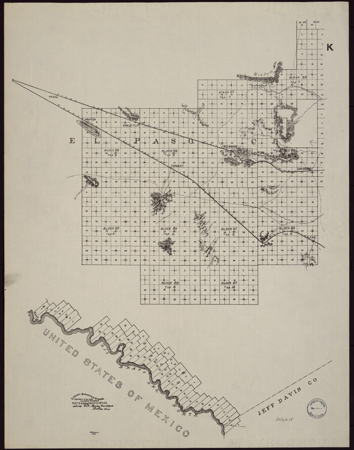
[Map showing T&P Lands in El Paso County]
Print $20.00
[Map showing T&P Lands in El Paso County]
Size: 22.2 x 17.1 inches
88932
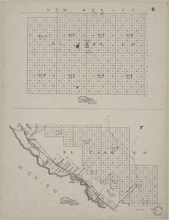
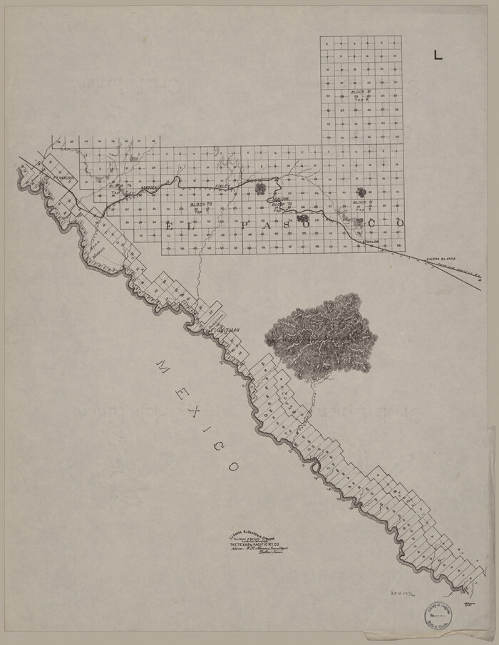
[Map showing T&P Lands in El Paso County]
Print $20.00
[Map showing T&P Lands in El Paso County]
Size: 17.2 x 22.1 inches
88933
[Map showing T&P Lands in El Paso County]
Print $20.00
[Map showing T&P Lands in El Paso County]
Size: 17.3 x 22.2 inches
88934
[Map showing T&P Lands in El Paso County]
Print $20.00
[Map showing T&P Lands in El Paso County]
Size: 22.2 x 17.4 inches
88935
[Map showing T&P Lands in El Paso County]
Print $20.00
[Map showing T&P Lands in El Paso County]
Size: 22.6 x 17.5 inches
88936
[Map showing T&P Lands in El Paso County]
Print $20.00
[Map showing T&P Lands in El Paso County]
Size: 22.3 x 17.3 inches
88937
[Map showing T&P Lands in El Paso County]
Print $20.00
[Map showing T&P Lands in El Paso County]
Size: 22.4 x 17.2 inches
88938
[Index map of T. & P. Ry. Company’s 80-mile Trans-Pecos Reserve’s perpetuated corners - North Part]
Print $40.00
- Digital $50.00
[Index map of T. & P. Ry. Company’s 80-mile Trans-Pecos Reserve’s perpetuated corners - North Part]
Size: 25.4 x 92.1 inches
89622
Red River County, Texas

Print $20.00
- Digital $50.00
Red River County, Texas
Size: 22.2 x 17.2 inches
95756
Map of the State of Texas showing the Line and Lands of the Texas and Pacific Railway Reserved and Donated by the State of Texas

Print $20.00
Map of the State of Texas showing the Line and Lands of the Texas and Pacific Railway Reserved and Donated by the State of Texas
1873
Size: 20.2 x 25.1 inches
76317
Map of the United States showing the Texas & Pacific Railway and its connections

Print $20.00
- Digital $50.00
Map of the United States showing the Texas & Pacific Railway and its connections
1875
Size: 11.9 x 16.8 inches
93960
A Geographically Correct Map of the State of Texas

Print $20.00
- Digital $50.00
A Geographically Correct Map of the State of Texas
1876
Size: 19.6 x 21.4 inches
96508
[Center Line of the Texas and Pacific Railroad Company 16 Mile Reserve]
Print $40.00
- Digital $50.00
[Center Line of the Texas and Pacific Railroad Company 16 Mile Reserve]
1876
Size: 43.1 x 55.6 inches
3125
Texas and Pacific Railway and its connections.

Print $20.00
Texas and Pacific Railway and its connections.
1876
Size: 17.3 x 34.3 inches
93601
A Geographically Correct Map of the State of Texas

Print $20.00
- Digital $50.00
A Geographically Correct Map of the State of Texas
1878
Size: 19.5 x 21.0 inches
95757
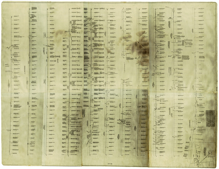
Jacob Kuechler's Field Notes (Field Book), Texas & Pacific Ry. Co. 80 Mile Reserve

Print $222.00
- Digital $50.00
Jacob Kuechler's Field Notes (Field Book), Texas & Pacific Ry. Co. 80 Mile Reserve
1879
Size: 7.9 x 5.4 inches
3050
Map of the Texas & Pacific Ry. Reserve West of the Pecos River

Print $20.00
- Digital $50.00
Map of the Texas & Pacific Ry. Reserve West of the Pecos River
1879
Size: 41.1 x 29.8 inches
65332
Map of the Texas & Pacific Ry. Reserve West of the Pecos River

Print $20.00
- Digital $50.00
Map of the Texas & Pacific Ry. Reserve West of the Pecos River
1879
Size: 40.8 x 30.2 inches
65333
Map of the Texas & Pacific Ry. Reserve West of the Pecos River

Print $20.00
- Digital $50.00
Map of the Texas & Pacific Ry. Reserve West of the Pecos River
1879
Size: 41.2 x 29.9 inches
65334
Map of the Texas & Pacific Ry. Reserve West of the Pecos River

Print $40.00
- Digital $50.00
Map of the Texas & Pacific Ry. Reserve West of the Pecos River
1879
Size: 55.4 x 118.1 inches
96439
Paul McCombs Field Book on 80 Mile Reservation west of the Pecos

Print $148.00
- Digital $50.00
Paul McCombs Field Book on 80 Mile Reservation west of the Pecos
1883
Size: 7.8 x 6.0 inches
2238
Sectional Map No. 3 of the lands and of the line of the Texas & Pacific Ry. Co. in Reeves and parts of Tom Green, Pecos, Presidio & El Paso Cos.

Print $20.00
- Digital $50.00
Sectional Map No. 3 of the lands and of the line of the Texas & Pacific Ry. Co. in Reeves and parts of Tom Green, Pecos, Presidio & El Paso Cos.
1885
Size: 22.3 x 17.4 inches
2303
Map of Texas and Pacific Ry. Company's Surveys in the 80 Mile Reserve

Print $40.00
- Digital $50.00
Map of Texas and Pacific Ry. Company's Surveys in the 80 Mile Reserve
1885
Size: 41.5 x 91.8 inches
60313
Map of Texas and Pacific Ry. Company's Surveys in the 80 Mile Reserve

Print $40.00
- Digital $50.00
Map of Texas and Pacific Ry. Company's Surveys in the 80 Mile Reserve
1885
Size: 44.0 x 51.6 inches
83557
Map of Texas and Pacific Ry. Company's Surveys in the 80 Mile Reserve

Print $20.00
- Digital $50.00
Map of Texas and Pacific Ry. Company's Surveys in the 80 Mile Reserve
1885
Size: 44.0 x 46.6 inches
83558
[Index map of T. & P. Ry. Company’s 80-mile Trans-Pecos Reserve’s perpetuated corners - South Part]
Print $40.00
- Digital $50.00
[Index map of T. & P. Ry. Company’s 80-mile Trans-Pecos Reserve’s perpetuated corners - South Part]
-
Size
23.1 x 90.1 inches
-
Map/Doc
69766
Current Miscellaneous File 29
Print $10.00
- Digital $50.00
Current Miscellaneous File 29
-
Size
11.2 x 8.8 inches
-
Map/Doc
73920
Andrews County Rolled Sketch 42
Print $20.00
- Digital $50.00
Andrews County Rolled Sketch 42
-
Size
27.3 x 36.0 inches
-
Map/Doc
77182
[Map showing T&P Lands in El Paso County]
Print $20.00
[Map showing T&P Lands in El Paso County]
-
Size
17.5 x 22.3 inches
-
Map/Doc
88930
[Map showing T&P Lands in El Paso County]
Print $20.00
[Map showing T&P Lands in El Paso County]
-
Size
22.4 x 17.3 inches
-
Map/Doc
88931
[Map showing T&P Lands in El Paso County]
Print $20.00
[Map showing T&P Lands in El Paso County]
-
Size
22.2 x 17.1 inches
-
Map/Doc
88932
[Map showing T&P Lands in El Paso County]
Print $20.00
[Map showing T&P Lands in El Paso County]
-
Size
17.2 x 22.1 inches
-
Map/Doc
88933
[Map showing T&P Lands in El Paso County]
Print $20.00
[Map showing T&P Lands in El Paso County]
-
Size
17.3 x 22.2 inches
-
Map/Doc
88934
[Map showing T&P Lands in El Paso County]
Print $20.00
[Map showing T&P Lands in El Paso County]
-
Size
22.2 x 17.4 inches
-
Map/Doc
88935
[Map showing T&P Lands in El Paso County]
Print $20.00
[Map showing T&P Lands in El Paso County]
-
Size
22.6 x 17.5 inches
-
Map/Doc
88936
[Map showing T&P Lands in El Paso County]
Print $20.00
[Map showing T&P Lands in El Paso County]
-
Size
22.3 x 17.3 inches
-
Map/Doc
88937
[Map showing T&P Lands in El Paso County]
Print $20.00
[Map showing T&P Lands in El Paso County]
-
Size
22.4 x 17.2 inches
-
Map/Doc
88938
[Index map of T. & P. Ry. Company’s 80-mile Trans-Pecos Reserve’s perpetuated corners - North Part]
Print $40.00
- Digital $50.00
[Index map of T. & P. Ry. Company’s 80-mile Trans-Pecos Reserve’s perpetuated corners - North Part]
-
Size
25.4 x 92.1 inches
-
Map/Doc
89622
Red River County, Texas
Print $20.00
- Digital $50.00
Red River County, Texas
-
Size
22.2 x 17.2 inches
-
Map/Doc
95756
Map of the State of Texas showing the Line and Lands of the Texas and Pacific Railway Reserved and Donated by the State of Texas
Print $20.00
Map of the State of Texas showing the Line and Lands of the Texas and Pacific Railway Reserved and Donated by the State of Texas
1873
-
Size
20.2 x 25.1 inches
-
Map/Doc
76317
-
Creation Date
1873
Map of the United States showing the Texas & Pacific Railway and its connections
Print $20.00
- Digital $50.00
Map of the United States showing the Texas & Pacific Railway and its connections
1875
-
Size
11.9 x 16.8 inches
-
Map/Doc
93960
-
Creation Date
1875
A Geographically Correct Map of the State of Texas
Print $20.00
- Digital $50.00
A Geographically Correct Map of the State of Texas
1876
-
Size
19.6 x 21.4 inches
-
Map/Doc
96508
-
Creation Date
1876
[Center Line of the Texas and Pacific Railroad Company 16 Mile Reserve]
Print $40.00
- Digital $50.00
[Center Line of the Texas and Pacific Railroad Company 16 Mile Reserve]
1876
-
Size
43.1 x 55.6 inches
-
Map/Doc
3125
-
Creation Date
1876
Texas and Pacific Railway and its connections.
Print $20.00
Texas and Pacific Railway and its connections.
1876
-
Size
17.3 x 34.3 inches
-
Map/Doc
93601
-
Creation Date
1876
A Geographically Correct Map of the State of Texas
Print $20.00
- Digital $50.00
A Geographically Correct Map of the State of Texas
1878
-
Size
19.5 x 21.0 inches
-
Map/Doc
95757
-
Creation Date
1878
Jacob Kuechler's Field Notes (Field Book), Texas & Pacific Ry. Co. 80 Mile Reserve
Print $222.00
- Digital $50.00
Jacob Kuechler's Field Notes (Field Book), Texas & Pacific Ry. Co. 80 Mile Reserve
1879
-
Size
7.9 x 5.4 inches
-
Map/Doc
3050
-
Creation Date
1879
Map of the Texas & Pacific Ry. Reserve West of the Pecos River
Print $20.00
- Digital $50.00
Map of the Texas & Pacific Ry. Reserve West of the Pecos River
1879
-
Size
41.1 x 29.8 inches
-
Map/Doc
65332
-
Creation Date
1879
Map of the Texas & Pacific Ry. Reserve West of the Pecos River
Print $20.00
- Digital $50.00
Map of the Texas & Pacific Ry. Reserve West of the Pecos River
1879
-
Size
40.8 x 30.2 inches
-
Map/Doc
65333
-
Creation Date
1879
Map of the Texas & Pacific Ry. Reserve West of the Pecos River
Print $20.00
- Digital $50.00
Map of the Texas & Pacific Ry. Reserve West of the Pecos River
1879
-
Size
41.2 x 29.9 inches
-
Map/Doc
65334
-
Creation Date
1879
Map of the Texas & Pacific Ry. Reserve West of the Pecos River
Print $40.00
- Digital $50.00
Map of the Texas & Pacific Ry. Reserve West of the Pecos River
1879
-
Size
55.4 x 118.1 inches
-
Map/Doc
96439
-
Creation Date
1879
Paul McCombs Field Book on 80 Mile Reservation west of the Pecos
Print $148.00
- Digital $50.00
Paul McCombs Field Book on 80 Mile Reservation west of the Pecos
1883
-
Size
7.8 x 6.0 inches
-
Map/Doc
2238
-
Creation Date
1883
Sectional Map No. 3 of the lands and of the line of the Texas & Pacific Ry. Co. in Reeves and parts of Tom Green, Pecos, Presidio & El Paso Cos.
Print $20.00
- Digital $50.00
Sectional Map No. 3 of the lands and of the line of the Texas & Pacific Ry. Co. in Reeves and parts of Tom Green, Pecos, Presidio & El Paso Cos.
1885
-
Size
22.3 x 17.4 inches
-
Map/Doc
2303
-
Creation Date
1885
Map of Texas and Pacific Ry. Company's Surveys in the 80 Mile Reserve
Print $40.00
- Digital $50.00
Map of Texas and Pacific Ry. Company's Surveys in the 80 Mile Reserve
1885
-
Size
41.5 x 91.8 inches
-
Map/Doc
60313
-
Creation Date
1885
Map of Texas and Pacific Ry. Company's Surveys in the 80 Mile Reserve
Print $40.00
- Digital $50.00
Map of Texas and Pacific Ry. Company's Surveys in the 80 Mile Reserve
1885
-
Size
44.0 x 51.6 inches
-
Map/Doc
83557
-
Creation Date
1885
Map of Texas and Pacific Ry. Company's Surveys in the 80 Mile Reserve
Print $20.00
- Digital $50.00
Map of Texas and Pacific Ry. Company's Surveys in the 80 Mile Reserve
1885
-
Size
44.0 x 46.6 inches
-
Map/Doc
83558
-
Creation Date
1885