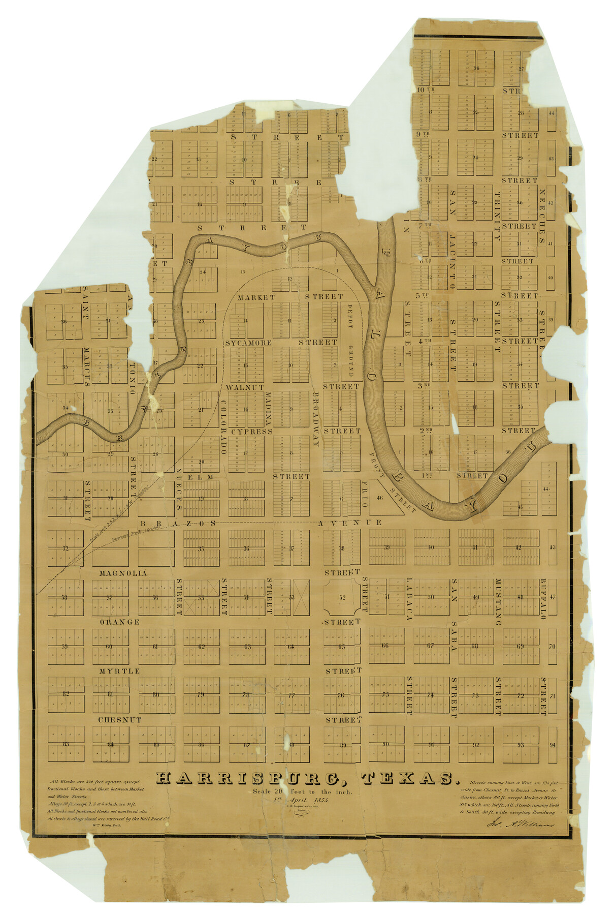
Harrisburg, Texas
A-6-31
-
Map/Doc
3044
-
Collection
General Map Collection
-
Object Dates
4/1/1854 (Creation Date)
-
People and Organizations
L. H. Bradford and Company (Printer)
John A. Williams (Surveyor/Engineer)
William Kirby (Draftsman)
-
Counties
Harris
-
Subjects
City
-
Height x Width
39.4 x 25.7 inches
100.1 x 65.3 cm
-
Medium
paper, etching/engraving/lithograph
-
Scale
1" = 200 ft.
-
Comments
Conservation funded in 2002 with donations from John Daugherty Realtors and Cooke and Skidmore Consulting Corporation.
-
Features
Buffalo Bayou
Harrisburg
Brays Bayou
BBB&C
-
URLs
https://medium.com/save-texas-history/mapping-texas-from-frontier-to-the-lone-star-state-harrisburg-texas-7c66053d8c2
Part of: General Map Collection
Denton County Sketch File 36a

Print $6.00
- Digital $50.00
Denton County Sketch File 36a
1898
Size 11.3 x 9.1 inches
Map/Doc 20773
Ellis County Sketch File 2

Print $11.00
- Digital $50.00
Ellis County Sketch File 2
1858
Size 8.4 x 9.7 inches
Map/Doc 21827
Maps of Gulf Intracoastal Waterway, Texas - Sabine River to the Rio Grande and connecting waterways including ship channels

Print $20.00
- Digital $50.00
Maps of Gulf Intracoastal Waterway, Texas - Sabine River to the Rio Grande and connecting waterways including ship channels
1966
Size 14.5 x 22.3 inches
Map/Doc 61933
Live Oak County Sketch File 20

Print $14.00
- Digital $50.00
Live Oak County Sketch File 20
1898
Size 11.4 x 8.8 inches
Map/Doc 30290
Map of Oceania engraved to illustrate Mitchell's school and family geography

Print $20.00
- Digital $50.00
Map of Oceania engraved to illustrate Mitchell's school and family geography
1839
Size 9.5 x 11.8 inches
Map/Doc 93508
Rusk County Working Sketch 27

Print $20.00
- Digital $50.00
Rusk County Working Sketch 27
Size 35.6 x 29.3 inches
Map/Doc 63663
Galveston County Sketch File 75

Print $12.00
- Digital $50.00
Galveston County Sketch File 75
2011
Size 11.0 x 8.5 inches
Map/Doc 95180
Williamson County Working Sketch 18

Print $20.00
- Digital $50.00
Williamson County Working Sketch 18
Size 26.1 x 26.6 inches
Map/Doc 72578
Morris County Rolled Sketch 2A

Print $20.00
- Digital $50.00
Morris County Rolled Sketch 2A
Size 24.0 x 18.8 inches
Map/Doc 10246
Montague County Working Sketch 19

Print $20.00
- Digital $50.00
Montague County Working Sketch 19
1952
Size 26.4 x 21.5 inches
Map/Doc 71085
Limestone County

Print $40.00
- Digital $50.00
Limestone County
1922
Size 48.1 x 35.4 inches
Map/Doc 16880
Tarrant County Working Sketch 5

Print $20.00
- Digital $50.00
Tarrant County Working Sketch 5
Size 27.7 x 27.3 inches
Map/Doc 62422
You may also like
Milam County Boundary File 1

Print $8.00
- Digital $50.00
Milam County Boundary File 1
Size 12.7 x 8.2 inches
Map/Doc 57198
Limestone Co.

Print $40.00
- Digital $50.00
Limestone Co.
1971
Size 48.3 x 33.4 inches
Map/Doc 73221
Foard County Working Sketch 7

Print $20.00
- Digital $50.00
Foard County Working Sketch 7
1953
Size 26.0 x 32.7 inches
Map/Doc 69198
Gray County Boundary File 9

Print $6.00
- Digital $50.00
Gray County Boundary File 9
Size 11.6 x 9.1 inches
Map/Doc 53902
Harris County Historic Topographic 4

Print $20.00
- Digital $50.00
Harris County Historic Topographic 4
1916
Size 14.5 x 24.6 inches
Map/Doc 65814
Hardeman County Working Sketch 5

Print $20.00
- Digital $50.00
Hardeman County Working Sketch 5
Size 23.0 x 35.7 inches
Map/Doc 63386
Map of the Capitol Land Reservation

Print $20.00
- Digital $50.00
Map of the Capitol Land Reservation
Size 25.4 x 24.3 inches
Map/Doc 90642
Brewster County Working Sketch 39

Print $20.00
- Digital $50.00
Brewster County Working Sketch 39
1944
Size 26.8 x 37.5 inches
Map/Doc 67573
Proceedings of The International (Water) Boundary Commission United States and Mexico Treaties of 1884 and 1889, Volume 2

Proceedings of The International (Water) Boundary Commission United States and Mexico Treaties of 1884 and 1889, Volume 2
Map/Doc 83145


Flight Mission No. BRE-5P, Frame 199, Nueces County

Print $20.00
- Digital $50.00
Flight Mission No. BRE-5P, Frame 199, Nueces County
1956
Size 18.4 x 22.3 inches
Map/Doc 86839