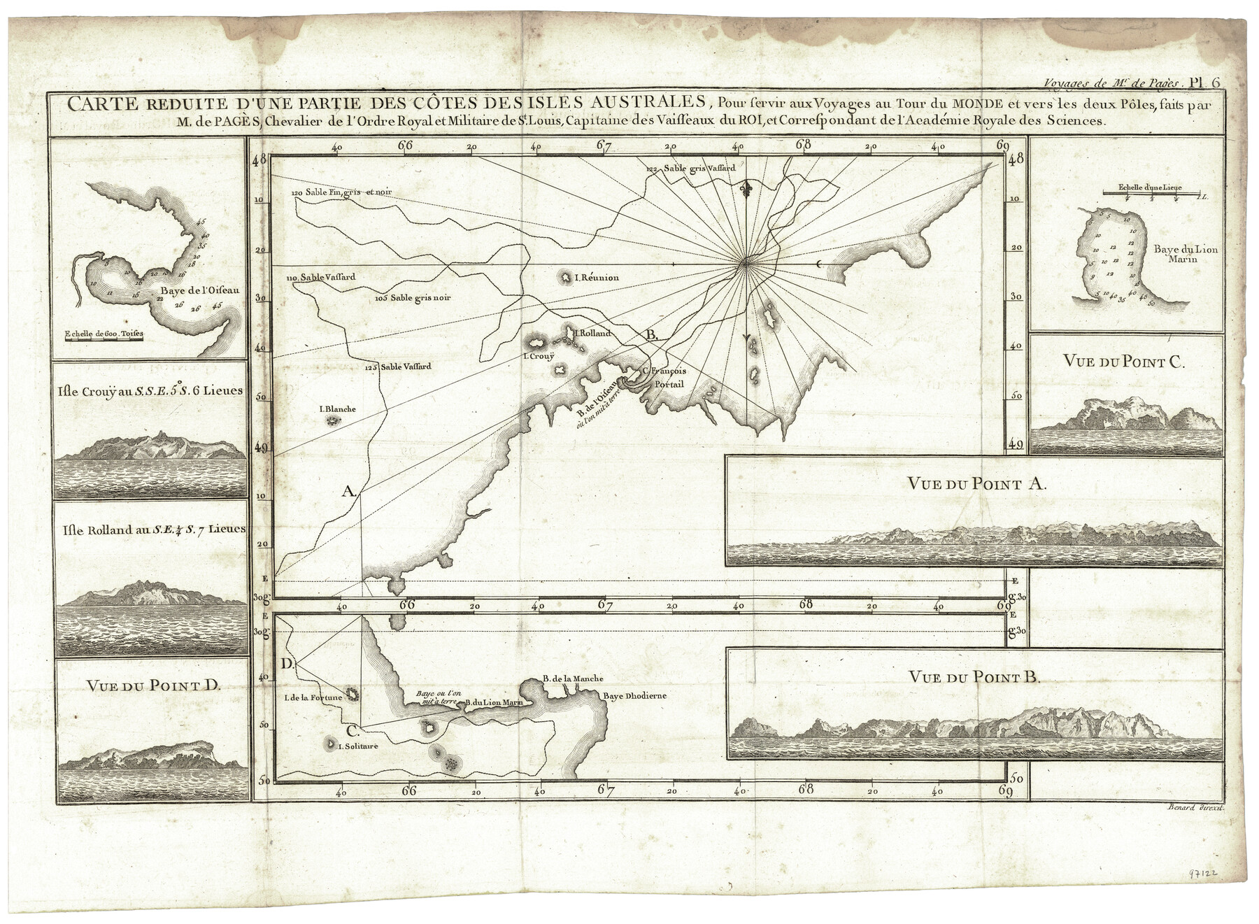
Carte Reduit d'une partie des Côtes des Isles Australes
Pour servir aux Voyages au Tour du Monde et vers les deux Pôles, faits par M. de Pagès, Chevalier de l'Ordre Royal et Militaire de St. Louis, Capitaine des Vaisseaux du Roi, et Correspondant de l'Académie Royale des Sciences
-
Map/Doc
97122
-
Collection
General Map Collection
-
Object Dates
1782 (Creation Date)
-
Height x Width
12.7 x 17.3 inches
32.3 x 43.9 cm
-
Comments
Map appears in "Voyages Autour du Monde, et vers les deux poles par terre et par mer - Tome Second" (97086)
Related maps
Carte d'une partie de l'Amérique Séptentrionale, qui contient partie de la Nle. Espagne, et de la Louisiane

Print $20.00
- Digital $50.00
Carte d'une partie de l'Amérique Séptentrionale, qui contient partie de la Nle. Espagne, et de la Louisiane
1782
Size 14.1 x 18.5 inches
Map/Doc 94096
Voyages Autour du Monde, et vers les deux poles par terre et par mer - Tome Second

Voyages Autour du Monde, et vers les deux poles par terre et par mer - Tome Second
1782
Map/Doc 97086
Part of: General Map Collection
Fractional Township No. 8 South Range No. 21 East of the Indian Meridian, Indian Territory

Print $20.00
- Digital $50.00
Fractional Township No. 8 South Range No. 21 East of the Indian Meridian, Indian Territory
1897
Size 19.2 x 24.2 inches
Map/Doc 75238
Waller County Working Sketch 4

Print $20.00
- Digital $50.00
Waller County Working Sketch 4
Size 17.3 x 18.8 inches
Map/Doc 72303
Maverick County Working Sketch 18

Print $20.00
- Digital $50.00
Maverick County Working Sketch 18
Size 44.4 x 35.3 inches
Map/Doc 70910
Kinney County Working Sketch 31

Print $20.00
- Digital $50.00
Kinney County Working Sketch 31
1961
Size 30.9 x 47.3 inches
Map/Doc 70213
Irion County Rolled Sketch 14

Print $20.00
- Digital $50.00
Irion County Rolled Sketch 14
1946
Size 25.3 x 21.9 inches
Map/Doc 6324
Map of Comal County

Print $20.00
- Digital $50.00
Map of Comal County
1862
Size 18.6 x 22.0 inches
Map/Doc 3429
Nacogdoches County Boundary File 1b

Print $20.00
- Digital $50.00
Nacogdoches County Boundary File 1b
Size 21.2 x 4.9 inches
Map/Doc 57580
Coast Chart No. 210 Aransas Pass and Corpus Christi Bay with the coast to latitude 27° 12' Texas

Print $20.00
- Digital $50.00
Coast Chart No. 210 Aransas Pass and Corpus Christi Bay with the coast to latitude 27° 12' Texas
1913
Size 26.8 x 18.2 inches
Map/Doc 72808
Callahan County Sketch File 7

Print $18.00
- Digital $50.00
Callahan County Sketch File 7
Size 10.8 x 8.9 inches
Map/Doc 35863
Runnels County Working Sketch 3

Print $20.00
- Digital $50.00
Runnels County Working Sketch 3
Size 22.1 x 20.3 inches
Map/Doc 63599
San Jacinto River and Tributaries, Texas - Survey of 1939

Print $20.00
- Digital $50.00
San Jacinto River and Tributaries, Texas - Survey of 1939
1939
Size 27.8 x 40.7 inches
Map/Doc 60308
Hall County Working Sketch Graphic Index

Print $20.00
- Digital $50.00
Hall County Working Sketch Graphic Index
1972
Size 41.7 x 33.7 inches
Map/Doc 76563
You may also like
Controlled Mosaic by Jack Amman Photogrammetric Engineers, Inc - Sheet 4

Print $20.00
- Digital $50.00
Controlled Mosaic by Jack Amman Photogrammetric Engineers, Inc - Sheet 4
1954
Size 20.0 x 24.0 inches
Map/Doc 83448
Chambers County NRC Article 33.136 Location Key Sheet

Print $20.00
- Digital $50.00
Chambers County NRC Article 33.136 Location Key Sheet
1983
Size 24.0 x 44.0 inches
Map/Doc 77014
Flight Mission No. BRA-16M, Frame 118, Jefferson County

Print $20.00
- Digital $50.00
Flight Mission No. BRA-16M, Frame 118, Jefferson County
1953
Size 18.6 x 22.1 inches
Map/Doc 85728
Map of C. W. Post's Land in Hockley County, Texas

Print $20.00
- Digital $50.00
Map of C. W. Post's Land in Hockley County, Texas
Size 24.7 x 15.7 inches
Map/Doc 91095
Map of Travis County

Print $20.00
- Digital $50.00
Map of Travis County
1875
Size 20.6 x 26.4 inches
Map/Doc 4093
Frio County Rolled Sketch 12

Print $20.00
- Digital $50.00
Frio County Rolled Sketch 12
1948
Size 36.5 x 45.5 inches
Map/Doc 8904
Texas map showing principal forts

Print $20.00
- Digital $50.00
Texas map showing principal forts
1852
Size 34.7 x 25.1 inches
Map/Doc 2125
Brewster County Sketch File 44

Print $3.00
- Digital $50.00
Brewster County Sketch File 44
Size 11.5 x 9.4 inches
Map/Doc 16311
Pecos County Working Sketch 112

Print $40.00
- Digital $50.00
Pecos County Working Sketch 112
Size 48.1 x 37.0 inches
Map/Doc 71585
Travis County State Real Property Sketch 3

Print $20.00
- Digital $50.00
Travis County State Real Property Sketch 3
1985
Size 34.3 x 35.9 inches
Map/Doc 61694
[Atlas D, Table of Contents]
![78350, [Atlas D, Table of Contents], General Map Collection](https://historictexasmaps.com/wmedia_w700/maps/78350.tif.jpg)
Print $20.00
- Digital $50.00
[Atlas D, Table of Contents]
Size 18.3 x 9.5 inches
Map/Doc 78350
Flight Mission No. CLL-1N, Frame 194, Willacy County

Print $20.00
- Digital $50.00
Flight Mission No. CLL-1N, Frame 194, Willacy County
1954
Size 18.5 x 22.1 inches
Map/Doc 87064