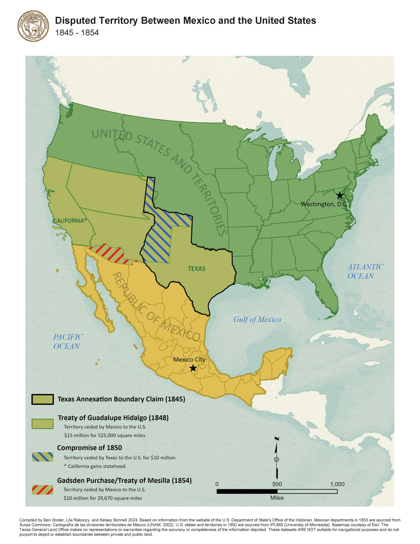
Disputed Territory Between Mexico and the United States
1845-1854
-
Map/Doc
97251
-
Collection
GIS Educational Maps
-
Object Dates
2024 (Creation Date)
-
People and Organizations
Ben Snider (Compiler)
Lila Rakoczy (Compiler)
Kelsey Bonnell (Compiler)
-
Subjects
Geographic Information System Military Mexico United States
-
Height x Width
10.7 x 7.9 inches
27.2 x 20.1 cm
-
Medium
pdf
-
Comments
See "Disputed Territory Between Mexico and the United States, 1845 - 1848" (97129) and “Northern Mexico Campaign of the U.S.-Mexico War, 1846 – 1847” (97152) for additional maps in this series.
Related maps
Disputed Territory Between Mexico and the United States

Disputed Territory Between Mexico and the United States
2023
Size 11.0 x 8.5 inches
Map/Doc 97129
Northern Mexico Campaign of the U.S. - Mexico War

Northern Mexico Campaign of the U.S. - Mexico War
2023
Size 8.5 x 11.0 inches
Map/Doc 97152
Part of: GIS Educational Maps
Contracted Boundaries and Timeline of Mexican Empresario Colonies in Texas

Contracted Boundaries and Timeline of Mexican Empresario Colonies in Texas
2025
Size 17.0 x 11.0 inches
Map/Doc 97439
Disputed Territory Between Mexico and the United States
Disputed Territory Between Mexico and the United States
2023
Size 11.0 x 8.5 inches
Map/Doc 97129
United States Population Distribution by County and Territory, per the U.S. Census of 1870

United States Population Distribution by County and Territory, per the U.S. Census of 1870
2025
Size 8.5 x 11.0 inches
Map/Doc 97479

Aerial View of San Antonio de Béxar and Alamo Fortifications

Aerial View of San Antonio de Béxar and Alamo Fortifications
2026
Size 11.0 x 17.0 inches
Map/Doc 97522
Big Inch and Little Big Inch Pipelines

Big Inch and Little Big Inch Pipelines
2022
Size 8.5 x 11.0 inches
Map/Doc 97089

Disputed Territory Between Mexico and the United States

Disputed Territory Between Mexico and the United States
2024
Size 10.7 x 7.9 inches
Map/Doc 97251

United States Population Distribution by County and Territory, per the U.S. Census of 1900

United States Population Distribution by County and Territory, per the U.S. Census of 1900
2025
Size 8.5 x 11.0 inches
Map/Doc 97481
Events of the Texas Revolution

Events of the Texas Revolution
2023
Size 11.0 x 17.0 inches
Map/Doc 97194
New Mexico and Adjacent Lands

New Mexico and Adjacent Lands
2022
Size 8.5 x 11.0 inches
Map/Doc 96977
You may also like
San Luis Pass to Matagorda Bay

Print $20.00
- Digital $50.00
San Luis Pass to Matagorda Bay
1924
Size 34.5 x 45.6 inches
Map/Doc 69959
Flight Mission No. DAG-21K, Frame 35, Matagorda County

Print $20.00
- Digital $50.00
Flight Mission No. DAG-21K, Frame 35, Matagorda County
1952
Size 18.6 x 22.4 inches
Map/Doc 86402
Shelby County Working Sketch 25

Print $20.00
- Digital $50.00
Shelby County Working Sketch 25
1948
Size 23.5 x 36.2 inches
Map/Doc 63879
Flight Mission No. CRC-4R, Frame 184, Chambers County

Print $20.00
- Digital $50.00
Flight Mission No. CRC-4R, Frame 184, Chambers County
1956
Size 18.6 x 22.3 inches
Map/Doc 84935
Calhoun County Sketch File 9

Print $14.00
- Digital $50.00
Calhoun County Sketch File 9
1953
Size 11.5 x 14.0 inches
Map/Doc 35936
Kimble County

Print $40.00
- Digital $50.00
Kimble County
1930
Size 44.8 x 50.3 inches
Map/Doc 95557
J. De Cordova's Map of the State of Texas Compiled from the records of the General Land Office of the State

Print $20.00
- Digital $50.00
J. De Cordova's Map of the State of Texas Compiled from the records of the General Land Office of the State
1849
Size 36.0 x 34.0 inches
Map/Doc 93930
Chipman's Map of Briscoe, Hall, Motley, Cottle Counties

Print $40.00
- Digital $50.00
Chipman's Map of Briscoe, Hall, Motley, Cottle Counties
1911
Size 54.7 x 92.6 inches
Map/Doc 2051
Pecos County Sketch File 110

Print $22.00
- Digital $50.00
Pecos County Sketch File 110
1913
Size 12.9 x 8.8 inches
Map/Doc 34041
[Galveston, Harrisburg & San Antonio Railway]
![64405, [Galveston, Harrisburg & San Antonio Railway], General Map Collection](https://historictexasmaps.com/wmedia_w700/maps/64405.tif.jpg)
Print $20.00
- Digital $50.00
[Galveston, Harrisburg & San Antonio Railway]
1892
Size 13.5 x 33.6 inches
Map/Doc 64405
Glasscock County Sketch File 27

Print $10.00
- Digital $50.00
Glasscock County Sketch File 27
1989
Size 11.3 x 8.8 inches
Map/Doc 24206
Ed F. Mann's Subdivision of Stephens County School Land, Crosby County, Texas

Print $20.00
- Digital $50.00
Ed F. Mann's Subdivision of Stephens County School Land, Crosby County, Texas
Size 19.4 x 22.2 inches
Map/Doc 92600