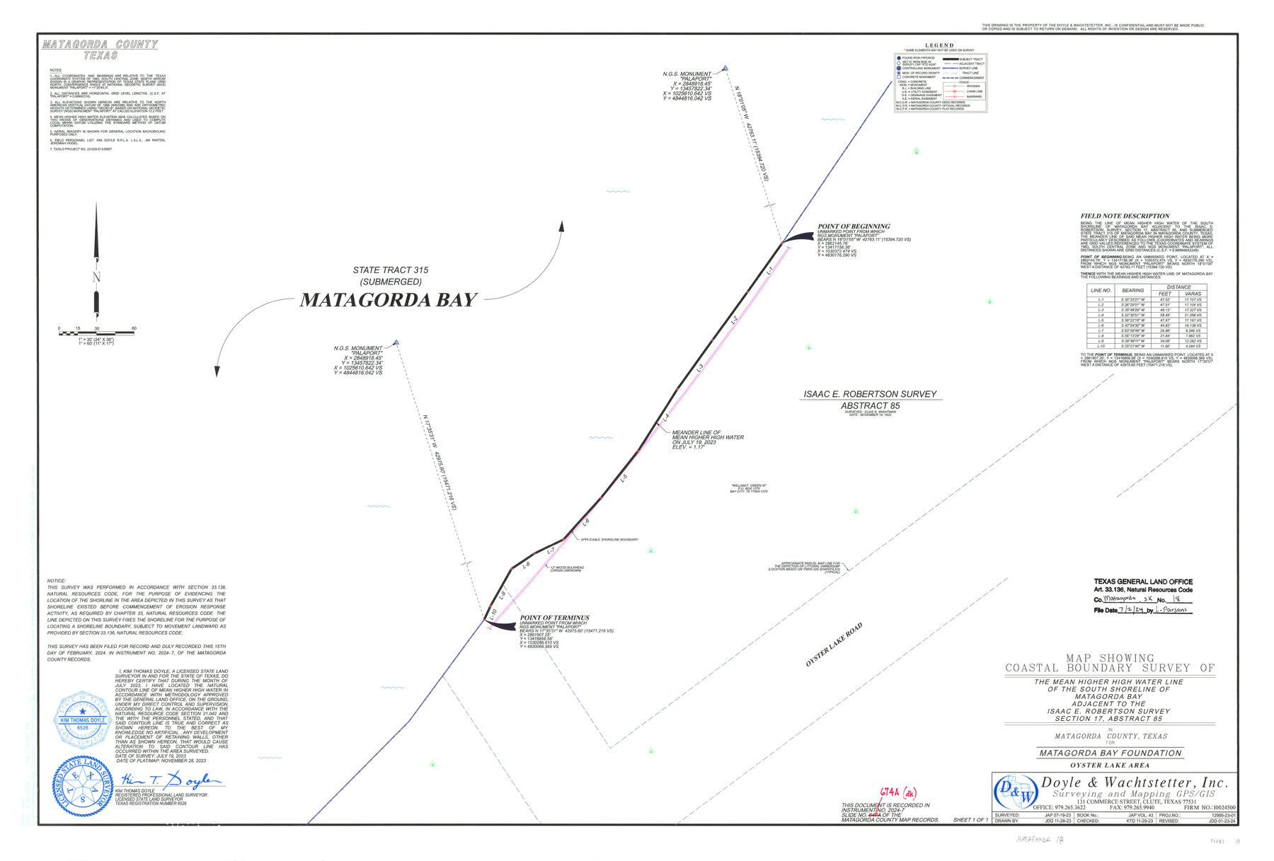
Matagorda County NRC Article 33.136 Sketch 18
Coastal Boundary Survey of the mean higher high water line of the south shoreline of Matagorda Bay adjacent to the Isaac E. Robertson Survey Section 17, Abstract 85
-
Map/Doc
97283
-
Collection
General Map Collection
-
Object Dates
11/28/2023 (Creation Date)
7/2/2024 (File Date)
7/19/2023 (Survey Date)
1/23/2024 (Revision Date)
-
People and Organizations
Kim Thomas Doyle (Surveyor/Engineer)
-
Counties
Matagorda
-
Subjects
Surveying CBS
-
Comments
Project: Matagorda Bay Foundation - Oyster Lake Area, Matagorda County
Project No.: TGLO CMP No. 23-020-013-D607
Part of: General Map Collection
Map of Zapata County

Print $40.00
- Digital $50.00
Map of Zapata County
1901
Size 49.1 x 42.4 inches
Map/Doc 63144
Flight Mission No. DQN-5K, Frame 29, Calhoun County

Print $20.00
- Digital $50.00
Flight Mission No. DQN-5K, Frame 29, Calhoun County
1953
Size 18.5 x 22.3 inches
Map/Doc 84380
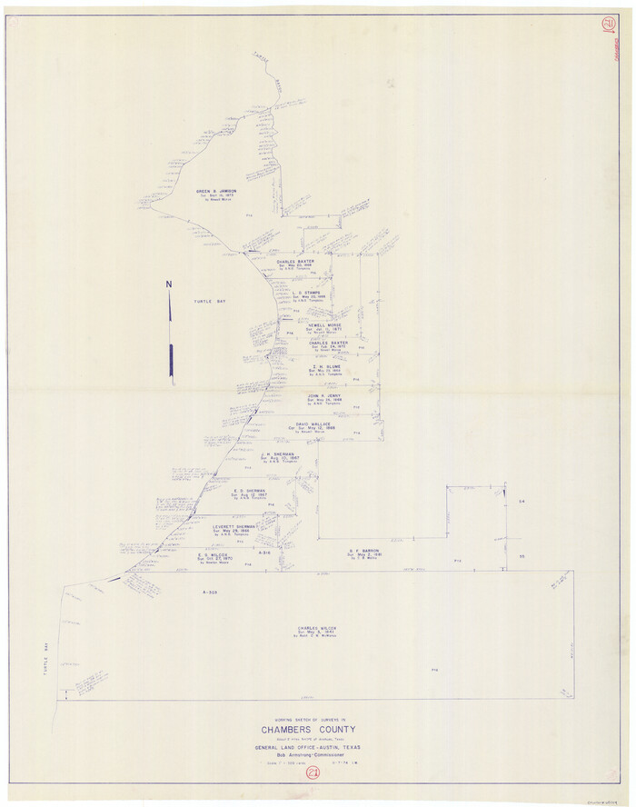
Chambers County Working Sketch 21
Print $20.00
- Digital $50.00
Chambers County Working Sketch 21
1974
Size 44.1 x 34.8 inches
Map/Doc 68004
Bailey County Sketch File 4

Print $8.00
- Digital $50.00
Bailey County Sketch File 4
1907
Size 14.2 x 8.7 inches
Map/Doc 13954
Flight Mission No. DQO-2K, Frame 94, Galveston County

Print $20.00
- Digital $50.00
Flight Mission No. DQO-2K, Frame 94, Galveston County
1952
Size 18.7 x 22.4 inches
Map/Doc 85021
Uvalde County Sketch File 22

Print $30.00
- Digital $50.00
Uvalde County Sketch File 22
1919
Size 9.7 x 8.6 inches
Map/Doc 39008
Galveston County Rolled Sketch 43B

Print $20.00
- Digital $50.00
Galveston County Rolled Sketch 43B
Size 27.3 x 16.2 inches
Map/Doc 76006
Bexar County Rolled Sketch 4B

Print $20.00
- Digital $50.00
Bexar County Rolled Sketch 4B
1989
Size 24.3 x 36.7 inches
Map/Doc 5139
Flight Mission No. BRE-2P, Frame 69, Nueces County

Print $20.00
- Digital $50.00
Flight Mission No. BRE-2P, Frame 69, Nueces County
1956
Size 18.6 x 22.5 inches
Map/Doc 86764
Gulf Coast of the United States, Key West to Rio Grande

Print $20.00
- Digital $50.00
Gulf Coast of the United States, Key West to Rio Grande
1892
Size 27.3 x 18.3 inches
Map/Doc 72670
Red River County Sketch File 25

Print $20.00
- Digital $50.00
Red River County Sketch File 25
Size 26.0 x 38.9 inches
Map/Doc 10586
Nueces County NRC Article 33.136 Sketch 9

Print $32.00
- Digital $50.00
Nueces County NRC Article 33.136 Sketch 9
2005
Size 22.2 x 33.5 inches
Map/Doc 83414
You may also like
Presidio County Rolled Sketch 36

Print $20.00
- Digital $50.00
Presidio County Rolled Sketch 36
Size 20.7 x 21.8 inches
Map/Doc 7334
Maverick County Rolled Sketch 20

Print $20.00
- Digital $50.00
Maverick County Rolled Sketch 20
Size 24.5 x 38.7 inches
Map/Doc 6712
Capitol Complex, Austin, Texas

Print $20.00
- Digital $50.00
Capitol Complex, Austin, Texas
1974
Size 42.7 x 30.6 inches
Map/Doc 94241
General Highway Map, Borden County, Texas

Print $20.00
General Highway Map, Borden County, Texas
1961
Size 18.3 x 25.0 inches
Map/Doc 79377
Lubbock County Boundary File 1a

Print $20.00
- Digital $50.00
Lubbock County Boundary File 1a
Size 24.8 x 24.4 inches
Map/Doc 56487
Resurvey of H.L. Upshur's April 23, 1853 meanders of the Colorado River from the NE corner of Isaac Decker league to the Congress Avenue Bridge

Print $20.00
- Digital $50.00
Resurvey of H.L. Upshur's April 23, 1853 meanders of the Colorado River from the NE corner of Isaac Decker league to the Congress Avenue Bridge
1915
Size 24.1 x 15.8 inches
Map/Doc 75774
Galveston County Rolled Sketch 14

Print $155.00
- Digital $50.00
Galveston County Rolled Sketch 14
1950
Size 10.1 x 15.3 inches
Map/Doc 44808
Dawson County Working Sketch 15

Print $20.00
- Digital $50.00
Dawson County Working Sketch 15
1955
Size 28.2 x 24.8 inches
Map/Doc 68559
Map of Kerr County, Texas

Print $20.00
- Digital $50.00
Map of Kerr County, Texas
1879
Size 21.7 x 28.5 inches
Map/Doc 526
State of Texas

Print $40.00
- Digital $50.00
State of Texas
1985
Size 50.0 x 53.6 inches
Map/Doc 2486
Menard County Boundary File 1

Print $14.00
- Digital $50.00
Menard County Boundary File 1
Size 12.7 x 8.1 inches
Map/Doc 57035
