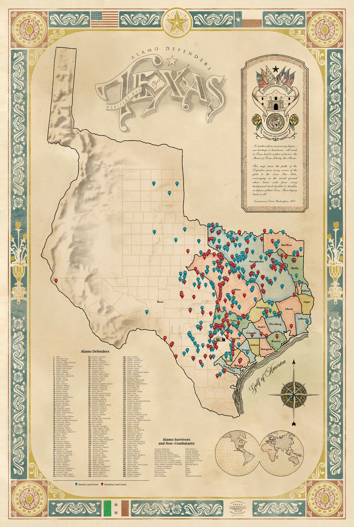
Alamo Defenders Heritage Map of Texas
The Alamo is a sacred place where history, sacrifice, and pride come together to tell the powerful story of our Texas independence. Commissioner Buckingham was honored to commission this map, which reveres the brave Alamo Defenders who sacrificed their lives for freedom.
This one-of-a-kind map displays the various land grants of the Alamo Defenders and the Alamo survivors across the Lone Star State. With the “Gulf of America” prominently displayed on this unique collectible treasure, this map shows that no matter our background, ethnicity, or heritage, the Alamo resonates deeply in every Texan and freedom-loving person across the globe.
“No matter where our journey begins – our heritage or hometown – all roads in Texas lead to a place of honor: the Shrine of Texas Liberty, the Alamo. This map traces the paths of the Defenders from every corner of the globe to the Lone Star State, converging on the sacred ground where brave souls from every background stood shoulder to shoulder in defense of their Texas. Their legacy binds us all.” – Commissioner Dawn Buckingham, M.D.
-
Map/Doc
97433
-
Collection
General Map Collection
-
Object Dates
2025 (Creation Date)
-
People and Organizations
Dawn Buckingham, M.D. (GLO Commissioner)
Lance McIlhany (Graphic Designer)
Brian Imler (Graphic Designer)
Mark Conway (GIS Professional)
-
Subjects
Republic of Texas Military
-
Height x Width
36.0 x 24.0 inches
91.4 x 61.0 cm
Related maps
The Yellow Rose Compass

Price $20.00
The Yellow Rose Compass
2025
Size 3.5 x 2.8 inches
Map/Doc 97508
Part of: General Map Collection
Map of the reconnaissance in Texas by Lieuts Blake & Meade of the Corps of Topl. Engs.

Print $20.00
- Digital $50.00
Map of the reconnaissance in Texas by Lieuts Blake & Meade of the Corps of Topl. Engs.
1846
Size 27.1 x 22.5 inches
Map/Doc 2003
Val Verde County Sketch File 33

Print $40.00
- Digital $50.00
Val Verde County Sketch File 33
Size 17.5 x 13.9 inches
Map/Doc 39249
Calhoun County Rolled Sketch 33

Print $73.00
- Digital $50.00
Calhoun County Rolled Sketch 33
1979
Size 10.0 x 15.2 inches
Map/Doc 43687
Mills County Sketch File 18

Print $4.00
- Digital $50.00
Mills County Sketch File 18
1872
Size 12.1 x 8.1 inches
Map/Doc 31668
Galveston County Sketch File 34

Print $20.00
- Digital $50.00
Galveston County Sketch File 34
1934
Size 11.5 x 20.1 inches
Map/Doc 11536
Travis County Sketch File 12a

Print $5.00
- Digital $50.00
Travis County Sketch File 12a
1859
Size 7.9 x 9.1 inches
Map/Doc 38308

[Gulf, Colorado & Santa Fe]
![64575, [Gulf, Colorado & Santa Fe], General Map Collection](https://historictexasmaps.com/wmedia_w700/maps/64575.tif.jpg)
Print $40.00
- Digital $50.00
[Gulf, Colorado & Santa Fe]
Size 31.9 x 71.7 inches
Map/Doc 64575
San Patricio County NRC Article 33.136 Sketch 7

Print $40.00
- Digital $50.00
San Patricio County NRC Article 33.136 Sketch 7
2014
Size 22.2 x 33.8 inches
Map/Doc 94691
Floyd County Working Sketch 2

Print $20.00
- Digital $50.00
Floyd County Working Sketch 2
1911
Size 41.0 x 24.8 inches
Map/Doc 69181
Flight Mission No. CLL-3N, Frame 32, Willacy County

Print $20.00
- Digital $50.00
Flight Mission No. CLL-3N, Frame 32, Willacy County
1954
Size 18.4 x 22.1 inches
Map/Doc 87088
Bailey County Working Sketch 6

Print $20.00
- Digital $50.00
Bailey County Working Sketch 6
1966
Size 37.0 x 34.5 inches
Map/Doc 67593
You may also like
[Maps of surveys in Reeves & Culberson Cos]
![61146, [Maps of surveys in Reeves & Culberson Cos], General Map Collection](https://historictexasmaps.com/wmedia_w700/maps/61146.tif.jpg)
Print $20.00
- Digital $50.00
[Maps of surveys in Reeves & Culberson Cos]
1937
Size 30.8 x 24.9 inches
Map/Doc 61146
[Blocks B5, 46, and 47]
![91189, [Blocks B5, 46, and 47], Twichell Survey Records](https://historictexasmaps.com/wmedia_w700/maps/91189-1.tif.jpg)
Print $20.00
- Digital $50.00
[Blocks B5, 46, and 47]
1886
Size 23.1 x 16.8 inches
Map/Doc 91189
San Augustine County Working Sketch 20

Print $20.00
- Digital $50.00
San Augustine County Working Sketch 20
1969
Size 15.1 x 24.0 inches
Map/Doc 63708
Clay County Working Sketch 1

Print $20.00
- Digital $50.00
Clay County Working Sketch 1
Size 30.7 x 29.3 inches
Map/Doc 68024
Mills County Boundary File 11

Print $20.00
- Digital $50.00
Mills County Boundary File 11
Size 17.2 x 22.1 inches
Map/Doc 57333
General Highway Map, Fisher County, Texas

Print $20.00
General Highway Map, Fisher County, Texas
1961
Size 18.1 x 24.7 inches
Map/Doc 79466
Gillespie County Sketch File 1

Print $7.00
- Digital $50.00
Gillespie County Sketch File 1
1847
Size 10.2 x 8.3 inches
Map/Doc 24124
Briscoe County Working Sketch 11

Print $20.00
- Digital $50.00
Briscoe County Working Sketch 11
1982
Size 27.5 x 24.3 inches
Map/Doc 67814
Hardin County Sketch File 50

Print $5.00
- Digital $50.00
Hardin County Sketch File 50
Size 13.5 x 9.2 inches
Map/Doc 25204
Map of Nacogdoches County

Print $40.00
- Digital $50.00
Map of Nacogdoches County
1846
Size 83.7 x 76.1 inches
Map/Doc 82243
Foard County Working Sketch 15

Print $40.00
- Digital $50.00
Foard County Working Sketch 15
1982
Size 43.7 x 76.0 inches
Map/Doc 69206
Right of Way and Track Map, the Missouri, Kansas and Texas Ry. of Texas operated by the Missouri, Kansas and Texas Ry. of Texas, San Antonio Division

Print $40.00
- Digital $50.00
Right of Way and Track Map, the Missouri, Kansas and Texas Ry. of Texas operated by the Missouri, Kansas and Texas Ry. of Texas, San Antonio Division
1918
Size 25.6 x 58.7 inches
Map/Doc 64581