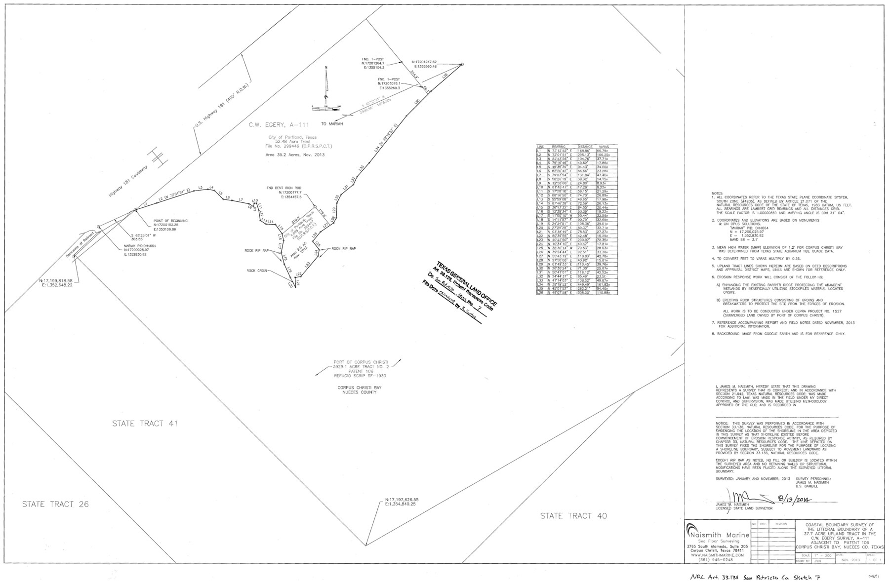
San Patricio County NRC Article 33.136 Sketch 7
Coastal Boundary Survey of the littoral boundary of a 37.7 acre upland tract in the C.G. Egery survey, A-111 adjacent to patent 106
-
Map/Doc
94691
-
Collection
General Map Collection
-
Object Dates
2013 (Survey Date)
2014/8/19 (Creation Date)
2018/6/22 (File Date)
-
People and Organizations
James M. Naismith (Surveyor/Engineer)
-
Counties
San Patricio
-
Subjects
Surveying CBS
-
Height x Width
22.2 x 33.8 inches
56.4 x 85.9 cm
-
Medium
multi-page, multi-format
-
Scale
1" = 200'
-
Comments
Project: Indian Point Shoreline Protection Project No.: CEPRA 1527
Part of: General Map Collection
Hill County Sketch File 17

Print $4.00
- Digital $50.00
Hill County Sketch File 17
1860
Size 12.5 x 8.3 inches
Map/Doc 26484
Travis County Working Sketch 67

Print $20.00
- Digital $50.00
Travis County Working Sketch 67
2017
Size 24.6 x 36.6 inches
Map/Doc 94123
Flight Mission No. DAH-9M, Frame 87, Orange County

Print $20.00
- Digital $50.00
Flight Mission No. DAH-9M, Frame 87, Orange County
1953
Size 18.5 x 22.3 inches
Map/Doc 86851
Flight Mission No. BRE-5P, Frame 191, Nueces County

Print $20.00
- Digital $50.00
Flight Mission No. BRE-5P, Frame 191, Nueces County
1956
Size 18.7 x 22.5 inches
Map/Doc 86837
United States Gulf Coast - from Galveston to the Rio Grande

Print $20.00
- Digital $50.00
United States Gulf Coast - from Galveston to the Rio Grande
1915
Size 26.9 x 18.3 inches
Map/Doc 72732
Rusk County Working Sketch 37b

Print $40.00
- Digital $50.00
Rusk County Working Sketch 37b
2007
Size 50.0 x 31.0 inches
Map/Doc 87497
Montgomery County Sketch File 41

Print $8.00
- Digital $50.00
Montgomery County Sketch File 41
2004
Size 14.0 x 8.5 inches
Map/Doc 82447
Map of the State of Texas published by the International and Gt. Northern Railroad

Print $20.00
- Digital $50.00
Map of the State of Texas published by the International and Gt. Northern Railroad
1881
Size 16.0 x 22.2 inches
Map/Doc 94092

Orange County Sketch File 43

Print $4.00
- Digital $50.00
Orange County Sketch File 43
1873
Size 8.2 x 10.3 inches
Map/Doc 33385
Kent County Working Sketch 11

Print $20.00
- Digital $50.00
Kent County Working Sketch 11
Size 24.3 x 37.4 inches
Map/Doc 70018
Hardin County Working Sketch 27

Print $20.00
- Digital $50.00
Hardin County Working Sketch 27
1954
Size 22.9 x 27.9 inches
Map/Doc 63425
You may also like
Briscoe County Sketch File 11

Print $9.00
- Digital $50.00
Briscoe County Sketch File 11
Size 11.8 x 11.0 inches
Map/Doc 16422
English Field Notes of the Spanish Archives - Book 12

English Field Notes of the Spanish Archives - Book 12
1832
Map/Doc 96538
Pecos County Rolled Sketch Q

Print $20.00
- Digital $50.00
Pecos County Rolled Sketch Q
Size 18.7 x 12.2 inches
Map/Doc 7311
Montgomery County Working Sketch 23

Print $20.00
- Digital $50.00
Montgomery County Working Sketch 23
1937
Size 42.5 x 37.2 inches
Map/Doc 71130
Map of Padre Island Showing Location of Zoning Districts

Print $20.00
- Digital $50.00
Map of Padre Island Showing Location of Zoning Districts
1971
Size 18.6 x 26.1 inches
Map/Doc 4810
Winkler County Rolled Sketch 5

Print $40.00
- Digital $50.00
Winkler County Rolled Sketch 5
1927
Size 58.0 x 38.4 inches
Map/Doc 10148
Gillespie County Rolled Sketch 3

Print $20.00
- Digital $50.00
Gillespie County Rolled Sketch 3
Size 19.0 x 28.1 inches
Map/Doc 6010
Fort Bend County Sketch File 3

Print $4.00
- Digital $50.00
Fort Bend County Sketch File 3
Size 12.8 x 8.1 inches
Map/Doc 22880
Parker Place Addition

Print $3.00
- Digital $50.00
Parker Place Addition
1952
Size 11.8 x 17.9 inches
Map/Doc 92414
[Pencil sketch of Wm. Rivers survey]
![91968, [Pencil sketch of Wm. Rivers survey], Twichell Survey Records](https://historictexasmaps.com/wmedia_w700/maps/91968-1.tif.jpg)
Print $3.00
- Digital $50.00
[Pencil sketch of Wm. Rivers survey]
Size 10.1 x 16.5 inches
Map/Doc 91968
Flight Mission No. DAG-21K, Frame 117, Matagorda County

Print $20.00
- Digital $50.00
Flight Mission No. DAG-21K, Frame 117, Matagorda County
1952
Size 18.5 x 22.4 inches
Map/Doc 86440
Orange County Working Sketch 52

Print $20.00
- Digital $50.00
Orange County Working Sketch 52
2006
Size 31.9 x 47.5 inches
Map/Doc 83069